The M11 1 postcode sector is within the county of Greater Manchester.
Did you know? According to the 2021 Census, the M11 1 postcode sector is home to a bustling 6,430 residents!
Given that each sector allows for 400 unique postcode combinations. Letters C, I, K, M, O and V are not allowed in the last two letters of a postcode. With 172 postcodes already in use, this leaves 228 units available.
The largest settlements in the M11 1 postal code are MANCHESTER and Openshaw.
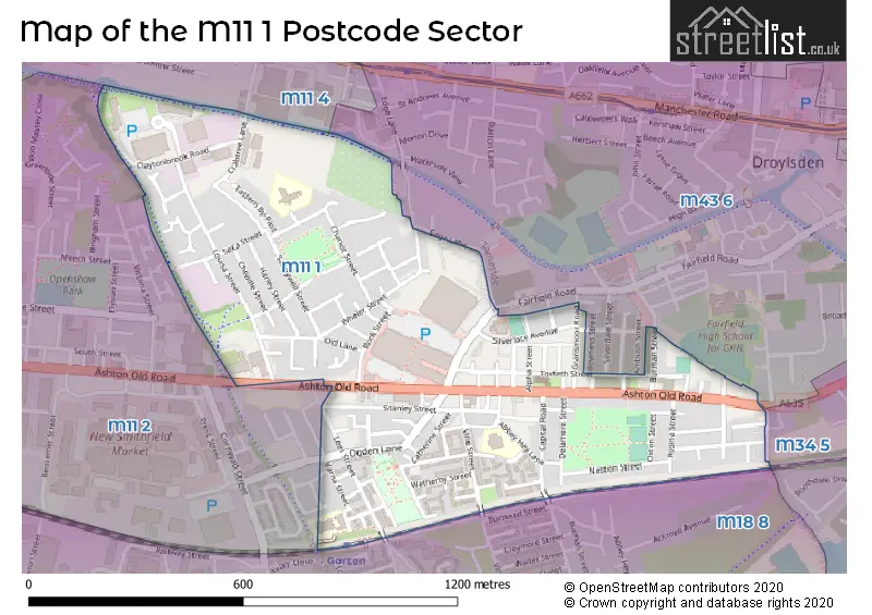
The M11 1 Postcode shares a border with M11 2 (MANCHESTER, Openshaw), M11 4 (MANCHESTER, Openshaw, Clayton), M34 5 (Audenshaw), M43 6 (Droylsden) and M18 8 (MANCHESTER, Abbey Hey).
The sector is within the post town of MANCHESTER.
M11 1 is a postcode sector within the M11 postcode district which is within the M Manchester postcode area.
The Royal Mail delivery office for the M11 1 postal sector is the Openshaw Delivery Office.
The area of the M11 1 postcode sector is 0.42 square miles which is 1.09 square kilometres or 268.67 square acres.
Waterways within the M11 1 postcode sector include the Ashton Canal.

Map of the M11 1 Postcode Sector
Explore the M11 1 postcode sector by using our free interactive map.
| M | 1 | 1 | - | 1 | X | X |
| M | 1 | 1 | Space | 1 | Letter | Letter |
Official List of Streets
MANCHESTER (86 Streets)
Openshaw (36 Streets)
Unofficial Streets or Alternative Spellings
MANCHESTER
PAPRIKA CLOSEDroylsden
BURMAN STREET CHEERYBLE STREET EDGE LANE FAIRFIELD ROAD GRANSMOOR ROADOpenshaw
CHISHOLM STREETAbbey Hey
ABBEY HEY LANE LEES STREETWeather Forecast for M11 1
Press Button to Show Forecast for Fairfield (Nr Tameside)
| Time Period | Icon | Description | Temperature | Rain Probability | Wind |
|---|---|---|---|---|---|
| 06:00 to 09:00 | Cloudy | 14.0°C (feels like 13.0°C) | 4.00% | NE 7 mph | |
| 09:00 to 12:00 | Cloudy | 18.0°C (feels like 18.0°C) | 4.00% | ENE 4 mph | |
| 12:00 to 15:00 | Cloudy | 22.0°C (feels like 19.0°C) | 4.00% | ESE 13 mph | |
| 15:00 to 18:00 | Cloudy | 23.0°C (feels like 20.0°C) | 8.00% | SE 13 mph | |
| 18:00 to 21:00 | Heavy rain shower (day) | 21.0°C (feels like 19.0°C) | 66.00% | SE 9 mph | |
| 21:00 to 00:00 | Heavy rain shower (night) | 17.0°C (feels like 17.0°C) | 62.00% | E 7 mph |
Press Button to Show Forecast for Fairfield (Nr Tameside)
| Time Period | Icon | Description | Temperature | Rain Probability | Wind |
|---|---|---|---|---|---|
| 00:00 to 03:00 | Partly cloudy (night) | 16.0°C (feels like 16.0°C) | 5.00% | S 2 mph | |
| 03:00 to 06:00 | Partly cloudy (night) | 15.0°C (feels like 15.0°C) | 2.00% | ESE 2 mph | |
| 06:00 to 09:00 | Cloudy | 15.0°C (feels like 15.0°C) | 7.00% | SE 4 mph | |
| 09:00 to 12:00 | Cloudy | 17.0°C (feels like 15.0°C) | 4.00% | S 11 mph | |
| 12:00 to 15:00 | Cloudy | 19.0°C (feels like 17.0°C) | 3.00% | S 11 mph | |
| 15:00 to 18:00 | Cloudy | 21.0°C (feels like 17.0°C) | 5.00% | SSE 13 mph | |
| 18:00 to 21:00 | Cloudy | 19.0°C (feels like 17.0°C) | 7.00% | SSE 11 mph | |
| 21:00 to 00:00 | Cloudy | 17.0°C (feels like 15.0°C) | 10.00% | SE 9 mph |
Press Button to Show Forecast for Fairfield (Nr Tameside)
| Time Period | Icon | Description | Temperature | Rain Probability | Wind |
|---|---|---|---|---|---|
| 00:00 to 03:00 | Cloudy | 15.0°C (feels like 14.0°C) | 15.00% | SE 9 mph | |
| 03:00 to 06:00 | Light rain | 15.0°C (feels like 13.0°C) | 51.00% | ESE 9 mph | |
| 06:00 to 09:00 | Light rain | 14.0°C (feels like 13.0°C) | 52.00% | ESE 9 mph | |
| 09:00 to 12:00 | Light rain | 15.0°C (feels like 14.0°C) | 58.00% | ESE 11 mph | |
| 12:00 to 15:00 | Heavy rain | 17.0°C (feels like 15.0°C) | 79.00% | ESE 11 mph | |
| 15:00 to 18:00 | Light rain | 17.0°C (feels like 15.0°C) | 53.00% | SSE 9 mph | |
| 18:00 to 21:00 | Light rain | 16.0°C (feels like 15.0°C) | 54.00% | SSE 7 mph | |
| 21:00 to 00:00 | Cloudy | 14.0°C (feels like 13.0°C) | 14.00% | SE 7 mph |
Press Button to Show Forecast for Fairfield (Nr Tameside)
| Time Period | Icon | Description | Temperature | Rain Probability | Wind |
|---|---|---|---|---|---|
| 00:00 to 03:00 | Cloudy | 13.0°C (feels like 12.0°C) | 7.00% | ESE 7 mph | |
| 03:00 to 06:00 | Clear night | 12.0°C (feels like 11.0°C) | 2.00% | E 7 mph | |
| 06:00 to 09:00 | Partly cloudy (day) | 13.0°C (feels like 12.0°C) | 2.00% | E 7 mph | |
| 09:00 to 12:00 | Partly cloudy (day) | 16.0°C (feels like 15.0°C) | 6.00% | ESE 9 mph | |
| 12:00 to 15:00 | Cloudy | 18.0°C (feels like 17.0°C) | 14.00% | SE 9 mph | |
| 15:00 to 18:00 | Light rain shower (day) | 19.0°C (feels like 17.0°C) | 35.00% | SE 9 mph | |
| 18:00 to 21:00 | Cloudy | 17.0°C (feels like 17.0°C) | 13.00% | SE 7 mph | |
| 21:00 to 00:00 | Clear night | 14.0°C (feels like 14.0°C) | 4.00% | ESE 4 mph |
Press Button to Show Forecast for Fairfield (Nr Tameside)
| Time Period | Icon | Description | Temperature | Rain Probability | Wind |
|---|---|---|---|---|---|
| 00:00 to 03:00 | Clear night | 13.0°C (feels like 12.0°C) | 2.00% | ESE 4 mph | |
| 03:00 to 06:00 | Clear night | 11.0°C (feels like 11.0°C) | 2.00% | E 4 mph | |
| 06:00 to 09:00 | Sunny day | 13.0°C (feels like 12.0°C) | 3.00% | E 4 mph | |
| 09:00 to 12:00 | Partly cloudy (day) | 17.0°C (feels like 16.0°C) | 4.00% | SSW 4 mph | |
| 12:00 to 15:00 | Cloudy | 19.0°C (feels like 18.0°C) | 12.00% | SW 4 mph | |
| 15:00 to 18:00 | Cloudy | 19.0°C (feels like 18.0°C) | 14.00% | WSW 4 mph | |
| 18:00 to 21:00 | Light rain shower (day) | 17.0°C (feels like 17.0°C) | 32.00% | W 4 mph | |
| 21:00 to 00:00 | Light rain shower (night) | 15.0°C (feels like 14.0°C) | 28.00% | W 4 mph |
Schools and Places of Education Within the M11 1 Postcode Sector
Higher Openshaw Community School
Community school
Saunton Road, Manchester, , M11 1AJ
Head: Mr John Dent
Ofsted Rating: Good
Inspection: 2023-06-22 (325 days ago)
Website: Visit Higher Openshaw Community School Website
Phone: 01612233549
Number of Pupils: 324
St Clement's CofE Primary School
Voluntary controlled school
Abbey Hey Lane, Manchester, , M11 1LR
Head: Mrs Jane Parker
Ofsted Rating: Good
Inspection: 2020-02-12 (1551 days ago)
Website: Visit St Clement's CofE Primary School Website
Phone: 01613013268
Number of Pupils: 234
House Prices in the M11 1 Postcode Sector
| Type of Property | 2018 Average | 2018 Sales | 2017 Average | 2017 Sales | 2016 Average | 2016 Sales | 2015 Average | 2015 Sales |
|---|---|---|---|---|---|---|---|---|
| Detached | £156,617 | 6 | £136,000 | 4 | £117,143 | 7 | £0 | 0 |
| Semi-Detached | £161,656 | 62 | £139,143 | 58 | £124,617 | 25 | £91,624 | 4 |
| Terraced | £121,836 | 60 | £115,472 | 60 | £98,032 | 54 | £90,820 | 44 |
| Flats | £57,000 | 1 | £88,352 | 13 | £84,319 | 4 | £55,667 | 3 |
Important Postcodes M11 1 in the Postcode Sector
M11 1AJ is the postcode for MAIN BUILDING, Higher Openshaw Community School, Saunton Road, and Higher Openshaw Community School, Saunton Road
M11 1DA is the postcode for Lime Square Medical Centre, Lime Square, Ashton Old Road
M11 1JG is the postcode for Higher Openshaw Primary Care Centre, Ashton Old Road, Manchester College, 1328-1330 Ashton Old Road, and CHP, Higher Openshaw Primary Care Centre, Ashton Old Road
M11 1LR is the postcode for St. Clements C of E Primary School, Abbey Hey Lane
M11 1WP is the postcode for Barrass Street Primary Provision, Varna Street
| The M11 1 Sector is within these Local Authorities |
|
|---|---|
| The M11 1 Sector is within these Counties |
|
| The M11 1 Sector is within these Water Company Areas |
|