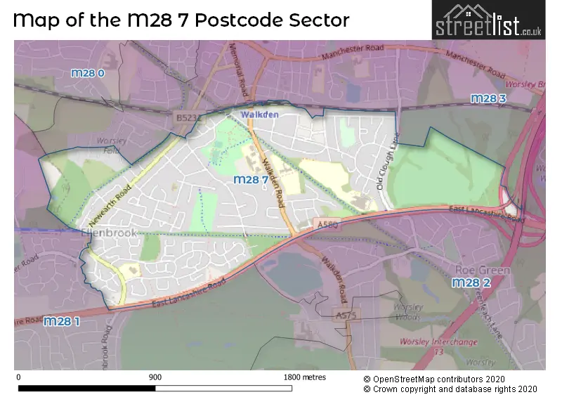
The M28 7 postcode sector is within the county of Greater Manchester.
Did you know? According to the 2021 Census, the M28 7 postcode sector is home to a bustling 7,477 residents!
Given that each sector allows for 400 unique postcode combinations. Letters C, I, K, M, O and V are not allowed in the last two letters of a postcode. With 157 postcodes already in use, this leaves 243 units available.
The M28 7 postal code covers the settlement of Worsley.
The M28 7 Postcode shares a border with M28 2 (Worsley), M28 3 (Worsley) and M28 1 (Worsley).
The sector is within the post town of MANCHESTER.
M28 7 is a postcode sector within the M28 postcode district which is within the M Manchester postcode area.
The Royal Mail delivery office for the M28 7 postal sector is the North West (m) Delivery Office.
The area of the M28 7 postcode sector is 0.91 square miles which is 2.36 square kilometres or 582.96 square acres.
The M28 7 postcode sector is crossed by the M61 motorway.
The M28 7 postcode sector is crossed by the M60 motorway.

Map of the M28 7 Postcode Sector
Explore the M28 7 postcode sector by using our free interactive map.
| M | 2 | 8 | - | 7 | X | X |
| M | 2 | 8 | Space | 7 | Letter | Letter |
Official List of Streets
Worsley (125 Streets)
Unofficial Streets or Alternative Spellings
Worsley
AVONCLIFFE ROAD BRIDGEWATER ROAD BULLBRIDGE VIEW BURGESS WAY DEVONIAN CLOSE ELLENBROOK ROAD FENMAN MEWS HILTON LANE HORSELEY AVENUE LAWNDALE DRIVE MARPLE GARDENS MEMORIAL ROAD MORSTON CLOSE STANLEY ROAD YARNINGDALE AVENUE BROADWAY BRIDGE ELLENBROOK LOOPLINE GILBERT STREET HENNIKER STREET LADYBRIDGE AVENUE LEIGH GUIDED BUSWAY MAPLE GARDENS ROE GREEN LOOPLINE STRETTON CLOSE TYLDESLEY LOOPLINE WOOTON MEWS WOOTTON MEWSGlazebury
EAST LANCASHIRE ROADWeather Forecast for M28 7
Press Button to Show Forecast for Worsley
| Time Period | Icon | Description | Temperature | Rain Probability | Wind |
|---|---|---|---|---|---|
| 21:00 to 00:00 | Partly cloudy (night) | 7.0°C (feels like 4.0°C) | 38.00% | ENE 7 mph |
Press Button to Show Forecast for Worsley
| Time Period | Icon | Description | Temperature | Rain Probability | Wind |
|---|---|---|---|---|---|
| 00:00 to 03:00 | Partly cloudy (night) | 5.0°C (feels like 3.0°C) | 1.00% | ENE 7 mph | |
| 03:00 to 06:00 | Partly cloudy (night) | 4.0°C (feels like 2.0°C) | 2.00% | NE 7 mph | |
| 06:00 to 09:00 | Partly cloudy (day) | 4.0°C (feels like 2.0°C) | 2.00% | NE 7 mph | |
| 09:00 to 12:00 | Cloudy | 8.0°C (feels like 6.0°C) | 6.00% | ENE 9 mph | |
| 12:00 to 15:00 | Overcast | 10.0°C (feels like 7.0°C) | 8.00% | ENE 9 mph | |
| 15:00 to 18:00 | Light rain | 9.0°C (feels like 7.0°C) | 47.00% | ENE 9 mph | |
| 18:00 to 21:00 | Cloudy | 9.0°C (feels like 6.0°C) | 9.00% | NE 9 mph | |
| 21:00 to 00:00 | Cloudy | 7.0°C (feels like 5.0°C) | 4.00% | NE 9 mph |
Press Button to Show Forecast for Worsley
| Time Period | Icon | Description | Temperature | Rain Probability | Wind |
|---|---|---|---|---|---|
| 00:00 to 03:00 | Cloudy | 6.0°C (feels like 3.0°C) | 4.00% | NE 7 mph | |
| 03:00 to 06:00 | Cloudy | 5.0°C (feels like 3.0°C) | 4.00% | NNE 9 mph | |
| 06:00 to 09:00 | Cloudy | 6.0°C (feels like 3.0°C) | 11.00% | N 7 mph | |
| 09:00 to 12:00 | Cloudy | 7.0°C (feels like 5.0°C) | 14.00% | NNW 7 mph | |
| 12:00 to 15:00 | Light rain | 9.0°C (feels like 7.0°C) | 43.00% | NW 9 mph | |
| 15:00 to 18:00 | Cloudy | 10.0°C (feels like 8.0°C) | 12.00% | WNW 11 mph | |
| 18:00 to 21:00 | Sunny day | 10.0°C (feels like 8.0°C) | 4.00% | W 9 mph | |
| 21:00 to 00:00 | Clear night | 8.0°C (feels like 6.0°C) | 2.00% | WSW 7 mph |
Press Button to Show Forecast for Worsley
| Time Period | Icon | Description | Temperature | Rain Probability | Wind |
|---|---|---|---|---|---|
| 00:00 to 03:00 | Partly cloudy (night) | 6.0°C (feels like 4.0°C) | 2.00% | SSW 7 mph | |
| 03:00 to 06:00 | Clear night | 5.0°C (feels like 2.0°C) | 3.00% | SSE 7 mph | |
| 06:00 to 09:00 | Cloudy | 6.0°C (feels like 3.0°C) | 6.00% | SSE 7 mph | |
| 09:00 to 12:00 | Partly cloudy (day) | 10.0°C (feels like 8.0°C) | 3.00% | S 11 mph | |
| 12:00 to 15:00 | Cloudy | 13.0°C (feels like 10.0°C) | 8.00% | S 13 mph | |
| 15:00 to 18:00 | Cloudy | 13.0°C (feels like 11.0°C) | 11.00% | S 13 mph | |
| 18:00 to 21:00 | Cloudy | 13.0°C (feels like 10.0°C) | 10.00% | S 11 mph | |
| 21:00 to 00:00 | Clear night | 11.0°C (feels like 9.0°C) | 4.00% | SSE 11 mph |
Press Button to Show Forecast for Worsley
| Time Period | Icon | Description | Temperature | Rain Probability | Wind |
|---|---|---|---|---|---|
| 00:00 to 03:00 | Partly cloudy (night) | 9.0°C (feels like 7.0°C) | 4.00% | SE 9 mph | |
| 03:00 to 06:00 | Partly cloudy (night) | 8.0°C (feels like 6.0°C) | 4.00% | SE 9 mph | |
| 06:00 to 09:00 | Sunny day | 9.0°C (feels like 6.0°C) | 3.00% | ESE 9 mph | |
| 09:00 to 12:00 | Partly cloudy (day) | 12.0°C (feels like 10.0°C) | 5.00% | ESE 11 mph | |
| 12:00 to 15:00 | Partly cloudy (day) | 15.0°C (feels like 12.0°C) | 6.00% | SE 13 mph | |
| 15:00 to 18:00 | Cloudy | 16.0°C (feels like 13.0°C) | 13.00% | SE 11 mph | |
| 18:00 to 21:00 | Partly cloudy (day) | 15.0°C (feels like 13.0°C) | 8.00% | ESE 11 mph | |
| 21:00 to 00:00 | Cloudy | 13.0°C (feels like 11.0°C) | 9.00% | E 9 mph |
Schools and Places of Education Within the M28 7 Postcode Sector
Co-op Academy Walkden
Academy converter
Old Clough Lane, Manchester, , M28 7JB
Head: Mr Matt Hacker
Ofsted Rating: Good
Inspection: 2023-05-24 (338 days ago)
Website: Visit Co-op Academy Walkden Website
Phone: 01618501625
Number of Pupils: 1503
Ellenbrook Community Primary School
Community school
Longwall Avenue, Manchester, , M28 7PS
Head: Mr Roger Blackburn
Ofsted Rating: Outstanding
Inspection: 2023-05-19 (343 days ago)
Website: Visit Ellenbrook Community Primary School Website
Phone: 01617996347
Number of Pupils: 436
House Prices in the M28 7 Postcode Sector
| Type of Property | 2018 Average | 2018 Sales | 2017 Average | 2017 Sales | 2016 Average | 2016 Sales | 2015 Average | 2015 Sales |
|---|---|---|---|---|---|---|---|---|
| Detached | £352,911 | 38 | £321,453 | 53 | £313,153 | 32 | £256,089 | 28 |
| Semi-Detached | £226,566 | 96 | £206,619 | 90 | £184,001 | 67 | £173,158 | 52 |
| Terraced | £195,070 | 45 | £175,868 | 25 | £157,583 | 24 | £142,566 | 22 |
| Flats | £105,547 | 3 | £107,774 | 9 | £0 | 0 | £0 | 0 |
Important Postcodes M28 7 in the Postcode Sector
M28 7EE is the postcode for Worsley Maintenance Depot, Chestnut Avenue
M28 7FG is the postcode for Mesne Lea Primary School, Walkden Road, and MESNE LEA PRIMARY SCHOOL, WALKDEN ROAD, WORSLEY
M28 7FJ is the postcode for Walkden High School, Birch Road
M28 7HE is the postcode for JAMES BRINDLEY COMMUNITY PRIMARY SCHOOL, PARRFOLD AVENUE, and James Brindley Infant & Junior School, Parr Fold Avenue
M28 7JB is the postcode for Co-op Academy Walkden, 211 Old Clough Lane, Co-Op Academy Walkden, Old Clough Lane, and Walkden High School, 211 Old Clough Lane
M28 7PS is the postcode for Ellenbrook Primary School, 2 Longwall Avenue, Worsley, and Ellenbrook Primary School, 2 Longwall Avenue
M28 7QD is the postcode for REFECTORY BLOCK, Salford College, Worsley Campus, Walkden Road, TEACHING BLOCK, Salford College, Worsley Campus, Walkden Road, LEARNING RESEARCH CENTRE, Salford College, Worsley Campus, Walkden Road, ART BLOCK, Salford College, Worsley Campus, Walkden Road, ADMINISTRATION BLOCK, Salford College, Worsley Campus, Walkden Road, and SPORTS CENTRE, Salford College, Worsley Campus, Walkden Road
| The M28 7 Sector is within these Local Authorities |
|
|---|---|
| The M28 7 Sector is within these Counties |
|
| The M28 7 Sector is within these Water Company Areas |
|