The M33 4 postcode sector is within the county of Greater Manchester.
Did you know? According to the 2021 Census, the M33 4 postcode sector is home to a bustling 13,765 residents!
Given that each sector allows for 400 unique postcode combinations. Letters C, I, K, M, O and V are not allowed in the last two letters of a postcode. With 272 postcodes already in use, this leaves 128 units available.
The M33 4 postal code covers the settlement of SALE.
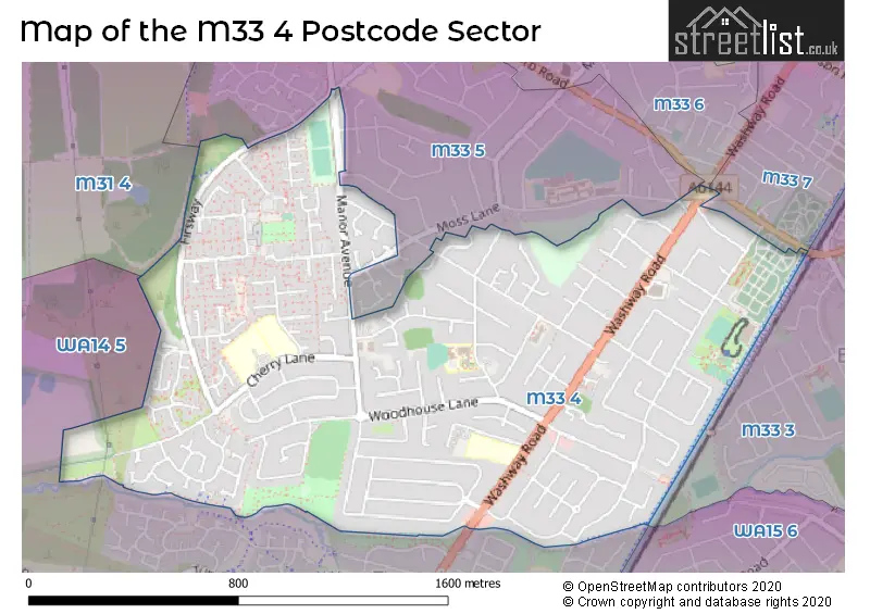
The M33 4 Postcode shares a border with M31 4 (Partington, Carrington), M33 5 (SALE), WA14 5 (Broadheath, West Timperley, Timperley), M33 6 (SALE), M33 7 (SALE) and M33 3 (SALE, Brooklands).
The sector is within the post town of SALE.
M33 4 is a postcode sector within the M33 postcode district which is within the M Manchester postcode area.
The Royal Mail delivery office for the M33 4 postal sector is the Sale Delivery Office.
The area of the M33 4 postcode sector is 1.08 square miles which is 2.80 square kilometres or 692.42 square acres.
Waterways within the M33 4 postcode sector include the Bridgewater Canal.

Map of the M33 4 Postcode Sector
Explore the M33 4 postcode sector by using our free interactive map.
| M | 3 | 3 | - | 4 | X | X |
| M | 3 | 3 | Space | 4 | Letter | Letter |
Official List of Streets
SALE (128 Streets)
Unofficial Streets or Alternative Spellings
Weather Forecast for M33 4
Press Button to Show Forecast for Woodhouses
| Time Period | Icon | Description | Temperature | Rain Probability | Wind |
|---|---|---|---|---|---|
| 03:00 to 06:00 | Partly cloudy (night) | 3.0°C (feels like 2.0°C) | 1.00% | ENE 4 mph | |
| 06:00 to 09:00 | Partly cloudy (day) | 4.0°C (feels like 2.0°C) | 1.00% | ENE 4 mph | |
| 09:00 to 12:00 | Cloudy | 7.0°C (feels like 6.0°C) | 5.00% | ENE 4 mph | |
| 12:00 to 15:00 | Overcast | 9.0°C (feels like 8.0°C) | 9.00% | E 4 mph | |
| 15:00 to 18:00 | Cloudy | 10.0°C (feels like 10.0°C) | 8.00% | E 4 mph | |
| 18:00 to 21:00 | Cloudy | 10.0°C (feels like 9.0°C) | 7.00% | ENE 4 mph | |
| 21:00 to 00:00 | Partly cloudy (night) | 6.0°C (feels like 4.0°C) | 4.00% | ENE 7 mph |
Press Button to Show Forecast for Woodhouses
| Time Period | Icon | Description | Temperature | Rain Probability | Wind |
|---|---|---|---|---|---|
| 00:00 to 03:00 | Partly cloudy (night) | 4.0°C (feels like 2.0°C) | 5.00% | ENE 4 mph | |
| 03:00 to 06:00 | Partly cloudy (night) | 3.0°C (feels like 1.0°C) | 6.00% | ENE 4 mph | |
| 06:00 to 09:00 | Partly cloudy (day) | 5.0°C (feels like 3.0°C) | 6.00% | ENE 4 mph | |
| 09:00 to 12:00 | Cloudy | 8.0°C (feels like 7.0°C) | 8.00% | E 7 mph | |
| 12:00 to 15:00 | Overcast | 10.0°C (feels like 9.0°C) | 16.00% | E 7 mph | |
| 15:00 to 18:00 | Cloudy | 11.0°C (feels like 9.0°C) | 18.00% | ENE 9 mph | |
| 18:00 to 21:00 | Cloudy | 10.0°C (feels like 8.0°C) | 15.00% | ENE 9 mph | |
| 21:00 to 00:00 | Cloudy | 8.0°C (feels like 5.0°C) | 17.00% | NE 9 mph |
Press Button to Show Forecast for Woodhouses
| Time Period | Icon | Description | Temperature | Rain Probability | Wind |
|---|---|---|---|---|---|
| 00:00 to 03:00 | Cloudy | 6.0°C (feels like 4.0°C) | 16.00% | NE 9 mph | |
| 03:00 to 06:00 | Cloudy | 6.0°C (feels like 4.0°C) | 21.00% | NNE 9 mph | |
| 06:00 to 09:00 | Overcast | 7.0°C (feels like 4.0°C) | 23.00% | NNE 9 mph | |
| 09:00 to 12:00 | Light rain | 8.0°C (feels like 5.0°C) | 50.00% | NNE 11 mph | |
| 12:00 to 15:00 | Heavy rain | 9.0°C (feels like 6.0°C) | 76.00% | N 11 mph | |
| 15:00 to 18:00 | Light rain | 10.0°C (feels like 7.0°C) | 57.00% | NNE 9 mph | |
| 18:00 to 21:00 | Cloudy | 10.0°C (feels like 8.0°C) | 19.00% | N 9 mph | |
| 21:00 to 00:00 | Partly cloudy (night) | 8.0°C (feels like 6.0°C) | 10.00% | NW 7 mph |
Schools and Places of Education Within the M33 4 Postcode Sector
Brentwood Community College
Special post 16 institution
Cherry Lane, Sale, , M33 4GY
Head: Ms Judith Lomas
Ofsted Rating: Good
Inspection: 2022-06-23 (673 days ago)
Website: Visit Brentwood Community College Website
Phone: 01619052371
Number of Pupils: 0
Brentwood School
Community special school
Cherry Lane, Sale, Cheshire, M33 4GY
Head: Ms Judith Lomas
Ofsted Rating: Outstanding
Inspection: 2019-06-27 (1765 days ago)
Website: Visit Brentwood School Website
Phone: 01619052371
Number of Pupils: 137
St Margaret Ward Catholic Primary School
Voluntary aided school
Cherry Lane, Sale, Cheshire, M33 4GY
Head: Mr Jason Hughes
Ofsted Rating: Good
Inspection: 2023-11-22 (156 days ago)
Website: Visit St Margaret Ward Catholic Primary School Website
Phone: 01619699852
Number of Pupils: 230
Woodheys Primary School
Community school
Meadway, Sale, Cheshire, M33 4PG
Head: Mr Jon Beisly
Ofsted Rating: Good
Inspection: 2022-12-14 (499 days ago)
Website: Visit Woodheys Primary School Website
Phone: 01619734478
Number of Pupils: 496
House Prices in the M33 4 Postcode Sector
| Type of Property | 2018 Average | 2018 Sales | 2017 Average | 2017 Sales | 2016 Average | 2016 Sales | 2015 Average | 2015 Sales |
|---|---|---|---|---|---|---|---|---|
| Detached | £449,533 | 47 | £463,872 | 43 | £448,523 | 40 | £385,424 | 41 |
| Semi-Detached | £323,346 | 89 | £319,380 | 111 | £282,205 | 105 | £262,702 | 107 |
| Terraced | £178,030 | 15 | £145,719 | 16 | £144,125 | 16 | £152,844 | 16 |
| Flats | £121,833 | 15 | £114,196 | 25 | £122,269 | 20 | £108,694 | 32 |
Important Postcodes M33 4 in the Postcode Sector
M33 4BR is the postcode for Firsway Health Centre, 121 Firs Way
M33 4GT is the postcode for Ascot House, Ascot Avenue, and Ascot House, Ascot Avenue, Sale
M33 4GY is the postcode for St Margaret Ward Catholic Primary School, Cherry Lane, Brentwood High School & Community College, Cherry Lane, and St. Margarets Ward RC Primary School, Cherry Lane
M33 4HE is the postcode for Tyntesfield Primary School, Alma Road, and Tyntesfield Cp School, Alma Road
M33 4ND is the postcode for Trafford Council, Coppice Library, Coppice Avenue
M33 4PG is the postcode for Woodheys Primary School, Meadway
M33 4PS is the postcode for Meadway Health Centre, Meadway
M33 4QW is the postcode for Sale West Youth Centre, Newbury Avenue, and Sale West Community Centre, Newbury Avenue
| The M33 4 Sector is within these Local Authorities |
|
|---|---|
| The M33 4 Sector is within these Counties |
|
| The M33 4 Sector is within these Water Company Areas |
|