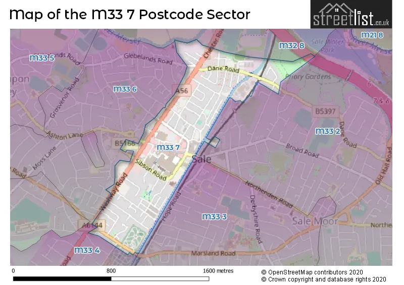
The M33 7 postcode sector is within the county of Greater Manchester.
Did you know? According to the 2021 Census, the M33 7 postcode sector is home to a bustling 5,288 residents!
Given that each sector allows for 400 unique postcode combinations. Letters C, I, K, M, O and V are not allowed in the last two letters of a postcode. With 186 postcodes already in use, this leaves 214 units available.
The M33 7 postal code covers the settlement of SALE.
The M33 7 Postcode shares a border with M32 8 (Stretford), M33 2 (SALE), M33 6 (SALE), M33 3 (SALE, Brooklands) and M33 4 (SALE).
The sector is within the post town of SALE.
M33 7 is a postcode sector within the M33 postcode district which is within the M Manchester postcode area.
The Royal Mail delivery office for the M33 7 postal sector is the Sale Delivery Office.
The area of the M33 7 postcode sector is 0.37 square miles which is 0.96 square kilometres or 238.22 square acres.
The M33 7 postcode sector is crossed by the M60 motorway.
Waterways within the M33 7 postcode sector include the River Mersey, Bridgewater Canal.

Map of the M33 7 Postcode Sector
Explore the M33 7 postcode sector by using our free interactive map.
| M | 3 | 3 | - | 7 | X | X |
| M | 3 | 3 | Space | 7 | Letter | Letter |
Official List of Streets
SALE (82 Streets)
Unofficial Streets or Alternative Spellings
Old Trafford
CHESTER ROADSALE
ASHTON LANE ATKINSON ROAD BRITANNIA ROAD CRANFORD AVENUE GLEBELANDS ROAD MERSEY ROAD OAKFIELD PARK AVENUE WALTON ROAD WHARF ROAD WINSTANLEY ROAD BRIDGEWATER WAY CHAPEL WALKS CHERRY COURT CROSSFORD COURT LORD KITCHENER COURT MAPLE COURT MOORSIDE COURT ROEBUCK GARDENS THE MALL WHITES BRIDGE WILSON STREETWeather Forecast for M33 7
Press Button to Show Forecast for Sale
| Time Period | Icon | Description | Temperature | Rain Probability | Wind |
|---|---|---|---|---|---|
| 18:00 to 21:00 | Cloudy | 22.0°C (feels like 22.0°C) | 3.00% | ESE 4 mph | |
| 21:00 to 00:00 | Partly cloudy (night) | 19.0°C (feels like 18.0°C) | 0.00% | ESE 4 mph |
Press Button to Show Forecast for Sale
| Time Period | Icon | Description | Temperature | Rain Probability | Wind |
|---|---|---|---|---|---|
| 00:00 to 03:00 | Cloudy | 17.0°C (feels like 16.0°C) | 3.00% | ESE 4 mph | |
| 03:00 to 06:00 | Cloudy | 15.0°C (feels like 15.0°C) | 3.00% | E 4 mph | |
| 06:00 to 09:00 | Cloudy | 16.0°C (feels like 16.0°C) | 3.00% | ESE 4 mph | |
| 09:00 to 12:00 | Partly cloudy (day) | 19.0°C (feels like 19.0°C) | 0.00% | SE 4 mph | |
| 12:00 to 15:00 | Partly cloudy (day) | 22.0°C (feels like 20.0°C) | 1.00% | SSE 9 mph | |
| 15:00 to 18:00 | Cloudy | 23.0°C (feels like 21.0°C) | 4.00% | SSE 9 mph | |
| 18:00 to 21:00 | Cloudy | 22.0°C (feels like 20.0°C) | 3.00% | SE 9 mph | |
| 21:00 to 00:00 | Cloudy | 18.0°C (feels like 17.0°C) | 4.00% | ESE 9 mph |
Press Button to Show Forecast for Sale
| Time Period | Icon | Description | Temperature | Rain Probability | Wind |
|---|---|---|---|---|---|
| 00:00 to 03:00 | Cloudy | 16.0°C (feels like 15.0°C) | 4.00% | ESE 9 mph | |
| 03:00 to 06:00 | Cloudy | 14.0°C (feels like 13.0°C) | 3.00% | ESE 7 mph | |
| 06:00 to 09:00 | Cloudy | 15.0°C (feels like 14.0°C) | 3.00% | E 7 mph | |
| 09:00 to 12:00 | Cloudy | 18.0°C (feels like 17.0°C) | 3.00% | ESE 7 mph | |
| 12:00 to 15:00 | Cloudy | 21.0°C (feels like 19.0°C) | 9.00% | SE 9 mph | |
| 15:00 to 18:00 | Light rain shower (day) | 21.0°C (feels like 19.0°C) | 40.00% | SSE 11 mph | |
| 18:00 to 21:00 | Heavy rain shower (day) | 18.0°C (feels like 18.0°C) | 60.00% | S 7 mph | |
| 21:00 to 00:00 | Light rain shower (night) | 16.0°C (feels like 16.0°C) | 34.00% | SE 7 mph |
Press Button to Show Forecast for Sale
| Time Period | Icon | Description | Temperature | Rain Probability | Wind |
|---|---|---|---|---|---|
| 00:00 to 03:00 | Partly cloudy (night) | 15.0°C (feels like 15.0°C) | 11.00% | SSE 4 mph | |
| 03:00 to 06:00 | Partly cloudy (night) | 14.0°C (feels like 13.0°C) | 10.00% | SSE 4 mph | |
| 06:00 to 09:00 | Cloudy | 14.0°C (feels like 13.0°C) | 12.00% | SSE 7 mph | |
| 09:00 to 12:00 | Cloudy | 15.0°C (feels like 14.0°C) | 16.00% | SSE 9 mph | |
| 12:00 to 15:00 | Light rain shower (day) | 17.0°C (feels like 15.0°C) | 44.00% | SSE 11 mph | |
| 15:00 to 18:00 | Heavy rain | 17.0°C (feels like 15.0°C) | 78.00% | SSE 11 mph | |
| 18:00 to 21:00 | Heavy rain | 16.0°C (feels like 14.0°C) | 81.00% | SSE 11 mph | |
| 21:00 to 00:00 | Heavy rain | 14.0°C (feels like 12.0°C) | 75.00% | SSE 9 mph |
Press Button to Show Forecast for Sale
| Time Period | Icon | Description | Temperature | Rain Probability | Wind |
|---|---|---|---|---|---|
| 00:00 to 03:00 | Light rain | 13.0°C (feels like 11.0°C) | 49.00% | SSE 9 mph | |
| 03:00 to 06:00 | Cloudy | 12.0°C (feels like 11.0°C) | 13.00% | SE 9 mph | |
| 06:00 to 09:00 | Cloudy | 12.0°C (feels like 11.0°C) | 8.00% | SE 9 mph | |
| 09:00 to 12:00 | Light rain shower (day) | 14.0°C (feels like 12.0°C) | 36.00% | SSE 11 mph | |
| 12:00 to 15:00 | Light rain shower (day) | 16.0°C (feels like 13.0°C) | 37.00% | SSE 13 mph | |
| 15:00 to 18:00 | Light rain shower (day) | 16.0°C (feels like 13.0°C) | 40.00% | SSE 13 mph | |
| 18:00 to 21:00 | Light rain shower (day) | 15.0°C (feels like 13.0°C) | 37.00% | S 11 mph | |
| 21:00 to 00:00 | Light rain shower (night) | 13.0°C (feels like 11.0°C) | 31.00% | SSE 9 mph |
Schools and Places of Education Within the M33 7 Postcode Sector
Springfield Primary School
Community school
Springfield Road, Sale, Cheshire, M33 7XS
Head: Mrs A J Chard
Ofsted Rating: Outstanding
Inspection: 2021-11-17 (905 days ago)
Website: Visit Springfield Primary School Website
Phone: 01619734149
Number of Pupils: 678
House Prices in the M33 7 Postcode Sector
| Type of Property | 2018 Average | 2018 Sales | 2017 Average | 2017 Sales | 2016 Average | 2016 Sales | 2015 Average | 2015 Sales |
|---|---|---|---|---|---|---|---|---|
| Detached | £415,000 | 4 | £403,750 | 4 | £353,750 | 4 | £320,000 | 2 |
| Semi-Detached | £296,008 | 22 | £294,554 | 18 | £263,663 | 24 | £251,513 | 16 |
| Terraced | £244,625 | 71 | £221,373 | 73 | £211,735 | 62 | £183,340 | 80 |
| Flats | £168,270 | 54 | £140,828 | 91 | £174,784 | 37 | £149,714 | 21 |
Important Postcodes M33 7 in the Postcode Sector
M33 7BH is the postcode for One Stop Resource Centre, Units 1&2
M33 7BP is the postcode for Boat House Rowing Club, The University of Manchester
M33 7DF is the postcode for Trafford C A M H S, 1 Oriel Court
M33 7DZ is the postcode for Trafford Music Service, The Claremont Centre, Claremont Road
M33 7EG is the postcode for Chapel Road Clinic, 70 Chapel Road
M33 7ER is the postcode for Driver and Vehicle Standards Agency, 36-38 Poplar Grove
M33 7NR is the postcode for Magistrates Court, Ashton Lane
M33 7NT is the postcode for MAIN BUILDING, Greater Manchester Fire & Rescue Service, Fire Station, Cranleigh Drive
M33 7SF is the postcode for Trafford Metropolitan Borough Council, Friars Court, Sibson Road
M33 7SS is the postcode for Washway Road Medical Centre, 63-67 Washway Road
M33 7XS is the postcode for Springfield Primary School, Springfield Road
M33 7ZF is the postcode for Trafford Metropolitan Borough Council, Town Hall, 1 Waterside Plaza
| The M33 7 Sector is within these Local Authorities |
|
|---|---|
| The M33 7 Sector is within these Counties |
|
| The M33 7 Sector is within these Water Company Areas |
|