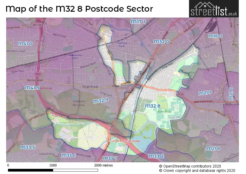
The M32 8 postcode sector is within the county of Greater Manchester.
Did you know? According to the 2021 Census, the M32 8 postcode sector is home to a bustling 7,525 residents!
Given that each sector allows for 400 unique postcode combinations. Letters C, I, K, M, O and V are not allowed in the last two letters of a postcode. With 172 postcodes already in use, this leaves 228 units available.
The M32 8 postal code covers the settlement of Stretford.
The M32 8 Postcode shares a border with M16 0 (MANCHESTER, Old Trafford, Firswood), M32 9 (Stretford), M33 2 (SALE), M33 5 (SALE), M41 9 (Urmston), M33 6 (SALE), M21 8 (MANCHESTER, Chorlton Cum Hardy), M21 9 (MANCHESTER, Chorlton Cum Hardy), M33 7 (SALE) and M32 0 (Stretford).
The sector is within the post town of MANCHESTER.
M32 8 is a postcode sector within the M32 postcode district which is within the M Manchester postcode area.
The Royal Mail delivery office for the M32 8 postal sector is the Stretford Delivery Office.
The area of the M32 8 postcode sector is 1.39 square miles which is 3.60 square kilometres or 889.31 square acres.
The M32 8 postcode sector is crossed by the M60 motorway.
Waterways within the M32 8 postcode sector include the River Mersey, Chorlton Brook.

Map of the M32 8 Postcode Sector
Explore the M32 8 postcode sector by using our free interactive map.
| M | 3 | 2 | - | 8 | X | X |
| M | 3 | 2 | Space | 8 | Letter | Letter |
Official List of Streets
Stretford (79 Streets)
Unofficial Streets or Alternative Spellings
Stretford
BARTON DOCK ROAD CHAPEL LANE DAVYHULME ROAD DELAMERE AVENUE DORSET STREET GRANGE AVENUE HAMPSON ROAD MARLBOROUGH ROAD NEW BELVEDERE CLOSE RADSTOCK ROAD STEPHENSON ROAD STOTHARD ROAD SYDNEY STREET VICTORIA ROADOld Trafford
CHESTER ROAD KINGS ROAD BARFOOT AQUEDUCT BARFOOT BRIDGE BEECH AVENUE BRIDGEWATER STREET BRIDGEWATER WAY BUTLER COURT CARRINGTON SPUR CARRINGTON SPUR ROUNDABOUT COW LANE CROSS STREET CUT HOLE AQUEDUCT EBOR HOUSE EDGEHILL COURT HAWTHORN ROAD CYCLE BYPASS LONGFORD COTTAGES METROLINK PATH NEWHOLME COURT NORWOOD COURT PARKVIEW COURT PERIMETER PATH: SALE WATER PARK PRICHARD STREET STRAND COURT STRETFORD 4 SUNNYSIDE THE HAWTHORNS THE HIGHLANDS THE QUADRANT TRANS PENNINE TRAIL VINE COURTSALE
CROSS STREETTrafford Park
MOSLEY ROADFirswood
RUTLAND AVENUEMANCHESTER
HAWTHORN LANE HEADINGLEY DRIVE TRENT BRIDGE WALKWeather Forecast for M32 8
Press Button to Show Forecast for Stretford
| Time Period | Icon | Description | Temperature | Rain Probability | Wind |
|---|---|---|---|---|---|
| 18:00 to 21:00 | Cloudy | 22.0°C (feels like 20.0°C) | 3.00% | SE 9 mph | |
| 21:00 to 00:00 | Cloudy | 18.0°C (feels like 16.0°C) | 3.00% | ESE 11 mph |
Press Button to Show Forecast for Stretford
| Time Period | Icon | Description | Temperature | Rain Probability | Wind |
|---|---|---|---|---|---|
| 00:00 to 03:00 | Cloudy | 16.0°C (feels like 15.0°C) | 3.00% | ESE 9 mph | |
| 03:00 to 06:00 | Cloudy | 15.0°C (feels like 14.0°C) | 3.00% | ENE 4 mph | |
| 06:00 to 09:00 | Cloudy | 15.0°C (feels like 14.0°C) | 4.00% | ENE 4 mph | |
| 09:00 to 12:00 | Cloudy | 19.0°C (feels like 18.0°C) | 3.00% | ESE 7 mph | |
| 12:00 to 15:00 | Cloudy | 22.0°C (feels like 20.0°C) | 8.00% | SE 11 mph | |
| 15:00 to 18:00 | Light rain shower (day) | 23.0°C (feels like 20.0°C) | 34.00% | SE 11 mph | |
| 18:00 to 21:00 | Light rain shower (day) | 21.0°C (feels like 20.0°C) | 44.00% | SSE 7 mph | |
| 21:00 to 00:00 | Cloudy | 18.0°C (feels like 17.0°C) | 16.00% | SE 7 mph |
Press Button to Show Forecast for Stretford
| Time Period | Icon | Description | Temperature | Rain Probability | Wind |
|---|---|---|---|---|---|
| 00:00 to 03:00 | Partly cloudy (night) | 16.0°C (feels like 16.0°C) | 13.00% | SE 7 mph | |
| 03:00 to 06:00 | Partly cloudy (night) | 14.0°C (feels like 14.0°C) | 10.00% | SSE 4 mph | |
| 06:00 to 09:00 | Cloudy | 14.0°C (feels like 13.0°C) | 11.00% | SSE 7 mph | |
| 09:00 to 12:00 | Cloudy | 16.0°C (feels like 14.0°C) | 11.00% | SSE 11 mph | |
| 12:00 to 15:00 | Cloudy | 17.0°C (feels like 15.0°C) | 16.00% | SSE 13 mph | |
| 15:00 to 18:00 | Cloudy | 17.0°C (feels like 15.0°C) | 22.00% | SSE 13 mph | |
| 18:00 to 21:00 | Light rain | 15.0°C (feels like 13.0°C) | 57.00% | SE 11 mph | |
| 21:00 to 00:00 | Heavy rain | 14.0°C (feels like 13.0°C) | 79.00% | SE 11 mph |
Press Button to Show Forecast for Stretford
| Time Period | Icon | Description | Temperature | Rain Probability | Wind |
|---|---|---|---|---|---|
| 00:00 to 03:00 | Light rain | 14.0°C (feels like 12.0°C) | 56.00% | SE 11 mph | |
| 03:00 to 06:00 | Light rain | 13.0°C (feels like 12.0°C) | 53.00% | SE 9 mph | |
| 06:00 to 09:00 | Light rain | 13.0°C (feels like 11.0°C) | 50.00% | SE 9 mph | |
| 09:00 to 12:00 | Light rain | 14.0°C (feels like 13.0°C) | 52.00% | SE 11 mph | |
| 12:00 to 15:00 | Light rain shower (day) | 16.0°C (feels like 14.0°C) | 42.00% | SSE 11 mph | |
| 15:00 to 18:00 | Heavy rain shower (day) | 17.0°C (feels like 15.0°C) | 59.00% | SSE 11 mph | |
| 18:00 to 21:00 | Light rain shower (day) | 16.0°C (feels like 14.0°C) | 40.00% | SSE 9 mph | |
| 21:00 to 00:00 | Partly cloudy (night) | 14.0°C (feels like 12.0°C) | 11.00% | SSE 9 mph |
Press Button to Show Forecast for Stretford
| Time Period | Icon | Description | Temperature | Rain Probability | Wind |
|---|---|---|---|---|---|
| 00:00 to 03:00 | Partly cloudy (night) | 12.0°C (feels like 11.0°C) | 5.00% | SSE 9 mph | |
| 03:00 to 06:00 | Clear night | 12.0°C (feels like 10.0°C) | 5.00% | SE 9 mph | |
| 06:00 to 09:00 | Partly cloudy (day) | 12.0°C (feels like 10.0°C) | 6.00% | SSE 9 mph | |
| 09:00 to 12:00 | Light rain shower (day) | 14.0°C (feels like 12.0°C) | 34.00% | SSE 11 mph | |
| 12:00 to 15:00 | Light rain shower (day) | 16.0°C (feels like 14.0°C) | 40.00% | SSE 11 mph | |
| 15:00 to 18:00 | Light rain shower (day) | 17.0°C (feels like 14.0°C) | 39.00% | SSE 11 mph | |
| 18:00 to 21:00 | Light rain shower (day) | 16.0°C (feels like 14.0°C) | 40.00% | S 9 mph | |
| 21:00 to 00:00 | Clear night | 14.0°C (feels like 12.0°C) | 8.00% | S 7 mph |
Schools and Places of Education Within the M32 8 Postcode Sector
St Ann's RC Primary School
Voluntary aided school
Derbyshire Lane, Manchester, , M32 8SH
Head: Mrs Maria Noctor
Ofsted Rating: Good
Inspection: 2020-02-26 (1536 days ago)
Website: Visit St Ann's RC Primary School Website
Phone: 01618657705
Number of Pupils: 430
Stretford Grammar School
Foundation school
Granby Road, Manchester, Greater Manchester, M32 8JB
Head: Mr Michael Mullins
Ofsted Rating: Good
Inspection: 2019-02-19 (1908 days ago)
Website: Visit Stretford Grammar School Website
Phone: 01618652293
Number of Pupils: 949
Victoria Park Infant School
Community school
Henshaw Street, Manchester, , M32 8BU
Head: Headteacher Deborah Vrlec
Ofsted Rating: Good
Inspection: 2022-12-07 (521 days ago)
Website: Visit Victoria Park Infant School Website
Phone: 01618654778
Number of Pupils: 211
House Prices in the M32 8 Postcode Sector
| Type of Property | 2018 Average | 2018 Sales | 2017 Average | 2017 Sales | 2016 Average | 2016 Sales | 2015 Average | 2015 Sales |
|---|---|---|---|---|---|---|---|---|
| Detached | £381,071 | 7 | £374,683 | 6 | £310,081 | 8 | £303,283 | 9 |
| Semi-Detached | £291,844 | 39 | £253,051 | 48 | £250,074 | 38 | £244,686 | 59 |
| Terraced | £216,070 | 35 | £225,694 | 47 | £179,006 | 47 | £166,576 | 45 |
| Flats | £137,197 | 7 | £106,646 | 12 | £104,479 | 24 | £96,996 | 14 |
Important Postcodes M32 8 in the Postcode Sector
M32 8AP is the postcode for Trafford Metropolitan Borough Council, Stretford Library, Kingsway, Stretford, Trafford Metropolitan Borough Council, Stretford Library, Kingsway, and STRETFORD LIBRARY, KINGSWAY, STRETFORD
M32 8BU is the postcode for Victoria Park Infant School, Henshaw Street, Stretford, and Victoria Park Infant School, Henshaw Street
M32 8JB is the postcode for Stretford Grammar School, Granby Road, Main Building, Stretford Grammar School, Granby Road, and ATRIUM BUILDING, Stretford Grammar School, Granby Road
M32 8LG is the postcode for National Probation Service, Newton Street
M32 8PR is the postcode for Longford Park Primary School, Cromwell Road, and Longford Park School, 74 Cromwell Road, Stretford
M32 8RJ is the postcode for Greater Manchester Fire & Rescue Service, Fire Station, 246-248 Park Road, Stretford, and Greater Manchester Fire & Rescue Service, Fire Station, 246-248 Park Road
M32 8SH is the postcode for St. Anns RC Primary School, Derbyshire Lane, JUNIOR SCHOOL, St. Anns RC Primary School, Derbyshire Lane, and INFANT & NURSERY SCHOOL, St. Anns RC Primary School, Derbyshire Lane
| The M32 8 Sector is within these Local Authorities |
|
|---|---|
| The M32 8 Sector is within these Counties |
|
| The M32 8 Sector is within these Water Company Areas |
|