The M21 9 postcode sector is within the county of Greater Manchester.
Did you know? According to the 2021 Census, the M21 9 postcode sector is home to a bustling 8,633 residents!
Given that each sector allows for 400 unique postcode combinations. Letters C, I, K, M, O and V are not allowed in the last two letters of a postcode. With 227 postcodes already in use, this leaves 173 units available.
The largest settlements in the M21 9 postal code are MANCHESTER and Chorlton Cum Hardy.
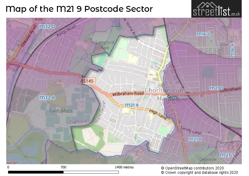
The M21 9 Postcode shares a border with M16 0 (MANCHESTER, Old Trafford, Firswood), M32 8 (Stretford), M21 0 (MANCHESTER, Chorlton Cum Hardy) and M21 8 (MANCHESTER, Chorlton Cum Hardy).
The sector is within the post town of MANCHESTER.
M21 9 is a postcode sector within the M21 postcode district which is within the M Manchester postcode area.
The Royal Mail delivery office for the M21 9 postal sector is the Chorlton Delivery Office.
The area of the M21 9 postcode sector is 0.54 square miles which is 1.41 square kilometres or 347.21 square acres.
Waterways within the M21 9 postcode sector include the Chorlton Brook.

Map of the M21 9 Postcode Sector
Explore the M21 9 postcode sector by using our free interactive map.
| M | 2 | 1 | - | 9 | X | X |
| M | 2 | 1 | Space | 9 | Letter | Letter |
Official List of Streets
MANCHESTER (83 Streets)
Chorlton Cum Hardy (10 Streets)
Unofficial Streets or Alternative Spellings
Chorlton Cum Hardy
BRANTINGHAM ROAD WARWICK ROADMANCHESTER
ALBANY ROAD BARLOW MOOR ROAD BEAUMONT ROAD EDWARD CHARLTON ROAD KEPPEL ROAD LAWNGREEN AVENUE SELBORNE ROAD WILLASTON CLOSE ACRES PASSAGE ALDERFIELD HOUSE BEECH MEWS GRESFORD CLOSE MAIDSTONE MEWS MCLAREN COURT MEADOW COURT NO. 1 PASSGE NO. 3 PASSAGE NO. 7 PASSAGEFirswood
RYE BANK ROADStretford
EDGE LANE GREAT STONE ROADWeather Forecast for M21 9
Press Button to Show Forecast for Chorlton-Cum-Hardy
| Time Period | Icon | Description | Temperature | Rain Probability | Wind |
|---|---|---|---|---|---|
| 03:00 to 06:00 | Cloudy | 12.0°C (feels like 12.0°C) | 5.00% | NE 2 mph | |
| 06:00 to 09:00 | Cloudy | 13.0°C (feels like 12.0°C) | 3.00% | NE 7 mph | |
| 09:00 to 12:00 | Cloudy | 15.0°C (feels like 13.0°C) | 4.00% | ENE 7 mph | |
| 12:00 to 15:00 | Cloudy | 16.0°C (feels like 15.0°C) | 5.00% | ENE 7 mph | |
| 15:00 to 18:00 | Cloudy | 18.0°C (feels like 17.0°C) | 4.00% | ENE 4 mph | |
| 18:00 to 21:00 | Partly cloudy (day) | 18.0°C (feels like 17.0°C) | 0.00% | E 7 mph | |
| 21:00 to 00:00 | Partly cloudy (night) | 15.0°C (feels like 14.0°C) | 0.00% | ESE 4 mph |
Press Button to Show Forecast for Chorlton-Cum-Hardy
| Time Period | Icon | Description | Temperature | Rain Probability | Wind |
|---|---|---|---|---|---|
| 00:00 to 03:00 | Partly cloudy (night) | 12.0°C (feels like 11.0°C) | 0.00% | ESE 4 mph | |
| 03:00 to 06:00 | Cloudy | 11.0°C (feels like 11.0°C) | 3.00% | ESE 4 mph | |
| 06:00 to 09:00 | Cloudy | 12.0°C (feels like 11.0°C) | 4.00% | SE 2 mph | |
| 09:00 to 12:00 | Cloudy | 15.0°C (feels like 14.0°C) | 4.00% | S 7 mph | |
| 12:00 to 15:00 | Cloudy | 18.0°C (feels like 17.0°C) | 8.00% | SSW 7 mph | |
| 15:00 to 18:00 | Cloudy | 19.0°C (feels like 17.0°C) | 12.00% | WSW 7 mph | |
| 18:00 to 21:00 | Cloudy | 16.0°C (feels like 15.0°C) | 5.00% | NW 7 mph | |
| 21:00 to 00:00 | Cloudy | 14.0°C (feels like 14.0°C) | 5.00% | NW 4 mph |
Press Button to Show Forecast for Chorlton-Cum-Hardy
| Time Period | Icon | Description | Temperature | Rain Probability | Wind |
|---|---|---|---|---|---|
| 00:00 to 03:00 | Cloudy | 13.0°C (feels like 13.0°C) | 5.00% | NW 2 mph | |
| 03:00 to 06:00 | Cloudy | 12.0°C (feels like 12.0°C) | 5.00% | WSW 2 mph | |
| 06:00 to 09:00 | Cloudy | 12.0°C (feels like 12.0°C) | 5.00% | SW 2 mph | |
| 09:00 to 12:00 | Cloudy | 15.0°C (feels like 15.0°C) | 5.00% | WSW 4 mph | |
| 12:00 to 15:00 | Cloudy | 18.0°C (feels like 17.0°C) | 4.00% | WNW 4 mph | |
| 15:00 to 18:00 | Cloudy | 19.0°C (feels like 18.0°C) | 4.00% | NW 7 mph | |
| 18:00 to 21:00 | Cloudy | 18.0°C (feels like 17.0°C) | 4.00% | NNW 7 mph | |
| 21:00 to 00:00 | Cloudy | 14.0°C (feels like 14.0°C) | 4.00% | NNW 4 mph |
Press Button to Show Forecast for Chorlton-Cum-Hardy
| Time Period | Icon | Description | Temperature | Rain Probability | Wind |
|---|---|---|---|---|---|
| 00:00 to 03:00 | Cloudy | 12.0°C (feels like 12.0°C) | 4.00% | N 2 mph | |
| 03:00 to 06:00 | Cloudy | 11.0°C (feels like 11.0°C) | 4.00% | NNE 2 mph | |
| 06:00 to 09:00 | Cloudy | 13.0°C (feels like 13.0°C) | 4.00% | E 2 mph | |
| 09:00 to 12:00 | Cloudy | 16.0°C (feels like 16.0°C) | 4.00% | ESE 2 mph | |
| 12:00 to 15:00 | Cloudy | 20.0°C (feels like 19.0°C) | 5.00% | S 4 mph | |
| 15:00 to 18:00 | Cloudy | 21.0°C (feels like 20.0°C) | 7.00% | S 4 mph | |
| 18:00 to 21:00 | Cloudy | 20.0°C (feels like 20.0°C) | 8.00% | S 4 mph | |
| 21:00 to 00:00 | Cloudy | 16.0°C (feels like 16.0°C) | 6.00% | SE 4 mph |
Press Button to Show Forecast for Chorlton-Cum-Hardy
| Time Period | Icon | Description | Temperature | Rain Probability | Wind |
|---|---|---|---|---|---|
| 00:00 to 03:00 | Clear night | 14.0°C (feels like 14.0°C) | 2.00% | SE 4 mph | |
| 03:00 to 06:00 | Clear night | 12.0°C (feels like 12.0°C) | 1.00% | E 4 mph | |
| 06:00 to 09:00 | Sunny day | 13.0°C (feels like 13.0°C) | 1.00% | ESE 4 mph | |
| 09:00 to 12:00 | Sunny day | 18.0°C (feels like 18.0°C) | 1.00% | SSE 4 mph | |
| 12:00 to 15:00 | Partly cloudy (day) | 21.0°C (feels like 19.0°C) | 3.00% | S 7 mph | |
| 15:00 to 18:00 | Partly cloudy (day) | 22.0°C (feels like 20.0°C) | 5.00% | S 9 mph | |
| 18:00 to 21:00 | Partly cloudy (day) | 20.0°C (feels like 19.0°C) | 4.00% | SSW 7 mph | |
| 21:00 to 00:00 | Clear night | 16.0°C (feels like 15.0°C) | 2.00% | SE 4 mph |
Schools and Places of Education Within the M21 9 Postcode Sector
Chorlton CofE Primary School
Voluntary controlled school
Vicars Road, Manchester, , M21 9JA
Head: Mr Philip Trohear
Ofsted Rating: Outstanding
Inspection: 2014-03-14 (3707 days ago)
Website: Visit Chorlton CofE Primary School Website
Phone: 01618816798
Number of Pupils: 223
Oswald Road Primary School
Community school
Oswald Road, Manchester, , M21 9PL
Head: Mrs Deborah Howard
Ofsted Rating: Good
Inspection: 2023-09-28 (222 days ago)
Website: Visit Oswald Road Primary School Website
Phone: 01618814266
Number of Pupils: 665
St John's RC Primary School
Voluntary aided school
Chepstow Road, Manchester, , M21 9SN
Head: Mrs B O'Donoghue
Ofsted Rating: Good
Inspection: 2019-10-09 (1672 days ago)
Website: Visit St John's RC Primary School Website
Phone: 01618811040
Number of Pupils: 394
House Prices in the M21 9 Postcode Sector
| Type of Property | 2018 Average | 2018 Sales | 2017 Average | 2017 Sales | 2016 Average | 2016 Sales | 2015 Average | 2015 Sales |
|---|---|---|---|---|---|---|---|---|
| Detached | £515,000 | 1 | £520,000 | 3 | £540,000 | 2 | £471,625 | 8 |
| Semi-Detached | £436,160 | 44 | £371,636 | 37 | £440,014 | 46 | £368,313 | 51 |
| Terraced | £346,154 | 67 | £326,791 | 71 | £306,764 | 70 | £294,999 | 105 |
| Flats | £176,014 | 36 | £173,771 | 35 | £167,205 | 43 | £140,799 | 42 |
Important Postcodes M21 9 in the Postcode Sector
M21 9BU is the postcode for Graeme House, Wilbraham Road
M21 9JA is the postcode for Chorlton cum Hardy C of E Primary School, Vicars Road, and MAIN SCHOOL, Chorlton cum Hardy C of E Primary School, Vicars Road
M21 9NJ is the postcode for Chorlton Health Centre, 1 Nicolas Road, and Manchester Primary Care Trust, Chorlton Health Centre, 1 Nicolas Road
M21 9PL is the postcode for Oswald Road Primary School, Longford Road, and MAIN SCHOOL, Oswald Road Primary School, Longford Road
M21 9PN is the postcode for Manchester City Council, Chorlton Library, Manchester Road
M21 9PQ is the postcode for Chorlton Leisure Centre, Manchester Road
M21 9SN is the postcode for INFANTS BUILDING, St. Johns RC Primary School, Chepstow Road, St. Johns RC Primary School, Chepstow Road, and JUNIOR BUILDING, St. Johns RC Primary School, Chepstow Road
M21 9SZ is the postcode for Manchester Social Services, 102 Manchester Road
| The M21 9 Sector is within these Local Authorities |
|
|---|---|
| The M21 9 Sector is within these Counties |
|
| The M21 9 Sector is within these Water Company Areas |
|