The M32 0 postcode sector is within the county of Greater Manchester.
Did you know? According to the 2021 Census, the M32 0 postcode sector is home to a bustling 10,573 residents!
Given that each sector allows for 400 unique postcode combinations. Letters C, I, K, M, O and V are not allowed in the last two letters of a postcode. With 283 postcodes already in use, this leaves 117 units available.
The M32 0 postal code covers the settlement of Stretford.
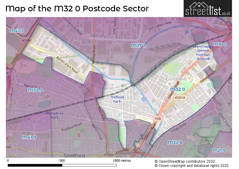
The M32 0 Postcode shares a border with M16 0 (MANCHESTER, Old Trafford, Firswood), M32 8 (Stretford), M32 9 (Stretford), M17 1 (Trafford Park) and M41 7 (Urmston).
The sector is within the post town of MANCHESTER.
M32 0 is a postcode sector within the M32 postcode district which is within the M Manchester postcode area.
The Royal Mail delivery office for the M32 0 postal sector is the Stretford Delivery Office.
The area of the M32 0 postcode sector is 0.96 square miles which is 2.48 square kilometres or 613.83 square acres.
Waterways within the M32 0 postcode sector include the Bridgewater Canal.

Map of the M32 0 Postcode Sector
Explore the M32 0 postcode sector by using our free interactive map.
| M | 3 | 2 | - | 0 | X | X |
| M | 3 | 2 | Space | 0 | Letter | Letter |
Official List of Streets
Stretford (132 Streets)
Unofficial Streets or Alternative Spellings
Stretford
BURLEIGH COURT CYPRUS STREET DERBYSHIRE LANE EDGE LANE JACKSON STREET KINGSWAY LESTER STREET PARK ROAD PRITCHARD STREET RADNOR STREET RALEIGH STREET SCHOOL ROAD TALBOT COURT VICTORIA COURT ALBA WAY BERESFORD COURT BRIDGEWATER STREET BRIDGEWATER WAY BRIGGS ROAD CALEDONIA WAY CHORLEY STREET CLYNE COURT KINGS PARK MUFC FOOTBRIDGE MUNICH TUNNEL PARK WAY PARKWAY TRADING ESTATE PRICHARD STREET SAINT MODWEN ROAD SCHOOL AVENUE ST. PETERS COURT ST. VINCENTS THOMAS STREET FOOTBRIDGE TRAFFORD PARK STATION SUBWAYOld Trafford
CHESTER ROAD TALBOT ROAD WARWICK ROADMANCHESTER
SIR MATT BUSBY WAY TRENT BRIDGE WALKTrafford Park
COMMERCE WAY MOSLEY ROADWeather Forecast for M32 0
Press Button to Show Forecast for Stretford
| Time Period | Icon | Description | Temperature | Rain Probability | Wind |
|---|---|---|---|---|---|
| 00:00 to 03:00 | Partly cloudy (night) | 5.0°C (feels like 3.0°C) | 2.00% | E 4 mph | |
| 03:00 to 06:00 | Partly cloudy (night) | 3.0°C (feels like 2.0°C) | 1.00% | ENE 4 mph | |
| 06:00 to 09:00 | Partly cloudy (day) | 4.0°C (feels like 2.0°C) | 1.00% | ENE 4 mph | |
| 09:00 to 12:00 | Partly cloudy (day) | 7.0°C (feels like 6.0°C) | 2.00% | ENE 4 mph | |
| 12:00 to 15:00 | Cloudy | 9.0°C (feels like 8.0°C) | 9.00% | E 4 mph | |
| 15:00 to 18:00 | Cloudy | 10.0°C (feels like 9.0°C) | 8.00% | E 4 mph | |
| 18:00 to 21:00 | Cloudy | 10.0°C (feels like 9.0°C) | 7.00% | NE 4 mph | |
| 21:00 to 00:00 | Partly cloudy (night) | 6.0°C (feels like 4.0°C) | 4.00% | ENE 7 mph |
Press Button to Show Forecast for Stretford
| Time Period | Icon | Description | Temperature | Rain Probability | Wind |
|---|---|---|---|---|---|
| 00:00 to 03:00 | Partly cloudy (night) | 4.0°C (feels like 2.0°C) | 6.00% | ENE 4 mph | |
| 03:00 to 06:00 | Partly cloudy (night) | 3.0°C (feels like 1.0°C) | 6.00% | ENE 4 mph | |
| 06:00 to 09:00 | Partly cloudy (day) | 5.0°C (feels like 3.0°C) | 6.00% | ENE 4 mph | |
| 09:00 to 12:00 | Cloudy | 8.0°C (feels like 6.0°C) | 8.00% | E 7 mph | |
| 12:00 to 15:00 | Overcast | 10.0°C (feels like 9.0°C) | 16.00% | E 7 mph | |
| 15:00 to 18:00 | Cloudy | 11.0°C (feels like 9.0°C) | 18.00% | ENE 9 mph | |
| 18:00 to 21:00 | Cloudy | 10.0°C (feels like 8.0°C) | 15.00% | ENE 9 mph | |
| 21:00 to 00:00 | Cloudy | 7.0°C (feels like 5.0°C) | 17.00% | NE 9 mph |
Press Button to Show Forecast for Stretford
| Time Period | Icon | Description | Temperature | Rain Probability | Wind |
|---|---|---|---|---|---|
| 00:00 to 03:00 | Cloudy | 6.0°C (feels like 4.0°C) | 16.00% | NE 9 mph | |
| 03:00 to 06:00 | Cloudy | 6.0°C (feels like 4.0°C) | 19.00% | NNE 9 mph | |
| 06:00 to 09:00 | Cloudy | 7.0°C (feels like 4.0°C) | 20.00% | NNE 9 mph | |
| 09:00 to 12:00 | Light rain | 8.0°C (feels like 5.0°C) | 50.00% | NNE 11 mph | |
| 12:00 to 15:00 | Heavy rain | 9.0°C (feels like 6.0°C) | 76.00% | N 11 mph | |
| 15:00 to 18:00 | Light rain | 10.0°C (feels like 7.0°C) | 57.00% | NNE 9 mph | |
| 18:00 to 21:00 | Cloudy | 10.0°C (feels like 8.0°C) | 18.00% | N 9 mph | |
| 21:00 to 00:00 | Partly cloudy (night) | 8.0°C (feels like 6.0°C) | 10.00% | NW 7 mph |
Schools and Places of Education Within the M32 0 Postcode Sector
Gorse Hill Primary School
Community school
Burleigh Road, Manchester, , M32 0PF
Head: Mrs L Bates
Ofsted Rating: Good
Inspection: 2023-11-09 (169 days ago)
Website: Visit Gorse Hill Primary School Website
Phone: 01618651209
Number of Pupils: 373
Stretford High School
Foundation school
Great Stone Road, Manchester, , M32 0XA
Head: Mrs Nicola Doward
Ofsted Rating: Good
Inspection: 2019-12-04 (1605 days ago)
Website: Visit Stretford High School Website
Phone: 01618761850
Number of Pupils: 945
Victoria Park Junior School
Community school
Davyhulme Road East, Manchester, , M32 0XZ
Head: Mr James Wilkinson
Ofsted Rating: Outstanding
Inspection: 2013-10-02 (3859 days ago)
Website: Visit Victoria Park Junior School Website
Phone: 01619125005
Number of Pupils: 241
House Prices in the M32 0 Postcode Sector
| Type of Property | 2018 Average | 2018 Sales | 2017 Average | 2017 Sales | 2016 Average | 2016 Sales | 2015 Average | 2015 Sales |
|---|---|---|---|---|---|---|---|---|
| Detached | £262,000 | 4 | £289,167 | 3 | £200,000 | 4 | £211,333 | 3 |
| Semi-Detached | £213,393 | 58 | £203,470 | 64 | £182,457 | 48 | £165,637 | 81 |
| Terraced | £188,817 | 89 | £166,710 | 76 | £156,484 | 71 | £144,601 | 92 |
| Flats | £114,129 | 42 | £234,228 | 25 | £110,747 | 18 | £91,863 | 27 |
Important Postcodes M32 0 in the Postcode Sector
M32 0AZ is the postcode for Trafford College Technology Centre, Moss Road
M32 0DF is the postcode for Delamere Health Centre, Delamere Avenue, and Delamere Health Centre, Delamere Avenue, Stretford
M32 0LG is the postcode for Trafford Metropolitan Borough Council, Stretford Public Hall, Chester Road
M32 0PF is the postcode for Gorse Hill Primary School, Burleigh Road, and Gorse Hill Primary School, Gorse Hill Primary School, Burleigh Road
M32 0RS is the postcode for A J Bell Ltd, Trafford House, Chester Road
M32 0SL is the postcode for D V L A Local Office, Trafford House, Chester Road
M32 0TH is the postcode for Town Hall, Talbot Road, Trafford Metropolitan Borough Council, Town Hall, Talbot Road, Stretford, TRAFFORD COUNCIL, TOWN HALL, TALBOT ROAD, and Trafford Metropolitan Borough Council, Town Hall, Talbot Road
M32 0UX is the postcode for Greater Manchester Police, Talbot Road, Greater Manchester Police, Talbot Road, Stretford, and Greater Manchester Police, Town Hall, Talbot Road
M32 0XA is the postcode for STRETFORD SPORTS VILLAGE, Stretford High School, Great Stone Road, ATRIUM, Stretford High School, Great Stone Road, Stretford High School, Great Stone Road, and LANGUAGES AND HUMANITIES, Stretford High School, Great Stone Road
M32 0XB is the postcode for Greater Manchester Police, Stretford
M32 0XH is the postcode for Trafford College, Talbot Road
M32 0XZ is the postcode for Victoria Park Junior School, Davyhulme Road East
M32 0ZS is the postcode for STRETFORD LEISURE CENTRE, GREAT STONE ROAD, STRETFORD, Stretford Leisure Centre, Great Stone Road, and Trafford Metropolitan Borough Council, Stretford Leisure Centre, Great Stone Road
| The M32 0 Sector is within these Local Authorities |
|
|---|---|
| The M32 0 Sector is within these Counties |
|
| The M32 0 Sector is within these Water Company Areas |
|