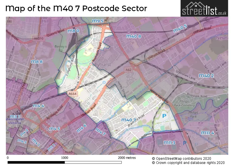
The M40 7 postcode sector is within the county of Greater Manchester.
Did you know? According to the 2021 Census, the M40 7 postcode sector is home to a bustling 6,192 residents!
Given that each sector allows for 400 unique postcode combinations. Letters C, I, K, M, O and V are not allowed in the last two letters of a postcode. With 237 postcodes already in use, this leaves 163 units available.
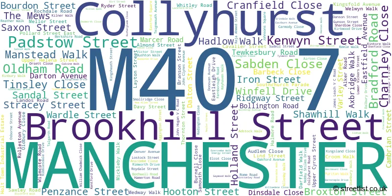
The M40 7 postal code covers the settlement of MANCHESTER.
The M40 7 Postcode shares a border with M4 6 (MANCHESTER), M4 7 (MANCHESTER), M11 3 (MANCHESTER), M11 4 (MANCHESTER, Openshaw, Clayton), M12 6 (MANCHESTER, Ardwick), M4 5 (MANCHESTER), M8 0 (MANCHESTER), M9 5 (MANCHESTER, Harpurhey), M8 8 (MANCHESTER), M4 4 (MANCHESTER), M40 2 (MANCHESTER) and M40 8 (MANCHESTER, Miles Platting).
The sector is within the post town of MANCHESTER.
M40 7 is a postcode sector within the M40 postcode district which is within the M Manchester postcode area.
The Royal Mail delivery office for the M40 7 postal sector is the East Manchester Delivery Office.
The area of the M40 7 postcode sector is 0.72 square miles which is 1.87 square kilometres or 461.78 square acres.
Waterways within the M40 7 postcode sector include the River Medlock, Rochdale Canal, Ashton Canal, River Irk.

Map of the M40 7 Postcode Sector
Explore the M40 7 postcode sector by using our free interactive map.
| M | 4 | 0 | - | 7 | X | X |
| M | 4 | 0 | Space | 7 | Letter | Letter |
Official List of Streets
MANCHESTER (155 Streets)
Collyhurst (2 Streets)
Unofficial Streets or Alternative Spellings
MANCHESTER
ALAN TURING WAY ASHTON NEW ROAD CHURNET STREET COLLYHURST STREET DANTZIC STREET FIR STREET GARFORTH AVENUE HULME HALL LANE JAMES STREET KEELE CLOSE LIVESEY STREET QUEENS ROAD SMEDLEY ROAD STEPHEN HUNT STREET THORNTON STREET NORTH ADSWOOD STREET BACK HAMPSON STREET BARKING STREET BARNEYS STEPS BEECHCROFT CLOSE BERLIZ ROAD BROMLEY STREET SUBWAY COLESHILL STREET COWAN STREET CRINON WALK CYRUS STREET EAST NEWTON STREET ELIZA ANN STREET EXFORD CLOSE FENHAM CLOSE FERDINAND STREET FITZGEORGE STREET FORGE LANE BRIDGE GLEDEN STREET HALESWORTH ROAD HAMPSON STREET HELGA STREET HOLT TOWN INKERMAN STREET JOE MERCER WAY KIRKGATE CLOSE LANSTEAD DRIVE MILLHEAD AVENUE NEW VIADUCT STREET OVERBROOK AVENUE PAGET STREET PHELAN CLOSE RIDGEWAY STREET RIGEL STREET ROYLE BRIDGE SALCOTT WALK SAND STREET SCROPTON STREET SHELLARD ROAD SHENFIELD WALK SHETLAND ROAD SLEAFORD CLOSE SPORTCITY WAY TEER STREET TEIGNMOUTH STREET THORNAGE DRIVE TOPLEY STREET VAUXHALL STREET WESTON STREET WINSCOMBE DRIVEFailsworth
OLDHAM ROADMiles Platting
LORD NORTH STREETWeather Forecast for M40 7
Press Button to Show Forecast for Miles Platting
| Time Period | Icon | Description | Temperature | Rain Probability | Wind |
|---|---|---|---|---|---|
| 15:00 to 18:00 | Cloudy | 23.0°C (feels like 21.0°C) | 17.00% | SE 11 mph | |
| 18:00 to 21:00 | Thunder shower (day) | 21.0°C (feels like 20.0°C) | 65.00% | SE 9 mph | |
| 21:00 to 00:00 | Light rain shower (night) | 18.0°C (feels like 17.0°C) | 36.00% | ENE 7 mph |
Press Button to Show Forecast for Miles Platting
| Time Period | Icon | Description | Temperature | Rain Probability | Wind |
|---|---|---|---|---|---|
| 00:00 to 03:00 | Light rain shower (night) | 16.0°C (feels like 16.0°C) | 29.00% | SSE 4 mph | |
| 03:00 to 06:00 | Partly cloudy (night) | 15.0°C (feels like 15.0°C) | 3.00% | ESE 4 mph | |
| 06:00 to 09:00 | Cloudy | 15.0°C (feels like 15.0°C) | 6.00% | SE 4 mph | |
| 09:00 to 12:00 | Cloudy | 17.0°C (feels like 15.0°C) | 4.00% | S 9 mph | |
| 12:00 to 15:00 | Cloudy | 19.0°C (feels like 17.0°C) | 4.00% | SSE 11 mph | |
| 15:00 to 18:00 | Cloudy | 21.0°C (feels like 17.0°C) | 7.00% | SSE 13 mph | |
| 18:00 to 21:00 | Cloudy | 19.0°C (feels like 16.0°C) | 11.00% | SSE 11 mph | |
| 21:00 to 00:00 | Cloudy | 17.0°C (feels like 15.0°C) | 13.00% | SE 9 mph |
Press Button to Show Forecast for Miles Platting
| Time Period | Icon | Description | Temperature | Rain Probability | Wind |
|---|---|---|---|---|---|
| 00:00 to 03:00 | Light rain | 15.0°C (feels like 14.0°C) | 48.00% | SE 9 mph | |
| 03:00 to 06:00 | Light rain | 14.0°C (feels like 13.0°C) | 54.00% | ESE 9 mph | |
| 06:00 to 09:00 | Light rain | 14.0°C (feels like 13.0°C) | 52.00% | ESE 9 mph | |
| 09:00 to 12:00 | Light rain | 15.0°C (feels like 14.0°C) | 56.00% | ESE 9 mph | |
| 12:00 to 15:00 | Heavy rain shower (day) | 16.0°C (feels like 15.0°C) | 64.00% | ESE 11 mph | |
| 15:00 to 18:00 | Light rain shower (day) | 17.0°C (feels like 15.0°C) | 48.00% | SE 11 mph | |
| 18:00 to 21:00 | Light rain shower (day) | 16.0°C (feels like 15.0°C) | 44.00% | SE 7 mph | |
| 21:00 to 00:00 | Cloudy | 14.0°C (feels like 13.0°C) | 16.00% | SE 7 mph |
Press Button to Show Forecast for Miles Platting
| Time Period | Icon | Description | Temperature | Rain Probability | Wind |
|---|---|---|---|---|---|
| 00:00 to 03:00 | Cloudy | 13.0°C (feels like 12.0°C) | 10.00% | ESE 7 mph | |
| 03:00 to 06:00 | Partly cloudy (night) | 12.0°C (feels like 11.0°C) | 2.00% | ESE 7 mph | |
| 06:00 to 09:00 | Partly cloudy (day) | 13.0°C (feels like 12.0°C) | 3.00% | E 7 mph | |
| 09:00 to 12:00 | Partly cloudy (day) | 16.0°C (feels like 15.0°C) | 7.00% | ESE 9 mph | |
| 12:00 to 15:00 | Light rain shower (day) | 18.0°C (feels like 17.0°C) | 34.00% | SE 9 mph | |
| 15:00 to 18:00 | Light rain shower (day) | 19.0°C (feels like 17.0°C) | 37.00% | SE 9 mph | |
| 18:00 to 21:00 | Light rain shower (day) | 18.0°C (feels like 17.0°C) | 32.00% | SE 7 mph | |
| 21:00 to 00:00 | Clear night | 15.0°C (feels like 14.0°C) | 3.00% | SE 4 mph |
Press Button to Show Forecast for Miles Platting
| Time Period | Icon | Description | Temperature | Rain Probability | Wind |
|---|---|---|---|---|---|
| 00:00 to 03:00 | Clear night | 13.0°C (feels like 13.0°C) | 2.00% | SE 4 mph | |
| 03:00 to 06:00 | Clear night | 12.0°C (feels like 11.0°C) | 2.00% | SE 4 mph | |
| 06:00 to 09:00 | Sunny day | 13.0°C (feels like 13.0°C) | 3.00% | SE 4 mph | |
| 09:00 to 12:00 | Sunny day | 17.0°C (feels like 16.0°C) | 5.00% | SSW 4 mph | |
| 12:00 to 15:00 | Cloudy | 19.0°C (feels like 18.0°C) | 13.00% | SW 4 mph | |
| 15:00 to 18:00 | Light rain shower (day) | 19.0°C (feels like 18.0°C) | 32.00% | WSW 7 mph | |
| 18:00 to 21:00 | Partly cloudy (day) | 19.0°C (feels like 18.0°C) | 9.00% | WSW 7 mph | |
| 21:00 to 00:00 | Clear night | 15.0°C (feels like 15.0°C) | 5.00% | W 7 mph |
Schools and Places of Education Within the M40 7 Postcode Sector
Abbott Community Primary School
Community school
Livesey Street, Manchester, Lancashire, M40 7PR
Head: Miss Phillippa Wilson
Ofsted Rating: Outstanding
Inspection: 2019-01-16 (1943 days ago)
Website: Visit Abbott Community Primary School Website
Phone: 01618349529
Number of Pupils: 239
Collyhurst Nursery School
Local authority nursery school
Teignmouth Avenue, Manchester, Lancashire, M40 7QD
Head: Mr Alexander Reed
Ofsted Rating: Outstanding
Inspection: 2019-09-11 (1705 days ago)
Website: Visit Collyhurst Nursery School Website
Phone: 01612051744
Number of Pupils: 43
Park View Community Primary
Community school
Varley Street, Manchester, , M40 7EJ
Head: Headteacher Sarah Navin
Ofsted Rating: Good
Inspection: 2018-04-26 (2208 days ago)
Website: Visit Park View Community Primary Website
Phone: 01615198562
Number of Pupils: 407
Saviour CofE Primary School
Voluntary aided school
Eggington Street, Manchester, , M40 7RH
Head: Mrs Eileen Anderson
Ofsted Rating: Requires improvement
Inspection: 2023-05-18 (360 days ago)
Website: Visit Saviour CofE Primary School Website
Phone: 01612051221
Number of Pupils: 160
St Malachy's RC Primary School
Voluntary aided school
Eggington Street, Manchester, , M40 7RG
Head: Mrs Janine Parker
Ofsted Rating: Good
Inspection: 2023-05-24 (354 days ago)
Website: Visit St Malachy's RC Primary School Website
Phone: 01612053496
Number of Pupils: 230
House Prices in the M40 7 Postcode Sector
| Type of Property | 2018 Average | 2018 Sales | 2017 Average | 2017 Sales | 2016 Average | 2016 Sales | 2015 Average | 2015 Sales |
|---|---|---|---|---|---|---|---|---|
| Detached | £275,000 | 1 | £135,000 | 1 | £174,300 | 3 | £167,248 | 4 |
| Semi-Detached | £217,006 | 26 | £192,354 | 25 | £139,955 | 12 | £144,637 | 23 |
| Terraced | £179,824 | 44 | £141,451 | 34 | £107,684 | 42 | £112,781 | 32 |
| Flats | £134,400 | 5 | £113,438 | 24 | £112,922 | 38 | £83,929 | 43 |
Important Postcodes M40 7 in the Postcode Sector
M40 7DA is the postcode for Sure Start Childrens Centre, St. Marks C of E Primary School, Holland Street
M40 7EJ is the postcode for Park View Community School, 31 Varley Street
M40 7LJ is the postcode for GF TRAINING SUITE, Victoria Mill, 10 Lower Vickers Street, and VICTORIA MILL PART GROUND FLOOR, Victoria Mill, 10 Lower Vickers Street
M40 7PR is the postcode for Abbott Cp School, Sudell Street
M40 7QD is the postcode for MAIN BUILDING, Collyhurst Nursery School and Surestart, Teignmouth Avenue
M40 7QH is the postcode for Whitley Road Medical Centre, 1 Whitley Road
M40 7RG is the postcode for St. Malachys School, Eggington Street
M40 7RH is the postcode for Saviour C of E Primary School, Eggington Street
| The M40 7 Sector is within these Local Authorities |
|
|---|---|
| The M40 7 Sector is within these Counties |
|
| The M40 7 Sector is within these Water Company Areas |
|