The ME2 1 postcode sector is within the county of Kent.
Did you know? According to the 2021 Census, the ME2 1 postcode sector is home to a bustling 6,605 residents!
Given that each sector allows for 400 unique postcode combinations. Letters C, I, K, M, O and V are not allowed in the last two letters of a postcode. With 152 postcodes already in use, this leaves 248 units available.
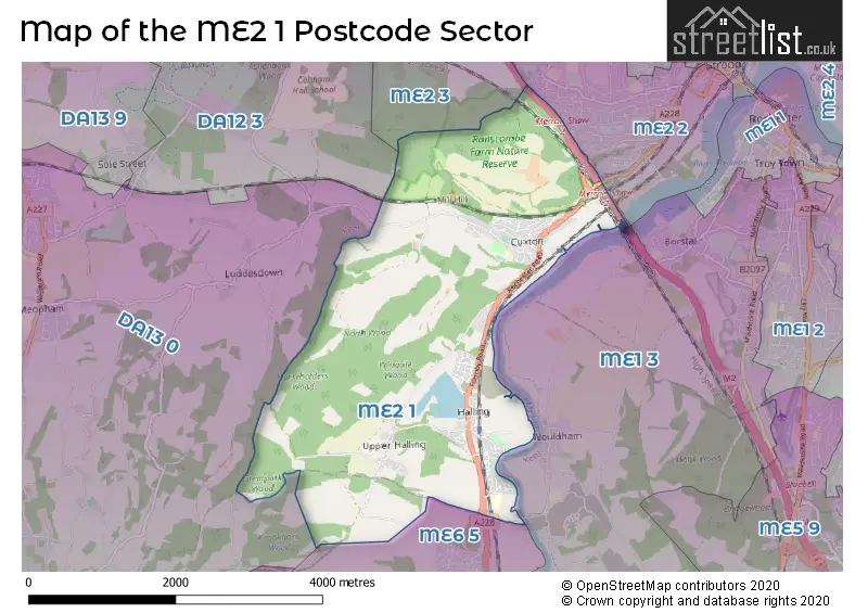
The largest settlement in the ME2 1 postal code is Halling followed by Cuxton, and Upper Halling.
The ME2 1 Postcode shares a border with DA13 0 (Meopham, Vigo, Luddesdown), ME1 3 (ROCHESTER, Wouldham, Burham), ME2 2 (ROCHESTER), ME2 3 (ROCHESTER, Strood), ME6 5 (SNODLAND) and DA12 3 (Shorne, Cobham).
The sector is within the post town of ROCHESTER.
ME2 1 is a postcode sector within the ME2 postcode district which is within the ME Medway postcode area.
The Royal Mail delivery office for the ME2 1 postal sector is the Rochester Delivery Office.
The area of the ME2 1 postcode sector is 6.38 square miles which is 16.54 square kilometres or 4,086.20 square acres.
The ME2 1 postcode sector is crossed by the M2 motorway.
Waterways within the ME2 1 postcode sector include the Medway.

Map of the ME2 1 Postcode Sector
Explore the ME2 1 postcode sector by using our free interactive map.
| M | E | 2 | - | 1 | X | X |
| M | E | 2 | Space | 1 | Letter | Letter |
Official List of Streets
Halling (52 Streets)
Upper Halling (12 Streets)
Cuxton (26 Streets)
Unofficial Streets or Alternative Spellings
Weather Forecast for ME2 1
Press Button to Show Forecast for Strood
| Time Period | Icon | Description | Temperature | Rain Probability | Wind |
|---|---|---|---|---|---|
| 18:00 to 21:00 | Heavy rain | 10.0°C (feels like 7.0°C) | 93.00% | NE 11 mph | |
| 21:00 to 00:00 | Heavy rain | 10.0°C (feels like 7.0°C) | 95.00% | NE 13 mph |
Press Button to Show Forecast for Strood
| Time Period | Icon | Description | Temperature | Rain Probability | Wind |
|---|---|---|---|---|---|
| 00:00 to 03:00 | Heavy rain | 10.0°C (feels like 9.0°C) | 88.00% | E 9 mph | |
| 03:00 to 06:00 | Heavy rain shower (night) | 11.0°C (feels like 9.0°C) | 83.00% | SSE 9 mph | |
| 06:00 to 09:00 | Heavy rain shower (day) | 10.0°C (feels like 8.0°C) | 67.00% | SSW 9 mph | |
| 09:00 to 12:00 | Light rain | 11.0°C (feels like 9.0°C) | 51.00% | SW 11 mph | |
| 12:00 to 15:00 | Light rain | 9.0°C (feels like 6.0°C) | 51.00% | WSW 16 mph | |
| 15:00 to 18:00 | Cloudy | 9.0°C (feels like 6.0°C) | 11.00% | WSW 13 mph | |
| 18:00 to 21:00 | Cloudy | 10.0°C (feels like 8.0°C) | 6.00% | SW 9 mph | |
| 21:00 to 00:00 | Clear night | 8.0°C (feels like 6.0°C) | 1.00% | SSW 9 mph |
Press Button to Show Forecast for Strood
| Time Period | Icon | Description | Temperature | Rain Probability | Wind |
|---|---|---|---|---|---|
| 00:00 to 03:00 | Clear night | 7.0°C (feels like 5.0°C) | 0.00% | SSW 7 mph | |
| 03:00 to 06:00 | Clear night | 6.0°C (feels like 4.0°C) | 0.00% | SSW 7 mph | |
| 06:00 to 09:00 | Sunny day | 7.0°C (feels like 5.0°C) | 0.00% | S 7 mph | |
| 09:00 to 12:00 | Partly cloudy (day) | 12.0°C (feels like 10.0°C) | 0.00% | SSW 11 mph | |
| 12:00 to 15:00 | Partly cloudy (day) | 14.0°C (feels like 12.0°C) | 5.00% | S 11 mph | |
| 15:00 to 18:00 | Sunny day | 15.0°C (feels like 12.0°C) | 3.00% | S 13 mph | |
| 18:00 to 21:00 | Sunny day | 14.0°C (feels like 12.0°C) | 1.00% | S 9 mph | |
| 21:00 to 00:00 | Clear night | 10.0°C (feels like 8.0°C) | 1.00% | SE 7 mph |
Press Button to Show Forecast for Strood
| Time Period | Icon | Description | Temperature | Rain Probability | Wind |
|---|---|---|---|---|---|
| 00:00 to 03:00 | Partly cloudy (night) | 8.0°C (feels like 7.0°C) | 1.00% | SE 4 mph | |
| 03:00 to 06:00 | Partly cloudy (night) | 8.0°C (feels like 7.0°C) | 1.00% | SE 4 mph | |
| 06:00 to 09:00 | Sunny day | 10.0°C (feels like 9.0°C) | 2.00% | SE 7 mph | |
| 09:00 to 12:00 | Cloudy | 14.0°C (feels like 13.0°C) | 5.00% | SE 7 mph | |
| 12:00 to 15:00 | Cloudy | 16.0°C (feels like 14.0°C) | 12.00% | SE 9 mph | |
| 15:00 to 18:00 | Light rain shower (day) | 16.0°C (feels like 14.0°C) | 30.00% | SE 9 mph | |
| 18:00 to 21:00 | Light rain shower (day) | 15.0°C (feels like 14.0°C) | 31.00% | ESE 9 mph | |
| 21:00 to 00:00 | Cloudy | 12.0°C (feels like 11.0°C) | 16.00% | E 7 mph |
Press Button to Show Forecast for Strood
| Time Period | Icon | Description | Temperature | Rain Probability | Wind |
|---|---|---|---|---|---|
| 00:00 to 03:00 | Cloudy | 12.0°C (feels like 11.0°C) | 14.00% | ESE 7 mph | |
| 03:00 to 06:00 | Cloudy | 10.0°C (feels like 9.0°C) | 11.00% | E 4 mph | |
| 06:00 to 09:00 | Cloudy | 11.0°C (feels like 11.0°C) | 11.00% | E 4 mph | |
| 09:00 to 12:00 | Cloudy | 14.0°C (feels like 14.0°C) | 13.00% | ENE 4 mph | |
| 12:00 to 15:00 | Partly cloudy (day) | 17.0°C (feels like 16.0°C) | 12.00% | ENE 7 mph | |
| 15:00 to 18:00 | Cloudy | 18.0°C (feels like 17.0°C) | 10.00% | SE 9 mph | |
| 18:00 to 21:00 | Cloudy | 16.0°C (feels like 15.0°C) | 11.00% | SSE 7 mph | |
| 21:00 to 00:00 | Cloudy | 14.0°C (feels like 13.0°C) | 9.00% | NE 7 mph |
Schools and Places of Education Within the ME2 1 Postcode Sector
Cuxton Community Infant School
Academy converter
Bush Road, Rochester, Kent, ME2 1EY
Head: Mrs Charlotte Aldham Breary
Ofsted Rating: Good
Inspection: 2022-03-30 (759 days ago)
Website: Visit Cuxton Community Infant School Website
Phone: 01634337720
Number of Pupils: 180
Cuxton Community Junior School
Academy sponsor led
Bush Road, Rochester, Kent, ME2 1EY
Head: Mrs Charlotte Aldham Breary
Ofsted Rating: Good
Inspection: 2022-07-07 (660 days ago)
Website: Visit Cuxton Community Junior School Website
Phone: 01634337720
Number of Pupils: 228
Halling Primary School
Academy converter
Howlsmere Close, Rochester, Kent, ME2 1ER
Head: Ms Lisa Taylor
Ofsted Rating: Good
Inspection: 2023-06-07 (325 days ago)
Website: Visit Halling Primary School Website
Phone: 01634240258
Number of Pupils: 376
House Prices in the ME2 1 Postcode Sector
| Type of Property | 2018 Average | 2018 Sales | 2017 Average | 2017 Sales | 2016 Average | 2016 Sales | 2015 Average | 2015 Sales |
|---|---|---|---|---|---|---|---|---|
| Detached | £461,427 | 27 | £409,521 | 43 | £419,519 | 68 | £375,333 | 55 |
| Semi-Detached | £309,057 | 35 | £316,776 | 70 | £291,829 | 38 | £253,408 | 44 |
| Terraced | £247,000 | 33 | £264,212 | 47 | £242,222 | 45 | £223,658 | 41 |
| Flats | £216,188 | 17 | £236,038 | 14 | £210,000 | 2 | £192,912 | 12 |
Important Postcodes ME2 1 in the Postcode Sector
ME2 1ER is the postcode for Halling Primary School, Howlsmere Close, Halling, and Halling Primary School, Howlsmere Close
ME2 1EY is the postcode for Cuxton Community Infant School, Bush Road, and INFANTS & JUNIORS, The Academy of Cuxton Schools, Bush Road
ME2 1EZ is the postcode for Cuxton Community Junior School, Bush Road, and INFANTS & JUNIORS, The Academy of Cuxton Schools, Bush Road
| The ME2 1 Sector is within these Local Authorities |
|
|---|---|
| The ME2 1 Sector is within these Counties |
|
| The ME2 1 Sector is within these Water Company Areas |
|