The ME6 postcode district is a postal district located in the ME Medway postcode area with a population of 11,844 residents according to the 2021 England and Wales Census.
The area of the ME6 postcode district is 2.46 square miles which is 6.37 square kilometres or 1,573.17 acres.
Currently, the ME6 district has about 306 postcode units spread across 1 geographic postcode sectors.
Given that each sector allows for 400 unique postcode combinations, the district has a capacity of 400 postcodes. With 306 postcodes already in use, this leaves 94 units available.
The ME6 postal code covers the settlement of SNODLAND.
The postcode area has a boundary with Thames Estuary.
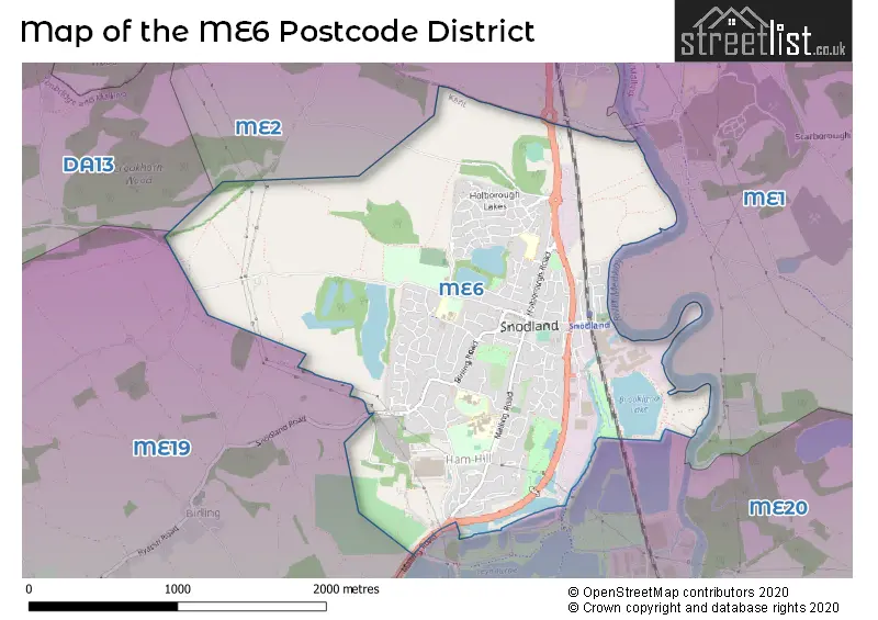
The ME6 Postcode shares a border with ME2 (ROCHESTER, Halling, Strood), ME20 (Larkfield, AYLESFORD, Ditton) and ME1 (ROCHESTER, Wouldham, Burham).
The primary settlement in the ME6 postcode district is Snodland, which is located in the county of Kent, England. Snodland has the highest count of postcodes in this district. There are no other significant settlements mentioned for the ME6 postcode district.
For the district ME6, we have data on 2 postcode sectors. Here's a breakdown: The sector ME6 5, covers Snodland in Kent. The sector ME6 9 is non-geographic. It's often designated for PO Boxes, large organisations, or special services.
ME6 Postcode Sectors

Map of the ME6 Postcode District
Explore the ME6 postcode district by using our free interactive map.
When it comes to local government, postal geography often disregards political borders. However, for a breakdown in the ME6 District: the district mostly encompasses the Tonbridge and Malling District (B) area with a total of 308 postcodes.
Recent House Sales in ME6
| Date | Price | Address |
|---|---|---|
| 20/10/2023 | £185,500 | Bingley Close, Snodland, ME6 5PS |
| 03/10/2023 | £367,500 | Covey Hall Road, Snodland, ME6 5NX |
| 13/09/2023 | £335,000 | Cooper Road, Snodland, ME6 5JH |
| 13/09/2023 | £467,500 | Amisse Drive, Snodland, ME6 5GN |
| 08/09/2023 | £677,000 | Manley Boulevard, Snodland, ME6 5SD |
| 01/09/2023 | £365,000 | Delamere Gardens, Snodland, ME6 5BQ |
| 01/09/2023 | £290,000 | Watts Close, Snodland, ME6 5TA |
| 25/08/2023 | £370,000 | Orchard Way, Snodland, ME6 5EW |
| 24/08/2023 | £300,000 | Coombe Close, Snodland, ME6 5HZ |
| 21/08/2023 | £555,000 | Elder Wood Close, Snodland, ME6 5FH |
Where is the ME6 Postcode District?
The postcode district ME6 is located in SNODLAND. SNODLAND is situated near several towns. AYLESFORD is located to the South East, approximately 2.61 miles away. WEST MALLING is situated to the South, around 3.28 miles away. ROCHESTER is located in the North East, approximately 3.87 miles from SNODLAND. LONGFIELD is situated in the North West, around 6.51 miles away. Additionally, SNODLAND is approximately 27.23 miles distant from the center of London.
The district covers the post towns of AYLESFORD, SNODLAND, WEST MALLING.
The sector has postcodes within the nation of England.
The ME6 Postcode District is in the West Kent region of Kent within the South East (England).
Weather Forecast for ME6
Press Button to Show Forecast for East Malling
| Time Period | Icon | Description | Temperature | Rain Probability | Wind |
|---|---|---|---|---|---|
| 06:00 to 09:00 | Partly cloudy (day) | 9.0°C (feels like 9.0°C) | 1.00% | SSE 2 mph | |
| 09:00 to 12:00 | Sunny day | 14.0°C (feels like 14.0°C) | 0.00% | S 2 mph | |
| 12:00 to 15:00 | Sunny day | 19.0°C (feels like 19.0°C) | 0.00% | SE 4 mph | |
| 15:00 to 18:00 | Partly cloudy (day) | 20.0°C (feels like 20.0°C) | 1.00% | ESE 4 mph | |
| 18:00 to 21:00 | Partly cloudy (day) | 19.0°C (feels like 18.0°C) | 0.00% | SE 7 mph | |
| 21:00 to 00:00 | Clear night | 13.0°C (feels like 13.0°C) | 0.00% | S 2 mph |
Press Button to Show Forecast for East Malling
| Time Period | Icon | Description | Temperature | Rain Probability | Wind |
|---|---|---|---|---|---|
| 00:00 to 03:00 | Clear night | 10.0°C (feels like 10.0°C) | 1.00% | S 2 mph | |
| 03:00 to 06:00 | Cloudy | 9.0°C (feels like 9.0°C) | 4.00% | ESE 0 mph | |
| 06:00 to 09:00 | Cloudy | 11.0°C (feels like 11.0°C) | 4.00% | ENE 0 mph | |
| 09:00 to 12:00 | Cloudy | 17.0°C (feels like 17.0°C) | 4.00% | E 2 mph | |
| 12:00 to 15:00 | Cloudy | 20.0°C (feels like 20.0°C) | 4.00% | ESE 7 mph | |
| 15:00 to 18:00 | Cloudy | 21.0°C (feels like 20.0°C) | 4.00% | ESE 7 mph | |
| 18:00 to 21:00 | Partly cloudy (day) | 19.0°C (feels like 18.0°C) | 1.00% | E 7 mph | |
| 21:00 to 00:00 | Clear night | 14.0°C (feels like 13.0°C) | 0.00% | E 4 mph |
Press Button to Show Forecast for East Malling
| Time Period | Icon | Description | Temperature | Rain Probability | Wind |
|---|---|---|---|---|---|
| 00:00 to 03:00 | Clear night | 12.0°C (feels like 11.0°C) | 0.00% | E 2 mph | |
| 03:00 to 06:00 | Clear night | 10.0°C (feels like 10.0°C) | 1.00% | ENE 2 mph | |
| 06:00 to 09:00 | Sunny day | 13.0°C (feels like 13.0°C) | 1.00% | NE 2 mph | |
| 09:00 to 12:00 | Sunny day | 19.0°C (feels like 19.0°C) | 1.00% | ENE 4 mph | |
| 12:00 to 15:00 | Partly cloudy (day) | 22.0°C (feels like 21.0°C) | 0.00% | ESE 7 mph | |
| 15:00 to 18:00 | Partly cloudy (day) | 22.0°C (feels like 20.0°C) | 1.00% | ESE 9 mph | |
| 18:00 to 21:00 | Sunny day | 20.0°C (feels like 19.0°C) | 0.00% | E 7 mph | |
| 21:00 to 00:00 | Clear night | 15.0°C (feels like 14.0°C) | 0.00% | E 4 mph |
Press Button to Show Forecast for East Malling
| Time Period | Icon | Description | Temperature | Rain Probability | Wind |
|---|---|---|---|---|---|
| 00:00 to 03:00 | Clear night | 13.0°C (feels like 13.0°C) | 0.00% | E 4 mph | |
| 03:00 to 06:00 | Clear night | 12.0°C (feels like 12.0°C) | 1.00% | E 2 mph | |
| 06:00 to 09:00 | Partly cloudy (day) | 15.0°C (feels like 14.0°C) | 2.00% | E 2 mph | |
| 09:00 to 12:00 | Partly cloudy (day) | 20.0°C (feels like 19.0°C) | 2.00% | ESE 4 mph | |
| 12:00 to 15:00 | Cloudy | 22.0°C (feels like 21.0°C) | 7.00% | SE 9 mph | |
| 15:00 to 18:00 | Cloudy | 22.0°C (feels like 21.0°C) | 8.00% | SE 9 mph | |
| 18:00 to 21:00 | Cloudy | 20.0°C (feels like 19.0°C) | 8.00% | SSE 7 mph | |
| 21:00 to 00:00 | Cloudy | 16.0°C (feels like 15.0°C) | 9.00% | SSE 4 mph |
Postcode Sectors within the ME6 District
| Postcode Sector | Delivery Office |
|---|---|
| ME6 5 | Medway Valley Delivery Office |
| M | E | 6 | - | X | X | X |
| M | E | 6 | Space | Numeric | Letter | Letter |
Current Monthly Rental Prices
| # Bedrooms | Min Price | Max Price | Avg Price |
|---|---|---|---|
| £445 | £445 | £445 | |
| 1 | £850 | £950 | £883 |
| 2 | £1,100 | £1,375 | £1,238 |
| 4 | £2,200 | £2,500 | £2,350 |
Current House Prices
| # Bedrooms | Min Price | Max Price | Avg Price |
|---|---|---|---|
| £110,000 | £110,000 | £110,000 | |
| 1 | £190,000 | £280,000 | £214,000 |
| 2 | £165,500 | £350,000 | £247,833 |
| 3 | £230,000 | £450,000 | £350,603 |
| 4 | £281,000 | £625,000 | £460,077 |
| 5 | £460,000 | £725,000 | £578,333 |
Estate Agents who Operate in the ME6 District
| Logo | Name | Brand Name | Address | Contact Number | Total Properties |
|---|---|---|---|---|---|
 | Snodland | Wards | 7 Malling Road, Snodland, Kent, ME6 5AA | 01634 563741 | 30 |
 | Snodland | CWB Property | 48 Holborough Road, Snodland, ME6 5PB | 01634 563477 | 7 |
 | Snodland | KHP Country Homes | 36 High Street, Snodland, ME6 5DA | 01634 214001 | 7 |
 | Worthing | Homewise | 1 Liverpool Gardens Worthing BN11 1TF | 01903 497338 | 6 |
 | West Malling | Hicks Estate Agents | 84 High Street, West Malling, ME19 6NE | 01732 444145 | 5 |
Yearly House Price Averages for the ME6 Postcode District
| Type of Property | 2018 Average | 2018 Sales | 2017 Average | 2017 Sales | 2016 Average | 2016 Sales | 2015 Average | 2015 Sales |
|---|---|---|---|---|---|---|---|---|
| Detached | £449,919 | 40 | £418,003 | 41 | £388,111 | 27 | £365,997 | 19 |
| Semi-Detached | £352,407 | 62 | £301,508 | 95 | £288,774 | 50 | £251,600 | 60 |
| Terraced | £268,091 | 88 | £273,455 | 106 | £230,024 | 107 | £208,995 | 116 |
| Flats | £206,366 | 53 | £160,061 | 48 | £206,489 | 69 | £142,580 | 30 |