The LU7 9 postcode sector lies where the three counties of Bedfordshire, Buckinghamshire, and Hertfordshire meet.
Did you know? According to the 2021 Census, the LU7 9 postcode sector is home to a bustling 9,808 residents!
Given that each sector allows for 400 unique postcode combinations. Letters C, I, K, M, O and V are not allowed in the last two letters of a postcode. With 253 postcodes already in use, this leaves 147 units available.
The largest settlement in the LU7 9 postal code is Pitstone followed by LEIGHTON BUZZARD, and Hockliffe.
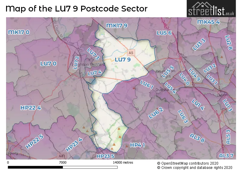
The LU7 9 Postcode shares a border with MK17 9 (Woburn, Stoke Hammond, Great Brickhill), HP23 4 (TRING, Long Marston, Marsworth), HP23 5 (TRING, Aldbury, Cow Roast), LU5 6 (Toddington, Houghton Regis, Harlington), LU6 1 (DUNSTABLE, Totternhoe), LU6 2 (Eaton Bray, Edlesborough, DUNSTABLE), LU7 0 (Wing, Stewkley, Cheddington), HP4 1 (BERKHAMSTED, Little Gaddesden, Dagnall), LU7 3 (LEIGHTON BUZZARD) and LU7 4 (LEIGHTON BUZZARD).
The sector is within the post town of LEIGHTON BUZZARD.
LU7 9 is a postcode sector within the LU7 postcode district which is within the MK Milton Keynes postcode area.
The Royal Mail delivery office for the LU7 9 postal sector is the Leighton Buzzard Delivery Office.
The area of the LU7 9 postcode sector is 24.46 square miles which is 63.36 square kilometres or 15,655.70 square acres.
The LU7 9 postcode sector is crossed by the A5 Major A road.
Waterways within the LU7 9 postcode sector include the Grand Union Canal, River Ouzel, Clipstone Brook.

Map of the LU7 9 Postcode Sector
Explore the LU7 9 postcode sector by using our free interactive map.
| L | U | 7 | - | 9 | X | X |
| L | U | 7 | Space | 9 | Letter | Letter |
Official List of Streets
Pitstone (59 Streets)
Hockliffe (16 Streets)
LEIGHTON BUZZARD (20 Streets)
Ivinghoe Aston (5 Streets)
Stanbridge (14 Streets)
Tilsworth (6 Streets)
Slapton (6 Streets)
Tebworth (9 Streets)
Great Billington (9 Streets)
Ivinghoe (16 Streets)
Eggington (4 Streets)
Heath and Reach (4 Streets)
Little Billington (2 Streets)
Cheddington (1 Streets)
Wingfield (3 Streets)
Unofficial Streets or Alternative Spellings
Toddington
DUNSTABLE ROAD LEIGHTON ROADBletchley
WATLING STREETRingshall
BEACON ROADTRING
NORTHFIELD ROAD ALEXANDER WAY BABBAGE GROVE BAIRD CLOSE BERKLEY CLOSE BITTERN MEAD BROWNLOW BRIDGE BUCKLAND CORNER CAMPBELLLANE CHADWICK CRESCENT CRICK CLOSE CURLEW CROFT DIRAC MEAD DUNCOMBE TERRACE FRASERFIELDS WAY GALTON CORNER GIPSY LANE GOOSE GREEN GREENACRES GULLICOT WAY HILL VIEW LANE HOCKLEY COURT HOPPER LANE JENNER CLOSE KELSEY MEADOW KINGS WAY LISTER CORNER MILE TREE ROAD MORSE END OLD DAIRY COURT OVEREND GREEN LANE PARK VIEW LANE PUBLIC RIGHT OF WAY 14 PUBLIC RIGHT OF WAY 15 RAMSAY DRIVE ROWLAND RUTHERFORD CRESCENT SAGAN RISE SANDALL ROAD SEWELL GREENWAY THE BLACKBIRDS THE GREEN TORNAY COURT TOWNES VIEW WALLIS DRIVE WOODCOCK LANE YEWTREE CLOSEAston Clinton
LOWER ICKNIELD WAYEaton Bray
THE RYEEdlesborough
LEIGHTON ROADHorton
HORTON ROADCheddington
STATION ROADLEIGHTON BUZZARD
BRIGGINGTON WAY CONDOR DRIVE DUNNOCK DRIVE SISKIN GROVE WRYNECKHeath and Reach
GIG LANE WOBURN ROADAldbury
STOCKS ROADNorthall
SLAPTON LANEBulbourne
UPPER ICKNIELD WAYSchools and Places of Education Within the LU7 9 Postcode Sector
Brookmead School
Foundation school
High Street, Leighton Buzzard, Bedfordshire, LU7 9EX
Head: Mrs Esther Taylor
Ofsted Rating: Good
Inspection: 2019-12-04 (1632 days ago)
Website: Visit Brookmead School Website
Phone: 01296668543
Number of Pupils: 317
Stanbridge Lower School
Community school
Tilsworth Road, Leighton Buzzard, Bedfordshire, LU7 9HY
Head: Ms Samantha Gooding
Ofsted Rating: Good
Inspection: 2022-09-29 (602 days ago)
Website: Visit Stanbridge Lower School Website
Phone: 01525210328
Number of Pupils: 113
House Prices in the LU7 9 Postcode Sector
| Type of Property | 2018 Average | 2018 Sales | 2017 Average | 2017 Sales | 2016 Average | 2016 Sales | 2015 Average | 2015 Sales |
|---|---|---|---|---|---|---|---|---|
| Detached | £509,567 | 79 | £484,984 | 78 | £461,792 | 76 | £390,583 | 88 |
| Semi-Detached | £346,577 | 50 | £348,167 | 53 | £359,213 | 56 | £318,330 | 70 |
| Terraced | £323,714 | 48 | £306,629 | 46 | £271,512 | 38 | £265,214 | 82 |
| Flats | £200,830 | 34 | £193,804 | 39 | £204,895 | 28 | £167,388 | 43 |
Important Postcodes LU7 9 in the Postcode Sector
LU7 9BE is the postcode for Pitstone Surgery, Yardley Avenue
LU7 9EX is the postcode for MAIN BUILDING, Brookmead School, High Street, and Brookmead School, High Street
LU7 9HY is the postcode for Stanbridge Lower School, Tilsworth Road, and Stanbridge Lower School, Tilsworth Road, Stanbridge
LU7 9LL is the postcode for Hockliffe Lower School, Woburn Road, Hockliffe
| The LU7 9 Sector is within these Local Authorities |
|
|---|---|
| The LU7 9 Sector is within these Counties |
|
| The LU7 9 Sector is within these Water Company Areas |
|
Tourist Attractions within the LU7 9 Postcode Area
We found 2 visitor attractions within the LU7 postcode area
| Pitstone Green Museum |
|---|
| Museums & Art Galleries |
| Museum and / or Art Gallery |
| View Pitstone Green Museum on Google Maps |
| Pitstone Windmill |
| Historic Properties |
| Other Historic Property |
| View Pitstone Windmill on Google Maps |