The N1 7 postcode sector is within the county of Greater London.
Did you know? According to the 2021 Census, the N1 7 postcode sector is home to a bustling 12,761 residents!
Given that each sector allows for 400 unique postcode combinations. Letters C, I, K, M, O and V are not allowed in the last two letters of a postcode. With 243 postcodes already in use, this leaves 157 units available.
The largest settlements in the N1 7 postal code are HACKNEY and ISLINGTON .
The N1 7 Postcode shares a border with N1 5 (HACKNEY ), N1 3 (ISLINGTON , HACKNEY ), N1 8 (ISLINGTON ), EC1V 1 (ISLINGTON , HACKNEY ) and N1 6 (HACKNEY ).
The sector is within the post town of LONDON.
N1 7 is a postcode sector within the N1 postcode district which is within the N North London postcode area.
The Royal Mail delivery office for the N1 7 postal sector is the Islington Delivery Office.
The area of the N1 7 postcode sector is 0.22 square miles which is 0.57 square kilometres or 140.44 square acres.
Waterways within the N1 7 postcode sector include the Regent's Canal.

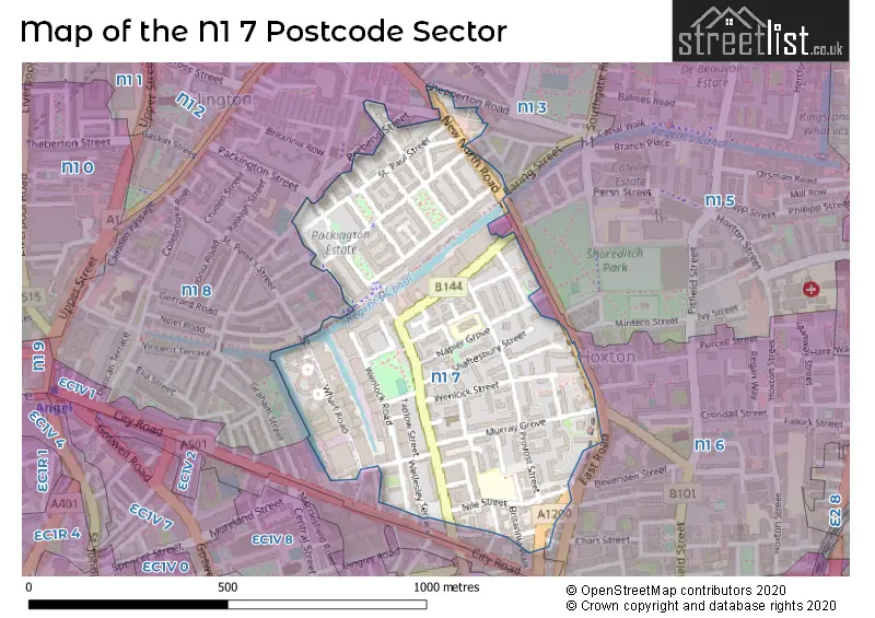
Map of the N1 7 Postcode Sector
Explore the N1 7 postcode sector by using our free interactive map.
| N | 1 | - | 7 | X | X |
| N | 1 | Space | 7 | Letter | Letter |
Official List of Streets
Islington (28 Streets)
Hackney (38 Streets)
Unofficial Streets or Alternative Spellings
Hackney
SILBURY STREETIslington
BARING STREET BASIRE STREET FROME STREET PREBEND STREET RHEIDOL TERRACE RIDGEWELL CLOSE SHEPPERTON ROAD WILTON VILLAS ALFORD PLACE BRIDGESIDE LODGE CANONBURY YARD GRAND JUNCTION WHARF OAKLEIGH COURT PACKINGTON STREET BRIDGE PICKFORDS WHARF REGENTS CANAL TOWPATH SAINT PETERS STREET ST PETERS STREETWeather Forecast for N1 7
Press Button to Show Forecast for Islington
| Time Period | Icon | Description | Temperature | Rain Probability | Wind |
|---|---|---|---|---|---|
| 15:00 to 18:00 | Cloudy | 12.0°C (feels like 11.0°C) | 5.00% | ESE 4 mph | |
| 18:00 to 21:00 | Cloudy | 11.0°C (feels like 9.0°C) | 6.00% | E 9 mph | |
| 21:00 to 00:00 | Cloudy | 9.0°C (feels like 7.0°C) | 7.00% | E 9 mph |
Press Button to Show Forecast for Islington
| Time Period | Icon | Description | Temperature | Rain Probability | Wind |
|---|---|---|---|---|---|
| 00:00 to 03:00 | Light rain | 8.0°C (feels like 6.0°C) | 47.00% | ENE 9 mph | |
| 03:00 to 06:00 | Heavy rain | 7.0°C (feels like 4.0°C) | 86.00% | NE 9 mph | |
| 06:00 to 09:00 | Light rain | 6.0°C (feels like 4.0°C) | 62.00% | NE 9 mph | |
| 09:00 to 12:00 | Overcast | 8.0°C (feels like 5.0°C) | 16.00% | NE 9 mph | |
| 12:00 to 15:00 | Overcast | 11.0°C (feels like 9.0°C) | 13.00% | NE 7 mph | |
| 15:00 to 18:00 | Cloudy | 12.0°C (feels like 11.0°C) | 18.00% | ENE 7 mph | |
| 18:00 to 21:00 | Light rain | 12.0°C (feels like 10.0°C) | 81.00% | NE 9 mph | |
| 21:00 to 00:00 | Heavy rain | 10.0°C (feels like 8.0°C) | 91.00% | NE 9 mph |
Press Button to Show Forecast for Islington
| Time Period | Icon | Description | Temperature | Rain Probability | Wind |
|---|---|---|---|---|---|
| 00:00 to 03:00 | Heavy rain | 9.0°C (feels like 7.0°C) | 91.00% | NNE 9 mph | |
| 03:00 to 06:00 | Heavy rain | 9.0°C (feels like 7.0°C) | 92.00% | NE 9 mph | |
| 06:00 to 09:00 | Light rain | 9.0°C (feels like 7.0°C) | 57.00% | NNW 7 mph | |
| 09:00 to 12:00 | Heavy rain | 9.0°C (feels like 7.0°C) | 83.00% | W 9 mph | |
| 12:00 to 15:00 | Light rain | 9.0°C (feels like 7.0°C) | 57.00% | WNW 11 mph | |
| 15:00 to 18:00 | Cloudy | 10.0°C (feels like 8.0°C) | 14.00% | W 11 mph | |
| 18:00 to 21:00 | Cloudy | 11.0°C (feels like 9.0°C) | 8.00% | WSW 9 mph | |
| 21:00 to 00:00 | Partly cloudy (night) | 9.0°C (feels like 8.0°C) | 4.00% | SW 7 mph |
Press Button to Show Forecast for Islington
| Time Period | Icon | Description | Temperature | Rain Probability | Wind |
|---|---|---|---|---|---|
| 00:00 to 03:00 | Clear night | 8.0°C (feels like 7.0°C) | 2.00% | SW 4 mph | |
| 03:00 to 06:00 | Clear night | 7.0°C (feels like 5.0°C) | 1.00% | SSW 4 mph | |
| 06:00 to 09:00 | Sunny day | 7.0°C (feels like 6.0°C) | 1.00% | S 4 mph | |
| 09:00 to 12:00 | Partly cloudy (day) | 12.0°C (feels like 10.0°C) | 1.00% | S 9 mph | |
| 12:00 to 15:00 | Cloudy | 14.0°C (feels like 12.0°C) | 6.00% | S 11 mph | |
| 15:00 to 18:00 | Partly cloudy (day) | 15.0°C (feels like 13.0°C) | 3.00% | S 11 mph | |
| 18:00 to 21:00 | Sunny day | 14.0°C (feels like 12.0°C) | 3.00% | S 9 mph | |
| 21:00 to 00:00 | Clear night | 11.0°C (feels like 10.0°C) | 1.00% | SSE 7 mph |
Press Button to Show Forecast for Islington
| Time Period | Icon | Description | Temperature | Rain Probability | Wind |
|---|---|---|---|---|---|
| 00:00 to 03:00 | Clear night | 10.0°C (feels like 8.0°C) | 1.00% | SE 7 mph | |
| 03:00 to 06:00 | Clear night | 9.0°C (feels like 8.0°C) | 2.00% | ESE 7 mph | |
| 06:00 to 09:00 | Cloudy | 9.0°C (feels like 8.0°C) | 7.00% | ESE 7 mph | |
| 09:00 to 12:00 | Cloudy | 13.0°C (feels like 11.0°C) | 5.00% | ESE 7 mph | |
| 12:00 to 15:00 | Cloudy | 16.0°C (feels like 14.0°C) | 9.00% | SE 9 mph | |
| 15:00 to 18:00 | Cloudy | 17.0°C (feels like 15.0°C) | 11.00% | SE 9 mph | |
| 18:00 to 21:00 | Cloudy | 16.0°C (feels like 14.0°C) | 10.00% | SE 9 mph | |
| 21:00 to 00:00 | Light rain shower (night) | 13.0°C (feels like 12.0°C) | 34.00% | ESE 7 mph |
Schools and Places of Education Within the N1 7 Postcode Sector
New Regent's College
Pupil referral unit
Nile Street, London, , N1 7RD
Head: Mr Richard Brown
Ofsted Rating: Good
Inspection: 2021-06-24 (1037 days ago)
Website: Visit New Regent's College Website
Phone: 02089856833
Number of Pupils: 41
Thomas Fairchild Community School
Community school
Forston Street, London, , N1 7HA
Head: Mr Matthew Trahair
Ofsted Rating: Good
Inspection: 2023-09-27 (212 days ago)
Website: Visit Thomas Fairchild Community School Website
Phone: 02072539469
Number of Pupils: 206
House Prices in the N1 7 Postcode Sector
| Type of Property | 2018 Average | 2018 Sales | 2017 Average | 2017 Sales | 2016 Average | 2016 Sales | 2015 Average | 2015 Sales |
|---|---|---|---|---|---|---|---|---|
| Detached | £900,000 | 1 | £0 | 0 | £0 | 0 | £0 | 0 |
| Semi-Detached | £1,090,000 | 1 | £0 | 0 | £0 | 0 | £0 | 0 |
| Terraced | £1,140,560 | 17 | £1,113,269 | 13 | £1,342,205 | 15 | £1,426,159 | 24 |
| Flats | £648,253 | 124 | £633,171 | 132 | £705,070 | 373 | £612,947 | 168 |
Important Postcodes N1 7 in the Postcode Sector
N1 7ED is the postcode for Museum of London Archaeology Service, 46 Eagle Wharf Road
N1 7HX is the postcode for Thomas Fairchild Community School, Napier Grove
N1 7LF is the postcode for Shoreditch Police Station, 4-6 Sheperdess Walk, Shoreditch Police Station, 4-6 Shepherdess Walk, Hackney, SHOREDITCH POLICE STATION, Metropolitan Police, Shoreditch Police Station, 4-6 Shepherdess Walk, and Metropolitan Police, Shoreditch Police Station, 4-6 Shepherdess Walk
N1 7PT is the postcode for 1, Cropley Street
N1 7RD is the postcode for Regent Vocational College, Nile Street
N1 7SW is the postcode for Synergy, Unit D-e, 20-22 Wharf Road
| The N1 7 Sector is within these Local Authorities |
|
|---|---|
| The N1 7 Sector is within these Counties |
|
| The N1 7 Sector is within these Water Company Areas |
|