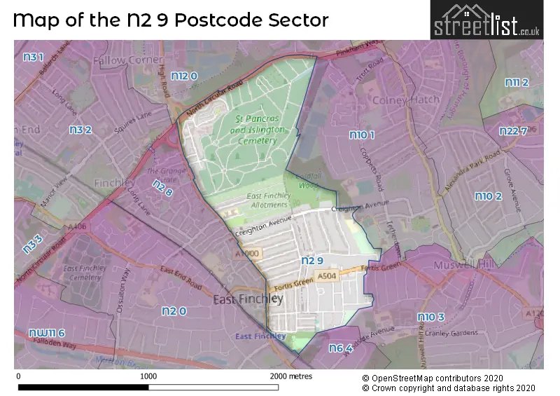
The N2 9 postcode sector is within the county of Greater London.
Did you know? According to the 2021 Census, the N2 9 postcode sector is home to a bustling 8,068 residents!
Given that each sector allows for 400 unique postcode combinations. Letters C, I, K, M, O and V are not allowed in the last two letters of a postcode. With 154 postcodes already in use, this leaves 246 units available.
The largest settlements in the N2 9 postal code are EAST FINCHLEY and HORNSEY .
The N2 9 Postcode shares a border with N2 0 (EAST FINCHLEY , HORNSEY , HAMPSTEAD GARDEN SUBURB ), N6 4 (HORNSEY ), N10 1 (HORNSEY , MUSWELL HILL , COLNEY HATCH ), N10 3 (HORNSEY ), N12 0 (NORTH FINCHLEY , COLNEY HATCH , FINCHLEY ) and N2 8 (EAST FINCHLEY , FINCHLEY ).
The sector is within the post town of LONDON.
N2 9 is a postcode sector within the N2 postcode district which is within the N North London postcode area.
The Royal Mail delivery office for the N2 9 postal sector is the East Finchley Sdelivery Office.
The area of the N2 9 postcode sector is 0.68 square miles which is 1.77 square kilometres or 437.94 square acres.

Map of the N2 9 Postcode Sector
Explore the N2 9 postcode sector by using our free interactive map.
| N | 2 | - | 9 | X | X |
| N | 2 | Space | 9 | Letter | Letter |
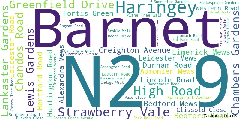
Official List of Streets
Haringey (21 Streets)
Barnet (31 Streets)
Unofficial Streets or Alternative Spellings
Haringey
MIDHURST AVENUEBarnet
BOBBY MOORE WAY BROOK WALK DIPLOMA AVENUE EAST END ROAD INDIGO WALK KITCHENER ROAD LESLIE ROAD NORTH CIRCULAR ROAD PINKHAM WAY BISHOPS PATH BOUNDARY ROAD BROMPTON GROVE BROOK ROAD CARTERS ROAD CENTRAL ROAD CENTRE AVENUE CENTRE ROAD CHAPEL HILL CHURCH AVENUE CHURCH ROAD NORTH CHURCH ROAD SOUTH CIRCULAR ROAD CROSS ROAD EAST ROAD FRANCIS ROAD GARDEN ROAD HARWELL PASSAGE HARWOODS PATH HIGH VIEW ROAD JOINT ROAD JORDANS HILL JUNCTION PATH KEW ROAD LOWER ROAD LYGOE ROAD MAUSOLEUM ROAD MIDDLE ROAD NEW ROAD NORTH ROAD ORCHARD COURT PARKERS ROAD QUADRANT ROAD RALEIGH ROAD RESERVE ROAD ROMAN ROAD SAINT PANCRAS COURT SARGENTS HILL SHAW PLACE SOUTHGATE WAY ST DAVIDS AVENUE ST GEORGES AVENUE ST LUKES PATH ST MARTINS ROAD ST MARYS ROAD ST PATRICKS AVENUE ST PAULS AVENUE ST PETERS AVENUE ST PHILIPS AVENUE STRAIGHT PATH UPPER ROAD VIADUCT ROAD WEBSTERS PATH WESLEY ROAD WEST ROAD WITHINGTON ROAD WOODSIDE COTTAGESWeather Forecast for N2 9
Press Button to Show Forecast for Hampstead Heath Youth Hostel
| Time Period | Icon | Description | Temperature | Rain Probability | Wind |
|---|---|---|---|---|---|
| 21:00 to 00:00 | Cloudy | 8.0°C (feels like 6.0°C) | 7.00% | E 9 mph |
Press Button to Show Forecast for Hampstead Heath Youth Hostel
| Time Period | Icon | Description | Temperature | Rain Probability | Wind |
|---|---|---|---|---|---|
| 00:00 to 03:00 | Cloudy | 7.0°C (feels like 4.0°C) | 52.00% | ENE 9 mph | |
| 03:00 to 06:00 | Light rain | 6.0°C (feels like 3.0°C) | 56.00% | ENE 9 mph | |
| 06:00 to 09:00 | Light rain | 6.0°C (feels like 3.0°C) | 61.00% | NE 9 mph | |
| 09:00 to 12:00 | Overcast | 7.0°C (feels like 4.0°C) | 45.00% | NE 11 mph | |
| 12:00 to 15:00 | Overcast | 10.0°C (feels like 8.0°C) | 12.00% | ENE 9 mph | |
| 15:00 to 18:00 | Cloudy | 12.0°C (feels like 10.0°C) | 9.00% | NE 9 mph | |
| 18:00 to 21:00 | Light rain | 10.0°C (feels like 8.0°C) | 59.00% | NE 11 mph | |
| 21:00 to 00:00 | Heavy rain | 9.0°C (feels like 6.0°C) | 89.00% | NE 11 mph |
Press Button to Show Forecast for Hampstead Heath Youth Hostel
| Time Period | Icon | Description | Temperature | Rain Probability | Wind |
|---|---|---|---|---|---|
| 00:00 to 03:00 | Heavy rain | 8.0°C (feels like 5.0°C) | 92.00% | NNE 11 mph | |
| 03:00 to 06:00 | Heavy rain | 8.0°C (feels like 6.0°C) | 92.00% | NE 9 mph | |
| 06:00 to 09:00 | Heavy rain | 8.0°C (feels like 6.0°C) | 85.00% | NNW 9 mph | |
| 09:00 to 12:00 | Heavy rain | 8.0°C (feels like 6.0°C) | 84.00% | WNW 9 mph | |
| 12:00 to 15:00 | Light rain | 9.0°C (feels like 6.0°C) | 56.00% | W 13 mph | |
| 15:00 to 18:00 | Overcast | 10.0°C (feels like 7.0°C) | 16.00% | W 11 mph | |
| 18:00 to 21:00 | Cloudy | 10.0°C (feels like 8.0°C) | 8.00% | W 9 mph | |
| 21:00 to 00:00 | Partly cloudy (night) | 9.0°C (feels like 7.0°C) | 4.00% | SW 7 mph |
Press Button to Show Forecast for Hampstead Heath Youth Hostel
| Time Period | Icon | Description | Temperature | Rain Probability | Wind |
|---|---|---|---|---|---|
| 00:00 to 03:00 | Clear night | 7.0°C (feels like 6.0°C) | 2.00% | SW 4 mph | |
| 03:00 to 06:00 | Clear night | 6.0°C (feels like 4.0°C) | 1.00% | SSW 4 mph | |
| 06:00 to 09:00 | Sunny day | 6.0°C (feels like 5.0°C) | 1.00% | S 4 mph | |
| 09:00 to 12:00 | Partly cloudy (day) | 11.0°C (feels like 9.0°C) | 2.00% | S 9 mph | |
| 12:00 to 15:00 | Cloudy | 14.0°C (feels like 12.0°C) | 4.00% | S 11 mph | |
| 15:00 to 18:00 | Partly cloudy (day) | 15.0°C (feels like 12.0°C) | 2.00% | S 11 mph | |
| 18:00 to 21:00 | Sunny day | 13.0°C (feels like 12.0°C) | 3.00% | S 9 mph | |
| 21:00 to 00:00 | Clear night | 11.0°C (feels like 9.0°C) | 1.00% | SSE 7 mph |
Press Button to Show Forecast for Hampstead Heath Youth Hostel
| Time Period | Icon | Description | Temperature | Rain Probability | Wind |
|---|---|---|---|---|---|
| 00:00 to 03:00 | Clear night | 9.0°C (feels like 8.0°C) | 1.00% | SE 7 mph | |
| 03:00 to 06:00 | Clear night | 8.0°C (feels like 7.0°C) | 2.00% | ESE 7 mph | |
| 06:00 to 09:00 | Partly cloudy (day) | 9.0°C (feels like 7.0°C) | 4.00% | ESE 7 mph | |
| 09:00 to 12:00 | Cloudy | 12.0°C (feels like 11.0°C) | 6.00% | ESE 7 mph | |
| 12:00 to 15:00 | Cloudy | 15.0°C (feels like 14.0°C) | 8.00% | SE 9 mph | |
| 15:00 to 18:00 | Cloudy | 16.0°C (feels like 14.0°C) | 10.00% | SE 9 mph | |
| 18:00 to 21:00 | Cloudy | 15.0°C (feels like 14.0°C) | 11.00% | SE 9 mph | |
| 21:00 to 00:00 | Cloudy | 13.0°C (feels like 11.0°C) | 10.00% | ESE 7 mph |
Schools and Places of Education Within the N2 9 Postcode Sector
Martin Primary School
Community school
Plane Tree Walk, London, , N2 9JP
Head: Mrs Ziz Chater
Ofsted Rating: Good
Inspection: 2023-10-18 (191 days ago)
Website: Visit Martin Primary School Website
Phone: 02088831455
Number of Pupils: 673
House Prices in the N2 9 Postcode Sector
| Type of Property | 2018 Average | 2018 Sales | 2017 Average | 2017 Sales | 2016 Average | 2016 Sales | 2015 Average | 2015 Sales |
|---|---|---|---|---|---|---|---|---|
| Detached | £1,410,000 | 3 | £1,945,833 | 6 | £1,992,168 | 8 | £1,292,500 | 6 |
| Semi-Detached | £1,311,110 | 20 | £1,354,321 | 14 | £1,108,018 | 14 | £1,532,148 | 21 |
| Terraced | £1,099,411 | 28 | £1,139,865 | 26 | £1,003,010 | 28 | £991,804 | 29 |
| Flats | £534,034 | 29 | £430,058 | 26 | £407,063 | 39 | £386,822 | 45 |
Important Postcodes N2 9 in the Postcode Sector
N2 9BB is the postcode for London Borough of Barnet Council, East Finchley Public Library, 226 High Road
N2 9EX is the postcode for University College London, Bernard Johnson House, 78 Fortis Green
N2 9HW is the postcode for Metropolitan Police, Muswell Hill Police Station, 115 Fortis Green
N2 9JP is the postcode for Martin Infant & Junior School, Plane Tree Walk
| The N2 9 Sector is within these Local Authorities |
|
|---|---|
| The N2 9 Sector is within these Counties |
|
| The N2 9 Sector is within these Water Company Areas |
|