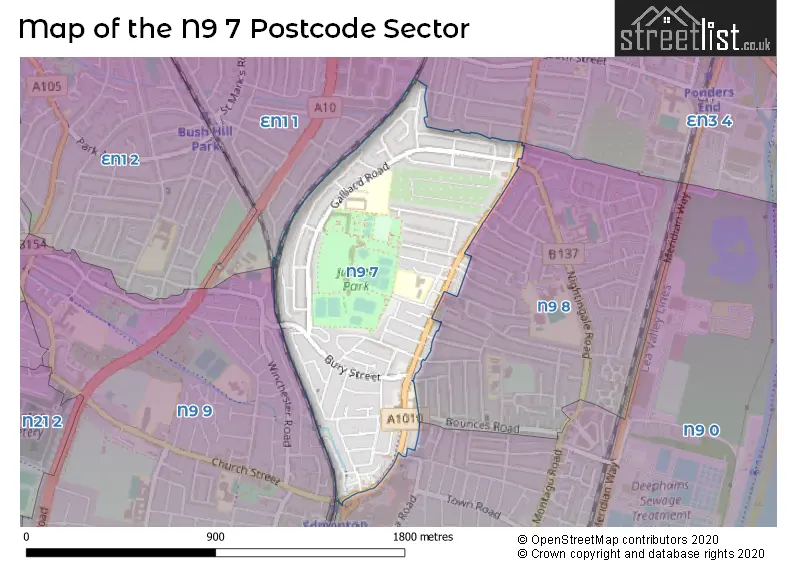
The N9 7 postcode sector is within the county of Greater London.
Did you know? According to the 2021 Census, the N9 7 postcode sector is home to a bustling 10,706 residents!
Given that each sector allows for 400 unique postcode combinations. Letters C, I, K, M, O and V are not allowed in the last two letters of a postcode. With 172 postcodes already in use, this leaves 228 units available.
The N9 7 postal code covers the settlement of EDMONTON .
The N9 7 Postcode shares a border with N9 0 (EDMONTON ), N9 8 (EDMONTON ), N9 9 (EDMONTON ), EN1 1 (ENFIELD ) and EN3 4 (ENFIELD ).
The sector is within the post town of LONDON.
N9 7 is a postcode sector within the N9 postcode district which is within the N North London postcode area.
The Royal Mail delivery office for the N9 7 postal sector is the Lower Edmonton Sdelivery Office.
The area of the N9 7 postcode sector is 0.47 square miles which is 1.22 square kilometres or 301.11 square acres.

Map of the N9 7 Postcode Sector
Explore the N9 7 postcode sector by using our free interactive map.
| N | 9 | - | 7 | X | X |
| N | 9 | Space | 7 | Letter | Letter |
Official List of Streets
Enfield (59 Streets)
Unofficial Streets or Alternative Spellings
Enfield
BOUNCES LANE BOUNCES ROAD CAUSEYWARE ROAD CHURCH STREET ELIZABETH RIDE FOREST ROAD GROSVENOR ROAD LOWDEN ROAD MONMOUTH ROAD NIGHTINGALE ROAD ROSEMARY AVENUE TRAMWAY AVENUE TUDOR ROADENFIELD
HIGH STREET NORTHFIELD ROADWeather Forecast for N9 7
Press Button to Show Forecast for Enfield
| Time Period | Icon | Description | Temperature | Rain Probability | Wind |
|---|---|---|---|---|---|
| 12:00 to 15:00 | Cloudy | 11.0°C (feels like 10.0°C) | 5.00% | ENE 4 mph | |
| 15:00 to 18:00 | Overcast | 12.0°C (feels like 11.0°C) | 8.00% | ENE 4 mph | |
| 18:00 to 21:00 | Cloudy | 11.0°C (feels like 9.0°C) | 8.00% | E 9 mph | |
| 21:00 to 00:00 | Cloudy | 8.0°C (feels like 6.0°C) | 8.00% | E 9 mph |
Press Button to Show Forecast for Enfield
| Time Period | Icon | Description | Temperature | Rain Probability | Wind |
|---|---|---|---|---|---|
| 00:00 to 03:00 | Overcast | 7.0°C (feels like 5.0°C) | 17.00% | ENE 9 mph | |
| 03:00 to 06:00 | Light rain | 7.0°C (feels like 4.0°C) | 60.00% | NE 7 mph | |
| 06:00 to 09:00 | Heavy rain | 6.0°C (feels like 4.0°C) | 82.00% | NE 9 mph | |
| 09:00 to 12:00 | Overcast | 7.0°C (feels like 5.0°C) | 44.00% | NE 9 mph | |
| 12:00 to 15:00 | Cloudy | 10.0°C (feels like 8.0°C) | 15.00% | NE 9 mph | |
| 15:00 to 18:00 | Cloudy | 12.0°C (feels like 10.0°C) | 11.00% | NE 7 mph | |
| 18:00 to 21:00 | Heavy rain | 11.0°C (feels like 9.0°C) | 79.00% | NE 9 mph | |
| 21:00 to 00:00 | Light rain | 9.0°C (feels like 7.0°C) | 67.00% | NE 9 mph |
Press Button to Show Forecast for Enfield
| Time Period | Icon | Description | Temperature | Rain Probability | Wind |
|---|---|---|---|---|---|
| 00:00 to 03:00 | Heavy rain | 9.0°C (feels like 6.0°C) | 89.00% | NNE 11 mph | |
| 03:00 to 06:00 | Heavy rain | 8.0°C (feels like 6.0°C) | 89.00% | NNE 9 mph | |
| 06:00 to 09:00 | Heavy rain | 8.0°C (feels like 6.0°C) | 88.00% | N 9 mph | |
| 09:00 to 12:00 | Light rain | 9.0°C (feels like 7.0°C) | 58.00% | WNW 9 mph | |
| 12:00 to 15:00 | Light rain | 10.0°C (feels like 7.0°C) | 55.00% | W 11 mph | |
| 15:00 to 18:00 | Overcast | 10.0°C (feels like 8.0°C) | 20.00% | W 9 mph | |
| 18:00 to 21:00 | Cloudy | 11.0°C (feels like 9.0°C) | 10.00% | W 7 mph | |
| 21:00 to 00:00 | Cloudy | 9.0°C (feels like 8.0°C) | 8.00% | SW 7 mph |
Press Button to Show Forecast for Enfield
| Time Period | Icon | Description | Temperature | Rain Probability | Wind |
|---|---|---|---|---|---|
| 00:00 to 03:00 | Clear night | 8.0°C (feels like 6.0°C) | 3.00% | SW 4 mph | |
| 03:00 to 06:00 | Clear night | 6.0°C (feels like 5.0°C) | 1.00% | SSW 4 mph | |
| 06:00 to 09:00 | Sunny day | 7.0°C (feels like 5.0°C) | 1.00% | S 4 mph | |
| 09:00 to 12:00 | Sunny day | 11.0°C (feels like 10.0°C) | 1.00% | S 9 mph | |
| 12:00 to 15:00 | Cloudy | 14.0°C (feels like 12.0°C) | 8.00% | S 11 mph | |
| 15:00 to 18:00 | Partly cloudy (day) | 15.0°C (feels like 13.0°C) | 2.00% | S 11 mph | |
| 18:00 to 21:00 | Sunny day | 14.0°C (feels like 12.0°C) | 4.00% | S 9 mph | |
| 21:00 to 00:00 | Clear night | 11.0°C (feels like 10.0°C) | 1.00% | SSE 7 mph |
Press Button to Show Forecast for Enfield
| Time Period | Icon | Description | Temperature | Rain Probability | Wind |
|---|---|---|---|---|---|
| 00:00 to 03:00 | Clear night | 10.0°C (feels like 8.0°C) | 1.00% | SE 7 mph | |
| 03:00 to 06:00 | Clear night | 9.0°C (feels like 7.0°C) | 2.00% | ESE 7 mph | |
| 06:00 to 09:00 | Cloudy | 9.0°C (feels like 8.0°C) | 8.00% | ESE 7 mph | |
| 09:00 to 12:00 | Cloudy | 13.0°C (feels like 11.0°C) | 8.00% | ESE 7 mph | |
| 12:00 to 15:00 | Cloudy | 16.0°C (feels like 14.0°C) | 10.00% | SE 9 mph | |
| 15:00 to 18:00 | Cloudy | 17.0°C (feels like 15.0°C) | 12.00% | SE 9 mph | |
| 18:00 to 21:00 | Cloudy | 16.0°C (feels like 14.0°C) | 12.00% | SE 9 mph | |
| 21:00 to 00:00 | Cloudy | 13.0°C (feels like 12.0°C) | 16.00% | ESE 7 mph |
Schools and Places of Education Within the N9 7 Postcode Sector
Galliard Primary School
Academy converter
Galliard Road, London, , N9 7PE
Head: Mrs Caroline Clifford
Ofsted Rating: Outstanding
Inspection: 2023-07-12 (289 days ago)
Website: Visit Galliard Primary School Website
Phone: 02088041818
Number of Pupils: 717
Houndsfield Primary School
Academy sponsor led
Ripon Road, London, , N9 7RE
Head: Mr Robert Jenkin
Ofsted Rating: Good
Inspection: 2023-06-08 (323 days ago)
Website: Visit Houndsfield Primary School Website
Phone: 02088053406
Number of Pupils: 487
St Edmund's Catholic Primary School
Voluntary aided school
Hertford Road, Edmonton, , N9 7HJ
Head: Mr Daniel Abrahams
Ofsted Rating: Good
Inspection: 2023-03-22 (401 days ago)
Website: Visit St Edmund's Catholic Primary School Website
Phone: 02088072664
Number of Pupils: 390
House Prices in the N9 7 Postcode Sector
| Type of Property | 2018 Average | 2018 Sales | 2017 Average | 2017 Sales | 2016 Average | 2016 Sales | 2015 Average | 2015 Sales |
|---|---|---|---|---|---|---|---|---|
| Detached | £450,000 | 1 | £500,000 | 1 | £345,000 | 1 | £320,500 | 1 |
| Semi-Detached | £405,227 | 11 | £403,500 | 10 | £377,938 | 8 | £359,250 | 12 |
| Terraced | £371,970 | 66 | £355,931 | 65 | £351,951 | 77 | £289,092 | 75 |
| Flats | £265,923 | 26 | £208,613 | 23 | £207,324 | 25 | £184,235 | 34 |
Important Postcodes N9 7 in the Postcode Sector
N9 7HD is the postcode for Forest Primary Care Centre, 308a Hertford Road
N9 7HJ is the postcode for ST EDMUNDS RC PRIMARY SCHOOL, HERTFORD ROAD, EDMONTON, St. Edmunds RC School, Hertford Road, and ST EDMUNDS RC PRIMARY SCHOOL, HERTFORD ROAD
N9 7JR is the postcode for Newbury Secondary Tuition Centre, Bury Street, Edmonton
N9 7PE is the postcode for CHILDRENS CENTRE, GALLIARD PRIMARY SCHOOL, GALLIARD ROAD, and Galliard Primary School, Galliard Road
N9 7RA is the postcode for William Preye Centre, 6 Houndsfield Road
N9 7RE is the postcode for Main School, Houndsfield Primary School, Ripon Road, Early Years Block, HOUNDSFIELD PRIMARY SCHOOL, RIPON ROAD, Houndsfield Primary School, Ripon Road, and HOUNDSFIELD SUITE, Houndsfield Primary School, Ripon Road
N9 7SA is the postcode for Edmonton Family Centre, 5 Lacey Close
| The N9 7 Sector is within these Local Authorities |
|
|---|---|
| The N9 7 Sector is within these Counties |
|
| The N9 7 Sector is within these Water Company Areas |
|