The NE15 7 postcode sector is within the county of Tyne & Wear.
Did you know? According to the 2021 Census, the NE15 7 postcode sector is home to a bustling 9,205 residents!
Given that each sector allows for 400 unique postcode combinations. Letters C, I, K, M, O and V are not allowed in the last two letters of a postcode. With 197 postcodes already in use, this leaves 203 units available.
The largest settlement in the NE15 7 postal code is NEWCASTLE UPON TYNE followed by Lemington, and West Denton.
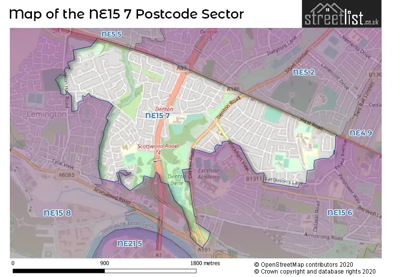
The NE15 7 Postcode shares a border with NE5 2 (NEWCASTLE UPON TYNE, East Denton), NE5 5 (NEWCASTLE UPON TYNE, Westerhope, West Denton), NE15 6 (NEWCASTLE UPON TYNE, Benwell Grange) and NE15 8 (NEWCASTLE UPON TYNE, Lemington, Newburn).
The sector is within the post town of NEWCASTLE UPON TYNE.
NE15 7 is a postcode sector within the NE15 postcode district which is within the NE Newcastle upon Tyne postcode area.
The Royal Mail delivery office for the NE15 7 postal sector is the West Delivery Office (ne).
The area of the NE15 7 postcode sector is 0.86 square miles which is 2.22 square kilometres or 549.27 square acres.
The NE15 7 postcode sector is crossed by the A1 Major A road.
The NE15 7 postcode sector is crossed by the A69 Major A road.

Map of the NE15 7 Postcode Sector
Explore the NE15 7 postcode sector by using our free interactive map.
| N | E | 1 | 5 | - | 7 | X | X |
| N | E | 1 | 5 | Space | 7 | Letter | Letter |
Official List of Streets
NEWCASTLE UPON TYNE (124 Streets)
South Denton (2 Streets)
West Denton (2 Streets)
Lemington (2 Streets)
Unofficial Streets or Alternative Spellings
NEWCASTLE UPON TYNE
BALFOUR ROAD BENWELL VILLAGE DORSET ROAD ELDON ROAD FOWBERRY ROAD HEIGHLEY STREET ORCHARD-LEIGH OUSTON STREET SCOTSWOOD ROAD SILVER LONNEN SILVERHILL DRIVE WESTACRE GARDENS YEWCROFT AVENUEScotswood
WHITFIELD ROADLemington
DENE AVENUE ELDON PLACEWeather Forecast for NE15 7
Press Button to Show Forecast for East Denton
| Time Period | Icon | Description | Temperature | Rain Probability | Wind |
|---|---|---|---|---|---|
| 00:00 to 03:00 | Cloudy | 12.0°C (feels like 12.0°C) | 35.00% | E 4 mph | |
| 03:00 to 06:00 | Cloudy | 12.0°C (feels like 11.0°C) | 12.00% | E 4 mph | |
| 06:00 to 09:00 | Partly cloudy (day) | 12.0°C (feels like 12.0°C) | 3.00% | E 2 mph | |
| 09:00 to 12:00 | Cloudy | 16.0°C (feels like 16.0°C) | 3.00% | ESE 4 mph | |
| 12:00 to 15:00 | Partly cloudy (day) | 20.0°C (feels like 18.0°C) | 3.00% | SE 9 mph | |
| 15:00 to 18:00 | Cloudy | 21.0°C (feels like 19.0°C) | 9.00% | SE 11 mph | |
| 18:00 to 21:00 | Cloudy | 19.0°C (feels like 17.0°C) | 9.00% | SE 9 mph | |
| 21:00 to 00:00 | Cloudy | 16.0°C (feels like 15.0°C) | 7.00% | SE 9 mph |
Press Button to Show Forecast for East Denton
| Time Period | Icon | Description | Temperature | Rain Probability | Wind |
|---|---|---|---|---|---|
| 00:00 to 03:00 | Cloudy | 15.0°C (feels like 14.0°C) | 5.00% | SE 7 mph | |
| 03:00 to 06:00 | Cloudy | 13.0°C (feels like 12.0°C) | 7.00% | SE 7 mph | |
| 06:00 to 09:00 | Cloudy | 13.0°C (feels like 12.0°C) | 10.00% | ESE 7 mph | |
| 09:00 to 12:00 | Cloudy | 15.0°C (feels like 13.0°C) | 16.00% | ESE 9 mph | |
| 12:00 to 15:00 | Cloudy | 16.0°C (feels like 14.0°C) | 18.00% | E 11 mph | |
| 15:00 to 18:00 | Cloudy | 15.0°C (feels like 13.0°C) | 16.00% | E 11 mph | |
| 18:00 to 21:00 | Cloudy | 15.0°C (feels like 13.0°C) | 12.00% | ESE 9 mph | |
| 21:00 to 00:00 | Cloudy | 13.0°C (feels like 13.0°C) | 10.00% | ESE 7 mph |
Press Button to Show Forecast for East Denton
| Time Period | Icon | Description | Temperature | Rain Probability | Wind |
|---|---|---|---|---|---|
| 00:00 to 03:00 | Cloudy | 13.0°C (feels like 12.0°C) | 11.00% | ESE 4 mph | |
| 03:00 to 06:00 | Partly cloudy (night) | 12.0°C (feels like 11.0°C) | 3.00% | SE 4 mph | |
| 06:00 to 09:00 | Cloudy | 13.0°C (feels like 12.0°C) | 5.00% | ESE 4 mph | |
| 09:00 to 12:00 | Cloudy | 15.0°C (feels like 14.0°C) | 7.00% | E 7 mph | |
| 12:00 to 15:00 | Cloudy | 16.0°C (feels like 15.0°C) | 10.00% | E 9 mph | |
| 15:00 to 18:00 | Partly cloudy (day) | 16.0°C (feels like 15.0°C) | 6.00% | E 9 mph | |
| 18:00 to 21:00 | Partly cloudy (day) | 15.0°C (feels like 14.0°C) | 5.00% | E 7 mph | |
| 21:00 to 00:00 | Partly cloudy (night) | 13.0°C (feels like 12.0°C) | 2.00% | ENE 4 mph |
Press Button to Show Forecast for East Denton
| Time Period | Icon | Description | Temperature | Rain Probability | Wind |
|---|---|---|---|---|---|
| 00:00 to 03:00 | Partly cloudy (night) | 11.0°C (feels like 11.0°C) | 2.00% | E 4 mph | |
| 03:00 to 06:00 | Partly cloudy (night) | 11.0°C (feels like 10.0°C) | 2.00% | NNW 4 mph | |
| 06:00 to 09:00 | Mist | 12.0°C (feels like 11.0°C) | 13.00% | W 4 mph | |
| 09:00 to 12:00 | Cloudy | 14.0°C (feels like 14.0°C) | 7.00% | N 4 mph | |
| 12:00 to 15:00 | Cloudy | 17.0°C (feels like 16.0°C) | 9.00% | ENE 7 mph | |
| 15:00 to 18:00 | Cloudy | 18.0°C (feels like 16.0°C) | 9.00% | E 7 mph | |
| 18:00 to 21:00 | Cloudy | 16.0°C (feels like 15.0°C) | 9.00% | NNE 7 mph | |
| 21:00 to 00:00 | Clear night | 13.0°C (feels like 13.0°C) | 3.00% | NW 4 mph |
Schools and Places of Education Within the NE15 7 Postcode Sector
Broadwood Primary School
Foundation school
Broadwood Road, Newcastle-upon-Tyne, Tyne and Wear, NE15 7TB
Head: Mrs Wendy Mitcheson
Ofsted Rating: Good
Inspection: 2023-03-02 (438 days ago)
Website: Visit Broadwood Primary School Website
Phone: 01912741684
Number of Pupils: 207
St Cuthbert's High School
Academy converter
Gretna Road, Newcastle-upon-Tyne, Tyne and Wear, NE15 7PX
Head: Mr Daniel P. Murray
Ofsted Rating: Requires improvement
Inspection: 2021-07-01 (1047 days ago)
Website: Visit St Cuthbert's High School Website
Phone: 01912744510
Number of Pupils: 1238
House Prices in the NE15 7 Postcode Sector
| Type of Property | 2018 Average | 2018 Sales | 2017 Average | 2017 Sales | 2016 Average | 2016 Sales | 2015 Average | 2015 Sales |
|---|---|---|---|---|---|---|---|---|
| Detached | £251,605 | 9 | £182,182 | 11 | £188,623 | 8 | £207,537 | 39 |
| Semi-Detached | £136,870 | 72 | £136,863 | 68 | £128,600 | 78 | £132,973 | 75 |
| Terraced | £129,790 | 45 | £134,365 | 38 | £136,311 | 34 | £139,356 | 32 |
| Flats | £77,482 | 22 | £65,000 | 14 | £63,108 | 18 | £57,059 | 17 |
Important Postcodes NE15 7 in the Postcode Sector
NE15 7HB is the postcode for Scotswood Social Club, Denton Road
NE15 7HS is the postcode for St. Bedes RC Primary School, Howlett Hall Road
NE15 7LQ is the postcode for Connie Lewcock House, West Denton Road
NE15 7PX is the postcode for Bede Building, Saint Cuthberts Rc High School, Gretna Road, Reece Block, Saint Cuthberts Rc High School, Gretna Road, Art Block - CLC, Saint Cuthberts Rc High School, Gretna Road, Volta Building, Saint Cuthberts Rc High School, Gretna Road, Science Building, Saint Cuthberts Rc High School, Gretna Road, Humanities Building, Saint Cuthberts Rc High School, Gretna Road, and Sports Building, Saint Cuthberts Rc High School, Gretna Road
NE15 7QQ is the postcode for Newcastle City Council, Denton Burn Library, West Road
NE15 7QZ is the postcode for Waverley Primary School, Maple Close
NE15 7TB is the postcode for Broadwood Primary School, Broadwood Road
| The NE15 7 Sector is within these Local Authorities |
|
|---|---|
| The NE15 7 Sector is within these Counties |
|
| The NE15 7 Sector is within these Water Company Areas |
|