The NE15 6 postcode sector is within the county of Tyne & Wear.
Did you know? According to the 2021 Census, the NE15 6 postcode sector is home to a bustling 7,377 residents!
Given that each sector allows for 400 unique postcode combinations. Letters C, I, K, M, O and V are not allowed in the last two letters of a postcode. With 155 postcodes already in use, this leaves 245 units available.
The largest settlements in the NE15 6 postal code are NEWCASTLE UPON TYNE and Benwell Grange.
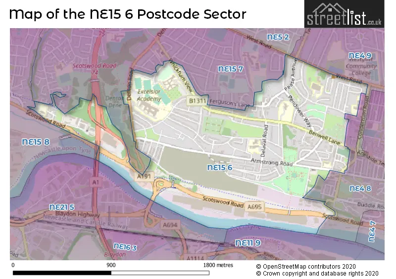
The NE15 6 Postcode shares a border with NE4 8 (NEWCASTLE UPON TYNE), NE4 9 (NEWCASTLE UPON TYNE, Fenham), NE5 2 (NEWCASTLE UPON TYNE, East Denton), NE21 5 (BLAYDON-ON-TYNE, Winlaton), NE15 7 (NEWCASTLE UPON TYNE, Lemington, West Denton) and NE15 8 (NEWCASTLE UPON TYNE, Lemington, Newburn).
The sector is within the post town of NEWCASTLE UPON TYNE.
NE15 6 is a postcode sector within the NE15 postcode district which is within the NE Newcastle upon Tyne postcode area.
The Royal Mail delivery office for the NE15 6 postal sector is the West Delivery Office (ne).
The area of the NE15 6 postcode sector is 1.00 square miles which is 2.59 square kilometres or 639.51 square acres.
The NE15 6 postcode sector is crossed by the A1 Major A road.

Map of the NE15 6 Postcode Sector
Explore the NE15 6 postcode sector by using our free interactive map.
| N | E | 1 | 5 | - | 6 | X | X |
| N | E | 1 | 5 | Space | 6 | Letter | Letter |
Official List of Streets
NEWCASTLE UPON TYNE (88 Streets)
Benwell Grange (1 Streets)
Benwell (1 Streets)
Scotswood (1 Streets)
Unofficial Streets or Alternative Spellings
NEWCASTLE UPON TYNE
ATKINSON ROAD BUDDLE ROAD BURNOPFIELD GARDENS CONHOPE LANE HOWLETT HALL ROAD KINGFISHER BOULEVARD NEPTUNE ROAD NEWMINSTER ROAD ORMISTON OTTRINGHAM CLOSE SWINLEY GARDENS TANTOBIE ROAD TILLMOUTH GARDENS TWO BALL LONNENFenham
GRANGE ROAD BENWELL DENE TERRACE BENWELL GRANGE CLOSE BRIAR PLACE DENTON GARDENS DEVEVAL ROAD FOX AND HOUNDS LANE LANGHAM ROAD MERCIA WAY NUTLEY PLACE OLIVER STREET PARADISE RANMERE ROAD SANDOE GARDENS SCOTSWOOD BRIDGE ST GEORGES ROAD ST GEORGES TERRACE STONEYHURST AVENUEWeather Forecast for NE15 6
Press Button to Show Forecast for Benwell
| Time Period | Icon | Description | Temperature | Rain Probability | Wind |
|---|---|---|---|---|---|
| 12:00 to 15:00 | Cloudy | 7.0°C (feels like 4.0°C) | 9.00% | NE 7 mph | |
| 15:00 to 18:00 | Cloudy | 7.0°C (feels like 5.0°C) | 6.00% | ENE 7 mph | |
| 18:00 to 21:00 | Partly cloudy (day) | 7.0°C (feels like 5.0°C) | 0.00% | E 7 mph | |
| 21:00 to 00:00 | Clear night | 5.0°C (feels like 4.0°C) | 0.00% | ESE 4 mph |
Press Button to Show Forecast for Benwell
| Time Period | Icon | Description | Temperature | Rain Probability | Wind |
|---|---|---|---|---|---|
| 00:00 to 03:00 | Clear night | 4.0°C (feels like 3.0°C) | 0.00% | SW 2 mph | |
| 03:00 to 06:00 | Partly cloudy (night) | 3.0°C (feels like 2.0°C) | 0.00% | NW 2 mph | |
| 06:00 to 09:00 | Partly cloudy (day) | 3.0°C (feels like 1.0°C) | 1.00% | WNW 2 mph | |
| 09:00 to 12:00 | Cloudy | 7.0°C (feels like 5.0°C) | 4.00% | E 4 mph | |
| 12:00 to 15:00 | Cloudy | 8.0°C (feels like 6.0°C) | 9.00% | E 9 mph | |
| 15:00 to 18:00 | Cloudy | 8.0°C (feels like 6.0°C) | 6.00% | E 9 mph | |
| 18:00 to 21:00 | Partly cloudy (day) | 7.0°C (feels like 5.0°C) | 3.00% | ENE 9 mph | |
| 21:00 to 00:00 | Partly cloudy (night) | 6.0°C (feels like 4.0°C) | 3.00% | ENE 7 mph |
Press Button to Show Forecast for Benwell
| Time Period | Icon | Description | Temperature | Rain Probability | Wind |
|---|---|---|---|---|---|
| 00:00 to 03:00 | Cloudy | 6.0°C (feels like 4.0°C) | 5.00% | NNE 4 mph | |
| 03:00 to 06:00 | Cloudy | 5.0°C (feels like 3.0°C) | 14.00% | N 7 mph | |
| 06:00 to 09:00 | Cloudy | 6.0°C (feels like 3.0°C) | 13.00% | N 9 mph | |
| 09:00 to 12:00 | Light rain | 7.0°C (feels like 3.0°C) | 43.00% | N 11 mph | |
| 12:00 to 15:00 | Heavy rain | 7.0°C (feels like 4.0°C) | 78.00% | NNW 11 mph | |
| 15:00 to 18:00 | Light rain | 8.0°C (feels like 5.0°C) | 44.00% | NW 11 mph | |
| 18:00 to 21:00 | Partly cloudy (day) | 9.0°C (feels like 8.0°C) | 8.00% | W 7 mph | |
| 21:00 to 00:00 | Partly cloudy (night) | 7.0°C (feels like 5.0°C) | 2.00% | WSW 9 mph |
Press Button to Show Forecast for Benwell
| Time Period | Icon | Description | Temperature | Rain Probability | Wind |
|---|---|---|---|---|---|
| 00:00 to 03:00 | Clear night | 6.0°C (feels like 3.0°C) | 1.00% | WSW 7 mph | |
| 03:00 to 06:00 | Clear night | 5.0°C (feels like 3.0°C) | 6.00% | SW 7 mph | |
| 06:00 to 09:00 | Partly cloudy (day) | 6.0°C (feels like 3.0°C) | 2.00% | S 9 mph | |
| 09:00 to 12:00 | Partly cloudy (day) | 10.0°C (feels like 8.0°C) | 1.00% | S 11 mph | |
| 12:00 to 15:00 | Cloudy | 13.0°C (feels like 10.0°C) | 6.00% | S 13 mph | |
| 15:00 to 18:00 | Cloudy | 13.0°C (feels like 11.0°C) | 5.00% | S 13 mph | |
| 18:00 to 21:00 | Cloudy | 13.0°C (feels like 10.0°C) | 6.00% | SSE 11 mph | |
| 21:00 to 00:00 | Clear night | 10.0°C (feels like 8.0°C) | 3.00% | SSE 9 mph |
Press Button to Show Forecast for Benwell
| Time Period | Icon | Description | Temperature | Rain Probability | Wind |
|---|---|---|---|---|---|
| 00:00 to 03:00 | Clear night | 9.0°C (feels like 6.0°C) | 1.00% | SSE 9 mph | |
| 03:00 to 06:00 | Clear night | 7.0°C (feels like 5.0°C) | 1.00% | SE 7 mph | |
| 06:00 to 09:00 | Sunny day | 7.0°C (feels like 5.0°C) | 2.00% | SE 7 mph | |
| 09:00 to 12:00 | Partly cloudy (day) | 11.0°C (feels like 9.0°C) | 7.00% | ESE 9 mph | |
| 12:00 to 15:00 | Cloudy | 12.0°C (feels like 10.0°C) | 10.00% | E 11 mph | |
| 15:00 to 18:00 | Cloudy | 12.0°C (feels like 10.0°C) | 11.00% | E 11 mph | |
| 18:00 to 21:00 | Cloudy | 11.0°C (feels like 9.0°C) | 13.00% | E 9 mph | |
| 21:00 to 00:00 | Overcast | 9.0°C (feels like 7.0°C) | 18.00% | E 7 mph |
Schools and Places of Education Within the NE15 6 Postcode Sector
Bridgewater Primary School
Foundation school
Bridgewater, Newcastle-upon-Tyne, Tyne and Wear, NE15 6NL
Head: Mrs Samantha Robson
Ofsted Rating: Outstanding
Inspection: 2013-12-18 (3782 days ago)
Website: Visit Bridgewater Primary School Website
Phone: 01912745290
Number of Pupils: 478
Excelsior Academy
Academy sponsor led
Denton Road, Newcastle-upon-Tyne, Tyne and Wear, NE15 6AF
Head: Mr James Andriot
Ofsted Rating: Requires improvement
Inspection: 2020-03-11 (1507 days ago)
Website: Visit Excelsior Academy Website
Phone: 01912288400
Number of Pupils: 1497
Hadrian School
Foundation special school
Bertram Crescent, Newcastle-upon-Tyne, Tyne and Wear, NE15 6PY
Head: Mr Christopher Rollings
Ofsted Rating: Outstanding
Inspection: 2023-03-29 (394 days ago)
Website: Visit Hadrian School Website
Phone: 01912734440
Number of Pupils: 169
House Prices in the NE15 6 Postcode Sector
| Type of Property | 2018 Average | 2018 Sales | 2017 Average | 2017 Sales | 2016 Average | 2016 Sales | 2015 Average | 2015 Sales |
|---|---|---|---|---|---|---|---|---|
| Detached | £206,397 | 5 | £160,400 | 10 | £176,995 | 10 | £159,531 | 8 |
| Semi-Detached | £124,284 | 42 | £140,461 | 68 | £121,953 | 44 | £124,953 | 49 |
| Terraced | £107,108 | 25 | £105,681 | 37 | £131,434 | 45 | £124,387 | 43 |
| Flats | £91,889 | 13 | £86,108 | 9 | £62,422 | 13 | £75,985 | 7 |
Important Postcodes NE15 6 in the Postcode Sector
NE15 6AF is the postcode for Excelsior Academy, Denton Rd, and Excelsior Academy, Denton Road
NE15 6AU is the postcode for Scotswood Centre, Armstrong Road
NE15 6BY is the postcode for Armstrong Road Health Centre, 460 Armstrong Road
NE15 6JB is the postcode for St. Joseph RC Junior Primary School, Armstrong Road, and St. Joseph RC Primary School, Armstrong Road
NE15 6JJ is the postcode for Newcastle Primary Care Trust, Atkinson Road Clinic, St. James Crescent
NE15 6NL is the postcode for Bridgewater Primary School, Delaval Road, Benwell, and Bridgewater Primary School, Delaval Road
NE15 6PL is the postcode for Jobcentre Plus, Condercum House, 171 West Road
NE15 6PY is the postcode for Hadrian School, Bertram Crescent
NE15 6TT is the postcode for Newcastle College, John Marley Centre, Muscott Grove
NE15 6XX is the postcode for St. Georges RC Primary School, Bells Close
| The NE15 6 Sector is within these Local Authorities |
|
|---|---|
| The NE15 6 Sector is within these Counties |
|
| The NE15 6 Sector is within these Water Company Areas |
|