The NE4 8 postcode sector is within the county of Tyne & Wear.
Did you know? According to the 2021 Census, the NE4 8 postcode sector is home to a bustling 9,494 residents!
Given that each sector allows for 400 unique postcode combinations. Letters C, I, K, M, O and V are not allowed in the last two letters of a postcode. With 151 postcodes already in use, this leaves 249 units available.
The NE4 8 postal code covers the settlement of NEWCASTLE UPON TYNE.
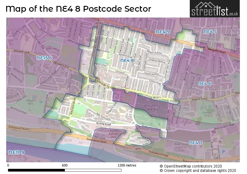
The NE4 8 Postcode shares a border with NE4 5 (NEWCASTLE UPON TYNE, Newcastle Helix), NE4 6 (NEWCASTLE UPON TYNE), NE4 7 (NEWCASTLE UPON TYNE, Elswick, Newcastle Business Park), NE4 9 (NEWCASTLE UPON TYNE, Fenham) and NE15 6 (NEWCASTLE UPON TYNE, Benwell Grange).
The sector is within the post town of NEWCASTLE UPON TYNE.
NE4 8 is a postcode sector within the NE4 postcode district which is within the NE Newcastle upon Tyne postcode area.
The Royal Mail delivery office for the NE4 8 postal sector is the Newcastle Upon Tyne City Delivery Office.
The area of the NE4 8 postcode sector is 0.42 square miles which is 1.10 square kilometres or 270.94 square acres.

Map of the NE4 8 Postcode Sector
Explore the NE4 8 postcode sector by using our free interactive map.
| N | E | 4 | - | 8 | X | X |
| N | E | 4 | Space | 8 | Letter | Letter |
Official List of Streets
NEWCASTLE UPON TYNE (82 Streets)
Grainger Park (1 Streets)
Unofficial Streets or Alternative Spellings
NEWCASTLE UPON TYNE
BENTINCK ROAD BENWELL LANE CAROLINE STREET CONDERCUM ROAD BACK DUNHOLME ROAD EDGEWARE WALK JOSEPH CLOSE KELDANE GARDENS LYNNWOOD AVENUE LYNNWOOD TERRACE OAKFIELD GARDENS SCOTSWOOD ROAD SOUTH BENWELL ROAD WESTMORLAND ROAD WHITEHOUSE ROAD ADELAIDE SHOPPING CENTRE BUDDLE COURT COCHRANE STREET OAKWOOD COURT PARADISE SAINT JOHNS ROAD ST JAMES ROADBenwell
ANGEL VIEW ATHERTON DRIVE LAWSON TERRACEElswick
WEST VIEWNewcastle Business Park
WILLIAM ARMSTRONG DRIVEWeather Forecast for NE4 8
Press Button to Show Forecast for Benwell
| Time Period | Icon | Description | Temperature | Rain Probability | Wind |
|---|---|---|---|---|---|
| 21:00 to 00:00 | Cloudy | 16.0°C (feels like 15.0°C) | 4.00% | SE 7 mph |
Press Button to Show Forecast for Benwell
| Time Period | Icon | Description | Temperature | Rain Probability | Wind |
|---|---|---|---|---|---|
| 00:00 to 03:00 | Cloudy | 15.0°C (feels like 14.0°C) | 5.00% | SE 7 mph | |
| 03:00 to 06:00 | Cloudy | 14.0°C (feels like 12.0°C) | 9.00% | ESE 7 mph | |
| 06:00 to 09:00 | Light rain | 13.0°C (feels like 12.0°C) | 54.00% | ESE 9 mph | |
| 09:00 to 12:00 | Light rain | 13.0°C (feels like 12.0°C) | 66.00% | E 9 mph | |
| 12:00 to 15:00 | Light rain | 14.0°C (feels like 13.0°C) | 65.00% | E 9 mph | |
| 15:00 to 18:00 | Cloudy | 14.0°C (feels like 12.0°C) | 57.00% | E 11 mph | |
| 18:00 to 21:00 | Cloudy | 14.0°C (feels like 13.0°C) | 20.00% | E 9 mph | |
| 21:00 to 00:00 | Cloudy | 14.0°C (feels like 13.0°C) | 11.00% | ESE 4 mph |
Press Button to Show Forecast for Benwell
| Time Period | Icon | Description | Temperature | Rain Probability | Wind |
|---|---|---|---|---|---|
| 00:00 to 03:00 | Cloudy | 13.0°C (feels like 13.0°C) | 12.00% | SE 4 mph | |
| 03:00 to 06:00 | Cloudy | 12.0°C (feels like 12.0°C) | 8.00% | ESE 4 mph | |
| 06:00 to 09:00 | Cloudy | 13.0°C (feels like 12.0°C) | 7.00% | ESE 4 mph | |
| 09:00 to 12:00 | Cloudy | 15.0°C (feels like 14.0°C) | 11.00% | E 4 mph | |
| 12:00 to 15:00 | Cloudy | 16.0°C (feels like 15.0°C) | 14.00% | E 7 mph | |
| 15:00 to 18:00 | Cloudy | 16.0°C (feels like 15.0°C) | 9.00% | ENE 7 mph | |
| 18:00 to 21:00 | Cloudy | 15.0°C (feels like 14.0°C) | 7.00% | ENE 7 mph | |
| 21:00 to 00:00 | Cloudy | 12.0°C (feels like 12.0°C) | 7.00% | ENE 4 mph |
Press Button to Show Forecast for Benwell
| Time Period | Icon | Description | Temperature | Rain Probability | Wind |
|---|---|---|---|---|---|
| 00:00 to 03:00 | Mist | 11.0°C (feels like 11.0°C) | 13.00% | NE 2 mph | |
| 03:00 to 06:00 | Mist | 11.0°C (feels like 10.0°C) | 15.00% | NE 2 mph | |
| 06:00 to 09:00 | Cloudy | 12.0°C (feels like 11.0°C) | 12.00% | NW 4 mph | |
| 09:00 to 12:00 | Overcast | 15.0°C (feels like 14.0°C) | 12.00% | NNE 4 mph | |
| 12:00 to 15:00 | Partly cloudy (day) | 17.0°C (feels like 17.0°C) | 5.00% | NE 4 mph | |
| 15:00 to 18:00 | Partly cloudy (day) | 17.0°C (feels like 15.0°C) | 6.00% | ENE 9 mph | |
| 18:00 to 21:00 | Sunny day | 15.0°C (feels like 14.0°C) | 7.00% | NE 7 mph | |
| 21:00 to 00:00 | Clear night | 12.0°C (feels like 11.0°C) | 4.00% | N 4 mph |
Press Button to Show Forecast for Benwell
| Time Period | Icon | Description | Temperature | Rain Probability | Wind |
|---|---|---|---|---|---|
| 00:00 to 03:00 | Clear night | 11.0°C (feels like 10.0°C) | 4.00% | N 4 mph | |
| 03:00 to 06:00 | Cloudy | 11.0°C (feels like 10.0°C) | 6.00% | NNW 4 mph | |
| 06:00 to 09:00 | Overcast | 12.0°C (feels like 11.0°C) | 11.00% | N 7 mph | |
| 09:00 to 12:00 | Cloudy | 15.0°C (feels like 14.0°C) | 8.00% | N 7 mph | |
| 12:00 to 15:00 | Partly cloudy (day) | 16.0°C (feels like 15.0°C) | 5.00% | NE 9 mph | |
| 15:00 to 18:00 | Partly cloudy (day) | 16.0°C (feels like 14.0°C) | 6.00% | NE 9 mph | |
| 18:00 to 21:00 | Sunny day | 14.0°C (feels like 13.0°C) | 8.00% | NE 9 mph | |
| 21:00 to 00:00 | Clear night | 12.0°C (feels like 11.0°C) | 6.00% | N 7 mph |
Schools and Places of Education Within the NE4 8 Postcode Sector
Atkinson Road Primary Academy
Academy converter
Atkinson Road, Newcastle-upon-Tyne, Tyne and Wear, NE4 8XT
Head: Mrs Lisa Macaulay
Ofsted Rating: Good
Inspection: 2023-05-24 (355 days ago)
Website: Visit Atkinson Road Primary Academy Website
Phone: 01912730452
Number of Pupils: 394
Canning Street Primary School
Foundation school
Wellfield Road, Newcastle-upon-Tyne, Tyne and Wear, NE4 8PA
Head: Mrs Kathryn Herron
Ofsted Rating: Good
Inspection: 2023-09-27 (229 days ago)
Website: Visit Canning Street Primary School Website
Phone: 01912735465
Number of Pupils: 470
St Johns Primary School
Foundation school
Teindland Close, Newcastle-upon-Tyne, Tyne and Wear, NE4 8HE
Head: Mrs Tracey Caffrey
Ofsted Rating: Good
Inspection: 2018-10-11 (2041 days ago)
Website: Visit St Johns Primary School Website
Phone: 01912735293
Number of Pupils: 227
Trinity Academy Newcastle
Academy special converter
Condercum Road, Newcastle-upon-Tyne, Tyne and Wear, NE4 8XJ
Head: Mr Mark Flint
Ofsted Rating: Requires improvement
Inspection: 2023-11-10 (185 days ago)
Website: Visit Trinity Academy Newcastle Website
Phone: 01912986950
Number of Pupils: 191
Trinity Post 16 Solutions Limited
Special post 16 institution
Condercum Road, Newcastle-upon-Tyne, Tyne and Wear, NE4 8XJ
Head: Mrs Sarah Stuart
Ofsted Rating: Good
Inspection: 2023-01-12 (487 days ago)
Website: Visit Trinity Post 16 Solutions Limited Website
Phone: 01912986950
Number of Pupils: 0
Trinity Solutions Academy
Academy converter
Condercum Road, Newcastle-upon-Tyne, Tyne and Wear, NE4 8XJ
Head: Mrs Sarah Stuart
Ofsted Rating: Good
Inspection: 2021-12-09 (886 days ago)
Website: Visit Trinity Solutions Academy Website
Phone: 01912986950
Number of Pupils: 0
West Newcastle Academy
Free schools
Off Armstrong Road, Newcastle-upon-Tyne, Tyne and Wear, NE4 8QP
Head: Miss Susan Percy
Ofsted Rating: Good
Inspection: 2019-06-06 (1803 days ago)
Website: Visit West Newcastle Academy Website
Phone: 01912739477
Number of Pupils: 198
House Prices in the NE4 8 Postcode Sector
| Type of Property | 2018 Average | 2018 Sales | 2017 Average | 2017 Sales | 2016 Average | 2016 Sales | 2015 Average | 2015 Sales |
|---|---|---|---|---|---|---|---|---|
| Detached | £0 | 0 | £0 | 0 | £0 | 0 | £0 | 0 |
| Semi-Detached | £111,875 | 4 | £138,250 | 7 | £127,462 | 13 | £116,154 | 13 |
| Terraced | £86,091 | 22 | £96,850 | 20 | £76,039 | 19 | £85,616 | 29 |
| Flats | £51,262 | 20 | £54,172 | 23 | £41,750 | 12 | £51,462 | 13 |
Important Postcodes NE4 8 in the Postcode Sector
NE4 8AY is the postcode for Prospect Medical Group, 501 Westgate Road
NE4 8HE is the postcode for St. John's Primary School, Teindland Close, and South Benwell Primary School, Teindland Close
NE4 8PA is the postcode for Canning Street Primary School, Wellfield Road
NE4 8RP is the postcode for Northumbria Police, Police Station, Westgate Road
NE4 8RR is the postcode for N T W NHS FOUNDATION TRUST, Silverdale Nursing Home, Grainger Park Road
NE4 8XJ is the postcode for Trinity Oakfield School, Condercum Road
NE4 8XT is the postcode for Atkinson Road Primary School, Atkinson Road, Atkinson Road Nursery School, Atkinson Road, and Atkinson Road Primary Academy, Atkinson Road
| The NE4 8 Sector is within these Local Authorities |
|
|---|---|
| The NE4 8 Sector is within these Counties |
|
| The NE4 8 Sector is within these Water Company Areas |
|