The NE4 6 postcode sector is within the county of Tyne & Wear.
Did you know? According to the 2021 Census, the NE4 6 postcode sector is home to a bustling 7,549 residents!
Given that each sector allows for 400 unique postcode combinations. Letters C, I, K, M, O and V are not allowed in the last two letters of a postcode. With 162 postcodes already in use, this leaves 238 units available.
The NE4 6 postal code covers the settlement of NEWCASTLE UPON TYNE.
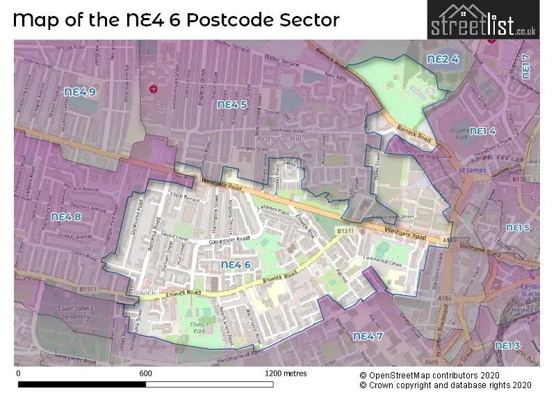
The NE4 6 Postcode shares a border with NE1 4 (NEWCASTLE UPON TYNE), NE2 4 (NEWCASTLE UPON TYNE, Spital Tongues, Jesmond), NE4 5 (NEWCASTLE UPON TYNE, Newcastle Helix), NE4 7 (NEWCASTLE UPON TYNE, Elswick, Newcastle Business Park) and NE4 8 (NEWCASTLE UPON TYNE).
The sector is within the post town of NEWCASTLE UPON TYNE.
NE4 6 is a postcode sector within the NE4 postcode district which is within the NE Newcastle upon Tyne postcode area.
The Royal Mail delivery office for the NE4 6 postal sector is the Newcastle Upon Tyne City Delivery Office.
The area of the NE4 6 postcode sector is 0.43 square miles which is 1.13 square kilometres or 278.28 square acres.

Map of the NE4 6 Postcode Sector
Explore the NE4 6 postcode sector by using our free interactive map.
| N | E | 4 | - | 6 | X | X |
| N | E | 4 | Space | 6 | Letter | Letter |
Official List of Streets
NEWCASTLE UPON TYNE (84 Streets)
Unofficial Streets or Alternative Spellings
NEWCASTLE UPON TYNE
BEACONSFIELD STREET BEECHBURN WALK BLANDFORD SQUARE BRIGHTON GROVE CENTENARY COURT CHELSEA GROVE CORPORATION STREET DERBY COURT DILSTON ROAD GEORGE STREET GRAINGER PARK ROAD HEBER STREET MANSFIELD STREET NORTHCOTE STREET PARK ROAD PITT STREET RYE HILL ST. MICHAELS CLOSE VALLUM WAY VICTORIA STREET WELLINGTON STREETNewcastle Helix
BATH LANE DRAYMANS WAYElswick
JAMES STREETWeather Forecast for NE4 6
Press Button to Show Forecast for St James Park
| Time Period | Icon | Description | Temperature | Rain Probability | Wind |
|---|---|---|---|---|---|
| 09:00 to 12:00 | Cloudy | 7.0°C (feels like 6.0°C) | 5.00% | E 4 mph | |
| 12:00 to 15:00 | Cloudy | 8.0°C (feels like 6.0°C) | 6.00% | E 9 mph | |
| 15:00 to 18:00 | Cloudy | 9.0°C (feels like 6.0°C) | 6.00% | E 9 mph | |
| 18:00 to 21:00 | Partly cloudy (day) | 8.0°C (feels like 5.0°C) | 3.00% | ENE 9 mph | |
| 21:00 to 00:00 | Partly cloudy (night) | 7.0°C (feels like 5.0°C) | 3.00% | ENE 7 mph |
Press Button to Show Forecast for St James Park
| Time Period | Icon | Description | Temperature | Rain Probability | Wind |
|---|---|---|---|---|---|
| 00:00 to 03:00 | Cloudy | 6.0°C (feels like 4.0°C) | 5.00% | NNE 4 mph | |
| 03:00 to 06:00 | Cloudy | 6.0°C (feels like 3.0°C) | 13.00% | N 7 mph | |
| 06:00 to 09:00 | Cloudy | 6.0°C (feels like 3.0°C) | 10.00% | N 11 mph | |
| 09:00 to 12:00 | Light rain | 7.0°C (feels like 3.0°C) | 47.00% | N 13 mph | |
| 12:00 to 15:00 | Heavy rain | 7.0°C (feels like 4.0°C) | 78.00% | NNW 11 mph | |
| 15:00 to 18:00 | Light rain | 8.0°C (feels like 5.0°C) | 51.00% | NW 11 mph | |
| 18:00 to 21:00 | Partly cloudy (day) | 9.0°C (feels like 7.0°C) | 8.00% | WNW 7 mph | |
| 21:00 to 00:00 | Partly cloudy (night) | 7.0°C (feels like 5.0°C) | 2.00% | SW 9 mph |
Press Button to Show Forecast for St James Park
| Time Period | Icon | Description | Temperature | Rain Probability | Wind |
|---|---|---|---|---|---|
| 00:00 to 03:00 | Clear night | 6.0°C (feels like 3.0°C) | 1.00% | SW 9 mph | |
| 03:00 to 06:00 | Clear night | 5.0°C (feels like 2.0°C) | 6.00% | SW 9 mph | |
| 06:00 to 09:00 | Partly cloudy (day) | 6.0°C (feels like 3.0°C) | 2.00% | S 9 mph | |
| 09:00 to 12:00 | Sunny day | 10.0°C (feels like 8.0°C) | 1.00% | S 11 mph | |
| 12:00 to 15:00 | Cloudy | 13.0°C (feels like 10.0°C) | 5.00% | S 13 mph | |
| 15:00 to 18:00 | Cloudy | 14.0°C (feels like 11.0°C) | 5.00% | S 13 mph | |
| 18:00 to 21:00 | Cloudy | 13.0°C (feels like 10.0°C) | 6.00% | SSE 11 mph | |
| 21:00 to 00:00 | Clear night | 10.0°C (feels like 8.0°C) | 3.00% | SSE 11 mph |
Press Button to Show Forecast for St James Park
| Time Period | Icon | Description | Temperature | Rain Probability | Wind |
|---|---|---|---|---|---|
| 00:00 to 03:00 | Clear night | 9.0°C (feels like 7.0°C) | 1.00% | SSE 9 mph | |
| 03:00 to 06:00 | Clear night | 8.0°C (feels like 5.0°C) | 1.00% | SE 9 mph | |
| 06:00 to 09:00 | Sunny day | 8.0°C (feels like 6.0°C) | 2.00% | SE 7 mph | |
| 09:00 to 12:00 | Partly cloudy (day) | 11.0°C (feels like 9.0°C) | 7.00% | ESE 9 mph | |
| 12:00 to 15:00 | Cloudy | 12.0°C (feels like 10.0°C) | 11.00% | E 11 mph | |
| 15:00 to 18:00 | Cloudy | 12.0°C (feels like 10.0°C) | 11.00% | E 11 mph | |
| 18:00 to 21:00 | Cloudy | 11.0°C (feels like 9.0°C) | 13.00% | E 9 mph | |
| 21:00 to 00:00 | Overcast | 9.0°C (feels like 7.0°C) | 18.00% | E 7 mph |
Schools and Places of Education Within the NE4 6 Postcode Sector
Ashfield Nursery School
Local authority nursery school
97-101 Elswick Road, Newcastle-upon-Tyne, Tyne and Wear, NE4 6JR
Head: Mrs Anne Humble
Ofsted Rating: Outstanding
Inspection: 2023-03-28 (396 days ago)
Website: Visit Ashfield Nursery School Website
Phone: 01912735587
Number of Pupils: 102
Bahr Academy
Other independent school
72 Sceptre Street, Newcastle-upon-Tyne, Tyne and Wear, NE4 6PR
Head: Ms Zakiah Chowdhury
Ofsted Rating: Good
Inspection: 2022-01-14 (834 days ago)
Website: Visit Bahr Academy Website
Phone: 01912731907
Number of Pupils: 30
Hawthorn Primary School
Foundation school
Park Close, Newcastle upon Tyne, Tyne and Wear, NE4 6SB
Head: Mrs Jane Dube
Ofsted Rating: Good
Inspection: 2019-02-06 (1907 days ago)
Website: Visit Hawthorn Primary School Website
Phone: 01912734237
Number of Pupils: 208
Our Lady and St Anne's Catholic Primary School
Academy converter
Summerhill Terrace, Newcastle-upon-Tyne, Tyne and Wear, NE4 6EB
Head: Mrs Samantha Henzell
Ofsted Rating: Good
Inspection: 2023-06-14 (318 days ago)
Website: Visit Our Lady and St Anne's Catholic Primary School Website
Phone: 01912325496
Number of Pupils: 233
House Prices in the NE4 6 Postcode Sector
| Type of Property | 2018 Average | 2018 Sales | 2017 Average | 2017 Sales | 2016 Average | 2016 Sales | 2015 Average | 2015 Sales |
|---|---|---|---|---|---|---|---|---|
| Detached | £0 | 0 | £152,500 | 2 | £0 | 0 | £0 | 0 |
| Semi-Detached | £188,783 | 3 | £147,500 | 4 | £174,000 | 4 | £191,125 | 4 |
| Terraced | £148,763 | 19 | £137,642 | 13 | £164,424 | 23 | £167,550 | 15 |
| Flats | £86,060 | 10 | £149,054 | 18 | £65,658 | 12 | £48,458 | 6 |
Important Postcodes NE4 6 in the Postcode Sector
NE4 6BE is the postcode for Westgate Walk-In Centre, Westgate Road, and The Newcastle Upon Tyne Hospitals NHS Foundation Trust, Newcastle General Hospital
NE4 6BT is the postcode for Arthurs Hill Clinic, Douglas Terrace
NE4 6EB is the postcode for Our Lady & St. Annes Primary School, Summerhill Terrace
NE4 6HL is the postcode for Fire Station, Colby Court, Rye Hill Nursery, Colby Court, and Tyne & Wear Fire & Rescue Service, Fire Station, Colby Court
NE4 6NY is the postcode for Westgate Hill Primary School, Westgate Road
NE4 6PR is the postcode for Mill Lane Youth Centre, Sceptre Street
NE4 6SB is the postcode for Hawthorn Primary School, Park Close
NE4 6SH is the postcode for Elswick Health Centre, Meldon Street
NE4 6SQ is the postcode for Elswick Park & Pool, Elswick Road
| The NE4 6 Sector is within these Local Authorities |
|
|---|---|
| The NE4 6 Sector is within these Counties |
|
| The NE4 6 Sector is within these Water Company Areas |
|