The NE4 7 postcode sector is within the county of Tyne & Wear.
Did you know? According to the 2021 Census, the NE4 7 postcode sector is home to a bustling 2,902 residents!
Given that each sector allows for 400 unique postcode combinations. Letters C, I, K, M, O and V are not allowed in the last two letters of a postcode. With 101 postcodes already in use, this leaves 299 units available.
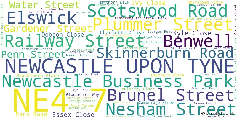
The largest settlement in the NE4 7 postal code is NEWCASTLE UPON TYNE followed by Elswick, and Newcastle Business Park.
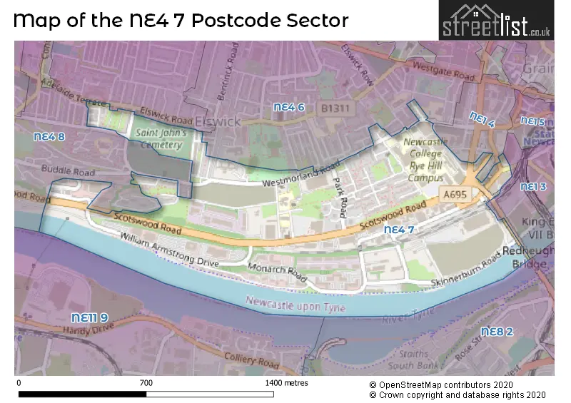
The NE4 7 Postcode shares a border with NE1 3 (NEWCASTLE UPON TYNE), NE1 4 (NEWCASTLE UPON TYNE), NE4 6 (NEWCASTLE UPON TYNE), NE4 8 (NEWCASTLE UPON TYNE) and NE8 2 (GATESHEAD).
The sector is within the post town of NEWCASTLE UPON TYNE.
NE4 7 is a postcode sector within the NE4 postcode district which is within the NE Newcastle upon Tyne postcode area.
The Royal Mail delivery office for the NE4 7 postal sector is the Newcastle Upon Tyne City Delivery Office.
The area of the NE4 7 postcode sector is 0.60 square miles which is 1.56 square kilometres or 386.60 square acres.
Waterways within the NE4 7 postcode sector include the Tyne.

Map of the NE4 7 Postcode Sector
Explore the NE4 7 postcode sector by using our free interactive map.
| N | E | 4 | - | 7 | X | X |
| N | E | 4 | Space | 7 | Letter | Letter |
Official List of Streets
Newcastle Business Park (6 Streets)
Benwell (3 Streets)
NEWCASTLE UPON TYNE (48 Streets)
Elswick (3 Streets)
Unofficial Streets or Alternative Spellings
NEWCASTLE UPON TYNE
AMELIA CLOSE AMELIA WALK BEECH GROVE ROAD BELGRAVE PARADE BUDDLE ROAD CHESTERFIELD ROAD FORTH STREET GOLDFINCH CLOSE HAWTHORN TERRACE HOUSTON STREET KIRKDALE GREEN MARIA STREET NORTHBOURNE STREET POTTERY LANE VIOLET CLOSEWeather Forecast for NE4 7
Press Button to Show Forecast for Low Team
| Time Period | Icon | Description | Temperature | Rain Probability | Wind |
|---|---|---|---|---|---|
| 00:00 to 03:00 | Clear night | 5.0°C (feels like 4.0°C) | 0.00% | SW 2 mph | |
| 03:00 to 06:00 | Partly cloudy (night) | 3.0°C (feels like 2.0°C) | 0.00% | WNW 2 mph | |
| 06:00 to 09:00 | Cloudy | 3.0°C (feels like 2.0°C) | 3.00% | WNW 4 mph | |
| 09:00 to 12:00 | Cloudy | 8.0°C (feels like 6.0°C) | 5.00% | E 4 mph | |
| 12:00 to 15:00 | Cloudy | 9.0°C (feels like 7.0°C) | 9.00% | E 9 mph | |
| 15:00 to 18:00 | Cloudy | 9.0°C (feels like 7.0°C) | 9.00% | E 9 mph | |
| 18:00 to 21:00 | Partly cloudy (day) | 8.0°C (feels like 6.0°C) | 3.00% | ENE 9 mph | |
| 21:00 to 00:00 | Cloudy | 7.0°C (feels like 5.0°C) | 5.00% | ENE 7 mph |
Press Button to Show Forecast for Low Team
| Time Period | Icon | Description | Temperature | Rain Probability | Wind |
|---|---|---|---|---|---|
| 00:00 to 03:00 | Cloudy | 7.0°C (feels like 5.0°C) | 5.00% | NE 4 mph | |
| 03:00 to 06:00 | Cloudy | 6.0°C (feels like 4.0°C) | 13.00% | N 7 mph | |
| 06:00 to 09:00 | Cloudy | 7.0°C (feels like 4.0°C) | 10.00% | N 11 mph | |
| 09:00 to 12:00 | Light rain | 7.0°C (feels like 4.0°C) | 50.00% | N 13 mph | |
| 12:00 to 15:00 | Heavy rain | 8.0°C (feels like 5.0°C) | 76.00% | NNW 13 mph | |
| 15:00 to 18:00 | Light rain | 8.0°C (feels like 6.0°C) | 50.00% | NNW 11 mph | |
| 18:00 to 21:00 | Partly cloudy (day) | 9.0°C (feels like 8.0°C) | 8.00% | WNW 7 mph | |
| 21:00 to 00:00 | Partly cloudy (night) | 8.0°C (feels like 5.0°C) | 2.00% | WSW 9 mph |
Press Button to Show Forecast for Low Team
| Time Period | Icon | Description | Temperature | Rain Probability | Wind |
|---|---|---|---|---|---|
| 00:00 to 03:00 | Clear night | 6.0°C (feels like 4.0°C) | 1.00% | WSW 9 mph | |
| 03:00 to 06:00 | Clear night | 6.0°C (feels like 3.0°C) | 1.00% | SSW 9 mph | |
| 06:00 to 09:00 | Partly cloudy (day) | 6.0°C (feels like 4.0°C) | 2.00% | S 9 mph | |
| 09:00 to 12:00 | Partly cloudy (day) | 10.0°C (feels like 8.0°C) | 1.00% | S 11 mph | |
| 12:00 to 15:00 | Cloudy | 13.0°C (feels like 10.0°C) | 5.00% | S 13 mph | |
| 15:00 to 18:00 | Cloudy | 14.0°C (feels like 11.0°C) | 5.00% | S 13 mph | |
| 18:00 to 21:00 | Cloudy | 13.0°C (feels like 10.0°C) | 5.00% | SSE 11 mph | |
| 21:00 to 00:00 | Clear night | 10.0°C (feels like 8.0°C) | 2.00% | SSE 11 mph |
Press Button to Show Forecast for Low Team
| Time Period | Icon | Description | Temperature | Rain Probability | Wind |
|---|---|---|---|---|---|
| 00:00 to 03:00 | Partly cloudy (night) | 9.0°C (feels like 7.0°C) | 1.00% | SSE 11 mph | |
| 03:00 to 06:00 | Clear night | 8.0°C (feels like 6.0°C) | 1.00% | SE 9 mph | |
| 06:00 to 09:00 | Partly cloudy (day) | 8.0°C (feels like 6.0°C) | 2.00% | SE 9 mph | |
| 09:00 to 12:00 | Cloudy | 10.0°C (feels like 8.0°C) | 9.00% | ESE 9 mph | |
| 12:00 to 15:00 | Cloudy | 11.0°C (feels like 9.0°C) | 9.00% | E 11 mph | |
| 15:00 to 18:00 | Cloudy | 11.0°C (feels like 9.0°C) | 9.00% | E 11 mph | |
| 18:00 to 21:00 | Cloudy | 10.0°C (feels like 8.0°C) | 12.00% | E 11 mph | |
| 21:00 to 00:00 | Overcast | 9.0°C (feels like 7.0°C) | 19.00% | E 9 mph |
Schools and Places of Education Within the NE4 7 Postcode Sector
NCG
Further education
Rye Hill Campus, Newcastle-upon-Tyne, Tyne and Wear, NE4 7SA
Head: Mrs Liz Bromley
Ofsted Rating: Good
Inspection: 2022-01-21 (827 days ago)
Website: Visit NCG Website
Phone: 01912004000
Number of Pupils: 0
St Michael's Catholic Primary School
Academy sponsor led
Clumber Street North, Newcastle-upon-Tyne, Tyne and Wear, NE4 7RE
Head: Mrs Charlotte Chapman
Ofsted Rating: Good
Inspection: 2021-09-22 (948 days ago)
Website: Visit St Michael's Catholic Primary School Website
Phone: 01912739383
Number of Pupils: 229
St Paul's CofE Primary School
Voluntary aided school
Victoria Street, Newcastle-upon-Tyne, Tyne and Wear, NE4 7JU
Head: Mr Jason Cochrane
Ofsted Rating: Requires improvement
Inspection: 2022-11-30 (514 days ago)
Website: Visit St Paul's CofE Primary School Website
Phone: 01912733667
Number of Pupils: 266
House Prices in the NE4 7 Postcode Sector
| Type of Property | 2018 Average | 2018 Sales | 2017 Average | 2017 Sales | 2016 Average | 2016 Sales | 2015 Average | 2015 Sales |
|---|---|---|---|---|---|---|---|---|
| Detached | £0 | 0 | £0 | 0 | £0 | 0 | £0 | 0 |
| Semi-Detached | £80,000 | 1 | £0 | 0 | £137,998 | 2 | £0 | 0 |
| Terraced | £86,000 | 4 | £85,000 | 1 | £130,667 | 3 | £107,575 | 6 |
| Flats | £76,667 | 9 | £77,500 | 4 | £69,840 | 10 | £80,900 | 11 |
Important Postcodes NE4 7 in the Postcode Sector
NE4 7AR is the postcode for Tyneside House, Skinnerburn Road, and Environment Agency, Tyneside House, Skinnerburn Road
NE4 7HX is the postcode for 34-36 Invincible Drive, Armstrong Industrial Park, Newcastle College Cars, 31-33 Armstrong Industrial Park, Invincible Drive, 38-40 Invincible Drive, Armstrong Industrial Park, and 25-27, Invincible Drive, Armstrong Industrial Park
NE4 7JL is the postcode for Newcastle College Teachers Centre, 23-33 George Street
NE4 7JN is the postcode for 45-51, George Street
NE4 7JU is the postcode for St. Pauls C of E Primary School, Victoria Street
NE4 7LJ is the postcode for 6th Form College, Elswick Terrace East, NEWCASTLE COLLEGE, 6TH FORM COLLEGE, ELSWICK TERRACE EAST, Newcastle College Estate Services, 40 Elswick East Terrace, and Newcastle College, 6th Form College
NE4 7QA is the postcode for St. Josephs Home, Westmorland Road
NE4 7RE is the postcode for St. Michaels RC Primary School, Clumber Street North
NE4 7RW is the postcode for Newcastle College, Cruddas Park Shopping Centre, Westmorland Road
NE4 7SA is the postcode for Newcastle College, Mandela Building, Scotswood Road, Newcastle College, Armstrong Building & Higher Education Centre, TREVELYAN HOUSE, Newcastle College, Trevelyan Building, Trevelyan Building, Scotswood Road, Newcastle College, Rye Hill Sports Centre, Rye Hill Campus, Scotswood Road, Parsons Building, Rye Hill Campus, Scotswood Road, Newcastle College, Performance Academy Building, Newcastle College, Rye Hill Sports Centre, HIGHER EDUCATION CENTRE, Newcastle College, Parsons Building, THE PERFORMANCE ACADEMY, RYE HILL CAMPUS, SCOTSWOOD ROAD, Newcastle College, Mandela Building, Newcastle College, Lifestyle Academy Building, Newcastle College, Trevelyan Building, Scotswood Road, Newcastle College, Rutherford Building, Scotswood Road, Rutherford Building, Scotswood Road, Newcastle College, Trevelyan Building, NEWCASTLE COLLEGE, RYE HILL HOUSE, SCOTSWOOD ROAD, Rye Hill Sports Centre, Rye Hill Campus, Scotswood Road, Mandela Building, Scotswood Road, Newcastle College, Rutherford Building, PARSONS ANNEX, Newcastle College, Parsons Building, THE LIFESTYLE ACADEMY, RYE HILL CAMPUS, SCOTSWOOD ROAD, Rye Hill House, Scotswood Road, Newcastle College, Rye Hill House, and Newcastle College, Parsons Building
NE4 7YH is the postcode for Rural Payments Agency, Lancaster House, Hampshire Court, and Department for Environment, Food & Rural Affairs (DEFRA), Rural Payments Agency, Lancaster House, Hampshire Court
NE4 7YL is the postcode for North East Ambulance Service, Scotswood House, Amethyst Road, and Driver and Vehicle Standards Agency, 2 Sirius House, Amethyst Road
| The NE4 7 Sector is within these Local Authorities |
|
|---|---|
| The NE4 7 Sector is within these Counties |
|
| The NE4 7 Sector is within these Water Company Areas |
|