The NE35 9 postcode sector is within the county of Tyne & Wear.
Did you know? According to the 2021 Census, the NE35 9 postcode sector is home to a bustling 6,276 residents!
Given that each sector allows for 400 unique postcode combinations. Letters C, I, K, M, O and V are not allowed in the last two letters of a postcode. With 130 postcodes already in use, this leaves 270 units available.
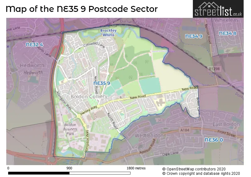
The largest settlements in the NE35 9 postal code are BOLDON COLLIERY and Boldon Business Park.
The NE35 9 Postcode shares a border with NE32 4 (JARROW), NE34 9 (SOUTH SHIELDS) and NE36 0 (EAST BOLDON, West Boldon).
The sector is within the post town of BOLDON COLLIERY.
NE35 9 is a postcode sector within the NE35 postcode district which is within the NE Newcastle upon Tyne postcode area.
The Royal Mail delivery office for the NE35 9 postal sector is the Jarrow Delivery Office.
The area of the NE35 9 postcode sector is 1.11 square miles which is 2.86 square kilometres or 707.64 square acres.
The NE35 9 postcode sector is crossed by the A19 Major A road.
Waterways within the NE35 9 postcode sector include the Don.

Map of the NE35 9 Postcode Sector
Explore the NE35 9 postcode sector by using our free interactive map.
| N | E | 3 | 5 | - | 9 | X | X |
| N | E | 3 | 5 | Space | 9 | Letter | Letter |
Official List of Streets
BOLDON COLLIERY (88 Streets)
Boldon Business Park (5 Streets)
Unofficial Streets or Alternative Spellings
EAST BOLDON
BOKER LANE LILBURN CLOSEWest Boldon
HINDMARCH DRIVE NEWCASTLE ROAD OWEN DRIVE BOLDON COURT CALDER GREEN COLLERY MEWS COTSWOLD LANE FRONT STREET HENLEY WAY REAR HEDWORTH LANE REAR STATION ROAD REAR THE TERRACE TESTOS ROUNDABOUT TOPPING STREETBOLDON COLLIERY,
HEDWORTH LANEWeather Forecast for NE35 9
Press Button to Show Forecast for Boldon Colliery
| Time Period | Icon | Description | Temperature | Rain Probability | Wind |
|---|---|---|---|---|---|
| 12:00 to 15:00 | Overcast | 7.0°C (feels like 4.0°C) | 8.00% | NE 7 mph | |
| 15:00 to 18:00 | Cloudy | 8.0°C (feels like 5.0°C) | 8.00% | ENE 9 mph | |
| 18:00 to 21:00 | Sunny day | 7.0°C (feels like 5.0°C) | 0.00% | E 7 mph | |
| 21:00 to 00:00 | Clear night | 6.0°C (feels like 5.0°C) | 0.00% | E 4 mph |
Press Button to Show Forecast for Boldon Colliery
| Time Period | Icon | Description | Temperature | Rain Probability | Wind |
|---|---|---|---|---|---|
| 00:00 to 03:00 | Clear night | 5.0°C (feels like 4.0°C) | 0.00% | SW 2 mph | |
| 03:00 to 06:00 | Clear night | 4.0°C (feels like 2.0°C) | 1.00% | NW 4 mph | |
| 06:00 to 09:00 | Partly cloudy (day) | 4.0°C (feels like 2.0°C) | 0.00% | NNW 4 mph | |
| 09:00 to 12:00 | Cloudy | 8.0°C (feels like 6.0°C) | 5.00% | ENE 7 mph | |
| 12:00 to 15:00 | Cloudy | 8.0°C (feels like 6.0°C) | 13.00% | ENE 9 mph | |
| 15:00 to 18:00 | Cloudy | 8.0°C (feels like 6.0°C) | 5.00% | E 9 mph | |
| 18:00 to 21:00 | Cloudy | 8.0°C (feels like 5.0°C) | 6.00% | ENE 9 mph | |
| 21:00 to 00:00 | Cloudy | 7.0°C (feels like 5.0°C) | 4.00% | ENE 7 mph |
Press Button to Show Forecast for Boldon Colliery
| Time Period | Icon | Description | Temperature | Rain Probability | Wind |
|---|---|---|---|---|---|
| 00:00 to 03:00 | Cloudy | 6.0°C (feels like 4.0°C) | 5.00% | NE 7 mph | |
| 03:00 to 06:00 | Cloudy | 6.0°C (feels like 3.0°C) | 8.00% | NNE 9 mph | |
| 06:00 to 09:00 | Cloudy | 7.0°C (feels like 3.0°C) | 7.00% | N 13 mph | |
| 09:00 to 12:00 | Light rain | 7.0°C (feels like 3.0°C) | 56.00% | N 16 mph | |
| 12:00 to 15:00 | Heavy rain | 8.0°C (feels like 4.0°C) | 76.00% | NNW 16 mph | |
| 15:00 to 18:00 | Light rain | 8.0°C (feels like 5.0°C) | 50.00% | NNW 13 mph | |
| 18:00 to 21:00 | Partly cloudy (day) | 9.0°C (feels like 7.0°C) | 8.00% | W 7 mph | |
| 21:00 to 00:00 | Cloudy | 7.0°C (feels like 5.0°C) | 5.00% | SW 9 mph |
Press Button to Show Forecast for Boldon Colliery
| Time Period | Icon | Description | Temperature | Rain Probability | Wind |
|---|---|---|---|---|---|
| 00:00 to 03:00 | Clear night | 6.0°C (feels like 3.0°C) | 1.00% | SW 9 mph | |
| 03:00 to 06:00 | Clear night | 5.0°C (feels like 2.0°C) | 1.00% | SW 9 mph | |
| 06:00 to 09:00 | Partly cloudy (day) | 6.0°C (feels like 3.0°C) | 2.00% | S 11 mph | |
| 09:00 to 12:00 | Partly cloudy (day) | 10.0°C (feels like 7.0°C) | 1.00% | S 13 mph | |
| 12:00 to 15:00 | Cloudy | 13.0°C (feels like 10.0°C) | 5.00% | S 13 mph | |
| 15:00 to 18:00 | Cloudy | 13.0°C (feels like 10.0°C) | 5.00% | S 13 mph | |
| 18:00 to 21:00 | Partly cloudy (day) | 12.0°C (feels like 10.0°C) | 3.00% | SSE 13 mph | |
| 21:00 to 00:00 | Partly cloudy (night) | 10.0°C (feels like 7.0°C) | 2.00% | SSE 13 mph |
Press Button to Show Forecast for Boldon Colliery
| Time Period | Icon | Description | Temperature | Rain Probability | Wind |
|---|---|---|---|---|---|
| 00:00 to 03:00 | Partly cloudy (night) | 9.0°C (feels like 6.0°C) | 1.00% | SSE 11 mph | |
| 03:00 to 06:00 | Clear night | 8.0°C (feels like 5.0°C) | 1.00% | SE 9 mph | |
| 06:00 to 09:00 | Cloudy | 8.0°C (feels like 6.0°C) | 6.00% | SE 9 mph | |
| 09:00 to 12:00 | Cloudy | 10.0°C (feels like 8.0°C) | 7.00% | ESE 9 mph | |
| 12:00 to 15:00 | Cloudy | 11.0°C (feels like 9.0°C) | 10.00% | E 11 mph | |
| 15:00 to 18:00 | Overcast | 11.0°C (feels like 8.0°C) | 12.00% | E 11 mph | |
| 18:00 to 21:00 | Cloudy | 10.0°C (feels like 7.0°C) | 8.00% | E 11 mph | |
| 21:00 to 00:00 | Overcast | 9.0°C (feels like 7.0°C) | 13.00% | E 9 mph |
Schools and Places of Education Within the NE35 9 Postcode Sector
Boldon Nursery School
Local authority nursery school
Reginald Street, Boldon Colliery, Tyne and Wear, NE35 9DG
Head: Miss Lisa Walton
Ofsted Rating: Outstanding
Inspection: 2019-03-05 (1879 days ago)
Website: Visit Boldon Nursery School Website
Phone: 01915363669
Number of Pupils: 71
Boldon School
Community school
New Road, Boldon Colliery, Tyne and Wear, NE35 9DZ
Head: Mrs Louise Pippin
Ofsted Rating: Good
Inspection: 2019-09-19 (1681 days ago)
Website: Visit Boldon School Website
Phone: 01915362176
Number of Pupils: 1032
Hedworth Lane Primary School
Community school
Hedworth Lane, Boldon Colliery, Tyne and Wear, NE35 9JB
Head: Mrs Claire Hutchinson
Ofsted Rating: Good
Inspection: 2018-10-16 (2019 days ago)
Website: Visit Hedworth Lane Primary School Website
Phone: 01915367262
Number of Pupils: 301
House Prices in the NE35 9 Postcode Sector
| Type of Property | 2018 Average | 2018 Sales | 2017 Average | 2017 Sales | 2016 Average | 2016 Sales | 2015 Average | 2015 Sales |
|---|---|---|---|---|---|---|---|---|
| Detached | £233,282 | 14 | £231,379 | 17 | £210,068 | 22 | £216,946 | 20 |
| Semi-Detached | £151,663 | 24 | £153,199 | 20 | £132,434 | 25 | £139,228 | 34 |
| Terraced | £113,045 | 21 | £101,327 | 26 | £97,082 | 28 | £91,072 | 27 |
| Flats | £75,667 | 3 | £88,875 | 8 | £92,167 | 3 | £46,000 | 3 |
Important Postcodes NE35 9 in the Postcode Sector
NE35 9AN is the postcode for The Medical Centre, Gibson Court
NE35 9DG is the postcode for Boldon Nursery, Reginald Street
NE35 9DS is the postcode for Boldon Community Association, New Road
NE35 9DZ is the postcode for Boldon School, New Road, and Boldon Community Centre, New Road
NE35 9JB is the postcode for Hedworth Lane County Infant School, Hedworth Lane
NE35 9LN is the postcode for ESTATES UNIT B, Sunderland NHS Estates, Unit 4-6, Bensham Street, and ESTATES UNIT A, Sunderland NHS Estates, Unit 4-6, Bensham Street
| The NE35 9 Sector is within these Local Authorities |
|
|---|---|
| The NE35 9 Sector is within these Counties |
|
| The NE35 9 Sector is within these Water Company Areas |
|