The NE9 7 postcode sector is within the county of Tyne & Wear.
Did you know? According to the 2021 Census, the NE9 7 postcode sector is home to a bustling 11,191 residents!
Given that each sector allows for 400 unique postcode combinations. Letters C, I, K, M, O and V are not allowed in the last two letters of a postcode. With 275 postcodes already in use, this leaves 125 units available.
The largest settlement in the NE9 7 postal code is GATESHEAD followed by Springwell, and Wrekenton.
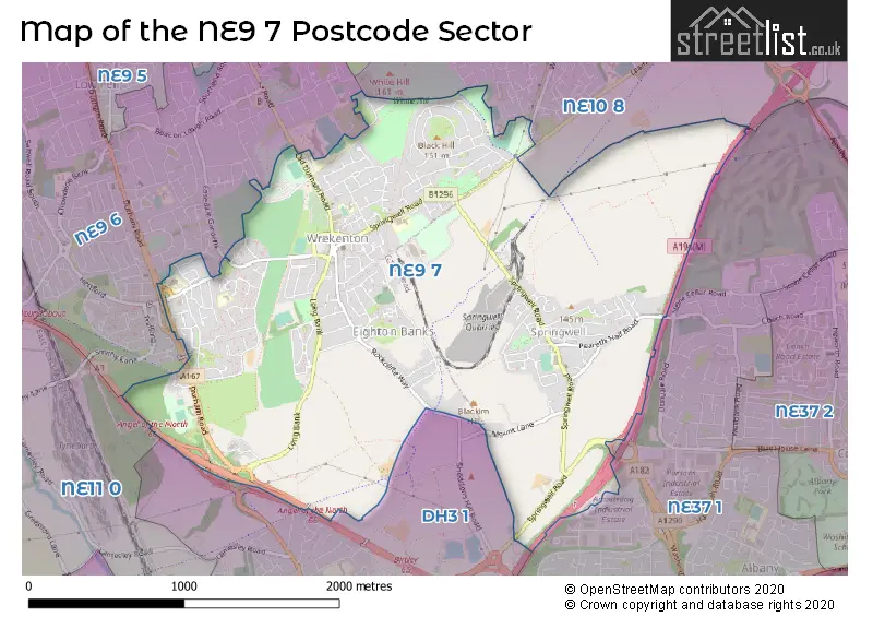
The NE9 7 Postcode shares a border with NE10 8 (GATESHEAD, Wardley), NE11 0 (GATESHEAD, Team Valley Trading Estate, Kibblesworth), NE9 6 (GATESHEAD, Low Fell), NE37 1 (WASHINGTON, Armstrong) and DH3 1 (Birtley).
The sector is within the post town of GATESHEAD.
NE9 7 is a postcode sector within the NE9 postcode district which is within the NE Newcastle upon Tyne postcode area.
The Royal Mail delivery office for the NE9 7 postal sector is the Valley Delivery Office.
The area of the NE9 7 postcode sector is 2.67 square miles which is 6.92 square kilometres or 1,708.83 square acres.
The NE9 7 postcode sector is crossed by the A194M Major A road.
The NE9 7 postcode sector is crossed by the A1 Major A road.

Map of the NE9 7 Postcode Sector
Explore the NE9 7 postcode sector by using our free interactive map.
| N | E | 9 | - | 7 | X | X |
| N | E | 9 | Space | 7 | Letter | Letter |
Official List of Streets
GATESHEAD (168 Streets)
Springwell (24 Streets)
Harlow Green (1 Streets)
Eighton Banks (5 Streets)
Wrekenton (4 Streets)
Springwell Village (2 Streets)
Unofficial Streets or Alternative Spellings
GATESHEAD
BORROWDALE GARDENS HERTFORD LARKSPUR LEAM LANE OLD DURHAM ROAD STANEWAY WEALCROFTArmstrong
DONKIN ROADGATESHEAD,
PEARETH HALL ROAD BOWES RAILWAY PATH CAMPGROUND HOUSEHOLD WASTE AND RECYCLING CENTRE HAREBELL ROAD HAREWOOD GROVE HARLOW GREEN HAVANNAH INTERCHANGE LISMOR TERRACE MOUNT ROAD SKIPTON GROVE THE ANGEL CYCLEWAY WHITEHOUSE LANE WINDSOR ROADWeather Forecast for NE9 7
Press Button to Show Forecast for Birtley
| Time Period | Icon | Description | Temperature | Rain Probability | Wind |
|---|---|---|---|---|---|
| 12:00 to 15:00 | Partly cloudy (day) | 20.0°C (feels like 18.0°C) | 0.00% | SSE 13 mph | |
| 15:00 to 18:00 | Partly cloudy (day) | 21.0°C (feels like 18.0°C) | 0.00% | SSE 13 mph | |
| 18:00 to 21:00 | Cloudy | 19.0°C (feels like 17.0°C) | 4.00% | SE 9 mph | |
| 21:00 to 00:00 | Cloudy | 16.0°C (feels like 15.0°C) | 5.00% | SE 9 mph |
Press Button to Show Forecast for Birtley
| Time Period | Icon | Description | Temperature | Rain Probability | Wind |
|---|---|---|---|---|---|
| 00:00 to 03:00 | Cloudy | 15.0°C (feels like 14.0°C) | 4.00% | SE 9 mph | |
| 03:00 to 06:00 | Cloudy | 13.0°C (feels like 12.0°C) | 9.00% | ESE 7 mph | |
| 06:00 to 09:00 | Light rain | 13.0°C (feels like 11.0°C) | 57.00% | ESE 9 mph | |
| 09:00 to 12:00 | Heavy rain | 13.0°C (feels like 11.0°C) | 88.00% | E 9 mph | |
| 12:00 to 15:00 | Heavy rain | 14.0°C (feels like 12.0°C) | 86.00% | E 11 mph | |
| 15:00 to 18:00 | Light rain | 14.0°C (feels like 12.0°C) | 59.00% | ESE 11 mph | |
| 18:00 to 21:00 | Cloudy | 14.0°C (feels like 13.0°C) | 21.00% | ESE 9 mph | |
| 21:00 to 00:00 | Cloudy | 13.0°C (feels like 13.0°C) | 11.00% | ESE 7 mph |
Press Button to Show Forecast for Birtley
| Time Period | Icon | Description | Temperature | Rain Probability | Wind |
|---|---|---|---|---|---|
| 00:00 to 03:00 | Cloudy | 13.0°C (feels like 13.0°C) | 13.00% | SE 4 mph | |
| 03:00 to 06:00 | Cloudy | 12.0°C (feels like 12.0°C) | 8.00% | SE 4 mph | |
| 06:00 to 09:00 | Cloudy | 13.0°C (feels like 13.0°C) | 7.00% | SE 4 mph | |
| 09:00 to 12:00 | Cloudy | 14.0°C (feels like 14.0°C) | 12.00% | E 4 mph | |
| 12:00 to 15:00 | Light rain shower (day) | 15.0°C (feels like 14.0°C) | 32.00% | ENE 7 mph | |
| 15:00 to 18:00 | Partly cloudy (day) | 15.0°C (feels like 14.0°C) | 6.00% | ENE 7 mph | |
| 18:00 to 21:00 | Cloudy | 14.0°C (feels like 13.0°C) | 8.00% | ENE 4 mph | |
| 21:00 to 00:00 | Cloudy | 12.0°C (feels like 12.0°C) | 7.00% | NE 4 mph |
Press Button to Show Forecast for Birtley
| Time Period | Icon | Description | Temperature | Rain Probability | Wind |
|---|---|---|---|---|---|
| 00:00 to 03:00 | Partly cloudy (night) | 11.0°C (feels like 11.0°C) | 4.00% | NE 4 mph | |
| 03:00 to 06:00 | Cloudy | 11.0°C (feels like 10.0°C) | 7.00% | ENE 4 mph | |
| 06:00 to 09:00 | Cloudy | 12.0°C (feels like 11.0°C) | 10.00% | WNW 4 mph | |
| 09:00 to 12:00 | Cloudy | 14.0°C (feels like 14.0°C) | 8.00% | NNE 4 mph | |
| 12:00 to 15:00 | Partly cloudy (day) | 16.0°C (feels like 15.0°C) | 5.00% | NE 7 mph | |
| 15:00 to 18:00 | Partly cloudy (day) | 16.0°C (feels like 15.0°C) | 6.00% | ENE 9 mph | |
| 18:00 to 21:00 | Partly cloudy (day) | 15.0°C (feels like 14.0°C) | 7.00% | NE 7 mph | |
| 21:00 to 00:00 | Partly cloudy (night) | 12.0°C (feels like 11.0°C) | 4.00% | N 7 mph |
Press Button to Show Forecast for Birtley
| Time Period | Icon | Description | Temperature | Rain Probability | Wind |
|---|---|---|---|---|---|
| 00:00 to 03:00 | Partly cloudy (night) | 12.0°C (feels like 11.0°C) | 4.00% | NNW 4 mph | |
| 03:00 to 06:00 | Cloudy | 11.0°C (feels like 10.0°C) | 6.00% | NNW 7 mph | |
| 06:00 to 09:00 | Cloudy | 12.0°C (feels like 11.0°C) | 8.00% | NNW 7 mph | |
| 09:00 to 12:00 | Overcast | 14.0°C (feels like 13.0°C) | 11.00% | N 7 mph | |
| 12:00 to 15:00 | Partly cloudy (day) | 16.0°C (feels like 15.0°C) | 5.00% | NNE 9 mph | |
| 15:00 to 18:00 | Cloudy | 15.0°C (feels like 14.0°C) | 9.00% | NNE 9 mph | |
| 18:00 to 21:00 | Partly cloudy (day) | 14.0°C (feels like 13.0°C) | 8.00% | NE 7 mph | |
| 21:00 to 00:00 | Partly cloudy (night) | 12.0°C (feels like 11.0°C) | 7.00% | NNE 7 mph |
Schools and Places of Education Within the NE9 7 Postcode Sector
Fell Dyke Community Primary School
Community school
Springwell Road, Gateshead, Tyne and Wear, NE9 7AA
Head: Ms Kate Savage
Ofsted Rating: Good
Inspection: 2022-12-09 (521 days ago)
Website: Visit Fell Dyke Community Primary School Website
Phone: 01914334111
Number of Pupils: 283
Harlow Green Community Primary School
Community school
Harlow Green Lane, Gateshead, Tyne and Wear, NE9 7TB
Head: Mr Mustafaa Malik
Ofsted Rating: Good
Inspection: 2023-02-15 (453 days ago)
Website: Visit Harlow Green Community Primary School Website
Phone: 01914876703
Number of Pupils: 401
Springwell Village Primary School
Academy converter
Westfield Crescent, Gateshead, Tyne and Wear, NE9 7RX
Head: Miss Bryony Parrish
Ofsted Rating: Good
Inspection: 2023-02-08 (460 days ago)
Website: Visit Springwell Village Primary School Website
Phone: 01914157214
Number of Pupils: 206
St Anne's Catholic Primary School, Harlow Green
Academy converter
Off Pickering Green, Gateshead, Tyne and Wear, NE9 7HX
Head: Mrs Lisa Stokoe
Ofsted Rating: Good
Inspection: 2023-05-05 (374 days ago)
Website: Visit St Anne's Catholic Primary School, Harlow Green Website
Phone: 01914334053
Number of Pupils: 137
House Prices in the NE9 7 Postcode Sector
| Type of Property | 2018 Average | 2018 Sales | 2017 Average | 2017 Sales | 2016 Average | 2016 Sales | 2015 Average | 2015 Sales |
|---|---|---|---|---|---|---|---|---|
| Detached | £220,577 | 13 | £249,667 | 9 | £291,396 | 12 | £208,825 | 19 |
| Semi-Detached | £150,682 | 36 | £135,147 | 37 | £156,438 | 34 | £146,391 | 39 |
| Terraced | £121,501 | 64 | £113,112 | 56 | £103,974 | 71 | £104,630 | 57 |
| Flats | £70,800 | 5 | £82,071 | 7 | £39,419 | 4 | £61,269 | 8 |
Important Postcodes NE9 7 in the Postcode Sector
NE9 7AA is the postcode for Felldyke Primary & Infant School, Springwell Road
NE9 7AD is the postcode for Wrekenton Health Centre, Springwell Road
NE9 7HX is the postcode for St. Annes Catholic Primary School, Black Lane
NE9 7JR is the postcode for Wrekenton Hub, High Street
NE9 7LH is the postcode for St. Oswalds RC Infant & Junior School, Easington Avenue
NE9 7RX is the postcode for Springwell Village Primary School, Westfield Crescent
NE9 7TB is the postcode for Harlow Green Community Primary School, Harlow Green Lane
NE9 7TG is the postcode for ANGEL COURT, WAVERLEY ROAD, HARLOW GREEN, and Angel Court, Waverley Road
NE9 7TU is the postcode for Chowdene Children's Centre, Waverley Road
| The NE9 7 Sector is within these Local Authorities |
|
|---|---|
| The NE9 7 Sector is within these Counties |
|
| The NE9 7 Sector is within these Water Company Areas |
|