The NE10 8 postcode sector is within the county of Tyne & Wear.
Did you know? According to the 2021 Census, the NE10 8 postcode sector is home to a bustling 17,035 residents!
Given that each sector allows for 400 unique postcode combinations. Letters C, I, K, M, O and V are not allowed in the last two letters of a postcode. With 303 postcodes already in use, this leaves 97 units available.
The largest settlements in the NE10 8 postal code are GATESHEAD and Wardley.
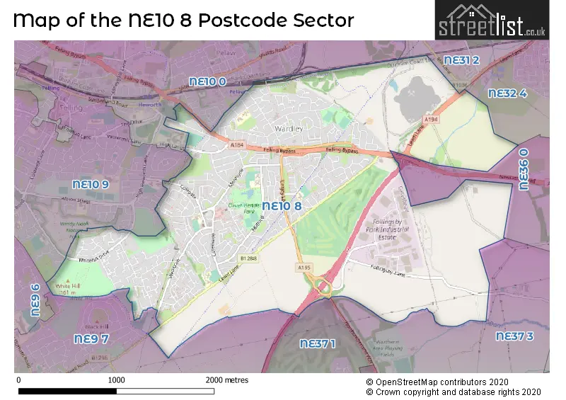
The NE10 8 Postcode shares a border with NE10 9 (GATESHEAD, Felling, Windy Nook), NE31 2 (HEBBURN, Monkton Business Park South), NE32 4 (JARROW), NE37 3 (WASHINGTON), NE9 6 (GATESHEAD, Low Fell), NE9 7 (GATESHEAD, Springwell, Wrekenton), NE10 0 (GATESHEAD, Pelaw, Bill Quay), NE36 0 (EAST BOLDON, West Boldon) and NE37 1 (WASHINGTON, Armstrong).
The sector is within the post town of GATESHEAD.
NE10 8 is a postcode sector within the NE10 postcode district which is within the NE Newcastle upon Tyne postcode area.
The Royal Mail delivery office for the NE10 8 postal sector is the Gateshead Delivery Office.
The area of the NE10 8 postcode sector is 3.28 square miles which is 8.50 square kilometres or 2,099.69 square acres.
The NE10 8 postcode sector is crossed by the A184 Major A road.
The NE10 8 postcode sector is crossed by the A194M Major A road.

Map of the NE10 8 Postcode Sector
Explore the NE10 8 postcode sector by using our free interactive map.
| N | E | 1 | 0 | - | 8 | X | X |
| N | E | 1 | 0 | Space | 8 | Letter | Letter |
Official List of Streets
GATESHEAD (205 Streets)
Unofficial Streets or Alternative Spellings
GATESHEAD
CAMPION GARDENS COLEGATE WEST CONISTON WHITEHILL DRIVEJARROW
LEAM LANEWeather Forecast for NE10 8
Press Button to Show Forecast for Felling
| Time Period | Icon | Description | Temperature | Rain Probability | Wind |
|---|---|---|---|---|---|
| 21:00 to 00:00 | Clear night | 6.0°C (feels like 4.0°C) | 0.00% | E 4 mph |
Press Button to Show Forecast for Felling
| Time Period | Icon | Description | Temperature | Rain Probability | Wind |
|---|---|---|---|---|---|
| 00:00 to 03:00 | Partly cloudy (night) | 5.0°C (feels like 4.0°C) | 0.00% | SW 2 mph | |
| 03:00 to 06:00 | Clear night | 3.0°C (feels like 2.0°C) | 1.00% | W 2 mph | |
| 06:00 to 09:00 | Cloudy | 3.0°C (feels like 2.0°C) | 3.00% | WNW 2 mph | |
| 09:00 to 12:00 | Cloudy | 7.0°C (feels like 5.0°C) | 8.00% | ENE 4 mph | |
| 12:00 to 15:00 | Cloudy | 8.0°C (feels like 6.0°C) | 5.00% | ENE 9 mph | |
| 15:00 to 18:00 | Cloudy | 8.0°C (feels like 6.0°C) | 6.00% | ENE 9 mph | |
| 18:00 to 21:00 | Partly cloudy (day) | 7.0°C (feels like 5.0°C) | 3.00% | ENE 9 mph | |
| 21:00 to 00:00 | Partly cloudy (night) | 7.0°C (feels like 5.0°C) | 3.00% | ENE 7 mph |
Press Button to Show Forecast for Felling
| Time Period | Icon | Description | Temperature | Rain Probability | Wind |
|---|---|---|---|---|---|
| 00:00 to 03:00 | Cloudy | 6.0°C (feels like 4.0°C) | 5.00% | NNE 4 mph | |
| 03:00 to 06:00 | Cloudy | 6.0°C (feels like 3.0°C) | 8.00% | NNE 7 mph | |
| 06:00 to 09:00 | Cloudy | 6.0°C (feels like 3.0°C) | 12.00% | N 11 mph | |
| 09:00 to 12:00 | Light rain | 7.0°C (feels like 3.0°C) | 51.00% | N 13 mph | |
| 12:00 to 15:00 | Heavy rain | 7.0°C (feels like 4.0°C) | 78.00% | NNW 13 mph | |
| 15:00 to 18:00 | Light rain | 8.0°C (feels like 5.0°C) | 51.00% | NW 11 mph | |
| 18:00 to 21:00 | Partly cloudy (day) | 9.0°C (feels like 7.0°C) | 8.00% | WNW 7 mph | |
| 21:00 to 00:00 | Partly cloudy (night) | 7.0°C (feels like 5.0°C) | 2.00% | SW 9 mph |
Press Button to Show Forecast for Felling
| Time Period | Icon | Description | Temperature | Rain Probability | Wind |
|---|---|---|---|---|---|
| 00:00 to 03:00 | Clear night | 6.0°C (feels like 3.0°C) | 1.00% | SW 9 mph | |
| 03:00 to 06:00 | Clear night | 5.0°C (feels like 2.0°C) | 0.00% | SSW 9 mph | |
| 06:00 to 09:00 | Partly cloudy (day) | 6.0°C (feels like 3.0°C) | 2.00% | S 9 mph | |
| 09:00 to 12:00 | Sunny day | 10.0°C (feels like 8.0°C) | 1.00% | S 11 mph | |
| 12:00 to 15:00 | Cloudy | 13.0°C (feels like 10.0°C) | 5.00% | S 13 mph | |
| 15:00 to 18:00 | Cloudy | 14.0°C (feels like 11.0°C) | 5.00% | S 13 mph | |
| 18:00 to 21:00 | Cloudy | 13.0°C (feels like 10.0°C) | 6.00% | SSE 11 mph | |
| 21:00 to 00:00 | Clear night | 10.0°C (feels like 8.0°C) | 3.00% | SSE 11 mph |
Press Button to Show Forecast for Felling
| Time Period | Icon | Description | Temperature | Rain Probability | Wind |
|---|---|---|---|---|---|
| 00:00 to 03:00 | Clear night | 9.0°C (feels like 7.0°C) | 1.00% | SSE 9 mph | |
| 03:00 to 06:00 | Clear night | 8.0°C (feels like 5.0°C) | 1.00% | SE 9 mph | |
| 06:00 to 09:00 | Sunny day | 8.0°C (feels like 6.0°C) | 2.00% | SE 7 mph | |
| 09:00 to 12:00 | Partly cloudy (day) | 11.0°C (feels like 9.0°C) | 7.00% | ESE 9 mph | |
| 12:00 to 15:00 | Cloudy | 12.0°C (feels like 10.0°C) | 11.00% | E 11 mph | |
| 15:00 to 18:00 | Cloudy | 12.0°C (feels like 10.0°C) | 11.00% | E 11 mph | |
| 18:00 to 21:00 | Cloudy | 11.0°C (feels like 9.0°C) | 13.00% | E 9 mph | |
| 21:00 to 00:00 | Overcast | 9.0°C (feels like 8.0°C) | 18.00% | E 7 mph |
Schools and Places of Education Within the NE10 8 Postcode Sector
Hill Top School
Community special school
Wealcroft, Gateshead, Tyne and Wear, NE10 8LT
Head: Ms Anita Bell
Ofsted Rating: Good
Inspection: 2018-06-05 (2152 days ago)
Website: Visit Hill Top School Website
Phone: 01914692462
Number of Pupils: 131
Lingey House Primary School
Community school
Millford, Gateshead, Tyne and Wear, NE10 8DN
Head: Mrs Chloe Wilkinson
Ofsted Rating: Outstanding
Inspection: 2009-05-19 (5456 days ago)
Website: Visit Lingey House Primary School Website
Phone: 01914381287
Number of Pupils: 462
Roman Road Primary School
Community school
Leam Lane Estate, Gateshead, Tyne and Wear, NE10 8SA
Head: Mrs Carole Jones
Ofsted Rating: Good
Inspection: 2023-03-13 (410 days ago)
Website: Visit Roman Road Primary School Website
Phone: 01914380510
Number of Pupils: 230
Wardley Primary School
Community school
Keir Hardie Avenue, Gateshead, Tyne and Wear, NE10 8TX
Head: Ms Nicola Wallace
Ofsted Rating: Good
Inspection: 2022-02-02 (814 days ago)
Website: Visit Wardley Primary School Website
Phone: 01914693012
Number of Pupils: 259
White Mere Community Primary School
Community school
Sherburn Way, Gateshead, Tyne and Wear, NE10 8BA
Head: Mr John Archer
Ofsted Rating: Good
Inspection: 2023-10-19 (190 days ago)
Website: Visit White Mere Community Primary School Website
Phone: 01914385008
Number of Pupils: 153
House Prices in the NE10 8 Postcode Sector
| Type of Property | 2018 Average | 2018 Sales | 2017 Average | 2017 Sales | 2016 Average | 2016 Sales | 2015 Average | 2015 Sales |
|---|---|---|---|---|---|---|---|---|
| Detached | £219,980 | 25 | £209,799 | 28 | £197,495 | 20 | £198,200 | 15 |
| Semi-Detached | £124,914 | 128 | £120,143 | 127 | £110,783 | 125 | £111,830 | 106 |
| Terraced | £103,055 | 41 | £101,007 | 45 | £103,960 | 48 | £107,603 | 33 |
| Flats | £73,800 | 5 | £65,850 | 10 | £54,750 | 12 | £46,433 | 15 |
Important Postcodes NE10 8 in the Postcode Sector
NE10 8BA is the postcode for White Mere Community Primary School, Leam Lane
NE10 8DN is the postcode for JUNIOR BLOCK, Lingey House Primary School, Millford, Lingey House Primary School, Milford, and Lingey House Primary School, Millford
NE10 8DX is the postcode for Gateshead Health Care, Grassbanks Health Centre, Grassbanks, and Grassbanks Health Centre and Keegan Court, Grassbanks
NE10 8LT is the postcode for Hilltop School Specialist Arts College, Wealcroft, and Hill Top School, Wealcroft
NE10 8PH is the postcode for Longrigg Medical Centre, Longrigg
NE10 8PP is the postcode for St. Augustines Catholic Primary School, Colegate
NE10 8QH is the postcode for Leam Lane Childrens Centre, 129 Cotemede, and Leam Lane Day Care, 129 Cotemede
NE10 8SA is the postcode for KS1 BUILDING, Roman Road Primary School, Chevington, NEW SCHOOL BUILDING, Roman Road Primary School, Chevington, Roman Road Primary School, Chevington, and KS2 BUILDING, Roman Road Primary School, Chevington
NE10 8TX is the postcode for Wardley Primary School, Keir Hardie Avenue, KEY STAGE 1, Wardley Primary School, Keir Hardie Avenue, and KEY STAGE 2, Wardley Primary School, Keir Hardie Avenue
NE10 8YF is the postcode for Northumbria Police Operational & Tactical Training Centre, Follingsby Avenue, Follingsby Park, Northumbria Police,, Operational & Tactical Training Centre,, Follingsby Avenue,, Northumbria Police Authority, Operational & Tactical Training Centre, and Royal Mail, Royal Mail Relay
| The NE10 8 Sector is within these Local Authorities |
|
|---|---|
| The NE10 8 Sector is within these Counties |
|
| The NE10 8 Sector is within these Water Company Areas |
|