The NG17 1 postcode sector stands on the Derbyshire and Nottinghamshire border.
Did you know? According to the 2021 Census, the NG17 1 postcode sector is home to a bustling 6,796 residents!
Given that each sector allows for 400 unique postcode combinations. Letters C, I, K, M, O and V are not allowed in the last two letters of a postcode. With 176 postcodes already in use, this leaves 224 units available.
The NG17 1 postal code covers the settlement of SUTTON-IN-ASHFIELD.
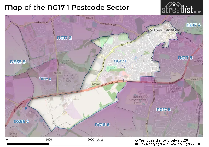
The NG17 1 Postcode shares a border with NG17 4 (SUTTON-IN-ASHFIELD), NG17 5 (SUTTON-IN-ASHFIELD, Maun Valley Industrial Park), NG17 8 (Kirkby-in-Ashfield), DE55 2 (South Normanton), NG16 6 (Selston, Pinxton) and NG17 2 (SUTTON-IN-ASHFIELD, Huthwaite).
The sector is within the post town of SUTTON-IN-ASHFIELD.
NG17 1 is a postcode sector within the NG17 postcode district which is within the NG Nottingham postcode area.
The Royal Mail delivery office for the NG17 1 postal sector is the Sutton-in-ashfield Delivery Office.
The area of the NG17 1 postcode sector is 1.29 square miles which is 3.35 square kilometres or 826.63 square acres.
Waterways within the NG17 1 postcode sector include the Blackwell Brook.

Map of the NG17 1 Postcode Sector
Explore the NG17 1 postcode sector by using our free interactive map.
| N | G | 1 | 7 | - | 1 | X | X |
| N | G | 1 | 7 | Space | 1 | Letter | Letter |
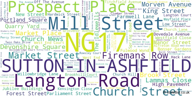
Official List of Streets
SUTTON-IN-ASHFIELD (126 Streets)
Unofficial Streets or Alternative Spellings
SUTTON-IN-ASHFIELD
CHURCH AVENUE CORENE AVENUE COWPASTURE LANE CRASTER STREET CURSHAM STREET DOUGLAS ROAD HARDWICK LANE LAMMAS ROAD LEAMINGTON DRIVE OUTRAM STREET PEVERIL DRIVE REFORM STREET SILK STREET STATION ROAD STUART STREET TUDOR STREET WINDMILL CLOSE COALFIELDS CLOSE FOX STREET HIGH STREET KINGS MILL ROAD EAST STATION STREET VICTORIA STREET WOODS HILLSouth Normanton
FARMWELL LANEPinxton
BROOKHILL LANEWeather Forecast for NG17 1
Press Button to Show Forecast for Kirkby In Ashfield
| Time Period | Icon | Description | Temperature | Rain Probability | Wind |
|---|---|---|---|---|---|
| 15:00 to 18:00 | Cloudy | 22.0°C (feels like 20.0°C) | 28.00% | SE 9 mph | |
| 18:00 to 21:00 | Cloudy | 21.0°C (feels like 19.0°C) | 33.00% | SE 9 mph | |
| 21:00 to 00:00 | Partly cloudy (night) | 17.0°C (feels like 16.0°C) | 11.00% | SE 4 mph |
Press Button to Show Forecast for Kirkby In Ashfield
| Time Period | Icon | Description | Temperature | Rain Probability | Wind |
|---|---|---|---|---|---|
| 00:00 to 03:00 | Clear night | 15.0°C (feels like 14.0°C) | 1.00% | SE 4 mph | |
| 03:00 to 06:00 | Clear night | 13.0°C (feels like 12.0°C) | 2.00% | SE 4 mph | |
| 06:00 to 09:00 | Cloudy | 14.0°C (feels like 13.0°C) | 5.00% | S 7 mph | |
| 09:00 to 12:00 | Cloudy | 16.0°C (feels like 14.0°C) | 4.00% | S 11 mph | |
| 12:00 to 15:00 | Partly cloudy (day) | 19.0°C (feels like 16.0°C) | 1.00% | S 13 mph | |
| 15:00 to 18:00 | Cloudy | 20.0°C (feels like 17.0°C) | 6.00% | S 13 mph | |
| 18:00 to 21:00 | Cloudy | 18.0°C (feels like 15.0°C) | 10.00% | SSE 11 mph | |
| 21:00 to 00:00 | Cloudy | 16.0°C (feels like 14.0°C) | 10.00% | SSE 9 mph |
Press Button to Show Forecast for Kirkby In Ashfield
| Time Period | Icon | Description | Temperature | Rain Probability | Wind |
|---|---|---|---|---|---|
| 00:00 to 03:00 | Cloudy | 14.0°C (feels like 12.0°C) | 19.00% | SE 9 mph | |
| 03:00 to 06:00 | Light rain | 13.0°C (feels like 11.0°C) | 50.00% | ESE 9 mph | |
| 06:00 to 09:00 | Light rain | 13.0°C (feels like 11.0°C) | 57.00% | ESE 9 mph | |
| 09:00 to 12:00 | Heavy rain | 14.0°C (feels like 13.0°C) | 79.00% | ESE 9 mph | |
| 12:00 to 15:00 | Heavy rain | 16.0°C (feels like 14.0°C) | 79.00% | ESE 11 mph | |
| 15:00 to 18:00 | Heavy rain shower (day) | 16.0°C (feels like 14.0°C) | 62.00% | SSE 11 mph | |
| 18:00 to 21:00 | Light rain shower (day) | 15.0°C (feels like 14.0°C) | 45.00% | SSE 9 mph | |
| 21:00 to 00:00 | Cloudy | 13.0°C (feels like 12.0°C) | 20.00% | SE 7 mph |
Press Button to Show Forecast for Kirkby In Ashfield
| Time Period | Icon | Description | Temperature | Rain Probability | Wind |
|---|---|---|---|---|---|
| 00:00 to 03:00 | Cloudy | 12.0°C (feels like 11.0°C) | 10.00% | SE 7 mph | |
| 03:00 to 06:00 | Cloudy | 11.0°C (feels like 10.0°C) | 6.00% | ESE 4 mph | |
| 06:00 to 09:00 | Cloudy | 12.0°C (feels like 11.0°C) | 10.00% | E 7 mph | |
| 09:00 to 12:00 | Cloudy | 14.0°C (feels like 13.0°C) | 15.00% | ESE 7 mph | |
| 12:00 to 15:00 | Light rain shower (day) | 17.0°C (feels like 15.0°C) | 37.00% | ESE 9 mph | |
| 15:00 to 18:00 | Light rain shower (day) | 17.0°C (feels like 16.0°C) | 37.00% | SE 9 mph | |
| 18:00 to 21:00 | Light rain shower (day) | 17.0°C (feels like 15.0°C) | 33.00% | SE 7 mph | |
| 21:00 to 00:00 | Clear night | 13.0°C (feels like 13.0°C) | 5.00% | ESE 4 mph |
Press Button to Show Forecast for Kirkby In Ashfield
| Time Period | Icon | Description | Temperature | Rain Probability | Wind |
|---|---|---|---|---|---|
| 00:00 to 03:00 | Clear night | 12.0°C (feels like 11.0°C) | 2.00% | ESE 4 mph | |
| 03:00 to 06:00 | Mist | 11.0°C (feels like 10.0°C) | 14.00% | SE 4 mph | |
| 06:00 to 09:00 | Mist | 12.0°C (feels like 11.0°C) | 13.00% | SSW 4 mph | |
| 09:00 to 12:00 | Partly cloudy (day) | 15.0°C (feels like 15.0°C) | 4.00% | S 4 mph | |
| 12:00 to 15:00 | Cloudy | 18.0°C (feels like 17.0°C) | 12.00% | SE 4 mph | |
| 15:00 to 18:00 | Light rain shower (day) | 18.0°C (feels like 18.0°C) | 30.00% | SSW 7 mph | |
| 18:00 to 21:00 | Light rain shower (day) | 18.0°C (feels like 17.0°C) | 31.00% | SSE 7 mph | |
| 21:00 to 00:00 | Partly cloudy (night) | 15.0°C (feels like 14.0°C) | 6.00% | NNW 7 mph |
Schools and Places of Education Within the NG17 1 Postcode Sector
Sutton Community Academy
Academy sponsor led
High Pavement, Sutton-in-Ashfield, Nottinghamshire, NG17 1EE
Head: Mr Lewis Taylor
Ofsted Rating: Good
Inspection: 2022-04-27 (746 days ago)
Website: Visit Sutton Community Academy Website
Phone: 01623980055
Number of Pupils: 817
House Prices in the NG17 1 Postcode Sector
| Type of Property | 2018 Average | 2018 Sales | 2017 Average | 2017 Sales | 2016 Average | 2016 Sales | 2015 Average | 2015 Sales |
|---|---|---|---|---|---|---|---|---|
| Detached | £209,977 | 46 | £206,238 | 41 | £199,893 | 40 | £183,223 | 46 |
| Semi-Detached | £137,371 | 35 | £120,674 | 31 | £123,396 | 24 | £126,935 | 36 |
| Terraced | £87,350 | 20 | £93,110 | 35 | £92,765 | 27 | £94,885 | 20 |
| Flats | £51,225 | 2 | £43,713 | 4 | £0 | 0 | £74,950 | 1 |
Important Postcodes NG17 1 in the Postcode Sector
NG17 1AA is the postcode for Royal Mail, Sutton-in-Ashfield Delivery Office, Langton Road
NG17 1AE is the postcode for Nottinghamshire Police, Police Station, 45 Church Street
NG17 1AL is the postcode for Broadway House, Brook Street, and Broadway, 2 Brook Street
NG17 1AT is the postcode for Ashfield Medical Centre, 1 King Street
NG17 1BD is the postcode for Ashfield District Council, Fox Street
NG17 1BE is the postcode for Oats Hill Health Centre, Forest Street
NG17 1BP is the postcode for Ashfield Business Centre, 39, The Idlewells, Nottinghamshire County Council, Sutton-in-Ashfield Library, The Idlewells, SUTTON IN ASHFIELD LIBRARY, THE IDLEWELLS, SUTTON IN ASHFIELD, The Idlewells Indoor Market, and Sutton In Ashfield Library, The Idlewells
NG17 1DH is the postcode for Nags Head Inn, 37 Low Street
NG17 1EE is the postcode for MAIN SCHOOL BUILDING, Sutton Centre Youth Community & Play, Sutton Centre, High Pavement, Sutton Centre, Sutton Community Academy, Sutton Centre, BUILDING 90, Sutton Centre Youth Community & Play, Sutton Centre, High Pavement, Sutton Centre, BUILDING 96, Sutton Centre Youth Community & Play, Sutton Centre, High Pavement, Sutton Centre, and SUTTON COMMUNITY ACADEMY, SUTTON CENTRE, HIGH PAVEMENT
NG17 1ER is the postcode for Ashcroft, Langton Road
NG17 1ES is the postcode for Willowbrook Medical Practice, Brook Street
NG17 1HU is the postcode for CLASSROOM BLOCK, Mapplewells Junior & Infant School, Alfreton Road, Mapplewells Junior & Infant School, Alfreton Road, MAPPLEWELLS PRIMARY SCHOOL AND NURSERY, ALFRETON ROAD, SUTTON IN ASHFIELD, and Mapplewells Primary School And Nursery, Alfreton Road
NG17 1JU is the postcode for Whitemeadow Furniture, Unit B, and Whitemeadow Furniture, Orchard Way
NG17 1JW is the postcode for Woodlands Medical Practice, Bluebell Wood Way
| The NG17 1 Sector is within these Local Authorities |
|
|---|---|
| The NG17 1 Sector is within these Counties |
|
| The NG17 1 Sector is within these Water Company Areas |
|