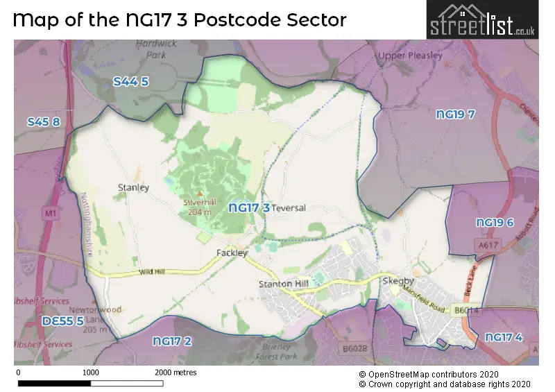
The NG17 3 postcode sector stands on the Derbyshire and Nottinghamshire border.
Did you know? According to the 2021 Census, the NG17 3 postcode sector is home to a bustling 8,801 residents!
Given that each sector allows for 400 unique postcode combinations. Letters C, I, K, M, O and V are not allowed in the last two letters of a postcode. With 179 postcodes already in use, this leaves 221 units available.
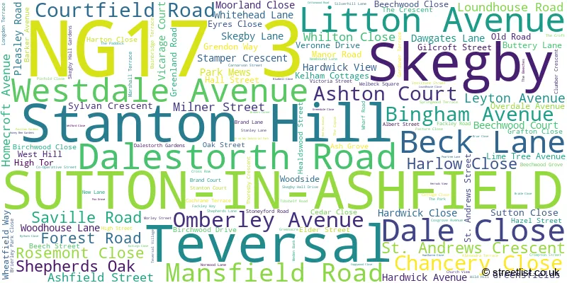
The largest settlement in the NG17 3 postal code is SUTTON-IN-ASHFIELD followed by Stanton Hill, and Skegby.
The NG17 3 Postcode shares a border with NG17 4 (SUTTON-IN-ASHFIELD), NG19 6 (MANSFIELD), S44 5 (Calow, Duckmanton, Glapwell), S45 8 (Pilsley, Lower Pilsley), DE55 5 (Tibshelf, Newton, Blackwell), NG17 2 (SUTTON-IN-ASHFIELD, Huthwaite) and NG19 7 (MANSFIELD, Pleasley, Mansfield Woodhouse).
The sector is within the post town of SUTTON-IN-ASHFIELD.
NG17 3 is a postcode sector within the NG17 postcode district which is within the NG Nottingham postcode area.
The Royal Mail delivery office for the NG17 3 postal sector is the Sutton-in-ashfield Delivery Office.
The area of the NG17 3 postcode sector is 6.01 square miles which is 15.56 square kilometres or 3,845.49 square acres.
The NG17 3 postcode sector is crossed by the M1 motorway.
Waterways within the NG17 3 postcode sector include the River Meden.

Map of the NG17 3 Postcode Sector
Explore the NG17 3 postcode sector by using our free interactive map.
| N | G | 1 | 7 | - | 3 | X | X |
| N | G | 1 | 7 | Space | 3 | Letter | Letter |
Official List of Streets
Stanton Hill (36 Streets)
SUTTON-IN-ASHFIELD (79 Streets)
Teversal (9 Streets)
Skegby (14 Streets)
Unofficial Streets or Alternative Spellings
MANSFIELD
ABBOTT ROAD PENNIMENT LANESUTTON-IN-ASHFIELD
DALESTORTH CLOSE DALESTORTH STREET KINGS MILL ROAD EAST LINDHOLME WAY PRIOR CLOSE BRIERLEY BRANCH GRANGE CLOSE GREENFIELDS HILL TOP FARM LADY SPENCERS WALK LEGION DRIVE LINK TRACK LOUND HOUSE CLOSE LOUND HOUSE ROAD LOW ROAD MANOR CLOSE MANSFIELD LANE NEWTONWOOD LANE ROOLEY LANE SELBORNE COTTAGES SHERWOOD WAY WEST SILVERHILL TRAIL SKEGBY TRAIL STATION YARD TEVERSAL TRAIL TOP LANE WHARF LANEMANSFIELD,
SKEGBY LANEStanton Hill
CO-OPERATIVE STREETHuthwaite
CHESTERFIELD ROADPleasley
DAWGATES LANETibshelf
MANSFIELD ROADWeather Forecast for NG17 3
Press Button to Show Forecast for Hardwick Hall Garden (Nt)
| Time Period | Icon | Description | Temperature | Rain Probability | Wind |
|---|---|---|---|---|---|
| 00:00 to 03:00 | Partly cloudy (night) | 4.0°C (feels like 2.0°C) | 1.00% | ENE 4 mph | |
| 03:00 to 06:00 | Cloudy | 3.0°C (feels like 1.0°C) | 5.00% | NNE 4 mph | |
| 06:00 to 09:00 | Cloudy | 4.0°C (feels like 1.0°C) | 6.00% | NNE 7 mph | |
| 09:00 to 12:00 | Cloudy | 7.0°C (feels like 5.0°C) | 19.00% | NE 9 mph | |
| 12:00 to 15:00 | Overcast | 9.0°C (feels like 6.0°C) | 23.00% | ENE 11 mph | |
| 15:00 to 18:00 | Overcast | 8.0°C (feels like 6.0°C) | 19.00% | ENE 11 mph | |
| 18:00 to 21:00 | Overcast | 8.0°C (feels like 5.0°C) | 14.00% | NE 11 mph | |
| 21:00 to 00:00 | Overcast | 6.0°C (feels like 3.0°C) | 11.00% | NE 9 mph |
Press Button to Show Forecast for Hardwick Hall Garden (Nt)
| Time Period | Icon | Description | Temperature | Rain Probability | Wind |
|---|---|---|---|---|---|
| 00:00 to 03:00 | Overcast | 6.0°C (feels like 2.0°C) | 13.00% | NNE 11 mph | |
| 03:00 to 06:00 | Light rain | 5.0°C (feels like 1.0°C) | 55.00% | N 13 mph | |
| 06:00 to 09:00 | Heavy rain | 5.0°C (feels like 1.0°C) | 82.00% | N 13 mph | |
| 09:00 to 12:00 | Heavy rain | 6.0°C (feels like 2.0°C) | 82.00% | NNW 13 mph | |
| 12:00 to 15:00 | Light rain | 7.0°C (feels like 4.0°C) | 47.00% | NW 11 mph | |
| 15:00 to 18:00 | Cloudy | 9.0°C (feels like 7.0°C) | 13.00% | WNW 9 mph | |
| 18:00 to 21:00 | Sunny day | 9.0°C (feels like 7.0°C) | 5.00% | W 9 mph | |
| 21:00 to 00:00 | Clear night | 6.0°C (feels like 4.0°C) | 3.00% | SW 7 mph |
Press Button to Show Forecast for Hardwick Hall Garden (Nt)
| Time Period | Icon | Description | Temperature | Rain Probability | Wind |
|---|---|---|---|---|---|
| 00:00 to 03:00 | Clear night | 5.0°C (feels like 2.0°C) | 1.00% | SW 7 mph | |
| 03:00 to 06:00 | Clear night | 4.0°C (feels like 1.0°C) | 0.00% | SSW 7 mph | |
| 06:00 to 09:00 | Sunny day | 5.0°C (feels like 2.0°C) | 1.00% | SSW 9 mph | |
| 09:00 to 12:00 | Partly cloudy (day) | 10.0°C (feels like 7.0°C) | 1.00% | S 11 mph | |
| 12:00 to 15:00 | Cloudy | 13.0°C (feels like 10.0°C) | 5.00% | S 13 mph | |
| 15:00 to 18:00 | Cloudy | 14.0°C (feels like 11.0°C) | 7.00% | S 13 mph | |
| 18:00 to 21:00 | Partly cloudy (day) | 13.0°C (feels like 10.0°C) | 3.00% | S 11 mph | |
| 21:00 to 00:00 | Clear night | 9.0°C (feels like 7.0°C) | 2.00% | SSE 9 mph |
Press Button to Show Forecast for Hardwick Hall Garden (Nt)
| Time Period | Icon | Description | Temperature | Rain Probability | Wind |
|---|---|---|---|---|---|
| 00:00 to 03:00 | Clear night | 8.0°C (feels like 5.0°C) | 2.00% | SSE 9 mph | |
| 03:00 to 06:00 | Clear night | 6.0°C (feels like 4.0°C) | 3.00% | SE 7 mph | |
| 06:00 to 09:00 | Sunny day | 7.0°C (feels like 5.0°C) | 3.00% | ESE 7 mph | |
| 09:00 to 12:00 | Cloudy | 11.0°C (feels like 9.0°C) | 8.00% | ESE 9 mph | |
| 12:00 to 15:00 | Partly cloudy (day) | 15.0°C (feels like 12.0°C) | 5.00% | ESE 11 mph | |
| 15:00 to 18:00 | Partly cloudy (day) | 15.0°C (feels like 13.0°C) | 7.00% | ESE 11 mph | |
| 18:00 to 21:00 | Partly cloudy (day) | 14.0°C (feels like 12.0°C) | 7.00% | ESE 9 mph | |
| 21:00 to 00:00 | Cloudy | 11.0°C (feels like 10.0°C) | 9.00% | E 7 mph |
Schools and Places of Education Within the NG17 3 Postcode Sector
Healdswood Infants' and Nursery School
Community school
Barker Avenue, Sutton-in-Ashfield, Nottinghamshire, NG17 3FQ
Head: Mrs Jayne Renshaw
Ofsted Rating: Good
Inspection: 2021-11-17 (892 days ago)
Website: Visit Healdswood Infants' and Nursery School Website
Phone: 01623462449
Number of Pupils: 218
Skegby Junior Academy
Academy sponsor led
Ash Grove, Sutton-in-Ashfield, Nottinghamshire, NG17 3FH
Head: Mrs Pauline Marples
Ofsted Rating: Good
Inspection: 2019-01-30 (1914 days ago)
Website: Visit Skegby Junior Academy Website
Phone: 01623460329
Number of Pupils: 155
St Andrew's CofE Primary and Nursery School
Voluntary controlled school
Mansfield Road, Sutton-in-Ashfield, Nottinghamshire, NG17 3DW
Head: Mr Ian Snelling
Ofsted Rating: Good
Inspection: 2023-07-20 (282 days ago)
Website: Visit St Andrew's CofE Primary and Nursery School Website
Phone: 01623484522
Number of Pupils: 361
House Prices in the NG17 3 Postcode Sector
| Type of Property | 2018 Average | 2018 Sales | 2017 Average | 2017 Sales | 2016 Average | 2016 Sales | 2015 Average | 2015 Sales |
|---|---|---|---|---|---|---|---|---|
| Detached | £209,386 | 59 | £223,445 | 52 | £209,582 | 61 | £175,357 | 54 |
| Semi-Detached | £125,870 | 47 | £110,665 | 39 | £112,915 | 50 | £100,917 | 52 |
| Terraced | £86,070 | 40 | £80,249 | 38 | £77,413 | 36 | £69,326 | 33 |
| Flats | £0 | 0 | £38,250 | 2 | £0 | 0 | £0 | 0 |
Important Postcodes NG17 3 in the Postcode Sector
NG17 3DW is the postcode for KEY STAGE 1, St. Andrews C of E Primary School, Mansfield Road, KEY STAGE 2, St. Andrews C of E Primary School, Mansfield Road, and RECEPTION, St. Andrews C of E Primary School, Mansfield Road
NG17 3EE is the postcode for Skegby Family Medical Centre, Mansfield Road
NG17 3FH is the postcode for Skegby Junior Academy, Ash Grove, and SKEGBY JUNIOR ACADEMY, ASH GROVE, SKEGBY
NG17 3FQ is the postcode for Healdswood Infant School, Barker Avenue, Skegby, and Healdswood Infant School, Barker Avenue
| The NG17 3 Sector is within these Local Authorities |
|
|---|---|
| The NG17 3 Sector is within these Counties |
|
| The NG17 3 Sector is within these Water Company Areas |
|
Tourist Attractions within the NG17 3 Postcode Area
We found 1 visitor attractions within the NG17 postcode area
| Teversal Trails Visitors Centre |
|---|
| Visitor Centres |
| Heritage / Visitor Centre |
| View Teversal Trails Visitors Centre on Google Maps |