The NG33 postcode district is a postal district located in the NG Nottingham postcode area with a population of 9,741 residents according to the 2021 England and Wales Census.
The area of the NG33 postcode district is 100.68 square miles which is 260.76 square kilometres or 64,434.48 acres.
Currently, the NG33 district has about 458 postcode units spread across 2 geographic postcode sectors.
Given that each sector allows for 400 unique postcode combinations, the district has a capacity of 800 postcodes. With 458 postcodes already in use, this leaves 342 units available.
The largest settlement in the NG33 postal code is Colsterworth followed by South Witham, and Corby Glen.
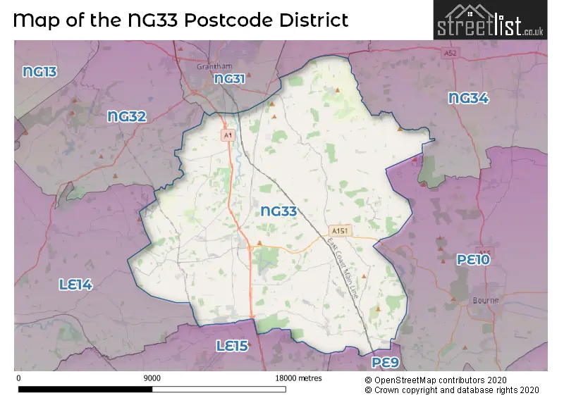
The NG33 Postcode shares a border with LE15 (OAKHAM, Uppingham, Barleythorpe), PE9 (STAMFORD, Ketton, Tallington), PE10 (BOURNE, Morton, Thurlby), NG34 (SLEAFORD, Ruskington, Heckington), NG32 (Barrowby, Ancaster, Caythorpe) and NG31 (GRANTHAM, Gonerby Hill Foot, Great Gonerby).
The primary settlement in the NG33 postcode district is Castle Bytham in Lincolnshire, England. Other significant settlements in the district include Corby Glen, Ingoldsby, Little Bytham, Colsterworth, Great Ponton, South Witham, and Stoke Rochford. The main post town for the district is Grantham.
For the district NG33, we have data on 2 postcode sectors. Here's a breakdown: The sector NG33 4, covers Corby Glen and Castle Bytham and Ropsley in Lincolnshire. The sector NG33 5, covers Colsterworth and South Witham and Great Ponton in Lincolnshire.

Map of the NG33 Postcode District
Explore the NG33 postcode district by using our free interactive map.
When it comes to local government, postal geography often disregards political borders. However, for a breakdown in the NG33 District: the district mostly encompasses the South Kesteven District (442 postcodes), and finally, the Melton District (B) area (22 postcodes).
Recent House Sales in NG33
| Date | Price | Address |
|---|---|---|
| 28/09/2023 | £380,000 | Water Lane, Woolsthorpe By Colsterworth, Grantham, NG33 5PD |
| 07/09/2023 | £355,000 | Barn Owl Close, Corby Glen, Grantham, NG33 4TB |
| 17/08/2023 | £195,000 | Barleycroft Road, Corby Glen, Grantham, NG33 4LT |
| 16/08/2023 | £250,000 | Woolsthorpe Road, Woolsthorpe By Colsterworth, Grantham, NG33 5NT |
| 09/08/2023 | £130,000 | Willoughby Close, Corby Glen, Grantham, NG33 4NQ |
| 09/08/2023 | £460,000 | St Johns Drive, Corby Glen, Grantham, NG33 4NG |
| 08/08/2023 | £285,000 | Church Street, Corby Glen, Grantham, NG33 4NJ |
| 08/08/2023 | £417,000 | Walsingham Drive, Corby Glen, Grantham, NG33 4TA |
| 08/08/2023 | £325,000 | School Lane, Old Somerby, Grantham, NG33 4AG |
| 08/08/2023 | £700,000 | Corby Road, Swayfield, Grantham, NG33 4LQ |
Weather Forecast for NG33
Press Button to Show Forecast for Burton Coggles
| Time Period | Icon | Description | Temperature | Rain Probability | Wind |
|---|---|---|---|---|---|
| 06:00 to 09:00 | Cloudy | 5.0°C (feels like 3.0°C) | 9.00% | NE 7 mph | |
| 09:00 to 12:00 | Overcast | 8.0°C (feels like 5.0°C) | 15.00% | ENE 11 mph | |
| 12:00 to 15:00 | Overcast | 9.0°C (feels like 6.0°C) | 23.00% | ENE 11 mph | |
| 15:00 to 18:00 | Overcast | 8.0°C (feels like 5.0°C) | 16.00% | NE 11 mph | |
| 18:00 to 21:00 | Overcast | 7.0°C (feels like 4.0°C) | 16.00% | NE 11 mph | |
| 21:00 to 00:00 | Overcast | 6.0°C (feels like 3.0°C) | 13.00% | NE 11 mph |
Press Button to Show Forecast for Burton Coggles
| Time Period | Icon | Description | Temperature | Rain Probability | Wind |
|---|---|---|---|---|---|
| 00:00 to 03:00 | Drizzle | 6.0°C (feels like 3.0°C) | 41.00% | NNE 11 mph | |
| 03:00 to 06:00 | Heavy rain | 6.0°C (feels like 3.0°C) | 87.00% | NNE 13 mph | |
| 06:00 to 09:00 | Heavy rain | 6.0°C (feels like 3.0°C) | 92.00% | N 13 mph | |
| 09:00 to 12:00 | Heavy rain | 7.0°C (feels like 3.0°C) | 82.00% | NNW 13 mph | |
| 12:00 to 15:00 | Light rain | 8.0°C (feels like 4.0°C) | 60.00% | NW 13 mph | |
| 15:00 to 18:00 | Light rain | 9.0°C (feels like 6.0°C) | 46.00% | WNW 11 mph | |
| 18:00 to 21:00 | Partly cloudy (day) | 9.0°C (feels like 7.0°C) | 6.00% | WSW 7 mph | |
| 21:00 to 00:00 | Partly cloudy (night) | 6.0°C (feels like 4.0°C) | 3.00% | SW 7 mph |
Press Button to Show Forecast for Burton Coggles
| Time Period | Icon | Description | Temperature | Rain Probability | Wind |
|---|---|---|---|---|---|
| 00:00 to 03:00 | Clear night | 5.0°C (feels like 2.0°C) | 2.00% | SW 7 mph | |
| 03:00 to 06:00 | Clear night | 4.0°C (feels like 1.0°C) | 1.00% | SW 7 mph | |
| 06:00 to 09:00 | Sunny day | 5.0°C (feels like 2.0°C) | 1.00% | SSW 7 mph | |
| 09:00 to 12:00 | Sunny day | 11.0°C (feels like 9.0°C) | 1.00% | S 11 mph | |
| 12:00 to 15:00 | Cloudy | 13.0°C (feels like 11.0°C) | 6.00% | S 13 mph | |
| 15:00 to 18:00 | Cloudy | 14.0°C (feels like 11.0°C) | 4.00% | S 11 mph | |
| 18:00 to 21:00 | Partly cloudy (day) | 13.0°C (feels like 11.0°C) | 1.00% | S 9 mph | |
| 21:00 to 00:00 | Clear night | 9.0°C (feels like 7.0°C) | 1.00% | SSE 9 mph |
Press Button to Show Forecast for Burton Coggles
| Time Period | Icon | Description | Temperature | Rain Probability | Wind |
|---|---|---|---|---|---|
| 00:00 to 03:00 | Clear night | 7.0°C (feels like 4.0°C) | 1.00% | SE 7 mph | |
| 03:00 to 06:00 | Mist | 6.0°C (feels like 4.0°C) | 16.00% | SE 7 mph | |
| 06:00 to 09:00 | Mist | 7.0°C (feels like 5.0°C) | 17.00% | ESE 7 mph | |
| 09:00 to 12:00 | Partly cloudy (day) | 12.0°C (feels like 10.0°C) | 4.00% | ESE 9 mph | |
| 12:00 to 15:00 | Partly cloudy (day) | 15.0°C (feels like 13.0°C) | 7.00% | ESE 11 mph | |
| 15:00 to 18:00 | Cloudy | 15.0°C (feels like 13.0°C) | 11.00% | ESE 9 mph | |
| 18:00 to 21:00 | Cloudy | 14.0°C (feels like 12.0°C) | 12.00% | ESE 9 mph | |
| 21:00 to 00:00 | Cloudy | 11.0°C (feels like 9.0°C) | 9.00% | E 7 mph |
Where is the NG33 Postcode District?
The postcode district NG33 is located in Grantham. It is a town situated in Lincolnshire, England. Grantham is surrounded by several nearby towns, including Bourne to the East, Stamford to the South, Oakham to the South West, Melton Mowbray to the West, Sleaford to the North East, Newark to the North West, and Peterborough to the South East. The distance from Grantham to London, the center of the capital city, is approximately 92.82 miles.
The district is within the post town of GRANTHAM.
The sector has postcodes within the nation of England.
The NG33 Postcode District is covers the following regions.
- Lincolnshire - Lincolnshire - East Midlands (England)
- Leicestershire CC and Rutland - Leicestershire, Rutland and Northamptonshire - East Midlands (England)
| Postcode Sector | Delivery Office |
|---|---|
| NG33 4 | Grantham Delivery Office |
| NG33 5 | Grantham Delivery Office |
| N | G | 3 | 3 | - | X | X | X |
| N | G | 3 | 3 | Space | Numeric | Letter | Letter |
Tourist Attractions within the Postcode Area
We found 2 visitor attractions within the NG33 postcode area
| Woolsthorpe Manor |
|---|
| Historic Properties |
| Historic House / House and Garden / Palace |
| View Woolsthorpe Manor on Google Maps |
| Easton Walled Gardens |
| Gardens |
| Garden |
| View Easton Walled Gardens on Google Maps |
Current Monthly Rental Prices
| # Bedrooms | Min Price | Max Price | Avg Price |
|---|---|---|---|
| 2 | £750 | £750 | £750 |
| 3 | £900 | £900 | £900 |
| 4 | £1,650 | £2,500 | £2,075 |
| 5 | £2,500 | £2,500 | £2,500 |
Current House Prices
| # Bedrooms | Min Price | Max Price | Avg Price |
|---|---|---|---|
| £125,000 | £1,550,000 | £441,000 | |
| 2 | £55,000 | £340,000 | £202,326 |
| 3 | £85,750 | £595,000 | £304,840 |
| 4 | £247,750 | £1,250,000 | £495,040 |
| 5 | £435,000 | £900,000 | £558,666 |
| 6 | £465,000 | £465,000 | £465,000 |
| 7 | £1,800,000 | £1,800,000 | £1,800,000 |
Estate Agents who Operate in the NG33 District
| Logo | Name | Brand Name | Address | Contact Number | Total Properties |
|---|---|---|---|---|---|
 | Oakham | Moores Property Hub | Goodwood House, Hackamore Way, Oakham, LE15 7FS | 01572 757979 | 13 |
 | Bourne | Newton Fallowell | 2 North Street, Bourne, PE10 9EA | 01778 301165 | 10 |
 | Grantham | William H. Brown | 63 High Street Grantham NG31 6NN | 01476 851458 | 8 |
 | Lincoln | haart | 37 Silver Street, Lincoln, LN2 1EH | 01522 303904 | 6 |
 | Stamford | King West | St. Marys Street, Stamford, PE9 2DE | 01780 431650 | 5 |
- Birkholme
- Bitchfield
- Boothby Pagnell
- Buckminster
- Burton-le-Coggles
- Careby
- Castle Bytham
- Colsterworth
- Corby Glen
- Counthorpe
- Creeton
- Easton
- Grantham
- Great Humby
- Great Ponton
- Gunby
- Harlaxton
- Humby
- Hungerton
- Ingoldsby
- Irnham
- Lenton
- Little Bytham
- Little Ponton
- North Witham
- Old Somerby
- Ropsley
- Sewstern
- Skillington
- South Witham
- Sproxton
- Stainby
- Stoke Rochford
- Swayfield
- Swinstead
- Woodnook
- Woolsthorpe-by-Colsterworth
| Type of Property | 2018 Average | 2018 Sales | 2017 Average | 2017 Sales | 2016 Average | 2016 Sales | 2015 Average | 2015 Sales |
|---|---|---|---|---|---|---|---|---|
| Detached | £337,177 | 80 | £302,287 | 97 | £322,618 | 118 | £287,569 | 91 |
| Semi-Detached | £191,882 | 28 | £156,524 | 35 | £171,917 | 51 | £151,983 | 45 |
| Terraced | £154,200 | 32 | £120,711 | 33 | £123,005 | 38 | £112,289 | 38 |
| Flats | £0 | 0 | £0 | 0 | £0 | 0 | £0 | 0 |