The NN8 1 postcode sector is within the county of Northamptonshire.
Did you know? According to the 2021 Census, the NN8 1 postcode sector is home to a bustling 10,312 residents!
Given that each sector allows for 400 unique postcode combinations. Letters C, I, K, M, O and V are not allowed in the last two letters of a postcode. With 221 postcodes already in use, this leaves 179 units available.
The NN8 1 postal code covers the settlement of WELLINGBOROUGH.
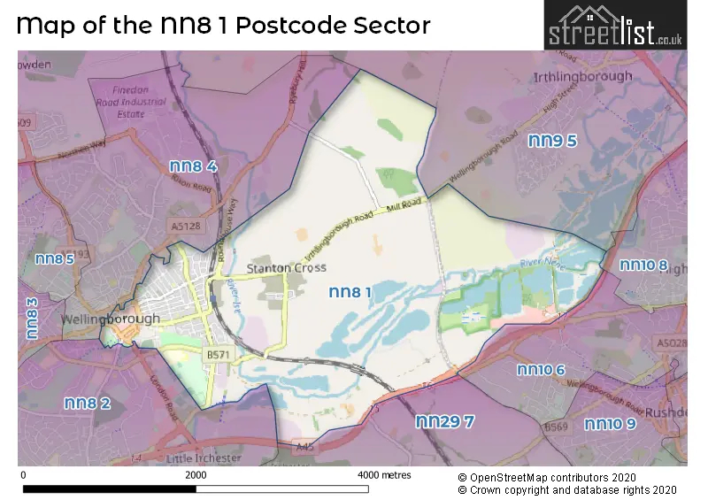
The NN8 1 Postcode shares a border with NN8 4 (WELLINGBOROUGH, Finedon Road Industrial Estate), NN10 6 (RUSHDEN), NN10 8 (Higham Ferrers), NN8 2 (WELLINGBOROUGH, Wilby, Little Irchester), NN9 5 (Irthlingborough, Finedon, WELLINGBOROUGH) and NN29 7 (Irchester, Wollaston, Bozeat).
The sector is within the post town of WELLINGBOROUGH.
NN8 1 is a postcode sector within the NN8 postcode district which is within the NN Northampton postcode area.
The Royal Mail delivery office for the NN8 1 postal sector is the Wellingborough Delivery Office.
The area of the NN8 1 postcode sector is 4.60 square miles which is 11.93 square kilometres or 2,947.19 square acres.
The NN8 1 postcode sector is crossed by the A45 Major A road.
Waterways within the NN8 1 postcode sector include the River Nene.

Map of the NN8 1 Postcode Sector
Explore the NN8 1 postcode sector by using our free interactive map.
| N | N | 8 | - | 1 | X | X |
| N | N | 8 | Space | 1 | Letter | Letter |
Official List of Streets
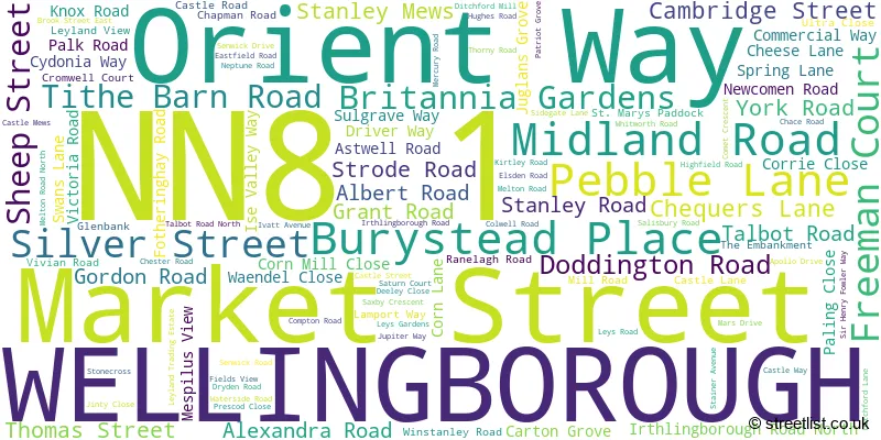
WELLINGBOROUGH (115 Streets)
Unofficial Streets or Alternative Spellings
Irthlingborough
WELLINGBOROUGH ROADWELLINGBOROUGH
ADAMS CLOSE CANNON STREET CHEESE LANE CHURCH STREET CLAUDIUS WAY CORN LANE DODDINGTON ROAD OXFORD STREET PARK ROAD SPRING LANE SWANS LANEIrchester
HIGHAM ROADDenington Industrial Estate
LONDON ROADWeather Forecast for NN8 1
Press Button to Show Forecast for Wellingborough
| Time Period | Icon | Description | Temperature | Rain Probability | Wind |
|---|---|---|---|---|---|
| 09:00 to 12:00 | Overcast | 7.0°C (feels like 5.0°C) | 15.00% | ENE 11 mph | |
| 12:00 to 15:00 | Overcast | 9.0°C (feels like 6.0°C) | 15.00% | ENE 11 mph | |
| 15:00 to 18:00 | Overcast | 9.0°C (feels like 6.0°C) | 14.00% | NE 11 mph | |
| 18:00 to 21:00 | Overcast | 8.0°C (feels like 5.0°C) | 12.00% | NE 11 mph | |
| 21:00 to 00:00 | Overcast | 7.0°C (feels like 4.0°C) | 50.00% | NNE 11 mph |
Press Button to Show Forecast for Wellingborough
| Time Period | Icon | Description | Temperature | Rain Probability | Wind |
|---|---|---|---|---|---|
| 00:00 to 03:00 | Light rain | 7.0°C (feels like 3.0°C) | 61.00% | NNE 13 mph | |
| 03:00 to 06:00 | Heavy rain | 7.0°C (feels like 3.0°C) | 90.00% | NNE 13 mph | |
| 06:00 to 09:00 | Heavy rain | 7.0°C (feels like 3.0°C) | 93.00% | N 13 mph | |
| 09:00 to 12:00 | Heavy rain | 7.0°C (feels like 4.0°C) | 81.00% | NNW 11 mph | |
| 12:00 to 15:00 | Light rain | 8.0°C (feels like 5.0°C) | 54.00% | WNW 13 mph | |
| 15:00 to 18:00 | Cloudy | 9.0°C (feels like 7.0°C) | 16.00% | W 9 mph | |
| 18:00 to 21:00 | Cloudy | 10.0°C (feels like 8.0°C) | 9.00% | WSW 7 mph | |
| 21:00 to 00:00 | Clear night | 7.0°C (feels like 5.0°C) | 2.00% | SW 7 mph |
Press Button to Show Forecast for Wellingborough
| Time Period | Icon | Description | Temperature | Rain Probability | Wind |
|---|---|---|---|---|---|
| 00:00 to 03:00 | Clear night | 6.0°C (feels like 4.0°C) | 1.00% | SW 7 mph | |
| 03:00 to 06:00 | Clear night | 4.0°C (feels like 2.0°C) | 1.00% | SSW 7 mph | |
| 06:00 to 09:00 | Sunny day | 5.0°C (feels like 3.0°C) | 1.00% | S 7 mph | |
| 09:00 to 12:00 | Partly cloudy (day) | 11.0°C (feels like 9.0°C) | 1.00% | S 11 mph | |
| 12:00 to 15:00 | Partly cloudy (day) | 13.0°C (feels like 11.0°C) | 3.00% | S 13 mph | |
| 15:00 to 18:00 | Partly cloudy (day) | 14.0°C (feels like 12.0°C) | 2.00% | S 13 mph | |
| 18:00 to 21:00 | Sunny day | 13.0°C (feels like 11.0°C) | 1.00% | S 9 mph | |
| 21:00 to 00:00 | Clear night | 9.0°C (feels like 7.0°C) | 1.00% | SSE 7 mph |
Press Button to Show Forecast for Wellingborough
| Time Period | Icon | Description | Temperature | Rain Probability | Wind |
|---|---|---|---|---|---|
| 00:00 to 03:00 | Clear night | 7.0°C (feels like 5.0°C) | 2.00% | SE 7 mph | |
| 03:00 to 06:00 | Clear night | 7.0°C (feels like 5.0°C) | 3.00% | ESE 7 mph | |
| 06:00 to 09:00 | Sunny day | 8.0°C (feels like 6.0°C) | 3.00% | ESE 7 mph | |
| 09:00 to 12:00 | Partly cloudy (day) | 13.0°C (feels like 11.0°C) | 3.00% | ESE 9 mph | |
| 12:00 to 15:00 | Cloudy | 16.0°C (feels like 13.0°C) | 8.00% | SE 11 mph | |
| 15:00 to 18:00 | Cloudy | 16.0°C (feels like 14.0°C) | 10.00% | SE 11 mph | |
| 18:00 to 21:00 | Cloudy | 15.0°C (feels like 13.0°C) | 11.00% | ESE 9 mph | |
| 21:00 to 00:00 | Cloudy | 12.0°C (feels like 10.0°C) | 9.00% | ESE 7 mph |
Schools and Places of Education Within the NN8 1 Postcode Sector
All Saints CEVA Primary School and Nursery
Voluntary aided school
Castle Street, Wellingborough, Northamptonshire, NN8 1LS
Head: Mrs Emma Johnson
Ofsted Rating: Good
Inspection: 2022-06-29 (668 days ago)
Website: Visit All Saints CEVA Primary School and Nursery Website
Phone: 01933225888
Number of Pupils: 228
Refocus
Other independent school
6 Knox Road, , , NN8 1HW
Head: Mrs Paula Tucker
Ofsted Rating: Good
Inspection: 2022-10-06 (569 days ago)
Website: Visit Refocus Website
Phone: 01933391660
Number of Pupils: 14
House Prices in the NN8 1 Postcode Sector
| Type of Property | 2018 Average | 2018 Sales | 2017 Average | 2017 Sales | 2016 Average | 2016 Sales | 2015 Average | 2015 Sales |
|---|---|---|---|---|---|---|---|---|
| Detached | £311,316 | 36 | £270,597 | 20 | £223,228 | 13 | £216,774 | 27 |
| Semi-Detached | £203,467 | 56 | £188,109 | 40 | £182,752 | 68 | £155,426 | 35 |
| Terraced | £170,860 | 121 | £150,830 | 102 | £149,674 | 144 | £132,860 | 124 |
| Flats | £117,052 | 21 | £105,574 | 34 | £118,156 | 68 | £94,231 | 38 |
Important Postcodes NN8 1 in the Postcode Sector
NN8 1AQ is the postcode for Royal Mail, Wellingborough Delivery Office, 212 Midland Road
NN8 1AS is the postcode for Wellingborough Library, Pebble Lane, and Wellingborough Library and Registrars Office, Pebble Lane, Wellingborough
NN8 1BN is the postcode for Borough Council of Wellingborough, Tithe Barn Road Offices
NN8 1BP is the postcode for Borough Council of Wellingborough, Swanspool House
NN8 1DZ is the postcode for Waendel Leisure Centre, Thomas Street, and Places for People Leisure Management Ltd, Waendel Leisure Centre, Thomas Street
NN8 1HF is the postcode for Magistrates Court, Midland Road, WELLINGBOROUGH POLICE STATION, Northamptonshire Police, Police Station, Midland Road, and Northamptonshire Police, Police Station, Midland Road
NN8 1LD is the postcode for H M Revenue & Customs, Christchurch House, The Embankment
NN8 1LP is the postcode for CASTLE BLOCK, Isebrook Hospital, Irthlingborough Road, ABBEY / VICTORIA BLOCK, Isebrook Hospital, Irthlingborough Road, NENE BLOCK, Isebrook Hospital, Irthlingborough Road, YORK BLOCK, Isebrook Hospital, Irthlingborough Road, BEECHWOOD HOUSE, Isebrook Hospital, Irthlingborough Road, BLOCKS 14, 17 & 18, Isebrook Hospital, Irthlingborough Road, Northamptonshire Teaching PCT, Isebrook Hospital, LANCASTER HOUSE, Isebrook Hospital, Irthlingborough Road, ABBEY BLOCK, Isebrook Hospital, Irthlingborough Road, and Isebrook Hospital, Irthlingborough Road
NN8 1LS is the postcode for All Saints CEVA Primary, Castle Street, and All Saints CEVA Primary School, Castle Street
NN8 1LT is the postcode for Ambulance Station, Irthlingborough Road, and Wellingborough Fire Station, Irthlingborough Road
NN8 1XA is the postcode for The Castle, Theatre & Arts Centre, 10 Castle Way
| The NN8 1 Sector is within these Local Authorities |
|
|---|---|
| The NN8 1 Sector is within these Counties |
|
| The NN8 1 Sector is within these Water Company Areas |
|
Tourist Attractions within the NN8 1 Postcode Area
We found 1 visitor attractions within the NN8 postcode area
| Wellingborough Museum |
|---|
| Museums & Art Galleries |
| Museum and / or Art Gallery |
| View Wellingborough Museum on Google Maps |