The NR13 5 postcode sector is within the county of Norfolk.
Did you know? According to the 2021 Census, the NR13 5 postcode sector is home to a bustling 8,363 residents!
Given that each sector allows for 400 unique postcode combinations. Letters C, I, K, M, O and V are not allowed in the last two letters of a postcode. With 226 postcodes already in use, this leaves 174 units available.
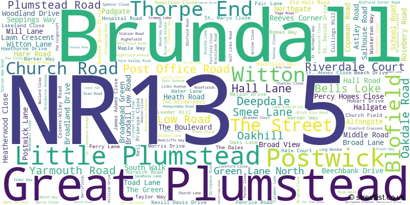
The largest settlement in the NR13 5 postal code is Brundall followed by Little Plumstead, and Thorpe End.
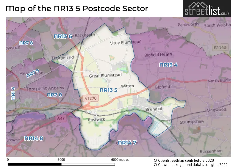
The NR13 5 Postcode shares a border with NR7 0 (NORWICH, Thorpe St. Andrew), NR13 4 (Blofield, Lingwood, Strumpshaw), NR13 6 (Rackheath, Salhouse, South Walsham), NR14 7 (Poringland, Framingham Earl, Surlingham) and NR14 8 (Mulbarton, Stoke Holy Cross, Trowse).
The sector is within the post town of NORWICH.
NR13 5 is a postcode sector within the NR1 postcode district which is within the NR Norwich postcode area.
The Royal Mail delivery office for the NR13 5 postal sector is the unknown.
The area of the NR13 5 postcode sector is 9.06 square miles which is 23.47 square kilometres or 5,799.96 square acres.
The NR13 5 postcode sector is crossed by the A47 Major A road.
Waterways within the NR13 5 postcode sector include the River Yare.

Map of the NR13 5 Postcode Sector
Explore the NR13 5 postcode sector by using our free interactive map.
| N | R | 1 | 3 | - | 5 | X | X |
| N | R | 1 | 3 | Space | 5 | Letter | Letter |
Official List of Streets
Thorpe End (20 Streets)
Little Plumstead (35 Streets)
Brundall (80 Streets)
Great Plumstead (13 Streets)
Postwick (20 Streets)
Unofficial Streets or Alternative Spellings
Strumpshaw
CUCKOO LANE LONG LANE BELT ROAD BRAYDESTON HALL LANE BRICK KILNS ROAD BROADLAND NORTHWAY BROADLAND WAY BURTT WAY CRANLEY ROAD GREEN LANE HALL ROAD NORTHERN DISTRIBUTOR ROAD NORWICH SOUTHERN BYPASS POPPY WAY POSTWICK ROAD RED ADMIRAL WAY REX 30 PLATINUM SAINT ANNES CLOSE SAINT CLEMENTS WAY SAINT DAVIDS DRIVE SAINT LAURENCE AVENUE SAINT MARYS CLOSE SAINT MICHAELS WAY THE GLEBE TURNER CERSCENTBrundall
LAUREL GROVEBlofield
BRUNDALL ROAD YARMOUTH ROADLittle Plumstead
COZENS-WILEY ROADNORWICH
PLUMSTEAD ROAD EASTWeather Forecast for NR13 5
Press Button to Show Forecast for Norfolk Ski Centre
| Time Period | Icon | Description | Temperature | Rain Probability | Wind |
|---|---|---|---|---|---|
| 21:00 to 00:00 | Heavy rain | 9.0°C (feels like 6.0°C) | 90.00% | NE 9 mph |
Press Button to Show Forecast for Norfolk Ski Centre
| Time Period | Icon | Description | Temperature | Rain Probability | Wind |
|---|---|---|---|---|---|
| 00:00 to 03:00 | Heavy rain | 9.0°C (feels like 6.0°C) | 94.00% | NE 11 mph | |
| 03:00 to 06:00 | Heavy rain | 10.0°C (feels like 8.0°C) | 86.00% | ESE 9 mph | |
| 06:00 to 09:00 | Light rain | 11.0°C (feels like 8.0°C) | 43.00% | SSE 11 mph | |
| 09:00 to 12:00 | Light rain | 11.0°C (feels like 9.0°C) | 53.00% | S 13 mph | |
| 12:00 to 15:00 | Heavy rain | 12.0°C (feels like 9.0°C) | 87.00% | SW 16 mph | |
| 15:00 to 18:00 | Light rain | 8.0°C (feels like 5.0°C) | 49.00% | WSW 16 mph | |
| 18:00 to 21:00 | Cloudy | 9.0°C (feels like 6.0°C) | 8.00% | SW 11 mph | |
| 21:00 to 00:00 | Cloudy | 8.0°C (feels like 6.0°C) | 4.00% | SSW 9 mph |
Press Button to Show Forecast for Norfolk Ski Centre
| Time Period | Icon | Description | Temperature | Rain Probability | Wind |
|---|---|---|---|---|---|
| 00:00 to 03:00 | Clear night | 7.0°C (feels like 4.0°C) | 0.00% | SSW 9 mph | |
| 03:00 to 06:00 | Clear night | 6.0°C (feels like 3.0°C) | 0.00% | SSW 7 mph | |
| 06:00 to 09:00 | Sunny day | 6.0°C (feels like 4.0°C) | 0.00% | SSW 7 mph | |
| 09:00 to 12:00 | Sunny day | 12.0°C (feels like 10.0°C) | 0.00% | SSW 11 mph | |
| 12:00 to 15:00 | Cloudy | 15.0°C (feels like 12.0°C) | 6.00% | S 13 mph | |
| 15:00 to 18:00 | Sunny day | 15.0°C (feels like 12.0°C) | 1.00% | S 13 mph | |
| 18:00 to 21:00 | Sunny day | 13.0°C (feels like 11.0°C) | 1.00% | SSE 11 mph | |
| 21:00 to 00:00 | Clear night | 9.0°C (feels like 7.0°C) | 0.00% | SSE 9 mph |
Press Button to Show Forecast for Norfolk Ski Centre
| Time Period | Icon | Description | Temperature | Rain Probability | Wind |
|---|---|---|---|---|---|
| 00:00 to 03:00 | Clear night | 8.0°C (feels like 7.0°C) | 1.00% | SE 7 mph | |
| 03:00 to 06:00 | Partly cloudy (night) | 8.0°C (feels like 6.0°C) | 2.00% | ESE 7 mph | |
| 06:00 to 09:00 | Partly cloudy (day) | 10.0°C (feels like 9.0°C) | 3.00% | ESE 7 mph | |
| 09:00 to 12:00 | Cloudy | 14.0°C (feels like 12.0°C) | 8.00% | SE 9 mph | |
| 12:00 to 15:00 | Cloudy | 16.0°C (feels like 14.0°C) | 9.00% | SE 9 mph | |
| 15:00 to 18:00 | Cloudy | 16.0°C (feels like 14.0°C) | 6.00% | SE 9 mph | |
| 18:00 to 21:00 | Cloudy | 14.0°C (feels like 13.0°C) | 8.00% | ESE 7 mph | |
| 21:00 to 00:00 | Cloudy | 12.0°C (feels like 11.0°C) | 10.00% | ESE 7 mph |
Press Button to Show Forecast for Norfolk Ski Centre
| Time Period | Icon | Description | Temperature | Rain Probability | Wind |
|---|---|---|---|---|---|
| 00:00 to 03:00 | Cloudy | 12.0°C (feels like 11.0°C) | 12.00% | ESE 4 mph | |
| 03:00 to 06:00 | Cloudy | 11.0°C (feels like 10.0°C) | 10.00% | E 4 mph | |
| 06:00 to 09:00 | Partly cloudy (day) | 12.0°C (feels like 11.0°C) | 6.00% | E 4 mph | |
| 09:00 to 12:00 | Cloudy | 16.0°C (feels like 15.0°C) | 7.00% | ENE 7 mph | |
| 12:00 to 15:00 | Partly cloudy (day) | 18.0°C (feels like 17.0°C) | 6.00% | NNE 7 mph | |
| 15:00 to 18:00 | Cloudy | 17.0°C (feels like 16.0°C) | 6.00% | NE 9 mph | |
| 18:00 to 21:00 | Cloudy | 14.0°C (feels like 13.0°C) | 5.00% | NE 9 mph | |
| 21:00 to 00:00 | Cloudy | 12.0°C (feels like 10.0°C) | 7.00% | NNE 7 mph |
Schools and Places of Education Within the NR13 5 Postcode Sector
Brundall Primary School
Community school
Braydeston Avenue, Norwich, Norfolk, NR13 5JX
Head: Miss Sarah Shirras
Ofsted Rating: Good
Inspection: 2023-03-14 (410 days ago)
Website: Visit Brundall Primary School Website
Phone: 01603712597
Number of Pupils: 300
House Prices in the NR13 5 Postcode Sector
| Type of Property | 2018 Average | 2018 Sales | 2017 Average | 2017 Sales | 2016 Average | 2016 Sales | 2015 Average | 2015 Sales |
|---|---|---|---|---|---|---|---|---|
| Detached | £373,637 | 79 | £381,714 | 102 | £308,074 | 97 | £300,833 | 126 |
| Semi-Detached | £239,863 | 51 | £244,459 | 50 | £202,145 | 27 | £197,853 | 71 |
| Terraced | £191,631 | 20 | £203,181 | 27 | £191,342 | 26 | £179,129 | 21 |
| Flats | £139,667 | 6 | £124,667 | 3 | £146,336 | 7 | £91,750 | 2 |
Important Postcodes NR13 5 in the Postcode Sector
NR13 5EW is the postcode for Norwich Primary Care Trust, Willowbank Little Plumstead Hospital, Hospital Road, Norfolk PCT, Little Plumstead Hospital, Little Plumstead Hospital, Astley Court, Hospital Road, and Little Plumstead C of E Primary School, Hospital Road
NR13 5FA is the postcode for Little Plumstead CE VA Primary School, Old Hall Road, Little Plumstead
NR13 5JX is the postcode for Brundall School, Braydeston Avenue, Brundall Cp School, Braydeston Avenue, and CLASSROOM BLOCK, Brundall School, Braydeston Avenue
NR13 5QY is the postcode for Springdale Residential Care, Cucumber Lane, and Springdale, Cucumber Lane, Brundall
NR13 5RP is the postcode for Brundall Medical Partnership, The Medical Centre, The Dales
| The NR13 5 Sector is within these Local Authorities |
|
|---|---|
| The NR13 5 Sector is within these Counties |
|
| The NR13 5 Sector is within these Water Company Areas |
|