The NR19 1 postcode sector is within the county of Norfolk.
Did you know? According to the 2021 Census, the NR19 1 postcode sector is home to a bustling 11,273 residents!
Given that each sector allows for 400 unique postcode combinations. Letters C, I, K, M, O and V are not allowed in the last two letters of a postcode. With 309 postcodes already in use, this leaves 91 units available.
The largest settlement in the NR19 1 postal code is DEREHAM followed by Yaxham, and Westfield.
The NR19 1 Postcode shares a border with NR9 4 (Hingham, Barnham Broom, Barford), NR19 2 (DEREHAM, Scarning, Little Fransham), NR20 3 (Mattishall, DEREHAM, Hockering), NR20 4 (Swanton Morley, Beetley, Gressenhall) and IP25 7 (Shipdham, Ashill, Saham Toney).
The sector is within the post town of DEREHAM.
NR19 1 is a postcode sector within the NR1 postcode district which is within the NR Norwich postcode area.
The Royal Mail delivery office for the NR19 1 postal sector is the Norwich Delivery Office.
The area of the NR19 1 postcode sector is 7.69 square miles which is 19.91 square kilometres or 4,919.30 square acres.
The NR19 1 postcode sector is crossed by the A47 Major A road.
Waterways within the NR19 1 postcode sector include the River Yare.

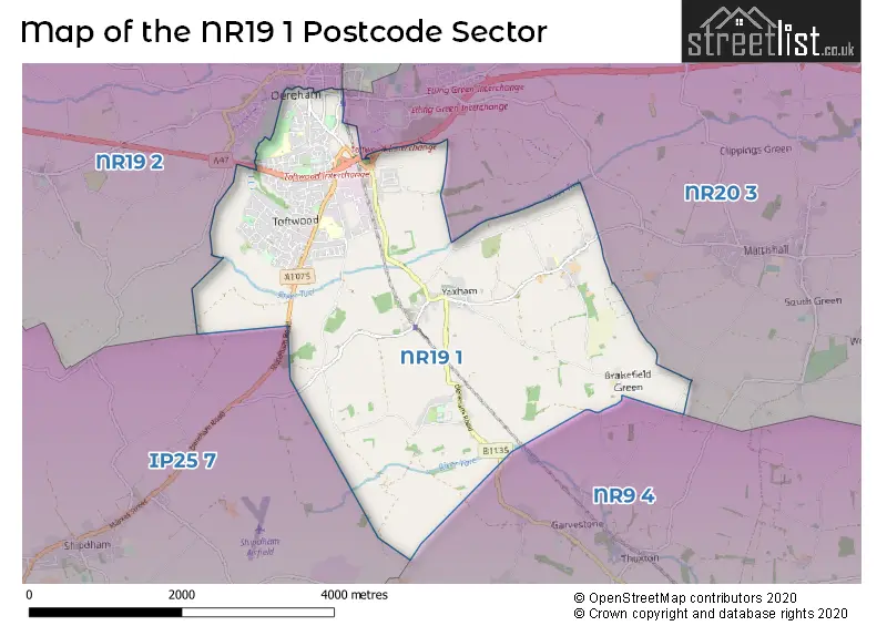
Map of the NR19 1 Postcode Sector
Explore the NR19 1 postcode sector by using our free interactive map.
| N | R | 1 | 9 | - | 1 | X | X |
| N | R | 1 | 9 | Space | 1 | Letter | Letter |
Official List of Streets
DEREHAM (199 Streets)
Yaxham (20 Streets)
Whinburgh (3 Streets)
Unofficial Streets or Alternative Spellings
Mattishall
YAXHAM ROAD ALDISS COURT BRAKEFIELD LANE CHAPEL MEWS CROSS WAY CUTHBERT COURT EAST VIEW FIELD LANE GAGMANS LANE GARVESTONE ROAD LARNERS DRIFT LOW LANE MILL LANE MOORGATE MOUSES BRIDGE (FOOTBRIDGE) MOUSES LANE NUNNS WAY PARKERS YARD PINNS LANE REAVEY COURT ROYSON WAY SAFARI WAY SAINT GEORGES DRIVE SAINT PETERS CLOSE SILVER SPRING ARABIANS SMEE DRIFT THE DODMANS THORP COURT TOLLERS LANE WAKES LANE WALTER ROADDEREHAM
COWPER ROAD GREENS ROAD HALL LANE MATSELL WAY NORWICH ROAD QUEBEC STREETGarvestone
DEREHAM ROAD MATTISHALL ROADShipdham
BIRDS CORNERScarning
FEN ROAD WASHBRIDGEWeather Forecast for NR19 1
Press Button to Show Forecast for Dereham
| Time Period | Icon | Description | Temperature | Rain Probability | Wind |
|---|---|---|---|---|---|
| 21:00 to 00:00 | Heavy rain | 8.0°C (feels like 5.0°C) | 93.00% | NE 11 mph |
Press Button to Show Forecast for Dereham
| Time Period | Icon | Description | Temperature | Rain Probability | Wind |
|---|---|---|---|---|---|
| 00:00 to 03:00 | Heavy rain | 8.0°C (feels like 5.0°C) | 94.00% | NE 11 mph | |
| 03:00 to 06:00 | Heavy rain | 9.0°C (feels like 7.0°C) | 95.00% | E 9 mph | |
| 06:00 to 09:00 | Light rain | 10.0°C (feels like 8.0°C) | 49.00% | SSE 11 mph | |
| 09:00 to 12:00 | Heavy rain | 11.0°C (feels like 9.0°C) | 58.00% | S 13 mph | |
| 12:00 to 15:00 | Thunder | 11.0°C (feels like 8.0°C) | 71.00% | WSW 16 mph | |
| 15:00 to 18:00 | Light rain | 8.0°C (feels like 4.0°C) | 54.00% | WSW 16 mph | |
| 18:00 to 21:00 | Cloudy | 8.0°C (feels like 6.0°C) | 46.00% | SW 11 mph | |
| 21:00 to 00:00 | Clear night | 7.0°C (feels like 5.0°C) | 2.00% | SSW 9 mph |
Press Button to Show Forecast for Dereham
| Time Period | Icon | Description | Temperature | Rain Probability | Wind |
|---|---|---|---|---|---|
| 00:00 to 03:00 | Clear night | 6.0°C (feels like 3.0°C) | 0.00% | SSW 9 mph | |
| 03:00 to 06:00 | Clear night | 5.0°C (feels like 2.0°C) | 0.00% | SSW 9 mph | |
| 06:00 to 09:00 | Sunny day | 6.0°C (feels like 3.0°C) | 0.00% | S 9 mph | |
| 09:00 to 12:00 | Sunny day | 12.0°C (feels like 9.0°C) | 0.00% | SSW 13 mph | |
| 12:00 to 15:00 | Cloudy | 14.0°C (feels like 11.0°C) | 5.00% | S 13 mph | |
| 15:00 to 18:00 | Partly cloudy (day) | 15.0°C (feels like 12.0°C) | 2.00% | S 13 mph | |
| 18:00 to 21:00 | Sunny day | 13.0°C (feels like 11.0°C) | 1.00% | SSE 11 mph | |
| 21:00 to 00:00 | Clear night | 9.0°C (feels like 7.0°C) | 0.00% | SSE 9 mph |
Press Button to Show Forecast for Dereham
| Time Period | Icon | Description | Temperature | Rain Probability | Wind |
|---|---|---|---|---|---|
| 00:00 to 03:00 | Clear night | 8.0°C (feels like 5.0°C) | 1.00% | SE 7 mph | |
| 03:00 to 06:00 | Partly cloudy (night) | 7.0°C (feels like 5.0°C) | 2.00% | ESE 7 mph | |
| 06:00 to 09:00 | Partly cloudy (day) | 9.0°C (feels like 8.0°C) | 2.00% | ESE 7 mph | |
| 09:00 to 12:00 | Cloudy | 14.0°C (feels like 12.0°C) | 7.00% | SE 9 mph | |
| 12:00 to 15:00 | Cloudy | 15.0°C (feels like 13.0°C) | 11.00% | SE 11 mph | |
| 15:00 to 18:00 | Cloudy | 16.0°C (feels like 14.0°C) | 9.00% | SE 11 mph | |
| 18:00 to 21:00 | Cloudy | 14.0°C (feels like 13.0°C) | 9.00% | ESE 9 mph | |
| 21:00 to 00:00 | Cloudy | 11.0°C (feels like 10.0°C) | 11.00% | ESE 7 mph |
Press Button to Show Forecast for Dereham
| Time Period | Icon | Description | Temperature | Rain Probability | Wind |
|---|---|---|---|---|---|
| 00:00 to 03:00 | Cloudy | 11.0°C (feels like 10.0°C) | 12.00% | ESE 7 mph | |
| 03:00 to 06:00 | Partly cloudy (night) | 11.0°C (feels like 10.0°C) | 7.00% | E 4 mph | |
| 06:00 to 09:00 | Cloudy | 11.0°C (feels like 11.0°C) | 7.00% | E 4 mph | |
| 09:00 to 12:00 | Partly cloudy (day) | 15.0°C (feels like 15.0°C) | 5.00% | ENE 7 mph | |
| 12:00 to 15:00 | Partly cloudy (day) | 18.0°C (feels like 17.0°C) | 6.00% | NE 7 mph | |
| 15:00 to 18:00 | Cloudy | 17.0°C (feels like 16.0°C) | 7.00% | NE 9 mph | |
| 18:00 to 21:00 | Partly cloudy (day) | 14.0°C (feels like 13.0°C) | 3.00% | NNE 9 mph | |
| 21:00 to 00:00 | Overcast | 11.0°C (feels like 10.0°C) | 10.00% | NNE 7 mph |
Schools and Places of Education Within the NR19 1 Postcode Sector
Dereham Church of England Junior Academy
Academy sponsor led
Gilpin's Ride, Dereham, Norfolk, NR19 1BJ
Head: Mrs Kelly Scott
Ofsted Rating: Good
Inspection: 2018-07-04 (2124 days ago)
Website: Visit Dereham Church of England Junior Academy Website
Phone: 01362693876
Number of Pupils: 413
Dereham, Toftwood Community Junior School
Community school
38 Westfield Road, Dereham, Norfolk, NR19 1JB
Head: Joanna Pedlow
Ofsted Rating: Good
Inspection: 2020-01-22 (1557 days ago)
Website: Visit Dereham, Toftwood Community Junior School Website
Phone: 01362694919
Number of Pupils: 345
Fred Nicholson School
Foundation special school
Westfield Road, Dereham, Norfolk, NR19 1JB
Head: Mrs Jane Hayman
Ofsted Rating: Good
Inspection: 2019-11-07 (1633 days ago)
Website: Visit Fred Nicholson School Website
Phone: 01362693915
Number of Pupils: 173
Grove House Infant and Nursery School
Academy converter
Gilpins Ride, Dereham, Norfolk, NR19 1BJ
Head: Mr Mark Cuenca-Farrow
Ofsted Rating: Good
Inspection: 2020-01-29 (1550 days ago)
Website: Visit Grove House Infant and Nursery School Website
Phone: 01362694379
Number of Pupils: 92
Toftwood Infant School
Foundation school
School Lane, Dereham, Norfolk, NR19 1LS
Head: Mrs Joanna Pedlow
Ofsted Rating: Good
Inspection: 2023-11-29 (150 days ago)
Website: Visit Toftwood Infant School Website
Phone: 01362692612
Number of Pupils: 225
House Prices in the NR19 1 Postcode Sector
| Type of Property | 2018 Average | 2018 Sales | 2017 Average | 2017 Sales | 2016 Average | 2016 Sales | 2015 Average | 2015 Sales |
|---|---|---|---|---|---|---|---|---|
| Detached | £279,558 | 74 | £283,550 | 67 | £280,904 | 63 | £239,952 | 80 |
| Semi-Detached | £201,985 | 48 | £184,013 | 63 | £168,602 | 56 | £153,992 | 52 |
| Terraced | £161,535 | 88 | £156,282 | 66 | £145,214 | 86 | £138,131 | 94 |
| Flats | £122,909 | 17 | £105,813 | 16 | £105,044 | 25 | £111,561 | 22 |
Important Postcodes NR19 1 in the Postcode Sector
NR19 1AE is the postcode for Orchard Surgery, Commercial Road, Norfolk Constabulary, Police Station, and Norfolk Constabulary, Police Station, 1 Commercial Road
NR19 1BG is the postcode for St. Nicholas House, Littlefields
NR19 1BJ is the postcode for MAIN BUILDING, Dereham Church of England Junior Academy, Gilpins Ride, MAIN BUILDING, Dereham Church of England Junior Academy, Gilpin's Ride, Grove House Infant and Nursery School,, Gilpins Ride, Grove House Nursery & Infant School, Gilpins Ride, Grove House Infant & Nursery School, Gilpins Ride, and YEAR 5 BLOCK, Dereham Church of England Junior Academy, Gilpins Ride
NR19 1DA is the postcode for Peddars Way Housing Association Ltd, Michael Chaplin House, Station Road
NR19 1DF is the postcode for Dereham Leisure Centre, Station Road
NR19 1DZ is the postcode for Norfolk County Council, Dereham Library, 59 High Street
NR19 1ED is the postcode for Dereham Church Infant School, St. Withburga Lane
NR19 1EE is the postcode for Breckland District Council, Elizabeth House, Walpole Loke, and Elizabeth House, Walpole Loke
NR19 1FD is the postcode for Breckland Business Centre, St. Withburga Lane
NR19 1JB is the postcode for Toftwood Community Junior School, 38 Westfield Road, Toftwood Junior School, 38 Westfield Road, and MAIN BLOCK, Fred Nicholson School, Westfield Road
NR19 1JG is the postcode for Dereham Community Hub, Rashs Green, and WORKSHOP, Dereham Community Hub, Rashs Green
NR19 1LS is the postcode for Toftwood Infant School, School Lane
NR19 1RU is the postcode for Yaxham C of E Primary School, Norwich Road
| The NR19 1 Sector is within these Local Authorities |
|
|---|---|
| The NR19 1 Sector is within these Counties |
|
| The NR19 1 Sector is within these Water Company Areas |
|