The NR11 7 postcode sector is within the county of Norfolk.
Did you know? According to the 2021 Census, the NR11 7 postcode sector is home to a bustling 3,095 residents!
Given that each sector allows for 400 unique postcode combinations. Letters C, I, K, M, O and V are not allowed in the last two letters of a postcode. With 186 postcodes already in use, this leaves 214 units available.
The largest settlement in the NR11 7 postal code is Erpingham followed by Aldborough, and Hanworth.
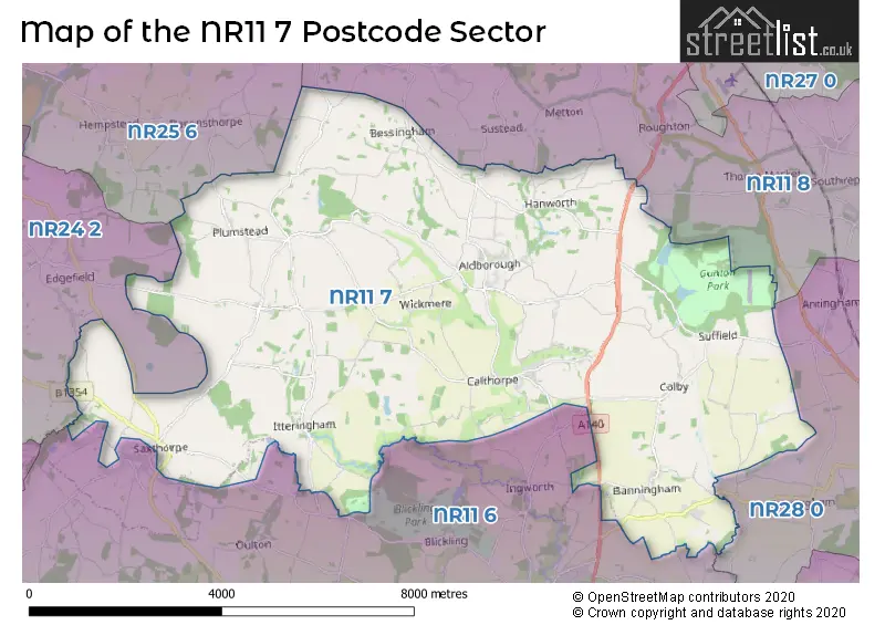
The NR11 7 Postcode shares a border with NR11 6 (Aylsham, Corpusty, Wood Dalling), NR11 8 (Mundesley, Southrepps, Roughton), NR24 2 (Briston, MELTON CONSTABLE, Edgefield), NR25 6 (HOLT, High Kelling, Bodham) and NR28 0 (NORTH WALSHAM, Trunch, Felmingham).
The sector is within the post town of NORWICH.
NR11 7 is a postcode sector within the NR11 postcode district which is within the NR Norwich postcode area.
The Royal Mail delivery office for the NR11 7 postal sector is the Aylsham Scale Payment Delivery Office and Sheringham Delivery Office.
The area of the NR11 7 postcode sector is 32.57 square miles which is 84.34 square kilometres or 20,841.58 square acres.
Waterways within the NR11 7 postcode sector include the River Bure.


Map of the NR11 7 Postcode Sector
Explore the NR11 7 postcode sector by using our free interactive map.
| N | R | 1 | 1 | - | 7 | X | X |
| N | R | 1 | 1 | Space | 7 | Letter | Letter |
Official List of Streets
Alby (8 Streets)
Calthorpe (3 Streets)
Wickmere (7 Streets)
Saxthorpe (6 Streets)
Plumstead (8 Streets)
Ingworth (1 Streets)
Matlaske (7 Streets)
Thurgarton (5 Streets)
Erpingham (16 Streets)
Barningham (2 Streets)
Suffield (7 Streets)
Hanworth (5 Streets)
Aldborough (10 Streets)
Bessingham (5 Streets)
Banningham (4 Streets)
Itteringham (7 Streets)
Little Barningham (5 Streets)
Mannington (1 Streets)
Unofficial Streets or Alternative Spellings
Felmingham
AYLSHAM ROADTuttington
BANNINGHAM ROADAylsham
BANNINGHAM ROAD BLICKLING ROADGresham
BARNINGHAM ROADBarningham
GRESHAM ROAD RECTORY ROADCorpusty
THE STREETEdgefield
PLUMSTEAD ROADBriston
NORWICH ROADWeather Forecast for NR11 7
Press Button to Show Forecast for Mannington Hall
| Time Period | Icon | Description | Temperature | Rain Probability | Wind |
|---|---|---|---|---|---|
| 12:00 to 15:00 | Overcast | 8.0°C (feels like 5.0°C) | 52.00% | ENE 11 mph | |
| 15:00 to 18:00 | Light rain | 8.0°C (feels like 5.0°C) | 42.00% | NE 11 mph | |
| 18:00 to 21:00 | Overcast | 8.0°C (feels like 5.0°C) | 19.00% | NE 11 mph | |
| 21:00 to 00:00 | Overcast | 8.0°C (feels like 5.0°C) | 50.00% | NE 11 mph |
Press Button to Show Forecast for Mannington Hall
| Time Period | Icon | Description | Temperature | Rain Probability | Wind |
|---|---|---|---|---|---|
| 00:00 to 03:00 | Heavy rain | 8.0°C (feels like 5.0°C) | 89.00% | NE 11 mph | |
| 03:00 to 06:00 | Heavy rain | 9.0°C (feels like 7.0°C) | 91.00% | NE 9 mph | |
| 06:00 to 09:00 | Light rain | 10.0°C (feels like 7.0°C) | 58.00% | ESE 11 mph | |
| 09:00 to 12:00 | Heavy rain | 11.0°C (feels like 8.0°C) | 82.00% | SW 13 mph | |
| 12:00 to 15:00 | Heavy rain shower (day) | 11.0°C (feels like 8.0°C) | 69.00% | WSW 13 mph | |
| 15:00 to 18:00 | Light rain shower (day) | 9.0°C (feels like 6.0°C) | 45.00% | W 13 mph | |
| 18:00 to 21:00 | Cloudy | 9.0°C (feels like 7.0°C) | 10.00% | WSW 9 mph | |
| 21:00 to 00:00 | Clear night | 7.0°C (feels like 5.0°C) | 3.00% | SW 7 mph |
Press Button to Show Forecast for Mannington Hall
| Time Period | Icon | Description | Temperature | Rain Probability | Wind |
|---|---|---|---|---|---|
| 00:00 to 03:00 | Partly cloudy (night) | 6.0°C (feels like 4.0°C) | 2.00% | SW 7 mph | |
| 03:00 to 06:00 | Clear night | 5.0°C (feels like 3.0°C) | 1.00% | SSW 7 mph | |
| 06:00 to 09:00 | Sunny day | 6.0°C (feels like 4.0°C) | 1.00% | S 7 mph | |
| 09:00 to 12:00 | Sunny day | 12.0°C (feels like 10.0°C) | 1.00% | S 9 mph | |
| 12:00 to 15:00 | Cloudy | 14.0°C (feels like 11.0°C) | 6.00% | S 11 mph | |
| 15:00 to 18:00 | Partly cloudy (day) | 14.0°C (feels like 11.0°C) | 2.00% | S 13 mph | |
| 18:00 to 21:00 | Sunny day | 12.0°C (feels like 10.0°C) | 1.00% | SSE 9 mph | |
| 21:00 to 00:00 | Clear night | 9.0°C (feels like 7.0°C) | 1.00% | SE 9 mph |
Press Button to Show Forecast for Mannington Hall
| Time Period | Icon | Description | Temperature | Rain Probability | Wind |
|---|---|---|---|---|---|
| 00:00 to 03:00 | Partly cloudy (night) | 8.0°C (feels like 6.0°C) | 1.00% | SE 7 mph | |
| 03:00 to 06:00 | Mist | 7.0°C (feels like 5.0°C) | 16.00% | ESE 7 mph | |
| 06:00 to 09:00 | Cloudy | 9.0°C (feels like 8.0°C) | 7.00% | E 7 mph | |
| 09:00 to 12:00 | Cloudy | 13.0°C (feels like 12.0°C) | 9.00% | ESE 7 mph | |
| 12:00 to 15:00 | Cloudy | 15.0°C (feels like 13.0°C) | 9.00% | SE 9 mph | |
| 15:00 to 18:00 | Cloudy | 15.0°C (feels like 13.0°C) | 8.00% | ESE 11 mph | |
| 18:00 to 21:00 | Cloudy | 13.0°C (feels like 12.0°C) | 6.00% | ESE 9 mph | |
| 21:00 to 00:00 | Cloudy | 11.0°C (feels like 10.0°C) | 10.00% | E 7 mph |
Schools and Places of Education Within the NR11 7 Postcode Sector
Aldborough Primary School
Foundation school
Alby Hill, Norwich, Norfolk, NR11 7PH
Head: Mrs Helen Bearman
Ofsted Rating: Good
Inspection: 2019-03-20 (1865 days ago)
Website: Visit Aldborough Primary School Website
Phone: 01263761264
Number of Pupils: 124
Colby Primary School
Community school
Bridge Road, Norwich, Norfolk, NR11 7EA
Head: Mrs Christine Mead
Ofsted Rating: Good
Inspection: 2022-06-28 (669 days ago)
Website: Visit Colby Primary School Website
Phone: 01263733381
Number of Pupils: 141
Erpingham Voluntary Controlled Church of England Primary School
Voluntary controlled school
School Road, Norwich, Norfolk, NR11 7QY
Head: Mr John Neenan
Ofsted Rating: Requires improvement
Inspection: 2023-10-11 (199 days ago)
Website: Visit Erpingham Voluntary Controlled Church of England Primary School Website
Phone: 01263761365
Number of Pupils: 59
House Prices in the NR11 7 Postcode Sector
| Type of Property | 2018 Average | 2018 Sales | 2017 Average | 2017 Sales | 2016 Average | 2016 Sales | 2015 Average | 2015 Sales |
|---|---|---|---|---|---|---|---|---|
| Detached | £359,002 | 27 | £369,524 | 21 | £361,917 | 35 | £420,103 | 23 |
| Semi-Detached | £254,023 | 13 | £246,080 | 20 | £242,534 | 7 | £179,792 | 12 |
| Terraced | £329,544 | 7 | £211,517 | 9 | £256,300 | 10 | £227,783 | 6 |
| Flats | £0 | 0 | £0 | 0 | £200,000 | 1 | £0 | 0 |
Important Postcodes NR11 7 in the Postcode Sector
NR11 7NN is the postcode for The Surgery, Chapel Road
NR11 7PH is the postcode for Aldborough Primary School, Alby Hill, and MAIN BUILDING, Aldborough Cp School, Alby Hill
| The NR11 7 Sector is within these Local Authorities |
|
|---|---|
| The NR11 7 Sector is within these Counties |
|
| The NR11 7 Sector is within these Water Company Areas |
|
Tourist Attractions within the NR11 7 Postcode Area
We found 1 visitor attractions within the NR11 postcode area
| Mannington Gardens |
|---|
| Historic Properties |
| Historic House / House and Garden / Palace |
| View Mannington Gardens on Google Maps |