The NR26 8 postcode sector is within the county of Norfolk.
Did you know? According to the 2021 Census, the NR26 8 postcode sector is home to a bustling 8,193 residents!
Given that each sector allows for 400 unique postcode combinations. Letters C, I, K, M, O and V are not allowed in the last two letters of a postcode. With 288 postcodes already in use, this leaves 112 units available.
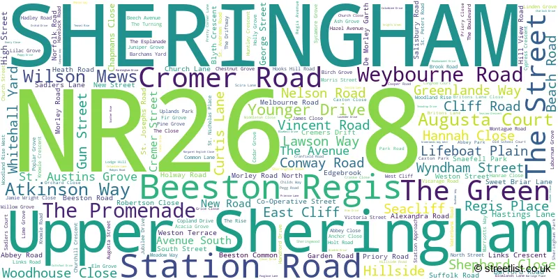
The largest settlement in the NR26 8 postal code is SHERINGHAM followed by Beeston Regis, and Upper Sheringham.
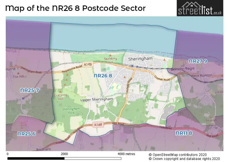
The NR26 8 Postcode shares a border with NR11 8 (Mundesley, Southrepps, Roughton), NR25 6 (HOLT, High Kelling, Bodham), NR25 7 (Blakeney, Weybourne, Cley) and NR27 9 (CROMER, West Runton, East Runton).
The sector is within the post town of SHERINGHAM.
NR26 8 is a postcode sector within the NR26 postcode district which is within the NR Norwich postcode area.
The Royal Mail delivery office for the NR26 8 postal sector is the Sheringham Delivery Office.
The area of the NR26 8 postcode sector is 4.64 square miles which is 12.03 square kilometres or 2,972.50 square acres.

Map of the NR26 8 Postcode Sector
Explore the NR26 8 postcode sector by using our free interactive map.
| N | R | 2 | 6 | - | 8 | X | X |
| N | R | 2 | 6 | Space | 8 | Letter | Letter |
Official List of Streets
SHERINGHAM (164 Streets)
Beeston Regis (13 Streets)
Upper Sheringham (18 Streets)
Unofficial Streets or Alternative Spellings
Beeston Regis
NELSON ROADAylmerton
HOLT ROADWest Runton
CALVES WELL LANE BUTTS LANE COAST ROAD LOUDWATER COURT OAK GROVE PROMENADE RAILWAY APPROACH SAINT ANDREWS ROAD SAINT AUSTINS GROVE SAINT JOSEPHS ROAD SAINT NICHOLAS PLACE SAINT PETERS ROAD SEAVIEW SWEETBRIAR LANE THE COURTYARD TRENTHAM DRIVE WOODLAND RISE (WEST)SHERINGHAM
CO-OPERATIVE STREETEast Beckham
GIBBET LANEWest Beckham
SHERINGHAM ROADWeybourne
SHERINGHAM ROADBodham
CROMER ROADWeather Forecast for NR26 8
Press Button to Show Forecast for Sheringham Youth Hostel
| Time Period | Icon | Description | Temperature | Rain Probability | Wind |
|---|---|---|---|---|---|
| 09:00 to 12:00 | Cloudy | 8.0°C (feels like 5.0°C) | 38.00% | ENE 13 mph | |
| 12:00 to 15:00 | Overcast | 8.0°C (feels like 5.0°C) | 47.00% | ENE 13 mph | |
| 15:00 to 18:00 | Overcast | 8.0°C (feels like 4.0°C) | 17.00% | NE 16 mph | |
| 18:00 to 21:00 | Overcast | 8.0°C (feels like 4.0°C) | 13.00% | NE 16 mph | |
| 21:00 to 00:00 | Overcast | 8.0°C (feels like 5.0°C) | 49.00% | NE 13 mph |
Press Button to Show Forecast for Sheringham Youth Hostel
| Time Period | Icon | Description | Temperature | Rain Probability | Wind |
|---|---|---|---|---|---|
| 00:00 to 03:00 | Heavy rain | 8.0°C (feels like 5.0°C) | 88.00% | NE 16 mph | |
| 03:00 to 06:00 | Heavy rain | 9.0°C (feels like 6.0°C) | 91.00% | NE 13 mph | |
| 06:00 to 09:00 | Light rain | 10.0°C (feels like 7.0°C) | 58.00% | ESE 13 mph | |
| 09:00 to 12:00 | Heavy rain | 11.0°C (feels like 8.0°C) | 71.00% | SW 16 mph | |
| 12:00 to 15:00 | Heavy rain | 10.0°C (feels like 7.0°C) | 83.00% | WSW 16 mph | |
| 15:00 to 18:00 | Light rain shower (day) | 9.0°C (feels like 6.0°C) | 45.00% | W 16 mph | |
| 18:00 to 21:00 | Cloudy | 9.0°C (feels like 6.0°C) | 9.00% | WSW 9 mph | |
| 21:00 to 00:00 | Partly cloudy (night) | 7.0°C (feels like 5.0°C) | 2.00% | SW 9 mph |
Press Button to Show Forecast for Sheringham Youth Hostel
| Time Period | Icon | Description | Temperature | Rain Probability | Wind |
|---|---|---|---|---|---|
| 00:00 to 03:00 | Partly cloudy (night) | 7.0°C (feels like 4.0°C) | 1.00% | SW 9 mph | |
| 03:00 to 06:00 | Clear night | 6.0°C (feels like 3.0°C) | 1.00% | SSW 9 mph | |
| 06:00 to 09:00 | Sunny day | 6.0°C (feels like 3.0°C) | 1.00% | S 9 mph | |
| 09:00 to 12:00 | Sunny day | 11.0°C (feels like 9.0°C) | 0.00% | S 11 mph | |
| 12:00 to 15:00 | Cloudy | 14.0°C (feels like 11.0°C) | 6.00% | S 11 mph | |
| 15:00 to 18:00 | Partly cloudy (day) | 14.0°C (feels like 11.0°C) | 2.00% | SSE 13 mph | |
| 18:00 to 21:00 | Sunny day | 12.0°C (feels like 10.0°C) | 1.00% | SE 11 mph | |
| 21:00 to 00:00 | Clear night | 9.0°C (feels like 7.0°C) | 1.00% | SE 11 mph |
Press Button to Show Forecast for Sheringham Youth Hostel
| Time Period | Icon | Description | Temperature | Rain Probability | Wind |
|---|---|---|---|---|---|
| 00:00 to 03:00 | Clear night | 8.0°C (feels like 6.0°C) | 1.00% | SE 9 mph | |
| 03:00 to 06:00 | Partly cloudy (night) | 8.0°C (feels like 5.0°C) | 3.00% | SE 9 mph | |
| 06:00 to 09:00 | Mist | 9.0°C (feels like 7.0°C) | 17.00% | E 9 mph | |
| 09:00 to 12:00 | Overcast | 12.0°C (feels like 11.0°C) | 13.00% | E 9 mph | |
| 12:00 to 15:00 | Cloudy | 14.0°C (feels like 12.0°C) | 8.00% | ESE 11 mph | |
| 15:00 to 18:00 | Cloudy | 14.0°C (feels like 12.0°C) | 6.00% | ESE 11 mph | |
| 18:00 to 21:00 | Cloudy | 12.0°C (feels like 10.0°C) | 6.00% | ESE 11 mph | |
| 21:00 to 00:00 | Cloudy | 11.0°C (feels like 9.0°C) | 10.00% | E 9 mph |
Schools and Places of Education Within the NR26 8 Postcode Sector
Sheringham Community Primary School
Community school
Cooper Road, Sheringham, Norfolk, NR26 8UH
Head: Mrs Rachael Carter
Ofsted Rating: Good
Inspection: 2023-11-29 (150 days ago)
Website: Visit Sheringham Community Primary School Website
Phone: 01263823848
Number of Pupils: 449
Sheringham High School
Academy converter
Holt Road, Sheringham, Norfolk, NR26 8ND
Head: Mr Alastair Ogle
Ofsted Rating: Good
Inspection: 2023-06-21 (311 days ago)
Website: Visit Sheringham High School Website
Phone: 01263822363
Number of Pupils: 737
Sheringham Woodfields School
Foundation special school
Holt Road, Sheringham, Norfolk, NR26 8ND
Head: Miss Annette Maconochie
Ofsted Rating: Outstanding
Inspection: 2019-01-23 (1921 days ago)
Website: Visit Sheringham Woodfields School Website
Phone: 01263820520
Number of Pupils: 144
House Prices in the NR26 8 Postcode Sector
| Type of Property | 2018 Average | 2018 Sales | 2017 Average | 2017 Sales | 2016 Average | 2016 Sales | 2015 Average | 2015 Sales |
|---|---|---|---|---|---|---|---|---|
| Detached | £341,626 | 87 | £334,950 | 95 | £308,904 | 90 | £305,566 | 109 |
| Semi-Detached | £262,912 | 29 | £263,312 | 43 | £238,624 | 35 | £232,099 | 39 |
| Terraced | £242,298 | 29 | £208,491 | 33 | £215,729 | 35 | £212,958 | 45 |
| Flats | £215,298 | 84 | £160,542 | 51 | £154,427 | 61 | £168,650 | 60 |
Important Postcodes NR26 8 in the Postcode Sector
NR26 8ND is the postcode for FLOOR 1, FLOOR 2 MAIN BLOCK, Sheringham High School, Holt Road, Sheringham Woodfields School, Holt Road, SIXTH FORM BLOCK, Sheringham High School, Holt Road, MILLENNIUM BUILDING, Sheringham High School, Holt Road, and MAIN BLOCK, Sheringham High School, Holt Road
NR26 8RT is the postcode for Sheringham Health Centre, Cromer Road, and SHERINGHAM MEDICAL PRACTICE, Sheringham Health Centre, Cromer Road
NR26 8UH is the postcode for MAIN BUILDING, Sheringham Community Primary School, Cooper Road, and Sheringham Community Primary School, Cooper Road
NR26 8WD is the postcode for Splash Leisure Complex, Weybourne Road, SPLASH LEISURE COMPLEX, WEYBOURNE ROAD, SHERINGHAM, and The Reef Leisure Centre, Weybourne Road
| The NR26 8 Sector is within these Local Authorities |
|
|---|---|
| The NR26 8 Sector is within these Counties |
|
| The NR26 8 Sector is within these Water Company Areas |
|
Tourist Attractions within the NR26 8 Postcode Area
We found 1 visitor attractions within the NR26 postcode area
| The Poppy Line (North Norfolk Railway) |
|---|
| Historic Properties |
| Other Historic / Scenic Transport Operator |
| View The Poppy Line (North Norfolk Railway) on Google Maps |