The NR4 7 postcode sector is within the county of Norfolk.
Did you know? According to the 2021 Census, the NR4 7 postcode sector is home to a bustling 15,707 residents!
Given that each sector allows for 400 unique postcode combinations. Letters C, I, K, M, O and V are not allowed in the last two letters of a postcode. With 263 postcodes already in use, this leaves 137 units available.
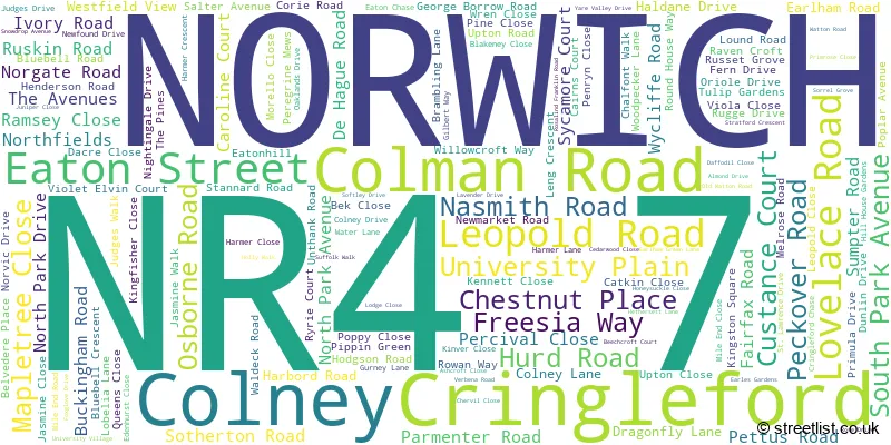
The largest settlement in the NR4 7 postal code is NORWICH followed by Cringleford, and Colney.
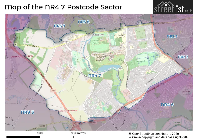
The NR4 7 Postcode shares a border with NR9 3 (Hethersett, Little Melton, Bawburgh), NR2 3 (NORWICH), NR4 6 (NORWICH, Cringleford, Keswick), NR5 8 (NORWICH), NR2 2 (NORWICH) and NR5 9 (NORWICH).
The sector is within the post town of NORWICH.
NR4 7 is a postcode sector within the NR4 postcode district which is within the NR Norwich postcode area.
The Royal Mail delivery office for the NR4 7 postal sector is the Norwich Delivery Office.
The area of the NR4 7 postcode sector is 3.73 square miles which is 9.67 square kilometres or 2,388.99 square acres.
The NR4 7 postcode sector is crossed by the A11 Major A road.
The NR4 7 postcode sector is crossed by the A47 Major A road.
Waterways within the NR4 7 postcode sector include the River Yare.

Map of the NR4 7 Postcode Sector
Explore the NR4 7 postcode sector by using our free interactive map.
| N | R | 4 | - | 7 | X | X |
| N | R | 4 | Space | 7 | Letter | Letter |
Official List of Streets
Cringleford (55 Streets)
NORWICH (96 Streets)
Unofficial Streets or Alternative Spellings
NORWICH
BACON ROAD BEVERLEY ROAD CHESTNUT HILL CHURCH AVENUE EATONHILL ELIZABETH FRY ROAD FARROW ROAD FRIENDS ROAD GIPSY LANE HIGHLAND ROAD JESSOPP ROAD KINGHORN ROAD LODGE CLOSE MORNINGTON ROAD MURIEL ROAD WILBERFORCE ROAD ATCHINSON AVENUE BATESON ROAD BIRCH WAY BLUEBELL WALK BRYONY PLACE BUNNETT SQUARE CARPENTERS COURT CHANCELLORS DRIVE CHURCH FARM CLOVER COURT COACH HOUSE COURT COLNEY WOODLAND WALK CORNFLOWER WAY COW DRIVE FIVEWAYS ROUNDABOUT FLEMING PLACE HARTS LANE MALLOW COURT MATHEMATICAL BRIDGE MISTLETOW COURT NEWFOUND COURT NEWMARKET ROAD SLIP ROAD NORFOLK ROAD NORWICH SOUTHERN BYPASS OAK WALK SAINT LAWRENCE DRIVE STEVE VISSCHER WAY SUFFOLK ROAD THE COURTYARD THE PARADE THE STREET THICKTHORN INTERCHANGE TOLLGATE WAY UNIVERSITY DRIVE UPLANDS COURT VALLEY WALK VILLAGE CLOSE WATER MEADOWSEaton
CHURCH LANECringleford
NEWMARKET ROADLittle Melton
SCHOOL LANEBarford
WATTON ROADWeather Forecast for NR4 7
Press Button to Show Forecast for Norwich Youth Hostel
| Time Period | Icon | Description | Temperature | Rain Probability | Wind |
|---|---|---|---|---|---|
| 15:00 to 18:00 | Overcast | 9.0°C (feels like 7.0°C) | 15.00% | ESE 7 mph | |
| 18:00 to 21:00 | Cloudy | 9.0°C (feels like 7.0°C) | 13.00% | ENE 7 mph | |
| 21:00 to 00:00 | Clear night | 6.0°C (feels like 5.0°C) | 1.00% | NE 4 mph |
Press Button to Show Forecast for Norwich Youth Hostel
| Time Period | Icon | Description | Temperature | Rain Probability | Wind |
|---|---|---|---|---|---|
| 00:00 to 03:00 | Partly cloudy (night) | 6.0°C (feels like 4.0°C) | 1.00% | ENE 4 mph | |
| 03:00 to 06:00 | Cloudy | 6.0°C (feels like 4.0°C) | 8.00% | NE 4 mph | |
| 06:00 to 09:00 | Overcast | 7.0°C (feels like 5.0°C) | 53.00% | NE 7 mph | |
| 09:00 to 12:00 | Light rain | 8.0°C (feels like 5.0°C) | 53.00% | ENE 9 mph | |
| 12:00 to 15:00 | Light rain | 9.0°C (feels like 6.0°C) | 50.00% | ENE 11 mph | |
| 15:00 to 18:00 | Overcast | 10.0°C (feels like 7.0°C) | 13.00% | NE 11 mph | |
| 18:00 to 21:00 | Overcast | 9.0°C (feels like 7.0°C) | 11.00% | NE 9 mph | |
| 21:00 to 00:00 | Overcast | 9.0°C (feels like 6.0°C) | 50.00% | NE 9 mph |
Press Button to Show Forecast for Norwich Youth Hostel
| Time Period | Icon | Description | Temperature | Rain Probability | Wind |
|---|---|---|---|---|---|
| 00:00 to 03:00 | Heavy rain | 9.0°C (feels like 6.0°C) | 86.00% | NE 9 mph | |
| 03:00 to 06:00 | Heavy rain | 9.0°C (feels like 7.0°C) | 90.00% | NE 9 mph | |
| 06:00 to 09:00 | Heavy rain | 10.0°C (feels like 8.0°C) | 87.00% | ENE 9 mph | |
| 09:00 to 12:00 | Heavy rain shower (day) | 11.0°C (feels like 8.0°C) | 66.00% | SW 13 mph | |
| 12:00 to 15:00 | Heavy rain shower (day) | 11.0°C (feels like 8.0°C) | 64.00% | W 13 mph | |
| 15:00 to 18:00 | Light rain shower (day) | 10.0°C (feels like 8.0°C) | 45.00% | W 13 mph | |
| 18:00 to 21:00 | Cloudy | 10.0°C (feels like 8.0°C) | 16.00% | WSW 9 mph | |
| 21:00 to 00:00 | Partly cloudy (night) | 8.0°C (feels like 6.0°C) | 4.00% | SW 7 mph |
Press Button to Show Forecast for Norwich Youth Hostel
| Time Period | Icon | Description | Temperature | Rain Probability | Wind |
|---|---|---|---|---|---|
| 00:00 to 03:00 | Cloudy | 7.0°C (feels like 5.0°C) | 6.00% | SW 7 mph | |
| 03:00 to 06:00 | Clear night | 6.0°C (feels like 4.0°C) | 2.00% | SSW 7 mph | |
| 06:00 to 09:00 | Sunny day | 7.0°C (feels like 4.0°C) | 1.00% | S 7 mph | |
| 09:00 to 12:00 | Sunny day | 12.0°C (feels like 10.0°C) | 1.00% | S 9 mph | |
| 12:00 to 15:00 | Cloudy | 14.0°C (feels like 12.0°C) | 9.00% | S 11 mph | |
| 15:00 to 18:00 | Partly cloudy (day) | 14.0°C (feels like 12.0°C) | 4.00% | S 11 mph | |
| 18:00 to 21:00 | Sunny day | 13.0°C (feels like 11.0°C) | 1.00% | SSE 9 mph | |
| 21:00 to 00:00 | Clear night | 9.0°C (feels like 8.0°C) | 1.00% | SE 7 mph |
Press Button to Show Forecast for Norwich Youth Hostel
| Time Period | Icon | Description | Temperature | Rain Probability | Wind |
|---|---|---|---|---|---|
| 00:00 to 03:00 | Partly cloudy (night) | 8.0°C (feels like 6.0°C) | 3.00% | SE 7 mph | |
| 03:00 to 06:00 | Partly cloudy (night) | 7.0°C (feels like 6.0°C) | 4.00% | ESE 7 mph | |
| 06:00 to 09:00 | Cloudy | 10.0°C (feels like 8.0°C) | 9.00% | E 7 mph | |
| 09:00 to 12:00 | Cloudy | 13.0°C (feels like 12.0°C) | 11.00% | ESE 7 mph | |
| 12:00 to 15:00 | Cloudy | 15.0°C (feels like 14.0°C) | 11.00% | SE 9 mph | |
| 15:00 to 18:00 | Cloudy | 16.0°C (feels like 14.0°C) | 8.00% | SE 9 mph | |
| 18:00 to 21:00 | Cloudy | 14.0°C (feels like 13.0°C) | 7.00% | ESE 9 mph | |
| 21:00 to 00:00 | Cloudy | 12.0°C (feels like 11.0°C) | 12.00% | E 7 mph |
Schools and Places of Education Within the NR4 7 Postcode Sector
City Academy Norwich
Academy sponsor led
299 Bluebell Road, Norwich, Norfolk, NR4 7LP
Head: Mrs Jo Franklin
Ofsted Rating: Serious Weaknesses
Inspection: 2022-11-23 (520 days ago)
Website: Visit City Academy Norwich Website
Phone:
Number of Pupils: 699
Cringleford CE VA Primary School
Voluntary aided school
Dragonfly Lane, Norwich, Norfolk, NR4 7JR
Head: Mrs Julia Humphrey
Ofsted Rating: Outstanding
Inspection: 2022-11-17 (526 days ago)
Website: Visit Cringleford CE VA Primary School Website
Phone: 01603454946
Number of Pupils: 442
Eaton Hall Specialist Academy
Academy special converter
Pettus Road, Norwich, Norfolk, NR4 7BU
Head: Mr Peter Lambert
Ofsted Rating: Good
Inspection: 2023-06-06 (325 days ago)
Website: Visit Eaton Hall Specialist Academy Website
Phone: 01603457480
Number of Pupils: 52
The Clare School
Foundation special school
South Park Avenue, Norwich, Norfolk, NR4 7AU
Head: Miss Rebecca Wicks
Ofsted Rating: Outstanding
Inspection: 2019-11-06 (1633 days ago)
Website: Visit The Clare School Website
Phone: 01603454199
Number of Pupils: 121
University of East Anglia
Higher education institutions
The Registry, Norwich, Norfolk, NR4 7TJ
Head: Professor David Richardson
Ofsted Rating: Good
Inspection: 2023-12-08 (140 days ago)
Website: Visit University of East Anglia Website
Phone: 01603456161
Number of Pupils: 0
House Prices in the NR4 7 Postcode Sector
| Type of Property | 2018 Average | 2018 Sales | 2017 Average | 2017 Sales | 2016 Average | 2016 Sales | 2015 Average | 2015 Sales |
|---|---|---|---|---|---|---|---|---|
| Detached | £413,873 | 48 | £442,707 | 56 | £389,995 | 65 | £374,634 | 99 |
| Semi-Detached | £293,577 | 58 | £277,608 | 96 | £267,068 | 58 | £268,578 | 53 |
| Terraced | £252,596 | 54 | £236,141 | 58 | £224,272 | 46 | £205,015 | 51 |
| Flats | £218,744 | 146 | £160,030 | 41 | £137,234 | 17 | £123,070 | 20 |
Important Postcodes NR4 7 in the Postcode Sector
NR4 7AU is the postcode for The Clare School, South Park Avenue, MAIN BUILDING, Colman Junior School, South Park Avenue, SWIMMING POOL, Colman Junior School, South Park Avenue, SENSORY SUPPORT, The Clare School, South Park Avenue, and Main Block, The Clare School, South Park Avenue
NR4 7AW is the postcode for Colman Infant School, Colman Road
NR4 7BU is the postcode for Eaton Hall Specialist Academy, Pettus Road
NR4 7DS is the postcode for Bluebell Primary School, Lovelace Road
NR4 7HG is the postcode for COLEMAN ROAD OFFICES, Colman Road Health Centre, 169 Colman Road
NR4 7JR is the postcode for Cringleford Primary School, 80-88 Dragonfly Lane
NR4 7LP is the postcode for Community Pool, City Academy, 299 Bluebell Road, The Hub, City Academy, 299 Bluebell Road, and City Academy, 299 Bluebell Road
NR4 7NU is the postcode for EARLHAM SPINNEY COMMUNITY EDUCATION CENTRE, City Academy, Earlham Road, MAIN BUILDING, City Academy, Earlham Road, and MAIN BLOCK, Earlham High School, Earlham Road
NR4 7QE is the postcode for Norfolk Community Health and Care NHS Trust, 378 Unthank Road
NR4 7QX is the postcode for Castle Partnership Medical Practice, Mile End Road Surgery, 29 Mile End Road
NR4 7TJ is the postcode for PASTON HOUSE, University of East Anglia, Earlham Road, SUFFOLK TERRACE, University of East Anglia, Earlham Road, REGISTRY, University of East Anglia, Earlham Road, COLMAN HOUSE G, University of East Anglia, Earlham Road, VILLAGE BLOCK E, University of East Anglia, Earlham Road, SPORTSPARK, University of East Anglia, Earlham Road, CROME COURT, University of East Anglia, Earlham Road, BROWN HOUSE, University of East Anglia, Earlham Road, MUSIC CENTRE, University of East Anglia, Earlham Road, ESTATES, University of East Anglia, Earlham Road, EARLHAM HALL, University of East Anglia, Earlham Road, NORFOLK TERRACE, University of East Anglia, Earlham Road, ORWELL AND WOLFSON, University of East Anglia, Earlham Road, MULTIFAITH CENTRE, University of East Anglia, Earlham Road, CONSTABLE TERRACE C AND D, University of East Anglia, Earlham Road, SUFFOLK WALK, University of East Anglia, Earlham Road, LIBRARY & CENTRAL LIBRARY EXTENSION, University of East Anglia, Earlham Road, SAINSBURY CENTRE FOR VISUAL ARTS, University of East Anglia, Earlham Road, CHEMISTRY, University of East Anglia, Earlham Road, HEALTH AND COMMUNITY CENTRE, University of East Anglia, Earlham Road, LAWRENCE STENHOUSE, University of East Anglia, Earlham Road, CAREERS CENTRAL PLUS,, University of East Anglia, Earlham Road, UNION HOUSE, University of East Anglia, Earlham Road, ARTS, University of East Anglia, Earlham Road, DEAN OF STUDENTS OFFICE, University of East Anglia, Earlham Road, Building 60, University of East Anglia, Earlham Road, BLACKDALE ANNEX, University of East Anglia, Earlham Road, KETT HOUSE, University of East Anglia, Earlham Road, VILLAGE BLOCK G, University of East Anglia, Earlham Road, LECTURE THEATRES, University of East Anglia, Earlham Road, MARY CHAPMAN COURT, University of East Anglia, Earlham Road, DEV FARM, University of East Anglia, Earlham Road, DRAMA STUDIO, University of East Anglia, Earlham Road, BIOMASS ENERGY CENTRE, University of East Anglia, Earlham Road, SPORTS PAVILLION, University of East Anglia, Earlham Road, WOOD HALL, University of East Anglia, Earlham Road, ITCS COMPUTING CENTRE, University of East Anglia, Earlham Road, VICTORY HOUSE, University of East Anglia, Earlham Road, INTO CENTRE, University of East Anglia, Earlham Road, CHANCELLOR DRIVE ANNEXE, University of East Anglia, Earlham Road, CONSTABLE TERRACE A AND B, University of East Anglia, Earlham Road, THE ENTERPRISE CENTRE, University of East Anglia, Earlham Road, NAM EDITH CAVELL, University of East Anglia, Earlham Road, CAREERS CENTRE, University of East Anglia, Earlham Road, CLIMATIC RESEARCH UNIT, University of East Anglia, Earlham Road, BIOLOGY, University of East Anglia, Earlham Road, THOMAS PAINE STUDY CENTRE, University of East Anglia, Earlham Road, BOB CHAMPION, University of East Anglia, Earlham Road, ENVIRONMENTAL, University of East Anglia, Earlham Road, 134 BARTON HOUSE, University of East Anglia, Earlham Road, NELSON COURT, University of East Anglia, Earlham Road, University of East Anglia, Earlham Road, VILLAGE BLOCK F, University of East Anglia, Earlham Road, JULIAN STUDY CENTRE BUILDING 57, University of East Anglia, Earlham Road, BRITTEN HOUSE, University of East Anglia, Earlham Road, ZICER BUILDING, University of East Anglia, Earlham Road, QUEENS BUILDING, University of East Anglia, Earlham Road, Elizabeth Fry Building, University of East Anglia, 135 HICKLING HOUSE, University of East Anglia, Earlham Road, MEDICAL SCHOOL, University of East Anglia, Earlham Road, RESTAURANT BUILDING, University of East Anglia, Earlham Road, CONGREGATION HALL, University of East Anglia, Earlham Road, BIOMEDICAL RESEARCH CENTRE, University of East Anglia, Earlham Road, and COLMAN HOUSE F, University of East Anglia, Earlham Road
NR4 7TL is the postcode for VLLAGE-BLOCK D, U E A, University Village, VILLAGE COURTYARD B, U E A, University Village, YEW, U E A, University Village, HAWTHORNE, U E A, University Village, OAK, U E A, University Village, WILLOW, U E A, University Village, ASH, U E A, University Village, VILLAGE COURTYARD A, U E A, University Village, BEECH, U E A, University Village, PINE, U E A, University Village, ELM, U E A, University Village, and LARCH, U E A, University Village
NR4 7UL is the postcode for University of East Anglia School of Nursing & Midwifery, Edith Cavell Building, Colney Lane
NR4 7UY is the postcode for Norfolk and Norwich University Hospital NHS Trust, Norfolk & Norwich University Hospital, and Norfolk & Norwich University Hospital, Colney Lane
| The NR4 7 Sector is within these Local Authorities |
|
|---|---|
| The NR4 7 Sector is within these Counties |
|
| The NR4 7 Sector is within these Water Company Areas |
|