The NR8 5 postcode sector is within the county of Norfolk.
Did you know? According to the 2021 Census, the NR8 5 postcode sector is home to a bustling 7,314 residents!
Given that each sector allows for 400 unique postcode combinations. Letters C, I, K, M, O and V are not allowed in the last two letters of a postcode. With 124 postcodes already in use, this leaves 276 units available.
The NR8 5 postal code covers the settlement of Costessey.
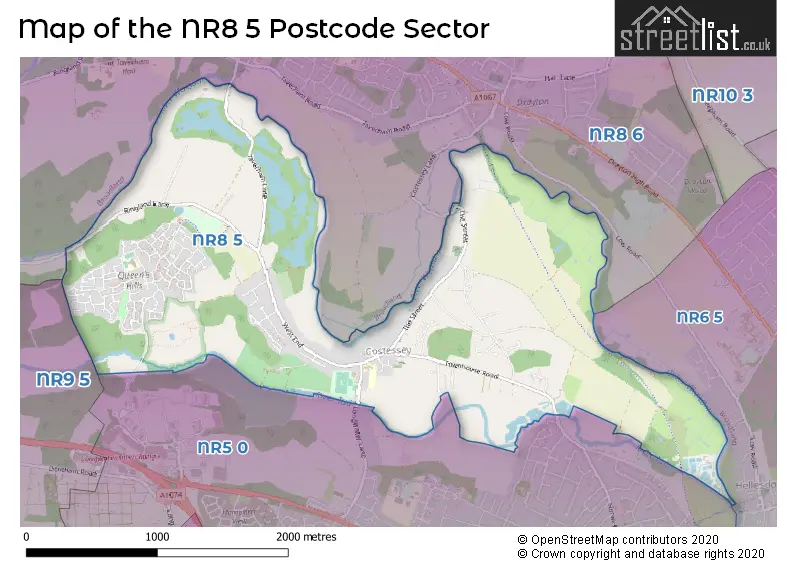
The NR8 5 Postcode shares a border with NR8 6 (Taverham, Drayton, Ringland), NR9 5 (Easton, Lyng, Great Witchingham), NR6 5 (NORWICH, Hellesdon) and NR5 0 (NORWICH, New Costessey).
The sector is within the post town of NORWICH.
NR8 5 is a postcode sector within the NR8 postcode district which is within the NR Norwich postcode area.
The Royal Mail delivery office for the NR8 5 postal sector is the Bowthorpe Delivery Office.
The area of the NR8 5 postcode sector is 2.69 square miles which is 6.96 square kilometres or 1,719.87 square acres.
Waterways within the NR8 5 postcode sector include the River Wensum.

Map of the NR8 5 Postcode Sector
Explore the NR8 5 postcode sector by using our free interactive map.
| N | R | 8 | - | 5 | X | X |
| N | R | 8 | Space | 5 | Letter | Letter |
Official List of Streets
Costessey (94 Streets)
Unofficial Streets or Alternative Spellings
Weather Forecast for NR8 5
Press Button to Show Forecast for Norwich Youth Hostel
| Time Period | Icon | Description | Temperature | Rain Probability | Wind |
|---|---|---|---|---|---|
| 21:00 to 00:00 | Clear night | 6.0°C (feels like 5.0°C) | 1.00% | NE 4 mph |
Press Button to Show Forecast for Norwich Youth Hostel
| Time Period | Icon | Description | Temperature | Rain Probability | Wind |
|---|---|---|---|---|---|
| 00:00 to 03:00 | Partly cloudy (night) | 6.0°C (feels like 4.0°C) | 1.00% | ENE 4 mph | |
| 03:00 to 06:00 | Cloudy | 6.0°C (feels like 4.0°C) | 8.00% | NE 4 mph | |
| 06:00 to 09:00 | Overcast | 7.0°C (feels like 5.0°C) | 53.00% | NE 7 mph | |
| 09:00 to 12:00 | Light rain | 8.0°C (feels like 5.0°C) | 53.00% | ENE 9 mph | |
| 12:00 to 15:00 | Light rain | 9.0°C (feels like 6.0°C) | 50.00% | ENE 11 mph | |
| 15:00 to 18:00 | Overcast | 10.0°C (feels like 7.0°C) | 13.00% | NE 11 mph | |
| 18:00 to 21:00 | Overcast | 9.0°C (feels like 7.0°C) | 11.00% | NE 9 mph | |
| 21:00 to 00:00 | Overcast | 9.0°C (feels like 6.0°C) | 50.00% | NE 9 mph |
Press Button to Show Forecast for Norwich Youth Hostel
| Time Period | Icon | Description | Temperature | Rain Probability | Wind |
|---|---|---|---|---|---|
| 00:00 to 03:00 | Heavy rain | 9.0°C (feels like 6.0°C) | 86.00% | NE 9 mph | |
| 03:00 to 06:00 | Heavy rain | 9.0°C (feels like 7.0°C) | 90.00% | NE 9 mph | |
| 06:00 to 09:00 | Heavy rain | 10.0°C (feels like 8.0°C) | 87.00% | ENE 9 mph | |
| 09:00 to 12:00 | Heavy rain shower (day) | 11.0°C (feels like 8.0°C) | 66.00% | SW 13 mph | |
| 12:00 to 15:00 | Heavy rain shower (day) | 11.0°C (feels like 8.0°C) | 64.00% | W 13 mph | |
| 15:00 to 18:00 | Light rain shower (day) | 10.0°C (feels like 8.0°C) | 45.00% | W 13 mph | |
| 18:00 to 21:00 | Cloudy | 10.0°C (feels like 8.0°C) | 16.00% | WSW 9 mph | |
| 21:00 to 00:00 | Partly cloudy (night) | 8.0°C (feels like 6.0°C) | 4.00% | SW 7 mph |
Press Button to Show Forecast for Norwich Youth Hostel
| Time Period | Icon | Description | Temperature | Rain Probability | Wind |
|---|---|---|---|---|---|
| 00:00 to 03:00 | Cloudy | 7.0°C (feels like 5.0°C) | 6.00% | SW 7 mph | |
| 03:00 to 06:00 | Clear night | 6.0°C (feels like 4.0°C) | 2.00% | SSW 7 mph | |
| 06:00 to 09:00 | Sunny day | 7.0°C (feels like 4.0°C) | 1.00% | S 7 mph | |
| 09:00 to 12:00 | Sunny day | 12.0°C (feels like 10.0°C) | 1.00% | S 9 mph | |
| 12:00 to 15:00 | Cloudy | 14.0°C (feels like 12.0°C) | 9.00% | S 11 mph | |
| 15:00 to 18:00 | Partly cloudy (day) | 14.0°C (feels like 12.0°C) | 4.00% | S 11 mph | |
| 18:00 to 21:00 | Sunny day | 13.0°C (feels like 11.0°C) | 1.00% | SSE 9 mph | |
| 21:00 to 00:00 | Clear night | 9.0°C (feels like 8.0°C) | 1.00% | SE 7 mph |
Press Button to Show Forecast for Norwich Youth Hostel
| Time Period | Icon | Description | Temperature | Rain Probability | Wind |
|---|---|---|---|---|---|
| 00:00 to 03:00 | Partly cloudy (night) | 8.0°C (feels like 6.0°C) | 3.00% | SE 7 mph | |
| 03:00 to 06:00 | Partly cloudy (night) | 7.0°C (feels like 6.0°C) | 4.00% | ESE 7 mph | |
| 06:00 to 09:00 | Cloudy | 10.0°C (feels like 8.0°C) | 9.00% | E 7 mph | |
| 09:00 to 12:00 | Cloudy | 13.0°C (feels like 12.0°C) | 11.00% | ESE 7 mph | |
| 12:00 to 15:00 | Cloudy | 15.0°C (feels like 14.0°C) | 11.00% | SE 9 mph | |
| 15:00 to 18:00 | Cloudy | 16.0°C (feels like 14.0°C) | 8.00% | SE 9 mph | |
| 18:00 to 21:00 | Cloudy | 14.0°C (feels like 13.0°C) | 7.00% | ESE 9 mph | |
| 21:00 to 00:00 | Cloudy | 12.0°C (feels like 11.0°C) | 12.00% | E 7 mph |
Schools and Places of Education Within the NR8 5 Postcode Sector
Queen's Hill Primary School
Community school
Kestrel Avenue, Norwich, Norfolk, NR8 5FT
Head: Mr Matthew Cross
Ofsted Rating: Good
Inspection: 2023-03-29 (394 days ago)
Website: Visit Queen's Hill Primary School Website
Phone: 01603746857
Number of Pupils: 590
St Augustine's Catholic Primary School, Costessey
Academy converter
Westend, Norwich, Norfolk, NR8 5AG
Head: Miss Rachel Swindell
Ofsted Rating: Good
Inspection: 2019-02-12 (1900 days ago)
Website: Visit St Augustine's Catholic Primary School, Costessey Website
Phone: 01603743317
Number of Pupils: 337
House Prices in the NR8 5 Postcode Sector
| Type of Property | 2018 Average | 2018 Sales | 2017 Average | 2017 Sales | 2016 Average | 2016 Sales | 2015 Average | 2015 Sales |
|---|---|---|---|---|---|---|---|---|
| Detached | £304,111 | 88 | £288,429 | 88 | £287,176 | 82 | £257,087 | 90 |
| Semi-Detached | £221,073 | 67 | £220,346 | 64 | £206,380 | 55 | £189,738 | 60 |
| Terraced | £208,556 | 73 | £193,144 | 69 | £191,416 | 98 | £176,561 | 69 |
| Flats | £137,963 | 64 | £134,170 | 51 | £135,662 | 52 | £126,758 | 45 |
Important Postcodes NR8 5 in the Postcode Sector
NR8 5AG is the postcode for St. Augustine's Catholic Primary School, 19 West End, Costessey, and St. Augustine's Catholic Primary School, 19 West End
NR8 5AZ is the postcode for Queens Hill Primary School, Fieldfare Way
NR8 5FT is the postcode for Queens Hill Primary School, Kestrel Avenue, and Queen's Hill Primary & Nursery School, Kestrel Avenue, Costessey
| The NR8 5 Sector is within these Local Authorities |
|
|---|---|
| The NR8 5 Sector is within these Counties |
|
| The NR8 5 Sector is within these Water Company Areas |
|