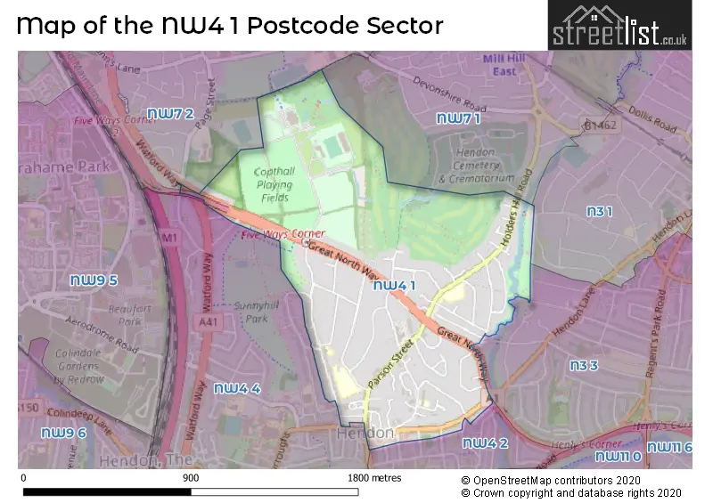
The NW4 1 postcode sector is within the county of Greater London.
Did you know? According to the 2021 Census, the NW4 1 postcode sector is home to a bustling 7,307 residents!
Given that each sector allows for 400 unique postcode combinations. Letters C, I, K, M, O and V are not allowed in the last two letters of a postcode. With 174 postcodes already in use, this leaves 226 units available.
The largest settlements in the NW4 1 postal code are HENDON and CHURCH END .
The NW4 1 Postcode shares a border with N3 1 (FINCHLEY , REGENT CLOSE TO DOLLIS ROAD , CHURCH END ), N3 3 (FINCHLEY , CHURCH END , EAST FINCHLEY ), NW4 2 (HENDON ), NW4 4 (HENDON ), NW7 1 (MILL HILL , CHURCH END ) and NW7 2 (MILL HILL , THE HALE , MILL HILL SOUTH SECTION ).
The sector is within the post town of LONDON.
NW4 1 is a postcode sector within the NW4 postcode district which is within the NW North West London postcode area.
The Royal Mail delivery office for the NW4 1 postal sector is the Hendon Sdelivery Office.
The area of the NW4 1 postcode sector is 0.73 square miles which is 1.90 square kilometres or 468.27 square acres.
The NW4 1 postcode sector is crossed by the A1 Major A road.
The NW4 1 postcode sector is crossed by the M1 motorway.
Waterways within the NW4 1 postcode sector include the Dollis Brook.

Map of the NW4 1 Postcode Sector
Explore the NW4 1 postcode sector by using our free interactive map.
| N | W | 4 | - | 1 | X | X |
| N | W | 4 | Space | 1 | Letter | Letter |
Official List of Streets
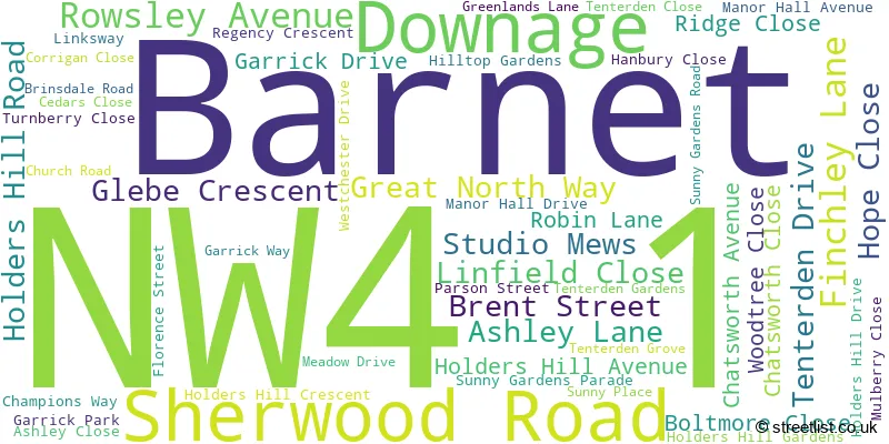
Barnet (52 Streets)
Unofficial Streets or Alternative Spellings
Barnet
ALEXANDRA ROAD APREY GARDENS FIRST AVENUE FULLER STREET HALL LANE HENDON LANE HILLVIEW GARDENS SECOND AVENUE SUNNINGFIELDS CRESCENT WATFORD WAY WAVERLEY GROVE WESTSIDEWeather Forecast for NW4 1
Press Button to Show Forecast for Hampstead Heath Youth Hostel
| Time Period | Icon | Description | Temperature | Rain Probability | Wind |
|---|---|---|---|---|---|
| 21:00 to 00:00 | Cloudy | 8.0°C (feels like 6.0°C) | 7.00% | E 9 mph |
Press Button to Show Forecast for Hampstead Heath Youth Hostel
| Time Period | Icon | Description | Temperature | Rain Probability | Wind |
|---|---|---|---|---|---|
| 00:00 to 03:00 | Cloudy | 7.0°C (feels like 4.0°C) | 52.00% | ENE 9 mph | |
| 03:00 to 06:00 | Light rain | 6.0°C (feels like 3.0°C) | 56.00% | ENE 9 mph | |
| 06:00 to 09:00 | Light rain | 6.0°C (feels like 3.0°C) | 61.00% | NE 9 mph | |
| 09:00 to 12:00 | Overcast | 7.0°C (feels like 4.0°C) | 45.00% | NE 11 mph | |
| 12:00 to 15:00 | Overcast | 10.0°C (feels like 8.0°C) | 12.00% | ENE 9 mph | |
| 15:00 to 18:00 | Cloudy | 12.0°C (feels like 10.0°C) | 9.00% | NE 9 mph | |
| 18:00 to 21:00 | Light rain | 10.0°C (feels like 8.0°C) | 59.00% | NE 11 mph | |
| 21:00 to 00:00 | Heavy rain | 9.0°C (feels like 6.0°C) | 89.00% | NE 11 mph |
Press Button to Show Forecast for Hampstead Heath Youth Hostel
| Time Period | Icon | Description | Temperature | Rain Probability | Wind |
|---|---|---|---|---|---|
| 00:00 to 03:00 | Heavy rain | 8.0°C (feels like 5.0°C) | 92.00% | NNE 11 mph | |
| 03:00 to 06:00 | Heavy rain | 8.0°C (feels like 6.0°C) | 92.00% | NE 9 mph | |
| 06:00 to 09:00 | Heavy rain | 8.0°C (feels like 6.0°C) | 85.00% | NNW 9 mph | |
| 09:00 to 12:00 | Heavy rain | 8.0°C (feels like 6.0°C) | 84.00% | WNW 9 mph | |
| 12:00 to 15:00 | Light rain | 9.0°C (feels like 6.0°C) | 56.00% | W 13 mph | |
| 15:00 to 18:00 | Overcast | 10.0°C (feels like 7.0°C) | 16.00% | W 11 mph | |
| 18:00 to 21:00 | Cloudy | 10.0°C (feels like 8.0°C) | 8.00% | W 9 mph | |
| 21:00 to 00:00 | Partly cloudy (night) | 9.0°C (feels like 7.0°C) | 4.00% | SW 7 mph |
Press Button to Show Forecast for Hampstead Heath Youth Hostel
| Time Period | Icon | Description | Temperature | Rain Probability | Wind |
|---|---|---|---|---|---|
| 00:00 to 03:00 | Clear night | 7.0°C (feels like 6.0°C) | 2.00% | SW 4 mph | |
| 03:00 to 06:00 | Clear night | 6.0°C (feels like 4.0°C) | 1.00% | SSW 4 mph | |
| 06:00 to 09:00 | Sunny day | 6.0°C (feels like 5.0°C) | 1.00% | S 4 mph | |
| 09:00 to 12:00 | Partly cloudy (day) | 11.0°C (feels like 9.0°C) | 2.00% | S 9 mph | |
| 12:00 to 15:00 | Cloudy | 14.0°C (feels like 12.0°C) | 4.00% | S 11 mph | |
| 15:00 to 18:00 | Partly cloudy (day) | 15.0°C (feels like 12.0°C) | 2.00% | S 11 mph | |
| 18:00 to 21:00 | Sunny day | 13.0°C (feels like 12.0°C) | 3.00% | S 9 mph | |
| 21:00 to 00:00 | Clear night | 11.0°C (feels like 9.0°C) | 1.00% | SSE 7 mph |
Press Button to Show Forecast for Hampstead Heath Youth Hostel
| Time Period | Icon | Description | Temperature | Rain Probability | Wind |
|---|---|---|---|---|---|
| 00:00 to 03:00 | Clear night | 9.0°C (feels like 8.0°C) | 1.00% | SE 7 mph | |
| 03:00 to 06:00 | Clear night | 8.0°C (feels like 7.0°C) | 2.00% | ESE 7 mph | |
| 06:00 to 09:00 | Partly cloudy (day) | 9.0°C (feels like 7.0°C) | 4.00% | ESE 7 mph | |
| 09:00 to 12:00 | Cloudy | 12.0°C (feels like 11.0°C) | 6.00% | ESE 7 mph | |
| 12:00 to 15:00 | Cloudy | 15.0°C (feels like 14.0°C) | 8.00% | SE 9 mph | |
| 15:00 to 18:00 | Cloudy | 16.0°C (feels like 14.0°C) | 10.00% | SE 9 mph | |
| 18:00 to 21:00 | Cloudy | 15.0°C (feels like 14.0°C) | 11.00% | SE 9 mph | |
| 21:00 to 00:00 | Cloudy | 13.0°C (feels like 11.0°C) | 10.00% | ESE 7 mph |
Schools and Places of Education Within the NW4 1 Postcode Sector
Hasmonean High School for Boys
Academy converter
Holders Hill Road, London, , NW4 1NA
Head: Mrs Miriam Langdon
Ofsted Rating: Good
Inspection: 2023-11-08 (170 days ago)
Website: Visit Hasmonean High School for Boys Website
Phone: 02082031411
Number of Pupils: 726
Kisharon School
Free schools special
54 Parson Street, London, , NW4 1TP
Head: Dr Emily Haddock
Ofsted Rating: Good
Inspection: 2023-01-18 (464 days ago)
Website: Visit Kisharon School Website
Phone: 02084557483
Number of Pupils: 70
House Prices in the NW4 1 Postcode Sector
| Type of Property | 2018 Average | 2018 Sales | 2017 Average | 2017 Sales | 2016 Average | 2016 Sales | 2015 Average | 2015 Sales |
|---|---|---|---|---|---|---|---|---|
| Detached | £1,447,583 | 9 | £1,882,857 | 7 | £1,534,231 | 13 | £1,627,083 | 12 |
| Semi-Detached | £839,672 | 19 | £800,060 | 25 | £704,713 | 19 | £673,656 | 16 |
| Terraced | £494,500 | 4 | £606,000 | 10 | £585,333 | 6 | £580,533 | 6 |
| Flats | £482,490 | 55 | £501,275 | 75 | £481,901 | 100 | £415,522 | 83 |
Important Postcodes NW4 1 in the Postcode Sector
NW4 1AB is the postcode for ST MARYS AND ST JOHNS C OF E SCHOOL, DOWNAGE, HENDON, and St. Marys C of E High School, Downage
NW4 1DP is the postcode for Department for Work and Pensions, Crown Building, 10 Finchley Lane, Crown Building, 10 Finchley Lane, and Benefits Agency, Crown Building, 10 Finchley Lane
NW4 1NA is the postcode for MAIN BLOCK, Hasmonean Boys High School, Holders Hill Road, and ARTS BLOCK, Hasmonean Boys High School, Holders Hill Road
NW4 1PX is the postcode for Barnet Copthall (New) Leisure Centre, Champions Way, and Barnet Copthall Leisure Centre, Champions Way
NW4 1RP is the postcode for Hendon Hospital, 46-50 Sunny Gardens Road
| The NW4 1 Sector is within these Local Authorities |
|
|---|---|
| The NW4 1 Sector is within these Counties |
|
| The NW4 1 Sector is within these Water Company Areas |
|