The NW5 2 postcode sector is within the county of Greater London.
Did you know? According to the 2021 Census, the NW5 2 postcode sector is home to a bustling 9,450 residents!
Given that each sector allows for 400 unique postcode combinations. Letters C, I, K, M, O and V are not allowed in the last two letters of a postcode. With 201 postcodes already in use, this leaves 199 units available.
The NW5 2 postal code covers the settlement of LONDON .
The NW5 2 Postcode shares a border with N7 0 (ISLINGTON , LONDON ), N19 5 (ISLINGTON , LONDON ), NW5 3 (LONDON ), NW1 9 (LONDON ), NW5 1 (LONDON , ISLINGTON ) and NW5 4 (LONDON ).
The sector is within the post town of LONDON.
NW5 2 is a postcode sector within the NW5 postcode district which is within the NW North West London postcode area.
The Royal Mail delivery office for the NW5 2 postal sector is the Kentish Town Sdelivery Office.
The area of the NW5 2 postcode sector is 0.24 square miles which is 0.63 square kilometres or 155.83 square acres.

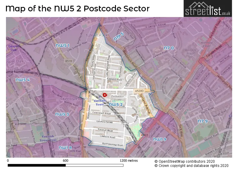
Map of the NW5 2 Postcode Sector
Explore the NW5 2 postcode sector by using our free interactive map.
| N | W | 5 | - | 2 | X | X |
| N | W | 5 | Space | 2 | Letter | Letter |
Official List of Streets
Camden (49 Streets)
Unofficial Streets or Alternative Spellings
Weather Forecast for NW5 2
Press Button to Show Forecast for Camden Town
| Time Period | Icon | Description | Temperature | Rain Probability | Wind |
|---|---|---|---|---|---|
| 06:00 to 09:00 | Cloudy | 5.0°C (feels like 3.0°C) | 4.00% | NE 7 mph | |
| 09:00 to 12:00 | Cloudy | 8.0°C (feels like 6.0°C) | 4.00% | ENE 7 mph | |
| 12:00 to 15:00 | Cloudy | 10.0°C (feels like 9.0°C) | 10.00% | ENE 7 mph | |
| 15:00 to 18:00 | Cloudy | 11.0°C (feels like 10.0°C) | 12.00% | ENE 7 mph | |
| 18:00 to 21:00 | Cloudy | 10.0°C (feels like 9.0°C) | 13.00% | NE 7 mph | |
| 21:00 to 00:00 | Cloudy | 8.0°C (feels like 5.0°C) | 11.00% | E 7 mph |
Press Button to Show Forecast for Camden Town
| Time Period | Icon | Description | Temperature | Rain Probability | Wind |
|---|---|---|---|---|---|
| 00:00 to 03:00 | Cloudy | 6.0°C (feels like 4.0°C) | 17.00% | ENE 7 mph | |
| 03:00 to 06:00 | Cloudy | 5.0°C (feels like 3.0°C) | 18.00% | NE 7 mph | |
| 06:00 to 09:00 | Overcast | 6.0°C (feels like 3.0°C) | 24.00% | NE 7 mph | |
| 09:00 to 12:00 | Cloudy | 10.0°C (feels like 7.0°C) | 15.00% | ENE 9 mph | |
| 12:00 to 15:00 | Overcast | 12.0°C (feels like 10.0°C) | 17.00% | E 9 mph | |
| 15:00 to 18:00 | Light rain | 13.0°C (feels like 10.0°C) | 52.00% | E 11 mph | |
| 18:00 to 21:00 | Light rain | 11.0°C (feels like 9.0°C) | 54.00% | ENE 9 mph | |
| 21:00 to 00:00 | Light rain | 10.0°C (feels like 7.0°C) | 54.00% | NE 11 mph |
Press Button to Show Forecast for Camden Town
| Time Period | Icon | Description | Temperature | Rain Probability | Wind |
|---|---|---|---|---|---|
| 00:00 to 03:00 | Heavy rain | 9.0°C (feels like 7.0°C) | 75.00% | NE 9 mph | |
| 03:00 to 06:00 | Light rain shower (night) | 10.0°C (feels like 8.0°C) | 45.00% | ESE 9 mph | |
| 06:00 to 09:00 | Light rain | 10.0°C (feels like 8.0°C) | 52.00% | SE 7 mph | |
| 09:00 to 12:00 | Heavy rain shower (day) | 11.0°C (feels like 9.0°C) | 61.00% | SE 9 mph | |
| 12:00 to 15:00 | Heavy rain shower (day) | 12.0°C (feels like 10.0°C) | 61.00% | S 9 mph | |
| 15:00 to 18:00 | Light rain shower (day) | 14.0°C (feels like 12.0°C) | 37.00% | SSW 11 mph | |
| 18:00 to 21:00 | Partly cloudy (day) | 12.0°C (feels like 10.0°C) | 15.00% | SW 11 mph | |
| 21:00 to 00:00 | Partly cloudy (night) | 10.0°C (feels like 9.0°C) | 8.00% | SW 7 mph |
Schools and Places of Education Within the NW5 2 Postcode Sector
Eleanor Palmer Primary School
Community school
Lupton Street, London, , NW5 2JA
Head: Ms Sally Hill and Natalie Stevenson
Ofsted Rating: Outstanding
Inspection: 2023-09-14 (225 days ago)
Website: Visit Eleanor Palmer Primary School Website
Phone: 02074852155
Number of Pupils: 236
Kentish Town Church of England Primary School
Voluntary aided school
Islip Street, London, , NW5 2TU
Head: Mr James Vincent Humphries
Ofsted Rating: Outstanding
Inspection: 2017-12-08 (2331 days ago)
Website: Visit Kentish Town Church of England Primary School Website
Phone: 02074851279
Number of Pupils: 234
The Camden School for Girls
Voluntary aided school
Sandall Road, London, , NW5 2DB
Head: Mrs Kateryna Law
Ofsted Rating: Good
Inspection: 2022-06-09 (687 days ago)
Website: Visit The Camden School for Girls Website
Phone: 02074853414
Number of Pupils: 1047
Torriano Primary School
Community school
Torriano Avenue, London, , NW5 2SJ
Head: Ms Helen Bruckdorfer
Ofsted Rating: Outstanding
Inspection: 2018-09-19 (2046 days ago)
Website: Visit Torriano Primary School Website
Phone: 02074240202
Number of Pupils: 450
House Prices in the NW5 2 Postcode Sector
| Type of Property | 2018 Average | 2018 Sales | 2017 Average | 2017 Sales | 2016 Average | 2016 Sales | 2015 Average | 2015 Sales |
|---|---|---|---|---|---|---|---|---|
| Detached | £0 | 0 | £0 | 0 | £0 | 0 | £830,000 | 1 |
| Semi-Detached | £1,647,000 | 3 | £1,783,750 | 4 | £2,058,333 | 3 | £1,775,000 | 2 |
| Terraced | £1,470,651 | 12 | £1,417,083 | 12 | £1,369,900 | 14 | £1,302,480 | 25 |
| Flats | £593,905 | 55 | £597,517 | 86 | £662,843 | 59 | £561,237 | 75 |
Important Postcodes NW5 2 in the Postcode Sector
NW5 2AA is the postcode for London Borough of Camden, Kentish Town Library, 262-266 Kentish Town Road
NW5 2AG is the postcode for Department for Work and Pensions, 174-178 Kentish Town Road, and 174-178 Kentish Town Road
NW5 2AJ is the postcode for Kentish Town Health Centre, 2 Bartholomew Road
NW5 2BX is the postcode for James Wigg Practice, Kentish Town Health Centre, 2 Bartholomew Road
NW5 2DB is the postcode for 6TH FORM HOUSE, Camden School for Girls, Sandall Road, CAMDEN BUILDING, Camden School for Girls, Sandall Road, MAIN BUILDING, Camden School for Girls, Sandall Road, and Camden School for Girls, Sandall Road
NW5 2DR is the postcode for Vadnie Bish House, 33-43 Caversham Road, and CAVERSHAM CHILDREN'S CENTRE, Vadnie Bish House, 33-43 Caversham Road
NW5 2JA is the postcode for Eleanor Palmer Primary School, Lupton Street
NW5 2QL is the postcode for 7, Leighton Place
NW5 2SJ is the postcode for Torriano Junior School, Torriano Avenue, and Torriano Infant School, Torriano Avenue
NW5 2TU is the postcode for Kentish Town Primary School, Islip Street
NW5 2TX is the postcode for The Peckwater Centre, 6 Peckwater Street
NW5 2UP is the postcode for Peckwater Centre, 6 Peckwater Street, and CAVERSHAM PRACTICE, 4 PECKWATER STREET, KENTISH TOWN
| The NW5 2 Sector is within these Local Authorities |
|
|---|---|
| The NW5 2 Sector is within these Counties |
|
| The NW5 2 Sector is within these Water Company Areas |
|