The NW8 postcode district is a postal district located in the NW London - NW postcode area with a population of 32,802 residents according to the 2021 England and Wales Census.
The area of the NW8 postcode district is 1.04 square miles which is 2.69 square kilometres or 664.94 acres.
Currently, the NW8 district has about 841 postcode units spread across 5 geographic postcode sectors.
Given that each sector allows for 400 unique postcode combinations, the district has a capacity of 2,000 postcodes. With 841 postcodes already in use, this leaves 1159 units available.
The NW8 postal code covers the settlement of LONDON.
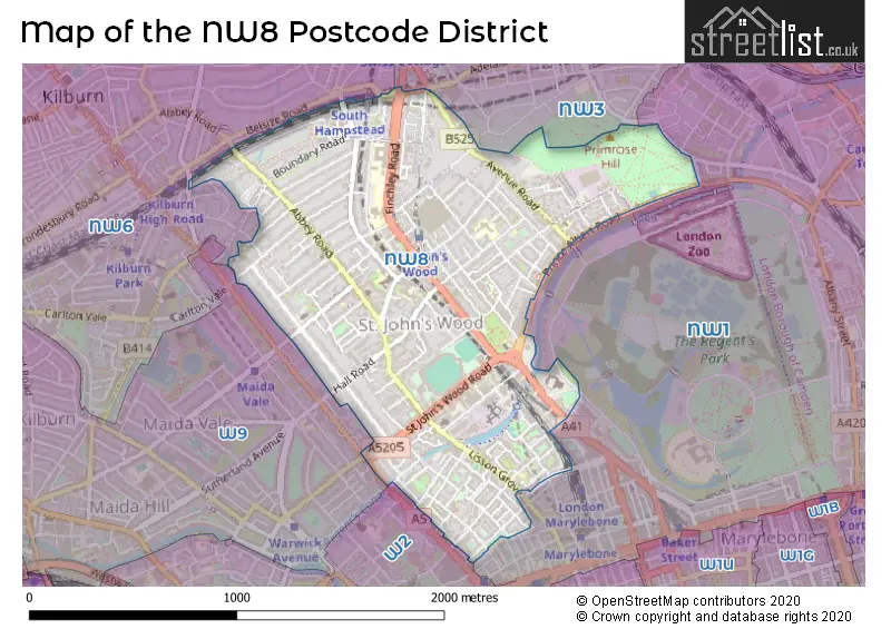
The NW8 Postcode shares a border with NW3 (LONDON), NW6 (LONDON), NW1 (LONDON) and W2 (LONDON).
In the NW8 postcode district, the primary settlement is Westminster, which is located in Greater London, England. Other significant settlements in the district include Camden and Brent, also located in Greater London. The most significant post town in the district is London.
For the district NW8, we have data on 6 postcode sectors. Here's a breakdown: The sector NW8 0, covers Westminster and Camden in Greater London. The sector NW8 1 is non-geographic. It's often designated for PO Boxes, large organisations, or special services. The sector NW8 6, covers Westminster and Camden in Greater London. The sector NW8 7, covers Westminster in Greater London. The sector NW8 8, covers Westminster in Greater London. The sector NW8 9, covers Westminster in Greater London.

Map of the NW8 Postcode District
Explore the NW8 postcode district by using our free interactive map.
When it comes to local government, postal geography often disregards political borders. However, for a breakdown in the NW8 District: the district mostly encompasses the City of Westminster London Boro (716 postcodes), followed by the Camden London Boro area (107 postcodes), and finally, the Brent London Boro area (28 postcodes).
Recent House Sales in NW8
| Date | Price | Address |
|---|---|---|
| 16/10/2023 | £375,000 | Salisbury Street, London, NW8 8QA |
| 27/09/2023 | £384,714 | Park Road, London, NW8 7JH |
| 01/09/2023 | £325,000 | Grove End Road, London, NW8 9EH |
| 31/08/2023 | £915,000 | St John's Wood Park, London, NW8 6RL |
| 30/08/2023 | £11,000,000 | Eyre Road, London, NW8 9BQ |
| 25/08/2023 | £861,800 | Acacia Road, London, NW8 6BJ |
| 25/08/2023 | £420,000 | Boldero Place, London, NW8 8EQ |
| 25/08/2023 | £410,000 | Boldero Place, London, NW8 8EQ |
| 25/08/2023 | £5,350,000 | Clifton Hill, St Johns Wood, London, NW8 0QE |
| 23/08/2023 | £725,000 | Wellington Road, St Johns Wood, London, NW8 9TD |
Where is the NW8 Postcode District?
The postcode district NW8 is located in London. It is specifically in the LONDON district. This area is nearby several towns including Regents Park, Little Venice, Maida Hill, and Marylebone. The distance between NW8 and the center of London is approximately 2.67 miles.
The district is within the post town of LONDON.
The sector has postcodes within the nation of England.
The NW8 Postcode District is covers the following regions.
- Westminster - Inner London - West - London
- Camden and City of London - Inner London - West - London
- Brent - Outer London - West and North West - London
Weather Forecast for NW8
Press Button to Show Forecast for Lord's Marylebone C.C.
| Time Period | Icon | Description | Temperature | Rain Probability | Wind |
|---|---|---|---|---|---|
| 00:00 to 03:00 | Partly cloudy (night) | 15.0°C (feels like 14.0°C) | 1.00% | ENE 9 mph | |
| 03:00 to 06:00 | Cloudy | 15.0°C (feels like 14.0°C) | 4.00% | ENE 7 mph | |
| 06:00 to 09:00 | Cloudy | 15.0°C (feels like 14.0°C) | 4.00% | ENE 7 mph | |
| 09:00 to 12:00 | Cloudy | 19.0°C (feels like 18.0°C) | 3.00% | E 7 mph | |
| 12:00 to 15:00 | Partly cloudy (day) | 24.0°C (feels like 22.0°C) | 2.00% | ESE 9 mph | |
| 15:00 to 18:00 | Cloudy | 25.0°C (feels like 23.0°C) | 7.00% | SE 9 mph | |
| 18:00 to 21:00 | Cloudy | 23.0°C (feels like 21.0°C) | 7.00% | SSE 7 mph | |
| 21:00 to 00:00 | Cloudy | 18.0°C (feels like 17.0°C) | 9.00% | SSW 7 mph |
Press Button to Show Forecast for Lord's Marylebone C.C.
| Time Period | Icon | Description | Temperature | Rain Probability | Wind |
|---|---|---|---|---|---|
| 00:00 to 03:00 | Cloudy | 15.0°C (feels like 15.0°C) | 16.00% | SSW 7 mph | |
| 03:00 to 06:00 | Partly cloudy (night) | 14.0°C (feels like 13.0°C) | 7.00% | S 7 mph | |
| 06:00 to 09:00 | Overcast | 13.0°C (feels like 12.0°C) | 12.00% | SSW 9 mph | |
| 09:00 to 12:00 | Overcast | 16.0°C (feels like 14.0°C) | 12.00% | SSW 11 mph | |
| 12:00 to 15:00 | Cloudy | 17.0°C (feels like 15.0°C) | 10.00% | S 13 mph | |
| 15:00 to 18:00 | Cloudy | 18.0°C (feels like 15.0°C) | 17.00% | S 13 mph | |
| 18:00 to 21:00 | Light rain | 17.0°C (feels like 14.0°C) | 54.00% | SSE 11 mph | |
| 21:00 to 00:00 | Heavy rain | 15.0°C (feels like 13.0°C) | 80.00% | SSE 11 mph |
Press Button to Show Forecast for Lord's Marylebone C.C.
| Time Period | Icon | Description | Temperature | Rain Probability | Wind |
|---|---|---|---|---|---|
| 00:00 to 03:00 | Heavy rain | 14.0°C (feels like 13.0°C) | 78.00% | SSE 9 mph | |
| 03:00 to 06:00 | Heavy rain | 14.0°C (feels like 13.0°C) | 76.00% | SSE 7 mph | |
| 06:00 to 09:00 | Light rain | 13.0°C (feels like 12.0°C) | 58.00% | SSE 7 mph | |
| 09:00 to 12:00 | Light rain | 15.0°C (feels like 13.0°C) | 56.00% | S 11 mph | |
| 12:00 to 15:00 | Light rain shower (day) | 16.0°C (feels like 14.0°C) | 39.00% | S 13 mph | |
| 15:00 to 18:00 | Light rain shower (day) | 17.0°C (feels like 14.0°C) | 33.00% | S 13 mph | |
| 18:00 to 21:00 | Partly cloudy (day) | 16.0°C (feels like 14.0°C) | 11.00% | S 11 mph | |
| 21:00 to 00:00 | Clear night | 14.0°C (feels like 12.0°C) | 9.00% | SSE 9 mph |
Press Button to Show Forecast for Lord's Marylebone C.C.
| Time Period | Icon | Description | Temperature | Rain Probability | Wind |
|---|---|---|---|---|---|
| 00:00 to 03:00 | Partly cloudy (night) | 13.0°C (feels like 11.0°C) | 5.00% | S 9 mph | |
| 03:00 to 06:00 | Cloudy | 12.0°C (feels like 11.0°C) | 7.00% | S 7 mph | |
| 06:00 to 09:00 | Partly cloudy (day) | 12.0°C (feels like 11.0°C) | 6.00% | S 9 mph | |
| 09:00 to 12:00 | Partly cloudy (day) | 14.0°C (feels like 12.0°C) | 9.00% | S 11 mph | |
| 12:00 to 15:00 | Light rain shower (day) | 16.0°C (feels like 14.0°C) | 32.00% | S 13 mph | |
| 15:00 to 18:00 | Partly cloudy (day) | 17.0°C (feels like 14.0°C) | 7.00% | S 11 mph | |
| 18:00 to 21:00 | Sunny day | 17.0°C (feels like 14.0°C) | 8.00% | S 9 mph | |
| 21:00 to 00:00 | Clear night | 14.0°C (feels like 13.0°C) | 6.00% | S 7 mph |
| Postcode Sector | Delivery Office |
|---|---|
| NW8 0 | St Johns Wood Sdelivery Office |
| NW8 6 | St Johns Wood Sdelivery Office |
| NW8 7 | St Johns Wood Sdelivery Office |
| NW8 8 | St Johns Wood Sdelivery Office |
| NW8 9 | St Johns Wood Sdelivery Office |
| N | W | 8 | - | X | X | X |
| N | W | 8 | Space | Numeric | Letter | Letter |
Tourist Attractions within the NW8 Postcode Area
We found 1 visitor attractions within the NW8 postcode area
| Ben Uri Art Gallery, London Jewish Museum of Art |
|---|
| Museums & Art Galleries |
| Museum and / or Art Gallery |
| View Ben Uri Art Gallery, London Jewish Museum of Art on Google Maps |
Current Monthly Rental Prices
| # Bedrooms | Min Price | Max Price | Avg Price |
|---|---|---|---|
| £415 | £7,800 | £1,930 | |
| 1 | £1,550 | £5,200 | £2,675 |
| 2 | £2,383 | £15,000 | £4,087 |
| 3 | £2,999 | £21,667 | £5,852 |
| 4 | £2,750 | £41,167 | £9,242 |
| 5 | £7,475 | £108,333 | £12,591 |
| 6 | £8,168 | £29,467 | £17,705 |
Current House Prices
| # Bedrooms | Min Price | Max Price | Avg Price |
|---|---|---|---|
| £100,000 | £12,500,000 | £985,565 | |
| 1 | £350,000 | £1,275,000 | £609,070 |
| 2 | £425,000 | £3,850,000 | £1,061,043 |
| 3 | £550,000 | £7,995,000 | £2,243,000 |
| 4 | £725,000 | £15,500,000 | £4,083,730 |
| 5 | £2,900,000 | £15,000,000 | £6,247,368 |
| 6 | £2,250,000 | £22,000,000 | £9,617,895 |
| 7 | £7,250,000 | £17,895,000 | £11,369,000 |
| 8 | £11,300,000 | £27,500,000 | £24,210,000 |
| 11 | £3,500,000 | £3,500,000 | £3,500,000 |
Estate Agents who Operate in the NW8 District
| Logo | Name | Brand Name | Address | Contact Number | Total Properties |
|---|---|---|---|---|---|
 | St John's Wood | Winkworth | 103/104 St. Johns Wood Terrace, London, NW8 6PL | 020 3869 0435 | 130 |
 | St Johns Wood | Foxtons | 98 St. Johns Wood Terrace, London, NW8 6PL | 020 3908 8503 | 97 |
 | St John's Wood | Hanover | 102 St. Johns Wood Terrace, London, NW8 6PL | 020 3840 3458 | 57 |
 | St John's Wood & Regent's Park | Savills | 15 St. Johns Wood High Street London NW8 7NG | 020 3840 3927 | 49 |
 | St. Johns Wood | Dexters | 4-6 St. Anns Terrace, London, NW8 6PJ | 020 7483 6330 | 47 |
Yearly House Price Averages for the NW8 Postcode District
| Type of Property | 2018 Average | 2018 Sales | 2017 Average | 2017 Sales | 2016 Average | 2016 Sales | 2015 Average | 2015 Sales |
|---|---|---|---|---|---|---|---|---|
| Detached | £9,040,407 | 10 | £7,527,239 | 6 | £8,931,552 | 12 | £8,059,690 | 10 |
| Semi-Detached | £4,810,385 | 13 | £4,550,922 | 18 | £3,598,100 | 10 | £4,792,500 | 6 |
| Terraced | £3,871,670 | 25 | £4,650,770 | 28 | £3,216,750 | 28 | £2,486,197 | 31 |
| Flats | £1,102,477 | 233 | £1,145,324 | 308 | £1,188,455 | 294 | £1,327,431 | 394 |