The OL9 7 postcode sector is within the county of Greater Manchester.
Did you know? According to the 2021 Census, the OL9 7 postcode sector is home to a bustling 8,208 residents!
Given that each sector allows for 400 unique postcode combinations. Letters C, I, K, M, O and V are not allowed in the last two letters of a postcode. With 176 postcodes already in use, this leaves 224 units available.
The largest settlements in the OL9 7 postal code are OLDHAM and Chadderton.
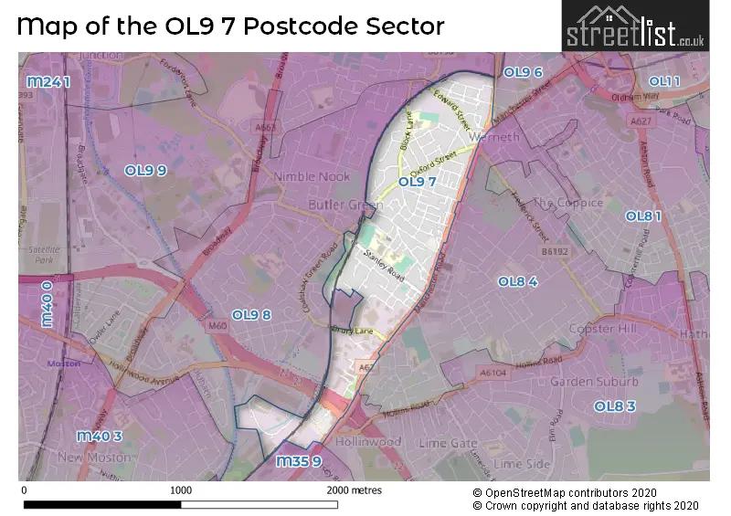
The OL9 7 Postcode shares a border with M35 9 (Failsworth), OL8 3 (OLDHAM), OL8 4 (OLDHAM), OL9 6 (OLDHAM, Chadderton), OL9 8 (Chadderton) and OL9 9 (Chadderton).
The sector is within the post town of OLDHAM.
OL9 7 is a postcode sector within the OL9 postcode district which is within the OL Oldham postcode area.
The Royal Mail delivery office for the OL9 7 postal sector is the Oldham Delivery Office.
The area of the OL9 7 postcode sector is 0.47 square miles which is 1.22 square kilometres or 301.13 square acres.
The OL9 7 postcode sector is crossed by the M60 motorway.
Waterways within the OL9 7 postcode sector include the Rochdale Canal.

Map of the OL9 7 Postcode Sector
Explore the OL9 7 postcode sector by using our free interactive map.
| O | L | 9 | - | 7 | X | X |
| O | L | 9 | Space | 7 | Letter | Letter |
Official List of Streets
Chadderton (46 Streets)
OLDHAM (55 Streets)
Unofficial Streets or Alternative Spellings
OLDHAM
BAXTER STREET FREDERICK STREET GRANGE AVENUE HOLLINS ROAD MANCHESTER STREET NETHERFIELD CLOSE BEXLEY STREET CHARLES STREET CLOCK STREET COLLINS WAY DOVER STREET ELY STREET HADFIELD AVENUE HUDSON STREET MILL LANE NEW PARSONS STREET NEWALL STREET PENNINGTON STREET PRIEST STREET PUMP STREET SEFTON STREET SURREY STREET TAMWORTH COURTChadderton
GOODWIN COURT HOLLINWOOD AVENUE JAMMY LANE ROSE STREET TWEEDALE WAY WASHBROOKHawksley Industrial Estate
MANCHESTER ROADFailsworth
OLDHAM ROADWeather Forecast for OL9 7
Press Button to Show Forecast for Lime Side
| Time Period | Icon | Description | Temperature | Rain Probability | Wind |
|---|---|---|---|---|---|
| 03:00 to 06:00 | Clear night | 4.0°C (feels like 1.0°C) | 1.00% | NE 7 mph | |
| 06:00 to 09:00 | Sunny day | 4.0°C (feels like 1.0°C) | 1.00% | ENE 7 mph | |
| 09:00 to 12:00 | Partly cloudy (day) | 7.0°C (feels like 5.0°C) | 1.00% | ENE 9 mph | |
| 12:00 to 15:00 | Cloudy | 9.0°C (feels like 7.0°C) | 5.00% | ENE 11 mph | |
| 15:00 to 18:00 | Cloudy | 9.0°C (feels like 7.0°C) | 14.00% | ENE 11 mph | |
| 18:00 to 21:00 | Cloudy | 8.0°C (feels like 6.0°C) | 9.00% | ENE 9 mph | |
| 21:00 to 00:00 | Cloudy | 6.0°C (feels like 4.0°C) | 4.00% | NE 9 mph |
Press Button to Show Forecast for Lime Side
| Time Period | Icon | Description | Temperature | Rain Probability | Wind |
|---|---|---|---|---|---|
| 00:00 to 03:00 | Cloudy | 6.0°C (feels like 2.0°C) | 4.00% | NE 9 mph | |
| 03:00 to 06:00 | Cloudy | 5.0°C (feels like 2.0°C) | 5.00% | NNE 9 mph | |
| 06:00 to 09:00 | Cloudy | 5.0°C (feels like 2.0°C) | 47.00% | NNE 9 mph | |
| 09:00 to 12:00 | Light rain | 7.0°C (feels like 4.0°C) | 54.00% | N 9 mph | |
| 12:00 to 15:00 | Overcast | 8.0°C (feels like 6.0°C) | 17.00% | NW 9 mph | |
| 15:00 to 18:00 | Cloudy | 10.0°C (feels like 7.0°C) | 12.00% | WNW 11 mph | |
| 18:00 to 21:00 | Sunny day | 10.0°C (feels like 7.0°C) | 3.00% | W 9 mph | |
| 21:00 to 00:00 | Clear night | 7.0°C (feels like 5.0°C) | 2.00% | SW 4 mph |
Press Button to Show Forecast for Lime Side
| Time Period | Icon | Description | Temperature | Rain Probability | Wind |
|---|---|---|---|---|---|
| 00:00 to 03:00 | Clear night | 6.0°C (feels like 3.0°C) | 1.00% | S 7 mph | |
| 03:00 to 06:00 | Clear night | 4.0°C (feels like 2.0°C) | 2.00% | SSE 7 mph | |
| 06:00 to 09:00 | Partly cloudy (day) | 5.0°C (feels like 3.0°C) | 3.00% | SSE 7 mph | |
| 09:00 to 12:00 | Partly cloudy (day) | 10.0°C (feels like 7.0°C) | 2.00% | S 11 mph | |
| 12:00 to 15:00 | Cloudy | 13.0°C (feels like 10.0°C) | 6.00% | S 13 mph | |
| 15:00 to 18:00 | Overcast | 13.0°C (feels like 10.0°C) | 11.00% | S 13 mph | |
| 18:00 to 21:00 | Partly cloudy (day) | 13.0°C (feels like 10.0°C) | 5.00% | S 11 mph | |
| 21:00 to 00:00 | Clear night | 10.0°C (feels like 8.0°C) | 3.00% | SSE 9 mph |
Press Button to Show Forecast for Lime Side
| Time Period | Icon | Description | Temperature | Rain Probability | Wind |
|---|---|---|---|---|---|
| 00:00 to 03:00 | Clear night | 9.0°C (feels like 7.0°C) | 3.00% | SE 9 mph | |
| 03:00 to 06:00 | Partly cloudy (night) | 8.0°C (feels like 6.0°C) | 2.00% | SE 9 mph | |
| 06:00 to 09:00 | Partly cloudy (day) | 9.0°C (feels like 6.0°C) | 2.00% | ESE 9 mph | |
| 09:00 to 12:00 | Sunny day | 12.0°C (feels like 9.0°C) | 3.00% | ESE 11 mph | |
| 12:00 to 15:00 | Partly cloudy (day) | 15.0°C (feels like 12.0°C) | 4.00% | SE 13 mph | |
| 15:00 to 18:00 | Cloudy | 16.0°C (feels like 13.0°C) | 9.00% | SE 11 mph | |
| 18:00 to 21:00 | Cloudy | 15.0°C (feels like 13.0°C) | 9.00% | ESE 11 mph | |
| 21:00 to 00:00 | Cloudy | 12.0°C (feels like 11.0°C) | 8.00% | E 9 mph |
Schools and Places of Education Within the OL9 7 Postcode Sector
Corpus Christi RC Primary School
Voluntary aided school
Stanley Road, Oldham, Lancashire, OL9 7HA
Head: Mrs Helen Williamson
Ofsted Rating: Outstanding
Inspection: 2023-03-30 (394 days ago)
Website: Visit Corpus Christi RC Primary School Website
Phone: 01616521275
Number of Pupils: 332
Freehold Community Academy
Academy converter
Sidmouth Street, Oldham, Greater Manchester, OL9 7RG
Head: Mrs Nicola Maher
Ofsted Rating: Good
Inspection: 2023-11-01 (178 days ago)
Website: Visit Freehold Community Academy Website
Phone: 01617706450
Number of Pupils: 475
Stanley Road Primary School
Community school
Derby Street, Oldham, Greater Manchester, OL9 7HX
Head: Mrs Rebecca Howarth
Ofsted Rating: Good
Inspection: 2024-01-24 (94 days ago)
Website: Visit Stanley Road Primary School Website
Phone: 01617708383
Number of Pupils: 458
House Prices in the OL9 7 Postcode Sector
| Type of Property | 2018 Average | 2018 Sales | 2017 Average | 2017 Sales | 2016 Average | 2016 Sales | 2015 Average | 2015 Sales |
|---|---|---|---|---|---|---|---|---|
| Detached | £148,000 | 1 | £126,500 | 4 | £98,500 | 2 | £130,000 | 1 |
| Semi-Detached | £118,583 | 12 | £107,718 | 20 | £108,041 | 11 | £93,389 | 9 |
| Terraced | £75,136 | 50 | £75,186 | 45 | £68,265 | 47 | £66,704 | 51 |
| Flats | £65,000 | 1 | £47,983 | 3 | £0 | 0 | £0 | 0 |
Important Postcodes OL9 7 in the Postcode Sector
OL9 7AY is the postcode for Werneth Primary Care Centre, Featherstall Road South
OL9 7HA is the postcode for Corpus Christi RC Primary School, Stanley Road, Chadderton, and Corpus Christi RC Primary School, Stanley Road
OL9 7HS is the postcode for Coalshaw Green Child & Family Centre, Stanley Road
OL9 7HX is the postcode for STANLEY ROAD PRIMARY SCHOOL AND CHILDRENS CENTRE, Stanley Road Primary School, Derby Street, and Stanley Road Primary School, Derby Street
OL9 7RG is the postcode for MAIN SCHOOL, Freehold Community School, Sidmouth Street, and Freehold Community School, Sidmouth Street
OL9 7SG is the postcode for The Surgery, 158 Block Lane
| The OL9 7 Sector is within these Local Authorities |
|
|---|---|
| The OL9 7 Sector is within these Counties |
|
| The OL9 7 Sector is within these Water Company Areas |
|