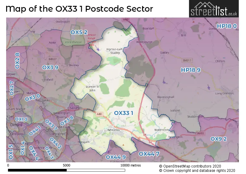
The OX33 1 postcode sector stands on the Buckinghamshire and Oxfordshire border.
Did you know? According to the 2021 Census, the OX33 1 postcode sector is home to a bustling 7,894 residents!
Given that each sector allows for 400 unique postcode combinations. Letters C, I, K, M, O and V are not allowed in the last two letters of a postcode. With 285 postcodes already in use, this leaves 115 units available.
The largest settlement in the OX33 1 postal code is Wheatley followed by Horspath, and Horton-cum-Studley.
The OX33 1 Postcode shares a border with OX3 8 (Headington), OX3 9 (Headington, Beckley, Noke), OX4 2 (OXFORD, Cowley, Oxford Business Park South), OX5 2 (KIDLINGTON, Charlton On Otmoor, Islip), OX9 2 (THAME, Tiddington, Milton Common), HP18 9 (Long Crendon, Brill, Oakley), OX44 7 (Chalgrove, Stadhampton, Great Milton) and OX44 9 (Garsington, Cuddesdon, Nuneham Courtenay).
The sector is within the post town of OXFORD.
OX33 1 is a postcode sector within the OX3 postcode district which is within the OX Oxford postcode area.
The Royal Mail delivery office for the OX33 1 postal sector is the unknown.
The area of the OX33 1 postcode sector is 19.33 square miles which is 50.05 square kilometres or 12,368.60 square acres.
The OX33 1 postcode sector is crossed by the M40 motorway.
Waterways within the OX33 1 postcode sector include the Thame, Cuddeston Brook.

Map of the OX33 1 Postcode Sector
Explore the OX33 1 postcode sector by using our free interactive map.
| O | X | 3 | 3 | - | 1 | X | X |
| O | X | 3 | 3 | Space | 1 | Letter | Letter |
Official List of Streets
Wheatley (61 Streets)
Forest Hill (8 Streets)
Holton (6 Streets)
Stanton St. John (12 Streets)
Horspath (24 Streets)
Horton-cum-Studley (12 Streets)
Waterstock (2 Streets)
Littleworth (3 Streets)
Waterperry (3 Streets)
Woodperry (1 Streets)
Unofficial Streets or Alternative Spellings
Tiddington
ICKFORD ROAD OXFORD ROAD BADGER CLOSE BEECHING WAY BERKELEYPARKS HORSPATH BOW BRIDGE BURYHOOK CORNER COPCOT CLOSE COTTERILLS CLOSE CROMWELL PLACE HOLLY LANE HOLTON PARK DRIVE HORTON HILL ICKFORD BRIDGE MINCHIN COURT POLECAT END LANE SCHOOL LANE SMITHS LANE SNOWS LANE SWORFORD LANE WEATLEY ROAD WELCOME BREAK OXFORD SERVICES WHEATLEY BRIDGE WHEATLEY BYPASS WHEATLEY BYPASS BRIDGE WHEATLEY SPUR WOODPERY HILLOakley
OXFORD ROADHorton-cum-Studley
STRAIGHT MILE ROADWorminghall
MENMARSH ROADBeckley
NEW INN ROAD WOODPERRY ROADHeadington
BAYSWATER ROAD LONDON ROAD OLD ROADIckford
BRIDGE ROADMilton Common
LONDON ROADCuddesdon
WHEATLEY ROADSchools and Places of Education Within the OX33 1 Postcode Sector
Chilworth House School
Other independent special school
Thame Road, Oxford, Oxfordshire, OX33 1JP
Head: Mr David Wilcox
Ofsted Rating: Outstanding
Inspection: 2019-11-14 (1664 days ago)
Website: Visit Chilworth House School Website
Phone: 01844339077
Number of Pupils: 36
Chilworth House Upper School
Other independent special school
Grooms Farm, Oxfordshire, Oxfordshire, OX33 1JP
Head: Mrs Michelle Johnson
Ofsted Rating: Good
Inspection: 2021-12-09 (908 days ago)
Website: Visit Chilworth House Upper School Website
Phone: 01844337720
Number of Pupils: 75
Horspath Church of England Primary School
Academy converter
Blenheim Road, Oxford, Oxfordshire, OX33 1RY
Head: Ms Helen Barnard
Ofsted Rating: Good
Inspection: 2020-03-10 (1547 days ago)
Website: Visit Horspath Church of England Primary School Website
Phone: 01865872702
Number of Pupils: 142
John Watson School
Community special school
Littleworth Road, Oxford, Oxfordshire, OX33 1NN
Head: Mr Tom Pegler
Ofsted Rating: Good
Inspection: 2022-10-19 (594 days ago)
Website: Visit John Watson School Website
Phone: 01865452725
Number of Pupils: 110
Wheatley Church of England Primary School
Academy sponsor led
Littleworth Road, Oxford, Oxfordshire, OX33 1NN
Head: Mrs Gillian Standing
Ofsted Rating: Good
Inspection: 2019-06-20 (1811 days ago)
Website: Visit Wheatley Church of England Primary School Website
Phone: 01865872366
Number of Pupils: 295
Wheatley Nursery School
Local authority nursery school
Littleworth Road, Oxford, Oxfordshire, OX33 1NN
Head: Mrs Natalie Wilson
Ofsted Rating: Good
Inspection: 2023-05-04 (397 days ago)
Website: Visit Wheatley Nursery School Website
Phone: 01865452725
Number of Pupils: 51
Wheatley Park School
Academy converter
Holton, Oxford, Oxfordshire, OX33 1QH
Head: Mr Tim Martin
Ofsted Rating: Good
Inspection: 2022-03-16 (811 days ago)
Website: Visit Wheatley Park School Website
Phone: 01865872441
Number of Pupils: 1138
House Prices in the OX33 1 Postcode Sector
| Type of Property | 2018 Average | 2018 Sales | 2017 Average | 2017 Sales | 2016 Average | 2016 Sales | 2015 Average | 2015 Sales |
|---|---|---|---|---|---|---|---|---|
| Detached | £536,223 | 50 | £588,992 | 72 | £553,300 | 45 | £612,444 | 47 |
| Semi-Detached | £452,909 | 24 | £437,989 | 27 | £388,469 | 28 | £353,083 | 26 |
| Terraced | £378,389 | 18 | £370,176 | 23 | £353,189 | 19 | £286,663 | 20 |
| Flats | £241,071 | 7 | £235,800 | 13 | £223,857 | 14 | £196,250 | 16 |
Important Postcodes OX33 1 in the Postcode Sector
OX33 1HX is the postcode for TERRAPIN, Oxford Brookes University, Wheatley Campus,, ENTRANCE LODGE, Oxford Brookes University, Wheatley Campus,, M BLOCK AND HALLS OF RESIDENCE RC & RD, Oxford Brookes University, Wheatley Campus,, BLOCKS F, G & H INCL. LIBRARY, Oxford Brookes University, Wheatley Campus,, Oxford Brookes University, Wheatley Campus,, A BLOCK AND HALLS OF RESIDENCE RE, RF & RG, Oxford Brookes University, Wheatley Campus,, SCHOOL OF TECHNOLOGY, Oxford Brookes University, Wheatley Campus,, SIMON WILLIAMS BUILDING, Oxford Brookes University, Wheatley Campus,, BLOCKS C, F, H & G, Oxford Brookes University, Wheatley Campus,, HALLS OF RESIDENCE BLOCK RE,RF & RG, Oxford Brookes University, Wheatley Campus,, EIGHTS CAFE, Oxford Brookes University, Wheatley Campus,, O REGAN CENTRE, Oxford Brookes University, Wheatley Campus,, B BLOCK AND POST GRADUATE CENTRE, Oxford Brookes University, Wheatley Campus,, E BLOCK, Oxford Brookes University, Wheatley Campus,, D BLOCK AND HALLS OF RESIDENCE RH & RJ, Oxford Brookes University, Wheatley Campus,, TURING BUILDING, Oxford Brookes University, Wheatley Campus,, HALLS OF RESIDENCE, Oxford Brookes University, Wheatley Campus,, and N BLOCK, Oxford Brookes University, Wheatley Campus,
OX33 1NN is the postcode for The Wheatley Centre, Littleworth Road, John Watson School, Littleworth Road, Wheatley Primary School & Acorns Nursery, Littleworth Road, and Wheatley Primary School, Littleworth Road
OX33 1QH is the postcode for JOHN MILTON CENTRE, Wheatley Park School, Holton, B BLOCK, Wheatley Park School, Holton, A BLOCK, Wheatley Park School, Holton, D BLOCK, Wheatley Park School, Holton, LOWER LABS, Wheatley Park School, Holton, J BLOCK - MATHS, Wheatley Park School, Holton, Wheatley Park School, Holton, and C BLOCK - ENGLISH, Wheatley Park School, Holton
OX33 1QZ is the postcode for The Park Sports Centre, Holton
OX33 1RY is the postcode for Horspath C of E Primary School, Blenheim Road
| The OX33 1 Sector is within these Local Authorities |
|
|---|---|
| The OX33 1 Sector is within these Counties |
|
| The OX33 1 Sector is within these Water Company Areas |
|