The PE28 9 postcode sector is within the county of Cambridgeshire.
Did you know? According to the 2021 Census, the PE28 9 postcode sector is home to a bustling 6,820 residents!
Given that each sector allows for 400 unique postcode combinations. Letters C, I, K, M, O and V are not allowed in the last two letters of a postcode. With 188 postcodes already in use, this leaves 212 units available.
The largest settlement in the PE28 9 postal code is Fenstanton followed by Hemingford Grey, and Hilton.
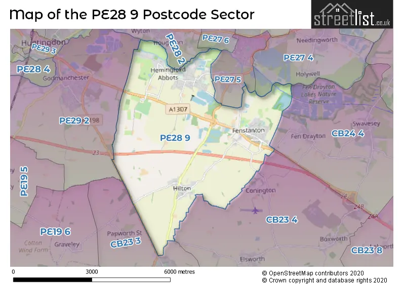
The PE28 9 Postcode shares a border with PE27 4 (Needingworth, ST. IVES, Holywell), PE27 5 (ST. IVES), PE27 6 (ST. IVES), PE28 2 (Warboys, Wyton, Houghton), PE29 2 (Godmanchester), CB23 3 (Papworth Everard, Caxton, Papworth Saint Agnes), CB23 4 (Elsworth, Boxworth, Conington) and CB24 4 (Swavesey, Fen Drayton).
The sector is within the post town of HUNTINGDON.
PE28 9 is a postcode sector within the PE2 postcode district which is within the PE Peterborough postcode area.
The Royal Mail delivery office for the PE28 9 postal sector is the Peterborough South Postal Delivery Office.
The area of the PE28 9 postcode sector is 11.94 square miles which is 30.94 square kilometres or 7,644.78 square acres.
The PE28 9 postcode sector is crossed by the A14 Major A road.
Waterways within the PE28 9 postcode sector include the River Great Ouse.

Map of the PE28 9 Postcode Sector
Explore the PE28 9 postcode sector by using our free interactive map.
| P | E | 2 | 8 | - | 9 | X | X |
| P | E | 2 | 8 | Space | 9 | Letter | Letter |
Official List of Streets
Hemingford Abbots (14 Streets)
Hemingford Grey (47 Streets)
Fenstanton (55 Streets)
Hilton (29 Streets)
Unofficial Streets or Alternative Spellings
Fen Drayton
HUNTINGDON ROADElsworth
ROGUES LANEST. IVES
HEMINGFORD ROAD LONDON ROADHilton
ST. IVES ROADSchools and Places of Education Within the PE28 9 Postcode Sector
Fenstanton and Hilton Primary School
Community school
School Lane, Huntingdon, Cambridgeshire, PE28 9JR
Head: Mr Richard Martin
Ofsted Rating: Good
Inspection: 2023-12-14 (161 days ago)
Website: Visit Fenstanton and Hilton Primary School Website
Phone: 01480375055
Number of Pupils: 228
Hemingford Grey Primary School
Community school
St Ives Road, Huntingdon, Cambridgeshire, PE28 9DU
Head: Co Headteacher Kirsten Marriott & Danielle Gaynor
Ofsted Rating: Good
Inspection: 2018-06-12 (2172 days ago)
Website: Visit Hemingford Grey Primary School Website
Phone: 01480375040
Number of Pupils: 283
House Prices in the PE28 9 Postcode Sector
| Type of Property | 2018 Average | 2018 Sales | 2017 Average | 2017 Sales | 2016 Average | 2016 Sales | 2015 Average | 2015 Sales |
|---|---|---|---|---|---|---|---|---|
| Detached | £504,850 | 72 | £459,336 | 77 | £504,771 | 57 | £477,824 | 55 |
| Semi-Detached | £294,058 | 43 | £263,729 | 24 | £303,438 | 32 | £279,683 | 32 |
| Terraced | £247,413 | 23 | £299,700 | 10 | £264,538 | 25 | £229,336 | 17 |
| Flats | £201,667 | 3 | £158,500 | 2 | £160,300 | 5 | £166,000 | 3 |
Important Postcodes PE28 9 in the Postcode Sector
PE28 9DU is the postcode for HEMINGFORD GREY PRIMARY SCHOOL, ST IVES ROAD, HEMINGFORD GREY, Hemingford Grey Primary School, St Ives Road, and Hemingford Grey Primary School, St. Ives Road
PE28 9JR is the postcode for Fenstanton Cp School, School Lane, and Fenstanton And Hilton Primary School, School Lane
| The PE28 9 Sector is within these Local Authorities |
|
|---|---|
| The PE28 9 Sector is within these Counties |
|
| The PE28 9 Sector is within these Water Company Areas |
|