The PE2 postcode district is a postal district located in the PE Peterborough postcode area with a population of 53,616 residents according to the 2021 England and Wales Census.
The area of the PE2 postcode district is 9.04 square miles which is 23.40 square kilometres or 5,783.36 acres.
Currently, the PE2 district has about 973 postcode units spread across 41 geographic postcode sectors.
Given that each sector allows for 400 unique postcode combinations, the district has a capacity of 16,400 postcodes. With 973 postcodes already in use, this leaves 15427 units available.
The largest settlement in the PE2 postal code is PETERBOROUGH followed by Orton Goldhay, and Orton Malborne.
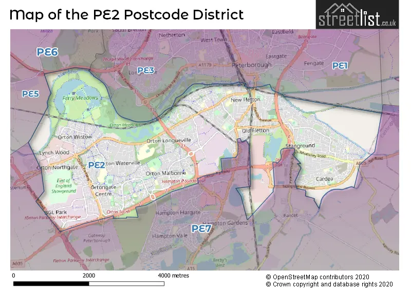
The PE2 Postcode shares a border with PE7 (Whittlesey, Yaxley, Hampton Vale), PE3 (PETERBOROUGH, Bretton, Longthorpe), PE6 (Market Deeping, Deeping St. James, Crowland) and PE1 (PETERBOROUGH).
The primary settlement in the PE2 postcode district is Peterborough, located in the county of Cambridgeshire, England. Other significant settlements within the district include Orton Brimbles, Orton Goldhay, Orton Malborne, Orton Waterville, Alwalton, Lynch Wood, Orton Northgate, Orton Southgate, Orton Wistow, Orton Longueville, Fletton Quays, Stanground, and Woodston. The main post town in the district is Peterborough.
For the district PE2, we have data on 6 postcode sectors. Here's a breakdown: The sector PE2 2 is non-geographic. It's often designated for PO Boxes, large organisations, or special services. The sector PE2 5, covers Orton Goldhay and Orton Malborne and Orton Waterville and Orton Brimbles in Cambridgeshire. The sector PE2 6, covers Orton Southgate and Orton Wistow and Lynch Wood and Orton Northgate in Cambridgeshire. The sector PE2 7, covers Orton Longueville and Peterborough in Cambridgeshire. The sector PE2 8, covers Peterborough and Stanground in Cambridgeshire. The sector PE2 9, covers Peterborough in Cambridgeshire.

Map of the PE2 Postcode District
Explore the PE2 postcode district by using our free interactive map.
When it comes to local government, postal geography often disregards political borders. However, for a breakdown in the PE2 District: the district mostly encompasses the City of Peterborough (B) (988 postcodes), and finally, the Huntingdonshire District area (3 postcodes).
Recent House Sales in PE21
| Date | Price | Address |
|---|---|---|
| 24/10/2023 | £200,000 | Francis Bernard Close, Boston, PE21 8BL |
| 13/10/2023 | £247,500 | The Moorings, Boston, PE21 9HP |
| 13/10/2023 | £250,000 | Blackthorn Lane, Boston, PE21 9BG |
| 13/10/2023 | £150,000 | Taylor Close, Fishtoft, Boston, PE21 0NL |
| 10/10/2023 | £130,000 | Harrison Court, Boston, PE21 8XY |
| 05/10/2023 | £250,000 | Tattershall Road, Boston, PE21 9LR |
| 02/10/2023 | £125,000 | Sheriff Way, Boston, PE21 9EU |
| 28/09/2023 | £168,000 | Medforth Lane, Boston, PE21 9HW |
| 28/09/2023 | £365,000 | Bayford Green, Boston, PE21 7TU |
| 26/09/2023 | £115,000 | Hartley Street, Boston, PE21 9BS |
Where is the PE2 Postcode District?
The postcode district PE2 is located in Peterborough. It is situated in close proximity to several nearby towns. To the North West, there is Stamford, which is approximately 11.8 miles away. To the East lies March, located around 14.3 miles from PE2. Bourne is situated to the North, at a distance of 15.4 miles. Chatteris is located to the South East, approximately 15.6 miles away, and Huntingdon is situated to the South, approximately 16.9 miles away. Additionally, Corby is located to the West, around 18.4 miles away. The town of Peterborough, where the postcode is located, is approximately 72.6 miles away from the center of London.
The district covers the post towns of PETERBOROUGH, STAMFORD.
The sector has postcodes within the nation of England.
The PE2 Postcode District is covers the following regions.
- Peterborough - East Anglia - East of England
- Cambridgeshire CC - East Anglia - East of England
Weather Forecast for PE2
Press Button to Show Forecast for West Town Primary Academy
| Time Period | Icon | Description | Temperature | Rain Probability | Wind |
|---|---|---|---|---|---|
| 21:00 to 00:00 | Clear night | 16.0°C (feels like 15.0°C) | 0.00% | SE 7 mph |
Press Button to Show Forecast for West Town Primary Academy
| Time Period | Icon | Description | Temperature | Rain Probability | Wind |
|---|---|---|---|---|---|
| 00:00 to 03:00 | Partly cloudy (night) | 13.0°C (feels like 12.0°C) | 0.00% | SE 4 mph | |
| 03:00 to 06:00 | Partly cloudy (night) | 11.0°C (feels like 10.0°C) | 0.00% | ESE 4 mph | |
| 06:00 to 09:00 | Cloudy | 11.0°C (feels like 10.0°C) | 3.00% | ESE 4 mph | |
| 09:00 to 12:00 | Partly cloudy (day) | 16.0°C (feels like 16.0°C) | 0.00% | E 4 mph | |
| 12:00 to 15:00 | Partly cloudy (day) | 21.0°C (feels like 20.0°C) | 0.00% | SE 7 mph | |
| 15:00 to 18:00 | Partly cloudy (day) | 23.0°C (feels like 21.0°C) | 1.00% | SE 9 mph | |
| 18:00 to 21:00 | Partly cloudy (day) | 21.0°C (feels like 18.0°C) | 0.00% | ESE 11 mph | |
| 21:00 to 00:00 | Partly cloudy (night) | 16.0°C (feels like 14.0°C) | 0.00% | ESE 9 mph |
Press Button to Show Forecast for West Town Primary Academy
| Time Period | Icon | Description | Temperature | Rain Probability | Wind |
|---|---|---|---|---|---|
| 00:00 to 03:00 | Partly cloudy (night) | 13.0°C (feels like 12.0°C) | 0.00% | E 4 mph | |
| 03:00 to 06:00 | Partly cloudy (night) | 12.0°C (feels like 11.0°C) | 1.00% | E 4 mph | |
| 06:00 to 09:00 | Cloudy | 14.0°C (feels like 13.0°C) | 3.00% | E 4 mph | |
| 09:00 to 12:00 | Cloudy | 18.0°C (feels like 17.0°C) | 3.00% | ESE 7 mph | |
| 12:00 to 15:00 | Cloudy | 22.0°C (feels like 21.0°C) | 9.00% | SE 9 mph | |
| 15:00 to 18:00 | Cloudy | 23.0°C (feels like 20.0°C) | 12.00% | SE 11 mph | |
| 18:00 to 21:00 | Cloudy | 21.0°C (feels like 19.0°C) | 13.00% | SSE 9 mph | |
| 21:00 to 00:00 | Cloudy | 17.0°C (feels like 16.0°C) | 10.00% | SSE 7 mph |
Press Button to Show Forecast for West Town Primary Academy
| Time Period | Icon | Description | Temperature | Rain Probability | Wind |
|---|---|---|---|---|---|
| 00:00 to 03:00 | Cloudy | 15.0°C (feels like 15.0°C) | 9.00% | S 7 mph | |
| 03:00 to 06:00 | Cloudy | 14.0°C (feels like 13.0°C) | 10.00% | S 7 mph | |
| 06:00 to 09:00 | Cloudy | 14.0°C (feels like 13.0°C) | 8.00% | S 9 mph | |
| 09:00 to 12:00 | Cloudy | 16.0°C (feels like 14.0°C) | 9.00% | S 11 mph | |
| 12:00 to 15:00 | Cloudy | 18.0°C (feels like 16.0°C) | 14.00% | S 13 mph | |
| 15:00 to 18:00 | Cloudy | 18.0°C (feels like 15.0°C) | 16.00% | S 13 mph | |
| 18:00 to 21:00 | Light rain | 16.0°C (feels like 14.0°C) | 50.00% | SSE 13 mph | |
| 21:00 to 00:00 | Light rain | 15.0°C (feels like 13.0°C) | 54.00% | SSE 11 mph |
Press Button to Show Forecast for West Town Primary Academy
| Time Period | Icon | Description | Temperature | Rain Probability | Wind |
|---|---|---|---|---|---|
| 00:00 to 03:00 | Light rain | 14.0°C (feels like 12.0°C) | 51.00% | SSE 9 mph | |
| 03:00 to 06:00 | Cloudy | 13.0°C (feels like 11.0°C) | 20.00% | SSE 9 mph | |
| 06:00 to 09:00 | Cloudy | 13.0°C (feels like 11.0°C) | 11.00% | SSE 9 mph | |
| 09:00 to 12:00 | Cloudy | 15.0°C (feels like 12.0°C) | 12.00% | S 13 mph | |
| 12:00 to 15:00 | Light rain shower (day) | 17.0°C (feels like 14.0°C) | 35.00% | S 13 mph | |
| 15:00 to 18:00 | Light rain shower (day) | 17.0°C (feels like 14.0°C) | 33.00% | S 13 mph | |
| 18:00 to 21:00 | Light rain shower (day) | 16.0°C (feels like 13.0°C) | 30.00% | S 13 mph | |
| 21:00 to 00:00 | Partly cloudy (night) | 13.0°C (feels like 11.0°C) | 3.00% | S 11 mph |
Postcode Sectors within the PE2 District
| Postcode Sector | Delivery Office |
|---|---|
| PE2 5 | Peterborough South Postal Delivery Office |
| PE2 6 | Peterborough South Postal Delivery Office |
| PE2 7 | Peterborough South Postal Delivery Office |
| PE2 8 | Peterborough South Postal Delivery Office |
| PE2 9 | Peterborough South Postal Delivery Office |
| P | E | 2 | - | X | X | X |
| P | E | 2 | Space | Numeric | Letter | Letter |
Tourist Attractions within the PE2 Postcode Area
We found 1 visitor attractions within the PE2 postcode area
| Ferry Meadows |
|---|
| Country Parks |
| Country Park |
| View Ferry Meadows on Google Maps |
Current Monthly Rental Prices
| # Bedrooms | Min Price | Max Price | Avg Price |
|---|---|---|---|
| 1 | £425 | £1,095 | £632 |
| 2 | £750 | £2,353 | £1,046 |
| 3 | £895 | £1,500 | £1,124 |
| 4 | £1,050 | £3,295 | £1,773 |
| 5 | £1,700 | £2,200 | £1,950 |
| 6 | £693 | £693 | £693 |
Current House Prices
| # Bedrooms | Min Price | Max Price | Avg Price |
|---|---|---|---|
| £85,000 | £695,000 | £242,000 | |
| 1 | £42,500 | £210,000 | £115,652 |
| 2 | £65,000 | £380,000 | £180,285 |
| 3 | £140,000 | £725,000 | £284,074 |
| 4 | £175,000 | £699,950 | £375,381 |
| 5 | £290,000 | £1,100,000 | £477,963 |
| 6 | £430,000 | £825,000 | £627,500 |
| 8 | £2,350,000 | £2,350,000 | £2,350,000 |
Estate Agents who Operate in the PE2 District
| Logo | Name | Brand Name | Address | Contact Number | Total Properties |
|---|---|---|---|---|---|
 | Fletton | William H. Brown | 122 High Street, Old Fletton, Peterborough, PE2 8DP | 01733 964686 | 30 |
 | Stanground | Sharman Quinney | 13 Desborough Avenue Stanground Peterborough PE2 8RG | 01733 964727 | 25 |
 | Peterborough | Century 21 | 4 Cowgate, Peterborough, PE1 1NA | 01733 889988 | 23 |
 | Peterborough | City & County (UK) Ltd | 6 Cowgate Peterborough PE1 1NA | 01733 964731 | 23 |
 | Peterborough | William H. Brown | 7-9 Cowgate, Peterborough, PE1 1LR | 01733 964717 | 20 |
Yearly House Price Averages for the PE2 Postcode District
| Type of Property | 2018 Average | 2018 Sales | 2017 Average | 2017 Sales | 2016 Average | 2016 Sales | 2015 Average | 2015 Sales |
|---|---|---|---|---|---|---|---|---|
| Detached | £269,597 | 252 | £276,008 | 278 | £251,372 | 371 | £231,682 | 337 |
| Semi-Detached | £188,861 | 279 | £181,041 | 302 | £173,122 | 369 | £166,325 | 361 |
| Terraced | £152,441 | 271 | £142,373 | 314 | £134,641 | 351 | £131,594 | 397 |
| Flats | £106,153 | 108 | £101,559 | 107 | £94,828 | 168 | £83,983 | 130 |