The PO22 8 postcode sector is within the county of West Sussex.
Did you know? According to the 2021 Census, the PO22 8 postcode sector is home to a bustling 8,237 residents!
Given that each sector allows for 400 unique postcode combinations. Letters C, I, K, M, O and V are not allowed in the last two letters of a postcode. With 211 postcodes already in use, this leaves 189 units available.
The largest settlement in the PO22 8 postal code is BOGNOR REGIS followed by Felpham, and Flansham.
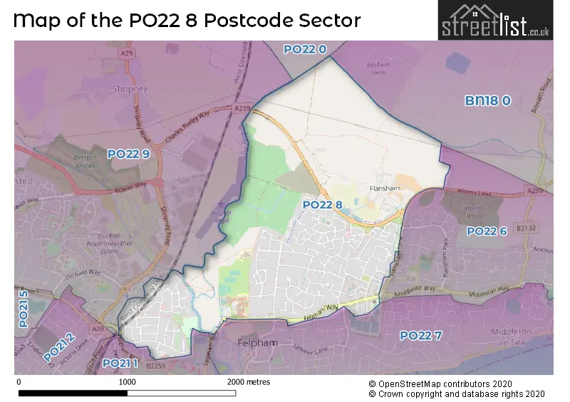
The PO22 8 Postcode shares a border with PO21 1 (BOGNOR REGIS), PO22 0 (Barnham), PO22 6 (BOGNOR REGIS, Elmer, Middleton-on-Sea), PO22 7 (BOGNOR REGIS, Middleton-on-Sea, Felpham), PO22 9 (BOGNOR REGIS, Poplars Court, South Bersted) and BN18 0 (Yapton, Walberton, Ford).
The sector is within the post town of BOGNOR REGIS.
PO22 8 is a postcode sector within the PO21 postcode district which is within the PO Portsmouth postcode area.
The Royal Mail delivery office for the PO22 8 postal sector is the unknown.
The area of the PO22 8 postcode sector is 1.55 square miles which is 4.03 square kilometres or 995.08 square acres.

Map of the PO22 8 Postcode Sector
Explore the PO22 8 postcode sector by using our free interactive map.
| P | O | 2 | 2 | - | 8 | X | X |
| P | O | 2 | 2 | Space | 8 | Letter | Letter |
Official List of Streets
Felpham (33 Streets)
BOGNOR REGIS (85 Streets)
Unofficial Streets or Alternative Spellings
House Prices in the PO22 8 Postcode Sector
| Type of Property | 2018 Average | 2018 Sales | 2017 Average | 2017 Sales | 2016 Average | 2016 Sales | 2015 Average | 2015 Sales |
|---|---|---|---|---|---|---|---|---|
| Detached | £372,116 | 57 | £384,562 | 76 | £374,339 | 81 | £342,080 | 90 |
| Semi-Detached | £278,645 | 66 | £281,618 | 51 | £274,805 | 55 | £250,327 | 64 |
| Terraced | £264,921 | 53 | £251,756 | 41 | £257,972 | 62 | £243,779 | 54 |
| Flats | £183,133 | 15 | £150,458 | 12 | £160,653 | 13 | £144,025 | 14 |
Important Postcodes PO22 8 in the Postcode Sector
PO22 8ED is the postcode for Arun Leisure Centre, Felpham Way, and DRY SPORTS AND LEISURE FACILITY, Arun Leisure Centre, Felpham Way
PO22 8EL is the postcode for BLOCK A, Felpham Community College, Felpham Way, NORTH BLOCK, Felpham Community College, Felpham Way, VOCAL BLOCK, Felpham Community College, Felpham Way, SIXTH FORM, Felpham Community College, Felpham Way, BLOCK B, Felpham Community College, Felpham Way, SCIENCE BLOCK, Felpham Community College, Felpham Way, and Felpham Community College, Felpham Way
PO22 8ER is the postcode for MAIN BUILDING, Downview Cp School, Wroxham Way, Downview Cp School, Wroxham Way, and ALLEN BUILDING, Downview Cp School, Wroxham Way
| The PO22 8 Sector is within these Local Authorities |
|
|---|---|
| The PO22 8 Sector is within these Counties |
|
| The PO22 8 Sector is within these Water Company Areas |
|