The PR9 9 postcode sector is within the county of Merseyside.
Did you know? According to the 2021 Census, the PR9 9 postcode sector is home to a bustling 14,455 residents!
Given that each sector allows for 400 unique postcode combinations. Letters C, I, K, M, O and V are not allowed in the last two letters of a postcode. With 301 postcodes already in use, this leaves 99 units available.
The PR9 9 postal code covers the settlement of SOUTHPORT.
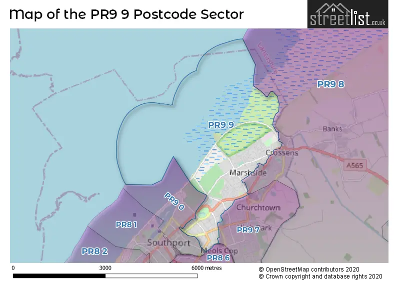
The PR9 9 Postcode shares a border with PR8 6 (SOUTHPORT), PR9 7 (SOUTHPORT, Churchtown), PR9 0 (SOUTHPORT) and PR9 8 (SOUTHPORT, Banks).
The sector is within the post town of SOUTHPORT.
PR9 9 is a postcode sector within the PR9 postcode district which is within the PR Preston postcode area.
The Royal Mail delivery office for the PR9 9 postal sector is the Southport Delivery Office.
The area of the PR9 9 postcode sector is 4.34 square miles which is 11.24 square kilometres or 2,776.24 square acres.

Map of the PR9 9 Postcode Sector
Explore the PR9 9 postcode sector by using our free interactive map.
| P | R | 9 | - | 9 | X | X |
| P | R | 9 | Space | 9 | Letter | Letter |
Official List of Streets
SOUTHPORT (130 Streets)
Unofficial Streets or Alternative Spellings
SOUTHPORT
ARNSIDE ROAD BIBBY ROAD BRENTWOOD COURT CLIFF ROAD FERRY SIDE LANE HALL STREET HOGHTON STREET LARKFIELD LANE LAUREL GROVE MARLBOROUGH ROAD MOUNT STREET MYRTLE GROVE OLIVE GROVE PRESTON NEW ROAD ROOKERY ROAD SUSSEX ROAD TRINITY MEWS WILLOW GROVE COASTLINE MEWS DARWIN COURT KESTREL COURT KINGFISHER COURTWeather Forecast for PR9 9
Press Button to Show Forecast for Crossens
| Time Period | Icon | Description | Temperature | Rain Probability | Wind |
|---|---|---|---|---|---|
| 15:00 to 18:00 | Cloudy | 8.0°C (feels like 6.0°C) | 51.00% | NE 9 mph | |
| 18:00 to 21:00 | Cloudy | 8.0°C (feels like 6.0°C) | 44.00% | NNE 9 mph | |
| 21:00 to 00:00 | Cloudy | 7.0°C (feels like 4.0°C) | 5.00% | E 9 mph |
Press Button to Show Forecast for Crossens
| Time Period | Icon | Description | Temperature | Rain Probability | Wind |
|---|---|---|---|---|---|
| 00:00 to 03:00 | Cloudy | 6.0°C (feels like 4.0°C) | 4.00% | E 7 mph | |
| 03:00 to 06:00 | Partly cloudy (night) | 4.0°C (feels like 1.0°C) | 1.00% | ENE 9 mph | |
| 06:00 to 09:00 | Sunny day | 4.0°C (feels like 1.0°C) | 2.00% | ENE 9 mph | |
| 09:00 to 12:00 | Partly cloudy (day) | 9.0°C (feels like 6.0°C) | 4.00% | ENE 9 mph | |
| 12:00 to 15:00 | Cloudy | 11.0°C (feels like 9.0°C) | 5.00% | ENE 9 mph | |
| 15:00 to 18:00 | Overcast | 10.0°C (feels like 8.0°C) | 18.00% | ENE 9 mph | |
| 18:00 to 21:00 | Cloudy | 9.0°C (feels like 7.0°C) | 8.00% | NE 9 mph | |
| 21:00 to 00:00 | Cloudy | 7.0°C (feels like 5.0°C) | 5.00% | ENE 9 mph |
Press Button to Show Forecast for Crossens
| Time Period | Icon | Description | Temperature | Rain Probability | Wind |
|---|---|---|---|---|---|
| 00:00 to 03:00 | Cloudy | 6.0°C (feels like 3.0°C) | 5.00% | NE 7 mph | |
| 03:00 to 06:00 | Cloudy | 5.0°C (feels like 2.0°C) | 4.00% | NNE 9 mph | |
| 06:00 to 09:00 | Cloudy | 6.0°C (feels like 3.0°C) | 7.00% | N 11 mph | |
| 09:00 to 12:00 | Cloudy | 8.0°C (feels like 5.0°C) | 8.00% | NNW 11 mph | |
| 12:00 to 15:00 | Cloudy | 10.0°C (feels like 7.0°C) | 9.00% | NW 13 mph | |
| 15:00 to 18:00 | Sunny day | 10.0°C (feels like 7.0°C) | 6.00% | WNW 13 mph | |
| 18:00 to 21:00 | Sunny day | 10.0°C (feels like 7.0°C) | 2.00% | W 13 mph | |
| 21:00 to 00:00 | Clear night | 8.0°C (feels like 6.0°C) | 1.00% | SW 11 mph |
Press Button to Show Forecast for Crossens
| Time Period | Icon | Description | Temperature | Rain Probability | Wind |
|---|---|---|---|---|---|
| 00:00 to 03:00 | Partly cloudy (night) | 7.0°C (feels like 5.0°C) | 2.00% | SSW 9 mph | |
| 03:00 to 06:00 | Partly cloudy (night) | 6.0°C (feels like 3.0°C) | 2.00% | SSE 9 mph | |
| 06:00 to 09:00 | Cloudy | 7.0°C (feels like 3.0°C) | 7.00% | SSE 11 mph | |
| 09:00 to 12:00 | Cloudy | 10.0°C (feels like 7.0°C) | 6.00% | SSE 13 mph | |
| 12:00 to 15:00 | Cloudy | 13.0°C (feels like 10.0°C) | 7.00% | S 16 mph | |
| 15:00 to 18:00 | Cloudy | 14.0°C (feels like 11.0°C) | 11.00% | S 16 mph | |
| 18:00 to 21:00 | Partly cloudy (day) | 13.0°C (feels like 10.0°C) | 6.00% | SSE 13 mph | |
| 21:00 to 00:00 | Clear night | 11.0°C (feels like 8.0°C) | 3.00% | SSE 13 mph |
Press Button to Show Forecast for Crossens
| Time Period | Icon | Description | Temperature | Rain Probability | Wind |
|---|---|---|---|---|---|
| 00:00 to 03:00 | Partly cloudy (night) | 9.0°C (feels like 7.0°C) | 3.00% | SE 13 mph | |
| 03:00 to 06:00 | Partly cloudy (night) | 8.0°C (feels like 6.0°C) | 3.00% | SE 11 mph | |
| 06:00 to 09:00 | Partly cloudy (day) | 9.0°C (feels like 6.0°C) | 3.00% | ESE 13 mph | |
| 09:00 to 12:00 | Partly cloudy (day) | 12.0°C (feels like 9.0°C) | 2.00% | ESE 16 mph | |
| 12:00 to 15:00 | Partly cloudy (day) | 15.0°C (feels like 12.0°C) | 3.00% | SE 16 mph | |
| 15:00 to 18:00 | Cloudy | 16.0°C (feels like 13.0°C) | 8.00% | SE 13 mph | |
| 18:00 to 21:00 | Cloudy | 15.0°C (feels like 13.0°C) | 9.00% | ESE 11 mph | |
| 21:00 to 00:00 | Cloudy | 12.0°C (feels like 10.0°C) | 6.00% | ESE 11 mph |
Schools and Places of Education Within the PR9 9 Postcode Sector
Holy Trinity Church of England Primary School, Southport
Academy converter
Manchester Road, Southport, Merseyside, PR9 9AZ
Head: Mrs Linda Thompson
Ofsted Rating: Good
Inspection: 2022-05-05 (722 days ago)
Website: Visit Holy Trinity Church of England Primary School, Southport Website
Phone: 01704538366
Number of Pupils: 209
Marshside Primary School
Community school
Elswick Road, Southport, Merseyside, PR9 9XA
Head: Mrs Natasha Sandland
Ofsted Rating: Good
Inspection: 2023-09-27 (212 days ago)
Website: Visit Marshside Primary School Website
Phone: 01704211177
Number of Pupils: 172
St Patrick's Catholic Primary School
Voluntary aided school
Radnor Drive, Southport, Lancashire, PR9 9RR
Head: Mrs R Halsall
Ofsted Rating: Outstanding
Inspection: 2013-03-13 (4062 days ago)
Website: Visit St Patrick's Catholic Primary School Website
Phone: 01704225906
Number of Pupils: 344
Stanley High School
Academy sponsor led
Fleetwood Road, Southport, Merseyside, PR9 9TF
Head: Mrs Jenna Shawe
Ofsted Rating: Good
Inspection: 2020-02-12 (1535 days ago)
Website: Visit Stanley High School Website
Phone: 01704228940
Number of Pupils: 814
House Prices in the PR9 9 Postcode Sector
| Type of Property | 2018 Average | 2018 Sales | 2017 Average | 2017 Sales | 2016 Average | 2016 Sales | 2015 Average | 2015 Sales |
|---|---|---|---|---|---|---|---|---|
| Detached | £297,753 | 69 | £292,196 | 56 | £264,582 | 45 | £260,631 | 57 |
| Semi-Detached | £190,119 | 129 | £176,857 | 109 | £167,643 | 116 | £161,159 | 111 |
| Terraced | £151,708 | 13 | £154,964 | 18 | £140,321 | 17 | £126,615 | 13 |
| Flats | £124,846 | 104 | £117,488 | 85 | £108,716 | 100 | £112,439 | 110 |
Important Postcodes PR9 9 in the Postcode Sector
PR9 9AZ is the postcode for Holy Trinity C of E Primary School, Manchester Road
PR9 9RR is the postcode for St. Patricks Primary School, Radnor Drive
PR9 9TF is the postcode for SPORTS HALL, Stanley High School, Fleetwood Road, and MAIN BUILDING, Stanley High School, Fleetwood Road
PR9 9XA is the postcode for Marshside Primary School, Elswick Road
PR9 9XP is the postcode for Doctors Surgery, 117 Fylde Road Industrial Estate, Fylde Road
| The PR9 9 Sector is within these Local Authorities |
|
|---|---|
| The PR9 9 Sector is within these Counties |
|
| The PR9 9 Sector is within these Water Company Areas |
|