The PR9 7 postcode sector stands on the Lancashire and Merseyside border.
Did you know? According to the 2021 Census, the PR9 7 postcode sector is home to a bustling 11,325 residents!
Given that each sector allows for 400 unique postcode combinations. Letters C, I, K, M, O and V are not allowed in the last two letters of a postcode. With 200 postcodes already in use, this leaves 200 units available.
The largest settlements in the PR9 7 postal code are SOUTHPORT and Churchtown.
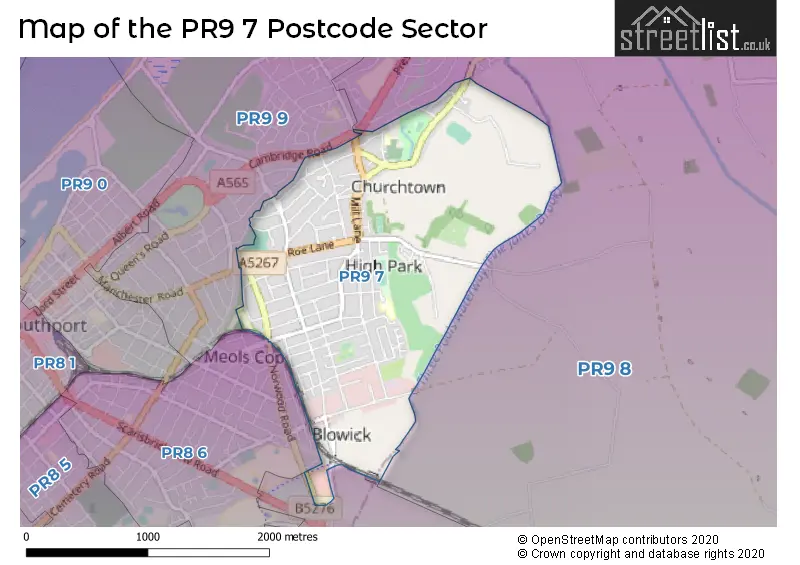
The PR9 7 Postcode shares a border with PR8 6 (SOUTHPORT), PR8 5 (SOUTHPORT, Scarisbrick), PR9 8 (SOUTHPORT, Banks) and PR9 9 (SOUTHPORT).
The sector is within the post town of SOUTHPORT.
PR9 7 is a postcode sector within the PR9 postcode district which is within the PR Preston postcode area.
The Royal Mail delivery office for the PR9 7 postal sector is the Southport Delivery Office.
The area of the PR9 7 postcode sector is 1.86 square miles which is 4.81 square kilometres or 1,188.05 square acres.

Map of the PR9 7 Postcode Sector
Explore the PR9 7 postcode sector by using our free interactive map.
| P | R | 9 | - | 7 | X | X |
| P | R | 9 | Space | 7 | Letter | Letter |
Official List of Streets
SOUTHPORT (96 Streets)
Unofficial Streets or Alternative Spellings
Weather Forecast for PR9 7
Press Button to Show Forecast for Crossens
| Time Period | Icon | Description | Temperature | Rain Probability | Wind |
|---|---|---|---|---|---|
| 03:00 to 06:00 | Clear night | 3.0°C (feels like 0.0°C) | 1.00% | ENE 7 mph | |
| 06:00 to 09:00 | Sunny day | 3.0°C (feels like 1.0°C) | 1.00% | ENE 7 mph | |
| 09:00 to 12:00 | Sunny day | 7.0°C (feels like 6.0°C) | 1.00% | ENE 4 mph | |
| 12:00 to 15:00 | Cloudy | 9.0°C (feels like 8.0°C) | 8.00% | NE 7 mph | |
| 15:00 to 18:00 | Light rain shower (day) | 10.0°C (feels like 9.0°C) | 28.00% | NE 4 mph | |
| 18:00 to 21:00 | Partly cloudy (day) | 9.0°C (feels like 8.0°C) | 3.00% | NNE 7 mph | |
| 21:00 to 00:00 | Cloudy | 6.0°C (feels like 3.0°C) | 6.00% | NE 7 mph |
Press Button to Show Forecast for Crossens
| Time Period | Icon | Description | Temperature | Rain Probability | Wind |
|---|---|---|---|---|---|
| 00:00 to 03:00 | Cloudy | 4.0°C (feels like 2.0°C) | 6.00% | E 7 mph | |
| 03:00 to 06:00 | Partly cloudy (night) | 3.0°C (feels like 0.0°C) | 5.00% | E 7 mph | |
| 06:00 to 09:00 | Partly cloudy (day) | 4.0°C (feels like 1.0°C) | 4.00% | E 7 mph | |
| 09:00 to 12:00 | Partly cloudy (day) | 8.0°C (feels like 6.0°C) | 5.00% | ESE 9 mph | |
| 12:00 to 15:00 | Overcast | 10.0°C (feels like 9.0°C) | 12.00% | E 7 mph | |
| 15:00 to 18:00 | Overcast | 11.0°C (feels like 9.0°C) | 16.00% | ENE 9 mph | |
| 18:00 to 21:00 | Cloudy | 10.0°C (feels like 8.0°C) | 10.00% | ENE 9 mph | |
| 21:00 to 00:00 | Partly cloudy (night) | 7.0°C (feels like 5.0°C) | 10.00% | NE 9 mph |
Press Button to Show Forecast for Crossens
| Time Period | Icon | Description | Temperature | Rain Probability | Wind |
|---|---|---|---|---|---|
| 00:00 to 03:00 | Cloudy | 6.0°C (feels like 3.0°C) | 15.00% | NE 9 mph | |
| 03:00 to 06:00 | Cloudy | 6.0°C (feels like 3.0°C) | 14.00% | NNE 9 mph | |
| 06:00 to 09:00 | Light rain | 7.0°C (feels like 3.0°C) | 48.00% | N 11 mph | |
| 09:00 to 12:00 | Light rain | 8.0°C (feels like 5.0°C) | 49.00% | N 11 mph | |
| 12:00 to 15:00 | Cloudy | 9.0°C (feels like 6.0°C) | 20.00% | N 11 mph | |
| 15:00 to 18:00 | Light rain | 10.0°C (feels like 7.0°C) | 51.00% | NNW 11 mph | |
| 18:00 to 21:00 | Partly cloudy (day) | 10.0°C (feels like 8.0°C) | 13.00% | NNW 11 mph | |
| 21:00 to 00:00 | Clear night | 8.0°C (feels like 5.0°C) | 9.00% | NW 9 mph |
Schools and Places of Education Within the PR9 7 Postcode Sector
Bishop David Sheppard Church of England Primary School
Voluntary aided school
Devonshire Road, Southport, Merseyside, PR9 7BZ
Head: Mrs Siobhan Bayliff
Ofsted Rating: Good
Inspection: 2023-05-19 (343 days ago)
Website: Visit Bishop David Sheppard Church of England Primary School Website
Phone: 01704227987
Number of Pupils: 203
Churchtown Primary School
Academy converter
St Cuthbert's Road, Southport, Merseyside, PR9 7NN
Head: Mrs Jinnie Payne
Ofsted Rating: Good
Inspection: 2023-06-14 (317 days ago)
Website: Visit Churchtown Primary School Website
Phone: 01704508500
Number of Pupils: 743
Holy Family Catholic Primary School
Voluntary aided school
Norwood Crescent, Southport, Merseyside, PR9 7DU
Head: Miss Marie Hilton
Ofsted Rating: Good
Inspection: 2019-01-24 (1919 days ago)
Website: Visit Holy Family Catholic Primary School Website
Phone: 01704213084
Number of Pupils: 202
Norwood Primary School
Community school
Norwood Crescent, Southport, Merseyside, PR9 7DU
Head: Mr Lee Dumbell
Ofsted Rating: Good
Inspection: 2022-11-09 (534 days ago)
Website: Visit Norwood Primary School Website
Phone: 01704211960
Number of Pupils: 620
House Prices in the PR9 7 Postcode Sector
| Type of Property | 2018 Average | 2018 Sales | 2017 Average | 2017 Sales | 2016 Average | 2016 Sales | 2015 Average | 2015 Sales |
|---|---|---|---|---|---|---|---|---|
| Detached | £262,818 | 25 | £295,279 | 31 | £272,010 | 26 | £279,104 | 26 |
| Semi-Detached | £166,884 | 148 | £158,407 | 160 | £158,190 | 125 | £152,528 | 150 |
| Terraced | £144,455 | 11 | £128,727 | 11 | £119,158 | 6 | £117,500 | 7 |
| Flats | £89,250 | 6 | £92,600 | 10 | £86,161 | 9 | £80,909 | 11 |
Important Postcodes PR9 7 in the Postcode Sector
PR9 7BZ is the postcode for Bishop David Sheppard C of E School, Devonshire Road
PR9 7DU is the postcode for Norwood Primary School, Norwood Crescent, and Holy Family Catholic Primary, Norwood Crescent
PR9 7EG is the postcode for Norwood Surgery, 11 Norwood Avenue
PR9 7LG is the postcode for 27, Chase Heys, and Chase Heys Home For The Elderly, 27, Chase Heys
PR9 7LT is the postcode for CHURCHTOWN CLINIC, Church Town Health Centre, 137 Cambridge Road, and Church Town Health Centre, 137 Cambridge Road
PR9 7LW is the postcode for Birchall Blackburn Llp, 180 Cambridge Road
PR9 7NB is the postcode for Botanic Gardens Museum, Botanic Gardens
PR9 7NN is the postcode for MAIN BUILDING, Churchtown Primary School, St. Cuthberts Road, Churchtown Primary School, St. Cuthberts Road, and EARLY YEARS CENTRE, Churchtown Primary School, St. Cuthberts Road
| The PR9 7 Sector is within these Local Authorities |
|
|---|---|
| The PR9 7 Sector is within these Counties |
|
| The PR9 7 Sector is within these Water Company Areas |
|