The RG9 postcode district is a postal district located in the RG Reading postcode area with a population of 23,698 residents according to the 2021 England and Wales Census.
The area of the RG9 postcode district is 61.00 square miles which is 158.00 square kilometres or 39,042.18 acres.
Currently, the RG9 district has about 1138 postcode units spread across 6 geographic postcode sectors.
Given that each sector allows for 400 unique postcode combinations, the district has a capacity of 2,400 postcodes. With 1138 postcodes already in use, this leaves 1262 units available.
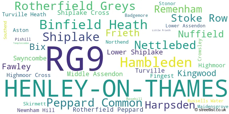
The largest settlement in the RG9 postal code is HENLEY-ON-THAMES followed by Hambleden, and Shiplake.
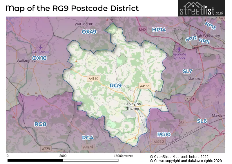
The RG9 Postcode shares a border with OX10 (WALLINGFORD, Benson, Cholsey), HP14 (Stokenchurch, Lane End, Walters Ash), SL7 (MARLOW, Medmenham, Booker), OX49 (WATLINGTON, Lewknor, Aston Rowant), RG10 (Twyford, Wargrave, Charvil) and RG4 (Caversham, Emmer Green, Sonning Common).
The primary settlement in the RG9 postcode district is Henley-on-Thames, which is located in Oxfordshire. Other significant settlements in this district include Remenham, Aston, Fawley, Hambleden, Lower Shiplake, Rosehill, Templecombe, Badgemore, Binfield Heath, Bix, Crowsley, Harpsden, Rotherfield Greys, Shiplake, Shiplake Cross, Highmoor, Highmoor Cross, Kingwood, Nettlebed, Newnham Hill, Nuffield, Peppard Common, Rotherfield Peppard, Stoke Row, Bix, Fingest, Frieth, Hambleden, Little Frieth, Lower Assendon, Maidensgrove, Middle Assendon, Northend, Pishill, Russells Water, Skirmett, Southend, Stonor, Swyncombe, Turville, Turville Heath. The post town for this district is Henley-on-Thames.
For the district RG9, we have data on 7 postcode sectors. Here's a breakdown: The sector RG9 1, covers Henley-On-Thames in Oxfordshire. The sector RG9 2, covers Henley-On-Thames in Oxfordshire. The sector RG9 3, covers Shiplake and Lower Shiplake in Oxfordshire. The sector RG9 3, covers Remenham in Berkshire. The sector RG9 3, covers Hambleden in Buckinghamshire. The sector RG9 4, covers Binfield Heath and Rotherfield Greys and Harpsden in Oxfordshire. The sector RG9 5, covers Peppard Common and Nettlebed and Stoke Row and Nuffield and Kingwood in Oxfordshire. The sector RG9 6, covers Hambleden and Frieth in Buckinghamshire. The sector RG9 9 is non-geographic. It's often designated for PO Boxes, large organisations, or special services.

Map of the RG9 Postcode District
Explore the RG9 postcode district by using our free interactive map.
When it comes to local government, postal geography often disregards political borders. However, for a breakdown in the RG9 District: the district mostly encompasses the South Oxfordshire District (921 postcodes), followed by the Buckinghamshire area (155 postcodes), and finally, the Wokingham (B) area (57 postcodes).
Recent House Sales in RG9
| Date | Price | Address |
|---|---|---|
| 06/10/2023 | £502,000 | New Road, Binfield Heath, Henley-on-thames, RG9 4EP |
| 28/09/2023 | £1,550,000 | Upper Bolney Road, Harpsden, Henley-on-thames, RG9 4AQ |
| 14/09/2023 | £850,000 | Remenham Row, Henley-on-thames, RG9 2LQ |
| 14/09/2023 | £277,975 | Victoria Court, Henley-on-thames, RG9 1XG |
| 11/09/2023 | £480,000 | Gravel Hill, Henley-on-thames, RG9 2EF |
| 05/09/2023 | £350,000 | Henley Gate, Henley-on-thames, RG9 4BB |
| 04/09/2023 | £1,625,000 | Newnham Hill, Henley-on-thames, RG9 5TJ |
| 01/09/2023 | £750,000 | Skirmett, Henley-on-thames, RG9 6TD |
| 31/08/2023 | £797,500 | Remenham Hill, Remenham, Henley-on-thames, RG9 3HW |
| 31/08/2023 | £585,000 | York Road, Henley-on-thames, RG9 2DR |
Weather Forecast for RG9
Press Button to Show Forecast for Greys Court
| Time Period | Icon | Description | Temperature | Rain Probability | Wind |
|---|---|---|---|---|---|
| 09:00 to 12:00 | Overcast | 7.0°C (feels like 4.0°C) | 54.00% | ENE 9 mph | |
| 12:00 to 15:00 | Overcast | 9.0°C (feels like 7.0°C) | 12.00% | ENE 9 mph | |
| 15:00 to 18:00 | Cloudy | 11.0°C (feels like 9.0°C) | 11.00% | NE 9 mph | |
| 18:00 to 21:00 | Overcast | 10.0°C (feels like 7.0°C) | 20.00% | NE 9 mph | |
| 21:00 to 00:00 | Heavy rain | 8.0°C (feels like 5.0°C) | 87.00% | NNE 11 mph |
Press Button to Show Forecast for Greys Court
| Time Period | Icon | Description | Temperature | Rain Probability | Wind |
|---|---|---|---|---|---|
| 00:00 to 03:00 | Heavy rain | 7.0°C (feels like 4.0°C) | 87.00% | NNE 11 mph | |
| 03:00 to 06:00 | Heavy rain | 7.0°C (feels like 4.0°C) | 91.00% | NNE 11 mph | |
| 06:00 to 09:00 | Heavy rain | 7.0°C (feels like 3.0°C) | 90.00% | N 11 mph | |
| 09:00 to 12:00 | Heavy rain | 7.0°C (feels like 4.0°C) | 80.00% | NW 11 mph | |
| 12:00 to 15:00 | Light rain | 8.0°C (feels like 5.0°C) | 57.00% | WNW 11 mph | |
| 15:00 to 18:00 | Cloudy | 10.0°C (feels like 8.0°C) | 11.00% | W 9 mph | |
| 18:00 to 21:00 | Cloudy | 10.0°C (feels like 8.0°C) | 6.00% | WSW 7 mph | |
| 21:00 to 00:00 | Partly cloudy (night) | 7.0°C (feels like 5.0°C) | 3.00% | SW 7 mph |
Press Button to Show Forecast for Greys Court
| Time Period | Icon | Description | Temperature | Rain Probability | Wind |
|---|---|---|---|---|---|
| 00:00 to 03:00 | Clear night | 5.0°C (feels like 3.0°C) | 1.00% | SW 4 mph | |
| 03:00 to 06:00 | Clear night | 3.0°C (feels like 2.0°C) | 1.00% | SSW 4 mph | |
| 06:00 to 09:00 | Sunny day | 5.0°C (feels like 4.0°C) | 1.00% | SSE 4 mph | |
| 09:00 to 12:00 | Partly cloudy (day) | 11.0°C (feels like 9.0°C) | 1.00% | S 9 mph | |
| 12:00 to 15:00 | Cloudy | 13.0°C (feels like 10.0°C) | 6.00% | S 11 mph | |
| 15:00 to 18:00 | Partly cloudy (day) | 14.0°C (feels like 11.0°C) | 2.00% | S 11 mph | |
| 18:00 to 21:00 | Sunny day | 12.0°C (feels like 10.0°C) | 1.00% | S 9 mph | |
| 21:00 to 00:00 | Clear night | 8.0°C (feels like 6.0°C) | 2.00% | SSE 7 mph |
Press Button to Show Forecast for Greys Court
| Time Period | Icon | Description | Temperature | Rain Probability | Wind |
|---|---|---|---|---|---|
| 00:00 to 03:00 | Clear night | 7.0°C (feels like 5.0°C) | 3.00% | ESE 7 mph | |
| 03:00 to 06:00 | Clear night | 7.0°C (feels like 5.0°C) | 2.00% | ESE 7 mph | |
| 06:00 to 09:00 | Sunny day | 8.0°C (feels like 6.0°C) | 3.00% | ESE 7 mph | |
| 09:00 to 12:00 | Partly cloudy (day) | 13.0°C (feels like 11.0°C) | 3.00% | SE 9 mph | |
| 12:00 to 15:00 | Cloudy | 15.0°C (feels like 13.0°C) | 8.00% | SE 11 mph | |
| 15:00 to 18:00 | Cloudy | 16.0°C (feels like 14.0°C) | 7.00% | SE 11 mph | |
| 18:00 to 21:00 | Sunny day | 14.0°C (feels like 13.0°C) | 6.00% | SE 7 mph | |
| 21:00 to 00:00 | Partly cloudy (night) | 11.0°C (feels like 10.0°C) | 6.00% | SE 7 mph |
Where is the RG9 Postcode District?
The postcode district RG9 is located in Henley-on-Thames, a town in Oxfordshire. It is situated near various towns in different directions. To the North West is Watlington, which is approximately 6.13 miles away. To the East is Marlow, about 6.4 miles away. High Wycombe is located to the North East, approximately 7.51 miles away. Wallingford is situated to the West, around 8.79 miles away. Reading is to the South, about 8.98 miles away. Chinnor is to the North, approximately 9.06 miles away. Lastly, Maidenhead is situated to the South East, approximately 9.39 miles away. Moreover, the postcode district RG9 is located about 35.05 miles away from the center of London.
The district is within the post town of HENLEY-ON-THAMES.
The sector has postcodes within the nation of England.
The RG9 Postcode District is covers the following regions.
- Oxfordshire - Berkshire, Buckinghamshire and Oxfordshire - South East (England)
- Berkshire - Berkshire, Buckinghamshire and Oxfordshire - South East (England)
| Postcode Sector | Delivery Office |
|---|---|
| RG9 1 | Henley On Thames Delivery Office |
| RG9 2 | Henley On Thames Delivery Office |
| RG9 3 | Henley On Thames Delivery Office |
| RG9 4 | Henley On Thames Delivery Office |
| RG9 5 | Henley On Thames Delivery Office |
| RG9 6 | Henley On Thames Delivery Office |
| R | G | 9 | - | X | X | X |
| R | G | 9 | Space | Numeric | Letter | Letter |
Tourist Attractions within the Postcode Area
We found 2 visitor attractions within the RG9 postcode area
| Nuffield Place |
|---|
| Historic Properties |
| Historic House / House and Garden / Palace |
| View Nuffield Place on Google Maps |
| Greys Court |
| Historic Properties |
| Historic House / House and Garden / Palace |
| View Greys Court on Google Maps |
Current Monthly Rental Prices
| # Bedrooms | Min Price | Max Price | Avg Price |
|---|---|---|---|
| 1 | £400 | £2,297 | £1,274 |
| 2 | £1,175 | £4,995 | £2,076 |
| 3 | £1,600 | £2,750 | £2,264 |
| 4 | £2,250 | £7,000 | £4,320 |
| 5 | £4,500 | £6,000 | £5,250 |
| 6 | £4,250 | £4,250 | £4,250 |
Current House Prices
| # Bedrooms | Min Price | Max Price | Avg Price |
|---|---|---|---|
| £8,000 | £2,500,000 | £896,333 | |
| 1 | £150,000 | £525,000 | £322,727 |
| 2 | £200,000 | £1,195,000 | £501,567 |
| 3 | £236,000 | £1,750,000 | £759,071 |
| 4 | £415,000 | £3,250,000 | £1,135,861 |
| 5 | £685,000 | £4,500,000 | £1,927,432 |
| 6 | £1,795,000 | £3,300,000 | £2,504,000 |
| 7 | £9,000,000 | £9,000,000 | £9,000,000 |
| 8 | £9,500,000 | £18,700,000 | £14,100,000 |
| 13 | £12,750,000 | £12,750,000 | £12,750,000 |
Estate Agents who Operate in the RG9 District
| Logo | Name | Brand Name | Address | Contact Number | Total Properties |
|---|---|---|---|---|---|
 | Henley-On-Thames | Savills | 58-60 Bell Street, Henley-On-Thames, RG9 2BN | 01491 521671 | 27 |
 | Henley | Davis Tate | 46 Bell Street Henley-On-Thames RG9 2BG | 01491 527540 | 27 |
 | Henley On Thames | Penny & Sinclair | 44 Hart Street, Henley-On-Thames, RG9 2AU | 01491 521172 | 25 |
 | Henley on Thames | Robinson Sherston | The Old Forge, 16 Bell Street, Henley-On-Thames, RG9 2BG | 01491 527503 | 23 |
 | Henley | Knight Frank | 20 Thameside, Henley-On-Thames, RG9 2LJ | 01491 523714 | 21 |
- Aston
- Binfield Heath
- Bix
- Britwell Salome
- Catslip
- Checkendon
- Cockpole Green
- Cookley Green
- Crowsley
- Fawley
- Fingest
- Frieth
- Frogmill
- Greys Green
- Hambleden
- Harpsden Bottom
- Harpsden
- Henley-on-Thames
- Highmoor Cross
- Hook End
- Kingwood Common
- Little Frieth
- Lower Assendon
- Lower Shiplake
- Maidensgrove
- Medmenham
- Middle Assendon
- Mill End
- Nettlebed
- Northend
- Nuffield
- Peppard Hill
- Pishill Bank
- Pishill
- Remenham Hill
- Rotherfield Greys
- Rotherfield Peppard
- Russell's Water
- Shepherd's Green
- Shiplake
- Skirmett
- Sonning Common
- Stoke Row
- Turville Heath
- Turville
| Type of Property | 2018 Average | 2018 Sales | 2017 Average | 2017 Sales | 2016 Average | 2016 Sales | 2015 Average | 2015 Sales |
|---|---|---|---|---|---|---|---|---|
| Detached | £1,095,083 | 147 | £1,189,235 | 136 | £1,135,938 | 141 | £1,224,780 | 157 |
| Semi-Detached | £581,100 | 69 | £651,112 | 80 | £602,836 | 59 | £540,955 | 79 |
| Terraced | £601,347 | 87 | £544,300 | 65 | £567,950 | 105 | £523,649 | 115 |
| Flats | £397,085 | 101 | £412,764 | 60 | £468,874 | 68 | £354,718 | 88 |