The RH12 1 postcode sector is within the county of West Sussex.
Did you know? According to the 2021 Census, the RH12 1 postcode sector is home to a bustling 9,262 residents!
Given that each sector allows for 400 unique postcode combinations. Letters C, I, K, M, O and V are not allowed in the last two letters of a postcode. With 270 postcodes already in use, this leaves 130 units available.
The RH12 1 postal code covers the settlement of HORSHAM.
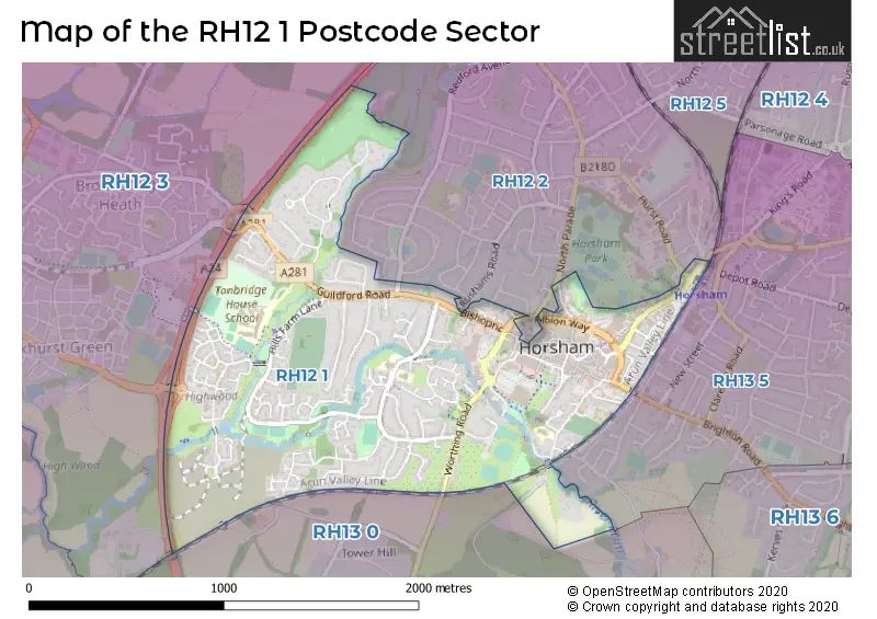
The RH12 1 Postcode shares a border with RH12 2 (HORSHAM), RH13 5 (HORSHAM), RH12 3 (Broadbridge Heath, Rudgwick, Warnham) and RH13 0 (Slinfold, Barns Green, Christs Hospital).
The sector is within the post town of HORSHAM.
RH12 1 is a postcode sector within the RH12 postcode district which is within the RH Redhill postcode area.
The Royal Mail delivery office for the RH12 1 postal sector is the Horsham Delivery Office.
The area of the RH12 1 postcode sector is 1.19 square miles which is 3.07 square kilometres or 758.69 square acres.
Waterways within the RH12 1 postcode sector include the arun, Arun.

Map of the RH12 1 Postcode Sector
Explore the RH12 1 postcode sector by using our free interactive map.
| R | H | 1 | 2 | - | 1 | X | X |
| R | H | 1 | 2 | Space | 1 | Letter | Letter |
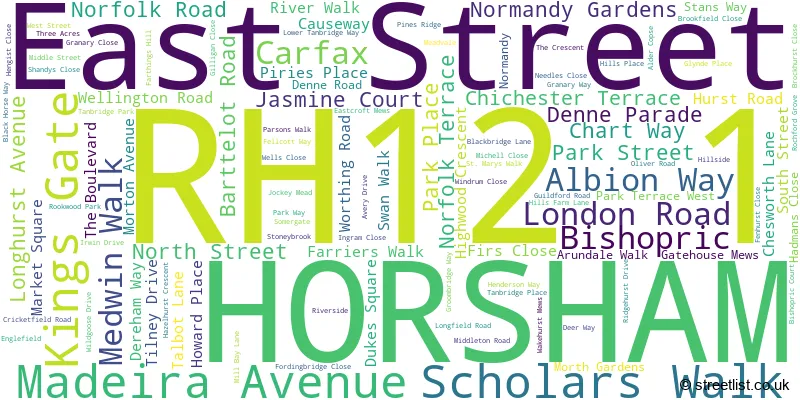
Official List of Streets
HORSHAM (107 Streets)
Unofficial Streets or Alternative Spellings
HORSHAM
DENNE PARK MERRYFIELD DRIVE NIGHTINGALE ROAD QUEEN STREET RUSHAMS ROAD SPRINGFIELD CRESCENT SPRINGFIELD PARK ROAD SPRINGFIELD ROAD ANCHOR COURT ARUNSIDE BARNES MEWS BARRACKFIELD WALK BLACK BRIDGE BLACKBRIDGE COURT COLLETTS ALLEY COPNALL WAY CRICKET FIELD ROAD CROWN ALLEY EAST MEWS FARTHINGS HILL INTERCHANGE FARTHINGS WALK FURNEAUX WALK GAOL GREEN HEWELLS COURT HILLS CEMETERY KINGS MEWS MEDWIN WAY OLD DENNE GARDENS PARKSIDE MEWS PUMP ALLEY RICHMOND MEWS RIVER MEAD SPRINGFIELD COURT ST MARYS GARDENS STANS WAY STONEBRIDGE COURT TAN BRIDGE TANFIELD COURT WAKEFIELD COURT WILD WOODSouthwater
WORTHING ROADWeather Forecast for RH12 1
Press Button to Show Forecast for Horsham
| Time Period | Icon | Description | Temperature | Rain Probability | Wind |
|---|---|---|---|---|---|
| 21:00 to 00:00 | Cloudy | 7.0°C (feels like 5.0°C) | 55.00% | ENE 7 mph |
Press Button to Show Forecast for Horsham
| Time Period | Icon | Description | Temperature | Rain Probability | Wind |
|---|---|---|---|---|---|
| 00:00 to 03:00 | Heavy rain | 7.0°C (feels like 4.0°C) | 82.00% | ENE 9 mph | |
| 03:00 to 06:00 | Light rain | 7.0°C (feels like 4.0°C) | 55.00% | NE 9 mph | |
| 06:00 to 09:00 | Overcast | 7.0°C (feels like 4.0°C) | 48.00% | ENE 9 mph | |
| 09:00 to 12:00 | Cloudy | 9.0°C (feels like 7.0°C) | 9.00% | ENE 9 mph | |
| 12:00 to 15:00 | Light rain | 12.0°C (feels like 10.0°C) | 49.00% | NE 7 mph | |
| 15:00 to 18:00 | Cloudy | 12.0°C (feels like 11.0°C) | 16.00% | NE 7 mph | |
| 18:00 to 21:00 | Heavy rain | 11.0°C (feels like 9.0°C) | 85.00% | NE 9 mph | |
| 21:00 to 00:00 | Heavy rain | 10.0°C (feels like 7.0°C) | 92.00% | NE 11 mph |
Press Button to Show Forecast for Horsham
| Time Period | Icon | Description | Temperature | Rain Probability | Wind |
|---|---|---|---|---|---|
| 00:00 to 03:00 | Heavy rain | 9.0°C (feels like 7.0°C) | 86.00% | NE 9 mph | |
| 03:00 to 06:00 | Heavy rain | 9.0°C (feels like 7.0°C) | 93.00% | ENE 7 mph | |
| 06:00 to 09:00 | Light rain | 9.0°C (feels like 7.0°C) | 57.00% | NE 7 mph | |
| 09:00 to 12:00 | Heavy rain | 9.0°C (feels like 6.0°C) | 86.00% | WNW 11 mph | |
| 12:00 to 15:00 | Overcast | 9.0°C (feels like 6.0°C) | 22.00% | WNW 13 mph | |
| 15:00 to 18:00 | Cloudy | 11.0°C (feels like 8.0°C) | 12.00% | WNW 11 mph | |
| 18:00 to 21:00 | Partly cloudy (day) | 10.0°C (feels like 8.0°C) | 9.00% | W 7 mph | |
| 21:00 to 00:00 | Clear night | 8.0°C (feels like 6.0°C) | 2.00% | SW 7 mph |
Press Button to Show Forecast for Horsham
| Time Period | Icon | Description | Temperature | Rain Probability | Wind |
|---|---|---|---|---|---|
| 00:00 to 03:00 | Clear night | 6.0°C (feels like 5.0°C) | 1.00% | SSW 4 mph | |
| 03:00 to 06:00 | Clear night | 5.0°C (feels like 3.0°C) | 1.00% | S 4 mph | |
| 06:00 to 09:00 | Sunny day | 8.0°C (feels like 6.0°C) | 1.00% | S 4 mph | |
| 09:00 to 12:00 | Partly cloudy (day) | 12.0°C (feels like 10.0°C) | 1.00% | S 9 mph | |
| 12:00 to 15:00 | Partly cloudy (day) | 13.0°C (feels like 11.0°C) | 3.00% | S 11 mph | |
| 15:00 to 18:00 | Sunny day | 13.0°C (feels like 11.0°C) | 3.00% | S 11 mph | |
| 18:00 to 21:00 | Sunny day | 12.0°C (feels like 11.0°C) | 1.00% | S 7 mph | |
| 21:00 to 00:00 | Clear night | 8.0°C (feels like 7.0°C) | 1.00% | SE 7 mph |
Press Button to Show Forecast for Horsham
| Time Period | Icon | Description | Temperature | Rain Probability | Wind |
|---|---|---|---|---|---|
| 00:00 to 03:00 | Clear night | 8.0°C (feels like 6.0°C) | 2.00% | ESE 7 mph | |
| 03:00 to 06:00 | Clear night | 8.0°C (feels like 6.0°C) | 3.00% | ESE 7 mph | |
| 06:00 to 09:00 | Sunny day | 9.0°C (feels like 8.0°C) | 5.00% | ESE 7 mph | |
| 09:00 to 12:00 | Sunny day | 14.0°C (feels like 12.0°C) | 4.00% | SE 9 mph | |
| 12:00 to 15:00 | Cloudy | 16.0°C (feels like 13.0°C) | 9.00% | SE 11 mph | |
| 15:00 to 18:00 | Cloudy | 16.0°C (feels like 14.0°C) | 9.00% | SE 9 mph | |
| 18:00 to 21:00 | Cloudy | 14.0°C (feels like 13.0°C) | 9.00% | SE 7 mph | |
| 21:00 to 00:00 | Partly cloudy (night) | 11.0°C (feels like 10.0°C) | 7.00% | ESE 7 mph |
Schools and Places of Education Within the RH12 1 Postcode Sector
Arunside School, Horsham
Community school
Blackbridge Lane, Horsham, West Sussex, RH12 1RR
Head: Mrs Donna Jagger
Ofsted Rating: Good
Inspection: 2023-09-13 (226 days ago)
Website: Visit Arunside School, Horsham Website
Phone: 01403263919
Number of Pupils: 411
St John's Catholic Primary School
Voluntary aided school
Blackbridge Lane, Horsham, West Sussex, RH12 1RR
Head: Mrs Finula Farr
Ofsted Rating: Good
Inspection: 2023-09-21 (218 days ago)
Website: Visit St John's Catholic Primary School Website
Phone: 01403265447
Number of Pupils: 202
St Mary's CofE (Aided) Primary School
Voluntary aided school
Normandy, Horsham, West Sussex, RH12 1JL
Head: Mrs Emma McLaughlin
Ofsted Rating: Good
Inspection: 2019-01-31 (1912 days ago)
Website: Visit St Mary's CofE (Aided) Primary School Website
Phone: 01403265999
Number of Pupils: 204
Tanbridge House School
Community school
Farthings Hill, Horsham, West Sussex, RH12 1SR
Head: Mr Mark Sheridan
Ofsted Rating: Outstanding
Inspection: 2012-11-23 (4172 days ago)
Website: Visit Tanbridge House School Website
Phone: 01403263628
Number of Pupils: 1525
House Prices in the RH12 1 Postcode Sector
| Type of Property | 2018 Average | 2018 Sales | 2017 Average | 2017 Sales | 2016 Average | 2016 Sales | 2015 Average | 2015 Sales |
|---|---|---|---|---|---|---|---|---|
| Detached | £559,962 | 21 | £652,399 | 23 | £660,424 | 43 | £699,868 | 42 |
| Semi-Detached | £409,052 | 27 | £378,028 | 26 | £405,833 | 36 | £391,947 | 33 |
| Terraced | £329,075 | 60 | £359,236 | 54 | £347,924 | 102 | £285,689 | 85 |
| Flats | £249,485 | 119 | £255,999 | 135 | £240,239 | 131 | £204,405 | 117 |
Important Postcodes RH12 1 in the Postcode Sector
RH12 1AH is the postcode for The y Centre, Albion Way
RH12 1AT is the postcode for The Courtyard Surgery, The Courtyard, London Road
RH12 1BG is the postcode for The Park Surgery, Albion Way, and Park Surgery, Albion Way
RH12 1DT is the postcode for Saxon Weald Homes Ltd, Saxon Weald House, 38-42 Worthing Road
RH12 1EA is the postcode for Royal Mail, Horsham Delivery Office, Hurst Road
RH12 1HE is the postcode for Horsham Museum, 9 Causeway
RH12 1HN is the postcode for Jobcentre Plus, Marlborough House, 50 East Street
RH12 1JF is the postcode for Drill Hall, Denne Road
RH12 1JL is the postcode for St. Marys Primary School, Normandy
RH12 1JW is the postcode for Southern Housing Group, Spire Court, Albion Way
RH12 1PJ is the postcode for West Sussex County Council, Horsham Library, Lower Tanbridge Way, and The Orchard Surgery, Lower Tanbridge Way
RH12 1RD is the postcode for On-Line House, 50-56 North Street
RH12 1RG is the postcode for Horsham District Council, The Capitol, North Street, and The Capitol, North Street
RH12 1RJ is the postcode for Horsham & Chanctonbury Primary Care Trust, New Park House, North Street, and New Park House, North Street
RH12 1RL is the postcode for Horsham District Council, North Point, North Street, and Park North, North Street
RH12 1RR is the postcode for Arunside Primary School, Blackbridge Lane, and St. Johns Catholic Primary School, Blackbridge Lane
RH12 1RS is the postcode for Family & Youth Centre, Three Acres
RH12 1SR is the postcode for BLOCK D DT BLOCK, Tanbridge House School, Guildford Road, Farthings Hill, BLOCK C SCIENCE, Tanbridge House School, Guildford Road, Farthings Hill, Tanbridge House School, Guildford Road, Farthings Hill, BLOCK E SPORTS HALL, Tanbridge House School, Guildford Road, Farthings Hill, ENGLISH BLOCK, Tanbridge House School, Guildford Road, Farthings Hill, BLOCK B RIVERSIDE, Tanbridge House School, Guildford Road, Farthings Hill, GEOGRAPHY BUILDING, Tanbridge House School, Guildford Road, Farthings Hill, and BLOCK A MAIN HALL, Tanbridge House School, Guildford Road, Farthings Hill
RH12 1XA is the postcode for County Hall North, Chart Way
RH12 1XH is the postcode for West Sussex County Council, Parkside, and West Sussex County Council, Parkside, Chart Way
| The RH12 1 Sector is within these Local Authorities |
|
|---|---|
| The RH12 1 Sector is within these Counties |
|
| The RH12 1 Sector is within these Water Company Areas |
|
Tourist Attractions within the RH12 1 Postcode Area
We found 1 visitor attractions within the RH12 postcode area
| Horsham Visitor Information Centre |
|---|
| Visitor Centres |
| Heritage / Visitor Centre |
| View Horsham Visitor Information Centre on Google Maps |