The RH3 postcode district is a postal district located in the RH Redhill postcode area with a population of 4,228 residents according to the 2021 England and Wales Census.
The area of the RH3 postcode district is 7.18 square miles which is 18.59 square kilometres or 4,592.72 acres.
Currently, the RH3 district has about 143 postcode units spread across 1 geographic postcode sectors.
Given that each sector allows for 400 unique postcode combinations, the district has a capacity of 400 postcodes. With 143 postcodes already in use, this leaves 257 units available.
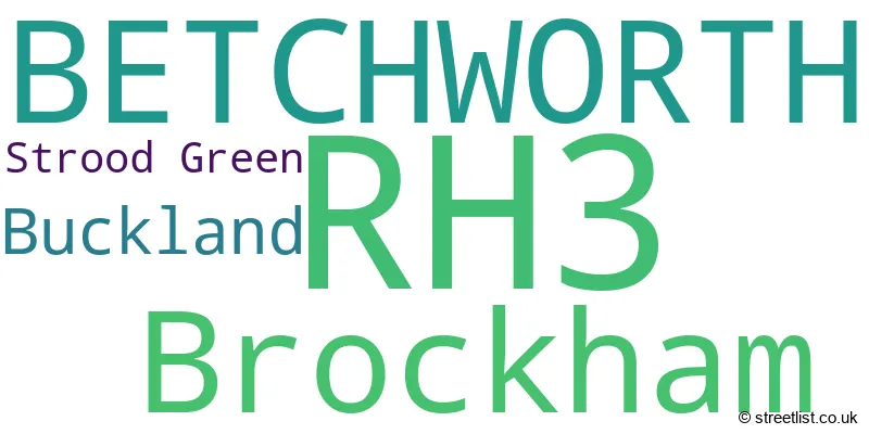
The largest settlement in the RH3 postal code is Brockham followed by BETCHWORTH, and BUCKLAND.
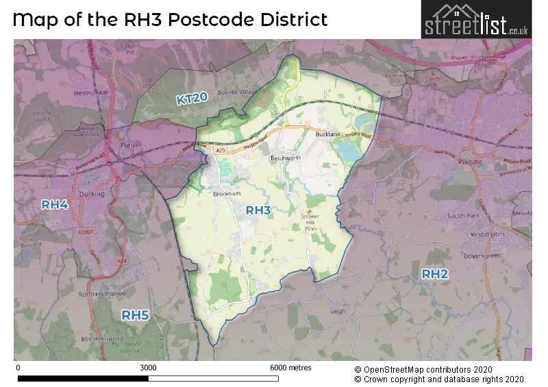
The RH3 Postcode shares a border with KT20 (TADWORTH, KINGSWOOD, LOWER KINGSWOOD), RH2 (REIGATE, Leigh, Sidlow), RH4 (DORKING, Westcott, Pixham) and RH5 (Newdigate, Beare Green, North Holmwood).
The primary settlement in the RH3 postcode district is Betchworth, located in the county of Surrey in England. Other significant settlements in this area include Brockham, Buckland, and Strood Green. The main post town in the RH3 postcode district is Betchworth.
For the district RH3, we have data on 1 postcode sectors. Here's a breakdown: The sector RH3 7, covers Betchworth and Brockham and Buckland in Surrey.
RH3 Postcode Sectors

Map of the RH3 Postcode District
Explore the RH3 postcode district by using our free interactive map.
When it comes to local government, postal geography often disregards political borders. However, for a breakdown in the RH3 District: the district mostly encompasses the Mole Valley District area with a total of 145 postcodes.
Recent House Sales in RH3
| Date | Price | Address |
|---|---|---|
| 22/09/2023 | £620,000 | The Walled Garden, Betchworth, RH3 7DH |
| 18/09/2023 | £1,000,000 | Brockham Green, Brockham, Betchworth, RH3 7JJ |
| 31/08/2023 | £1,765,000 | Pebble Hill Road, Betchworth, RH3 7BP |
| 29/08/2023 | £575,000 | Nutwood Avenue, Brockham, Betchworth, RH3 7LT |
| 23/08/2023 | £650,000 | Hillside Gardens, Brockham, Betchworth, RH3 7EW |
| 28/07/2023 | £663,500 | Rykens Lane, Betchworth, RH3 7AB |
| 27/07/2023 | £2,100,000 | Wheelers Lane, Brockham, Betchworth, RH3 7HJ |
| 21/07/2023 | £601,000 | The Coombe, Betchworth, RH3 7BU |
| 17/07/2023 | £625,000 | Bishops Cottages, Betchworth, RH3 7HA |
| 13/07/2023 | £535,000 | Oakdene Close, Brockham, Betchworth, RH3 7JZ |
Weather Forecast for RH3
Press Button to Show Forecast for Dorking
| Time Period | Icon | Description | Temperature | Rain Probability | Wind |
|---|---|---|---|---|---|
| 03:00 to 06:00 | Clear night | 6.0°C (feels like 4.0°C) | 0.00% | SSW 7 mph | |
| 06:00 to 09:00 | Sunny day | 8.0°C (feels like 6.0°C) | 0.00% | S 9 mph | |
| 09:00 to 12:00 | Partly cloudy (day) | 12.0°C (feels like 9.0°C) | 0.00% | SSW 13 mph | |
| 12:00 to 15:00 | Partly cloudy (day) | 14.0°C (feels like 10.0°C) | 1.00% | SSW 16 mph | |
| 15:00 to 18:00 | Partly cloudy (day) | 14.0°C (feels like 11.0°C) | 0.00% | SSW 16 mph | |
| 18:00 to 21:00 | Sunny day | 12.0°C (feels like 11.0°C) | 0.00% | S 9 mph | |
| 21:00 to 00:00 | Clear night | 9.0°C (feels like 7.0°C) | 0.00% | SSE 7 mph |
Press Button to Show Forecast for Dorking
| Time Period | Icon | Description | Temperature | Rain Probability | Wind |
|---|---|---|---|---|---|
| 00:00 to 03:00 | Clear night | 8.0°C (feels like 6.0°C) | 0.00% | SE 7 mph | |
| 03:00 to 06:00 | Clear night | 6.0°C (feels like 4.0°C) | 0.00% | SE 7 mph | |
| 06:00 to 09:00 | Sunny day | 8.0°C (feels like 6.0°C) | 0.00% | SE 7 mph | |
| 09:00 to 12:00 | Sunny day | 14.0°C (feels like 12.0°C) | 1.00% | SSE 9 mph | |
| 12:00 to 15:00 | Partly cloudy (day) | 16.0°C (feels like 14.0°C) | 3.00% | SSE 11 mph | |
| 15:00 to 18:00 | Cloudy | 15.0°C (feels like 13.0°C) | 10.00% | SSE 11 mph | |
| 18:00 to 21:00 | Sunny day | 14.0°C (feels like 13.0°C) | 5.00% | SSE 7 mph | |
| 21:00 to 00:00 | Partly cloudy (night) | 11.0°C (feels like 10.0°C) | 7.00% | SE 7 mph |
Press Button to Show Forecast for Dorking
| Time Period | Icon | Description | Temperature | Rain Probability | Wind |
|---|---|---|---|---|---|
| 00:00 to 03:00 | Cloudy | 10.0°C (feels like 9.0°C) | 8.00% | SSE 4 mph | |
| 03:00 to 06:00 | Partly cloudy (night) | 9.0°C (feels like 8.0°C) | 5.00% | S 4 mph | |
| 06:00 to 09:00 | Cloudy | 9.0°C (feels like 9.0°C) | 10.00% | N 2 mph | |
| 09:00 to 12:00 | Cloudy | 12.0°C (feels like 12.0°C) | 10.00% | N 4 mph | |
| 12:00 to 15:00 | Cloudy | 15.0°C (feels like 14.0°C) | 16.00% | NE 4 mph | |
| 15:00 to 18:00 | Cloudy | 15.0°C (feels like 14.0°C) | 17.00% | NNE 7 mph | |
| 18:00 to 21:00 | Cloudy | 14.0°C (feels like 13.0°C) | 20.00% | N 7 mph | |
| 21:00 to 00:00 | Cloudy | 12.0°C (feels like 11.0°C) | 19.00% | W 4 mph |
Press Button to Show Forecast for Dorking
| Time Period | Icon | Description | Temperature | Rain Probability | Wind |
|---|---|---|---|---|---|
| 00:00 to 03:00 | Light rain | 11.0°C (feels like 10.0°C) | 52.00% | NW 7 mph | |
| 03:00 to 06:00 | Light rain | 10.0°C (feels like 9.0°C) | 46.00% | NW 7 mph | |
| 06:00 to 09:00 | Light rain | 10.0°C (feels like 9.0°C) | 46.00% | WNW 7 mph | |
| 09:00 to 12:00 | Overcast | 12.0°C (feels like 11.0°C) | 17.00% | WNW 7 mph | |
| 12:00 to 15:00 | Cloudy | 15.0°C (feels like 14.0°C) | 11.00% | NW 9 mph | |
| 15:00 to 18:00 | Cloudy | 17.0°C (feels like 15.0°C) | 12.00% | NW 9 mph | |
| 18:00 to 21:00 | Partly cloudy (day) | 16.0°C (feels like 15.0°C) | 9.00% | NW 7 mph | |
| 21:00 to 00:00 | Partly cloudy (night) | 14.0°C (feels like 12.0°C) | 5.00% | NW 9 mph |
Where is the RH3 Postcode District?
The RH3 postcode district is located in Betchworth, which is a town in Surrey. Betchworth is surrounded by several nearby towns. To the northwest is Brockham, located approximately 0.77 miles away, while to the northeast is Buckland, located roughly 1.49 miles away. Boxhill is situated to the north and is approximately 1.70 miles away. Reigate Heath is to the east, around 1.88 miles away. The town of Dorking is located to the west and is approximately 3.61 miles away. Furthermore, the RH3 postcode district is situated about 20 miles from the center of London.
The district is within the post town of BETCHWORTH.
The sector has postcodes within the nation of England.
The RH3 Postcode District is in the East Surrey region of Surrey, East and West Sussex within the South East (England).
Postcode Sectors within the RH3 District
| Postcode Sector | Delivery Office |
|---|---|
| RH3 7 | Dorking Delivery Office |
| R | H | 3 | - | X | X | X |
| R | H | 3 | Space | Numeric | Letter | Letter |
Current Monthly Rental Prices
| # Bedrooms | Min Price | Max Price | Avg Price |
|---|---|---|---|
| £451 | £451 | £451 | |
| 2 | £1,600 | £1,600 | £1,600 |
| 3 | £2,300 | £2,300 | £2,300 |
Current House Prices
| # Bedrooms | Min Price | Max Price | Avg Price |
|---|---|---|---|
| 2 | £297,000 | £775,000 | £486,417 |
| 3 | £550,000 | £775,000 | £629,375 |
| 4 | £625,000 | £1,700,000 | £1,072,778 |
| 5 | £1,425,000 | £3,950,000 | £2,687,500 |
| 6 | £1,400,000 | £2,350,000 | £1,875,000 |
Estate Agents who Operate in the RH3 District
| Logo | Name | Brand Name | Address | Contact Number | Total Properties |
|---|---|---|---|---|---|
 | Dorking | Seymours Estate Agents | Cummins House, 62 South Street, Dorking, Surrey, RH4 2HD | 01306 773813 | 8 |
 | Dorking | Hamptons Sales | 251 High Street, Dorking, RH4 1YA | 01306 773811 | 3 |
 | Dorking | Jackson-Stops | 279 High Street, Dorking, RH4 1RL | 01306 776303 | 3 |
 | Dorking | White & Sons | 104 High Street Dorking Surrey RH4 1AZ | 01306 771694 | 2 |
 | UK | Clarion Housing (Lettings) | Level 6, More London Place, London, SE1 2DA | 020 3370 7544 | 2 |
| Type of Property | 2018 Average | 2018 Sales | 2017 Average | 2017 Sales | 2016 Average | 2016 Sales | 2015 Average | 2015 Sales |
|---|---|---|---|---|---|---|---|---|
| Detached | £1,000,616 | 20 | £828,548 | 21 | £943,971 | 17 | £765,397 | 34 |
| Semi-Detached | £497,176 | 17 | £486,175 | 20 | £517,159 | 23 | £531,205 | 12 |
| Terraced | £561,715 | 10 | £490,000 | 8 | £521,054 | 14 | £522,800 | 20 |
| Flats | £512,250 | 2 | £408,600 | 5 | £428,750 | 4 | £338,700 | 5 |