The RH2 postcode district is a postal district located in the RH Redhill postcode area with a population of 27,631 residents according to the 2021 England and Wales Census.
The area of the RH2 postcode district is 16.19 square miles which is 41.94 square kilometres or 10,363.65 acres.
Currently, the RH2 district has about 836 postcode units spread across 8 geographic postcode sectors.
Given that each sector allows for 400 unique postcode combinations, the district has a capacity of 3,200 postcodes. With 836 postcodes already in use, this leaves 2364 units available.
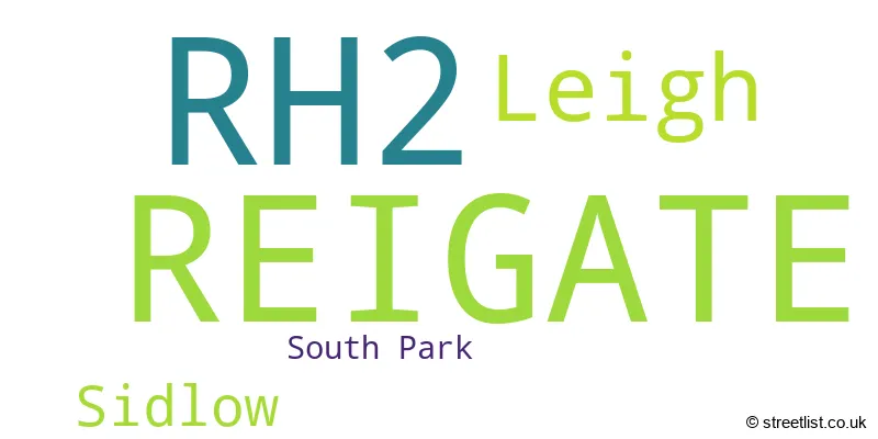
The largest settlement in the RH2 postal code is REIGATE followed by Leigh, and Sidlow.
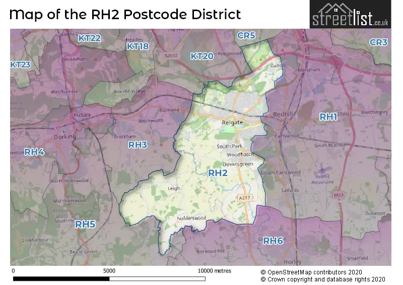
The RH2 Postcode shares a border with KT20 (TADWORTH, KINGSWOOD, LOWER KINGSWOOD), RH1 (REDHILL, MERSTHAM, BLETCHINGLEY), RH3 (Brockham, BETCHWORTH, BUCKLAND), RH5 (Newdigate, Beare Green, North Holmwood) and RH6 (HORLEY, Smallfield, London Gatwick Airport).
The RH2 postcode district in Surrey, England is primarily represented by the settlement of Reigate. Other significant settlements in this district include Leigh and Sidlow. The most significant post town in RH2 is Reigate.
For the district RH2, we have data on 5 postcode sectors. Here's a breakdown: The sector RH2 0, covers Reigate in Surrey. The sector RH2 2 is non-geographic. It's often designated for PO Boxes, large organisations, or special services. The sector RH2 7, covers Reigate in Surrey. The sector RH2 8, covers Reigate and Leigh in Surrey. The sector RH2 9, covers Reigate in Surrey.

Map of the RH2 Postcode District
Explore the RH2 postcode district by using our free interactive map.
When it comes to local government, postal geography often disregards political borders. However, for a breakdown in the RH2 District: the district mostly encompasses the Reigate and Banstead District (B) (818 postcodes), and finally, the Mole Valley District area (37 postcodes).
Recent House Sales in RH2
| Date | Price | Address |
|---|---|---|
| 27/10/2023 | £713,000 | Durfold Drive, Reigate, RH2 0QA |
| 09/10/2023 | £680,000 | Nutley Lane, Reigate, RH2 9EF |
| 04/10/2023 | £830,000 | Howard Road, Reigate, RH2 7JE |
| 03/10/2023 | £575,000 | Wray Park Road, Reigate, RH2 0US |
| 12/09/2023 | £295,000 | Kingsley Grove, Reigate, RH2 8DU |
| 08/09/2023 | £170,000 | Lesbourne Road, Reigate, RH2 7LD |
| 08/09/2023 | £500,000 | Upper West Street, Reigate, RH2 9HX |
| 07/09/2023 | £447,000 | Wilmots Close, Reigate, RH2 0NP |
| 05/09/2023 | £265,000 | Alders Road, Reigate, RH2 0ED |
| 01/09/2023 | £1,300,000 | Alma Road, Reigate, RH2 0DA |
Weather Forecast for RH2
Press Button to Show Forecast for Reigate
| Time Period | Icon | Description | Temperature | Rain Probability | Wind |
|---|---|---|---|---|---|
| 09:00 to 12:00 | Overcast | 8.0°C (feels like 6.0°C) | 13.00% | ENE 9 mph | |
| 12:00 to 15:00 | Cloudy | 11.0°C (feels like 10.0°C) | 13.00% | ENE 7 mph | |
| 15:00 to 18:00 | Cloudy | 12.0°C (feels like 11.0°C) | 47.00% | NE 7 mph | |
| 18:00 to 21:00 | Light rain | 11.0°C (feels like 9.0°C) | 61.00% | NE 9 mph | |
| 21:00 to 00:00 | Heavy rain | 9.0°C (feels like 7.0°C) | 89.00% | NE 11 mph |
Press Button to Show Forecast for Reigate
| Time Period | Icon | Description | Temperature | Rain Probability | Wind |
|---|---|---|---|---|---|
| 00:00 to 03:00 | Heavy rain | 9.0°C (feels like 6.0°C) | 90.00% | NNE 11 mph | |
| 03:00 to 06:00 | Heavy rain | 8.0°C (feels like 6.0°C) | 90.00% | NNE 9 mph | |
| 06:00 to 09:00 | Heavy rain | 8.0°C (feels like 6.0°C) | 85.00% | NE 7 mph | |
| 09:00 to 12:00 | Heavy rain | 9.0°C (feels like 6.0°C) | 78.00% | W 9 mph | |
| 12:00 to 15:00 | Light rain | 9.0°C (feels like 7.0°C) | 56.00% | W 13 mph | |
| 15:00 to 18:00 | Cloudy | 10.0°C (feels like 8.0°C) | 19.00% | W 11 mph | |
| 18:00 to 21:00 | Cloudy | 10.0°C (feels like 8.0°C) | 8.00% | WSW 7 mph | |
| 21:00 to 00:00 | Clear night | 8.0°C (feels like 6.0°C) | 4.00% | WSW 7 mph |
Press Button to Show Forecast for Reigate
| Time Period | Icon | Description | Temperature | Rain Probability | Wind |
|---|---|---|---|---|---|
| 00:00 to 03:00 | Clear night | 6.0°C (feels like 5.0°C) | 2.00% | SSW 7 mph | |
| 03:00 to 06:00 | Clear night | 5.0°C (feels like 4.0°C) | 1.00% | SSW 4 mph | |
| 06:00 to 09:00 | Sunny day | 7.0°C (feels like 5.0°C) | 1.00% | S 4 mph | |
| 09:00 to 12:00 | Cloudy | 11.0°C (feels like 9.0°C) | 7.00% | S 9 mph | |
| 12:00 to 15:00 | Partly cloudy (day) | 13.0°C (feels like 11.0°C) | 5.00% | S 11 mph | |
| 15:00 to 18:00 | Partly cloudy (day) | 14.0°C (feels like 11.0°C) | 4.00% | S 11 mph | |
| 18:00 to 21:00 | Sunny day | 12.0°C (feels like 11.0°C) | 4.00% | S 7 mph | |
| 21:00 to 00:00 | Clear night | 9.0°C (feels like 7.0°C) | 1.00% | SE 7 mph |
Press Button to Show Forecast for Reigate
| Time Period | Icon | Description | Temperature | Rain Probability | Wind |
|---|---|---|---|---|---|
| 00:00 to 03:00 | Clear night | 8.0°C (feels like 6.0°C) | 1.00% | SE 7 mph | |
| 03:00 to 06:00 | Clear night | 8.0°C (feels like 6.0°C) | 4.00% | SE 7 mph | |
| 06:00 to 09:00 | Sunny day | 9.0°C (feels like 7.0°C) | 6.00% | SE 7 mph | |
| 09:00 to 12:00 | Partly cloudy (day) | 13.0°C (feels like 12.0°C) | 5.00% | SE 9 mph | |
| 12:00 to 15:00 | Cloudy | 15.0°C (feels like 13.0°C) | 12.00% | SE 11 mph | |
| 15:00 to 18:00 | Cloudy | 16.0°C (feels like 14.0°C) | 11.00% | SE 9 mph | |
| 18:00 to 21:00 | Cloudy | 14.0°C (feels like 13.0°C) | 10.00% | SE 7 mph | |
| 21:00 to 00:00 | Cloudy | 12.0°C (feels like 11.0°C) | 9.00% | ESE 7 mph |
Where is the RH2 Postcode District?
The data indicates that the postcode district RH2 is located in the town of Reigate. Reigate is situated near other towns such as Reigate Heath, Buckland, Betchworth, Redhill, and South Nutfield. Additionally, Reigate is approximately 20.17 miles away from the center of London.
The district is within the post town of REIGATE.
The sector has postcodes within the nation of England.
The RH2 Postcode District is in the East Surrey region of Surrey, East and West Sussex within the South East (England).
| Postcode Sector | Delivery Office |
|---|---|
| RH2 0 | Reigate Delivery Office |
| RH2 7 | Reigate Delivery Office |
| RH2 8 | Reigate Delivery Office |
| RH2 9 | Reigate Delivery Office |
| R | H | 2 | - | X | X | X |
| R | H | 2 | Space | Numeric | Letter | Letter |
Current Monthly Rental Prices
| # Bedrooms | Min Price | Max Price | Avg Price |
|---|---|---|---|
| £695 | £695 | £695 | |
| 1 | £1,050 | £1,400 | £1,253 |
| 2 | £1,325 | £2,000 | £1,582 |
| 4 | £2,500 | £3,300 | £2,800 |
| 5 | £5,500 | £5,500 | £5,500 |
Current House Prices
| # Bedrooms | Min Price | Max Price | Avg Price |
|---|---|---|---|
| £170,000 | £1,500,000 | £835,000 | |
| 1 | £90,000 | £403,950 | £238,411 |
| 2 | £140,000 | £800,000 | £397,402 |
| 3 | £264,000 | £1,450,000 | £637,835 |
| 4 | £550,000 | £2,000,000 | £969,426 |
| 5 | £479,000 | £2,625,000 | £1,392,316 |
| 6 | £2,250,000 | £3,250,000 | £2,666,667 |
Estate Agents who Operate in the RH2 District
| Logo | Name | Brand Name | Address | Contact Number | Total Properties |
|---|---|---|---|---|---|
 | Reigate | Cubitt & West | 30 Church Street, Reigate, Surrey, RH2 0AJ | 01737 301436 | 39 |
 | Reigate | White & Sons | 24 High Street Reigate Surrey RH2 9AY | 01737 302054 | 27 |
 | Reigate | Halliwell Marks | 4a High Street Reigate RH2 9AY | 01737 301402 | 23 |
 | Reigate | Robert Leech Estate Agents | 1-3 High Street, Reigate, RH2 9AA | 01737 949513 | 18 |
 | Reigate | Jackson Stops | 14 Bell Street, Reigate, RH2 7BE | 01737 302156 | 16 |
| Type of Property | 2018 Average | 2018 Sales | 2017 Average | 2017 Sales | 2016 Average | 2016 Sales | 2015 Average | 2015 Sales |
|---|---|---|---|---|---|---|---|---|
| Detached | £944,429 | 104 | £944,044 | 121 | £969,622 | 98 | £880,950 | 125 |
| Semi-Detached | £566,978 | 104 | £548,237 | 108 | £521,741 | 124 | £499,185 | 130 |
| Terraced | £449,077 | 78 | £485,994 | 69 | £439,660 | 69 | £459,382 | 109 |
| Flats | £291,649 | 108 | £334,776 | 176 | £299,765 | 183 | £274,947 | 191 |