The RH6 postcode district is a postal district located in the RH Redhill postcode area with a population of 35,061 residents according to the 2021 England and Wales Census.
The area of the RH6 postcode district is 22.57 square miles which is 58.46 square kilometres or 14,446.69 acres.
Currently, the RH6 district has about 874 postcode units spread across 4 geographic postcode sectors.
Given that each sector allows for 400 unique postcode combinations, the district has a capacity of 1,600 postcodes. With 874 postcodes already in use, this leaves 726 units available.
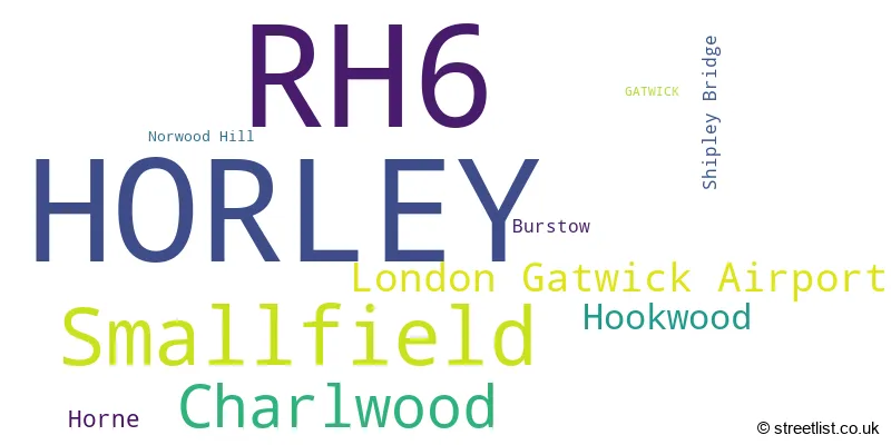
The largest settlement in the RH6 postal code is HORLEY followed by Smallfield, and London Gatwick Airport.
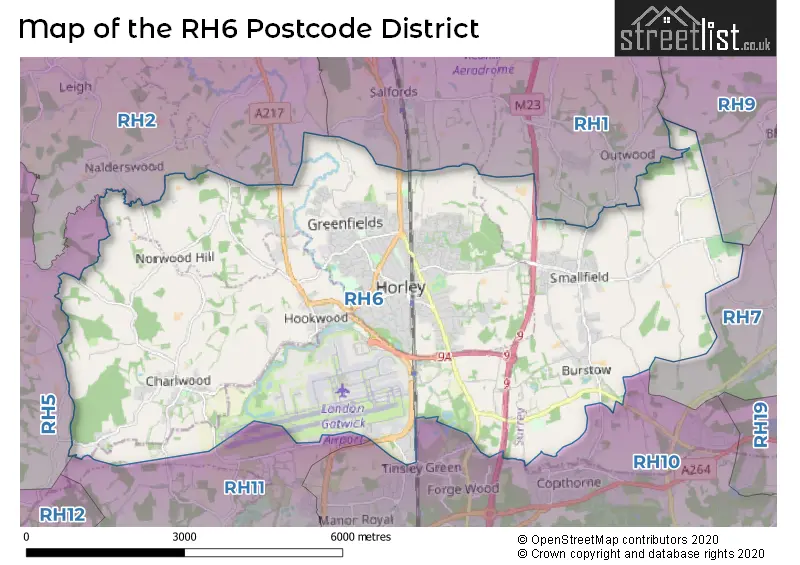
The RH6 Postcode shares a border with RH11 (CRAWLEY, Ifield, Pease Pottage), RH1 (REDHILL, MERSTHAM, BLETCHINGLEY), RH10 (CRAWLEY, Maidenbower, Copthorne), RH2 (REIGATE, Leigh, Sidlow) and RH5 (Newdigate, Beare Green, North Holmwood).
The primary settlement in the RH6 postcode district is Horley, located in Surrey. The most significant post town in this district is Gatwick, which is also located in Surrey. There are also other significant settlements within the district, including Charlwood, Hookwood, Norwood Hill, Burstow, Horne, Shipley Bridge, and Smallfield. These settlements are all located in Surrey, except for Horley and Shipley Bridge, which are also located in West Sussex.
For the district RH6, we have data on 5 postcode sectors. Here's a breakdown: The sector RH6 0, covers Charlwood and Hookwood and Horley in Surrey. The sector RH6 0, covers London Gatwick Airport in West Sussex. The sector RH6 6 is non-geographic. It's often designated for PO Boxes, large organisations, or special services. The sector RH6 7, covers Horley in Surrey. The sector RH6 8, covers Horley in Surrey. The sector RH6 9, covers Horley and Smallfield in Surrey.

Map of the RH6 Postcode District
Explore the RH6 postcode district by using our free interactive map.
When it comes to local government, postal geography often disregards political borders. However, for a breakdown in the RH6 District: the district mostly encompasses the Reigate and Banstead District (B) (676 postcodes), followed by the Tandridge District area (101 postcodes), followed by the Mole Valley District area (73 postcodes), and finally, the Crawley District (B) area (48 postcodes).
Recent House Sales in RH6
| Date | Price | Address |
|---|---|---|
| 25/10/2023 | £506,000 | Bayhorne Lane, Horley, RH6 9ES |
| 05/10/2023 | £475,000 | Glovers Road, Charlwood, Horley, RH6 0EH |
| 02/10/2023 | £410,000 | Blundell Avenue, Horley, RH6 8AY |
| 28/09/2023 | £425,000 | Forge Place, Horley, RH6 0AL |
| 25/09/2023 | £605,000 | Landen Park, Horley, RH6 8DZ |
| 21/09/2023 | £455,000 | Peppiatt Close, Horley, RH6 9FR |
| 14/09/2023 | £290,000 | Russells Crescent, Horley, RH6 7GW |
| 14/09/2023 | £591,000 | Rosemary Lane, Horley, RH6 9HG |
| 08/09/2023 | £420,000 | Lee Street, Horley, RH6 8EQ |
| 01/09/2023 | £140,000 | Yattendon Road, Horley, RH6 7BS |
Where is the RH6 Postcode District?
The data indicates that the specified postcode district, RH6, is located in the town of Horley. Horley is a district town near several other towns, including Crawley to the south, South Nutfield to the north, Reigate Heath to the northwest, and Bletchingley to the northeast. Additionally, Horley is approximately 23.5 miles away from the center of London.
The district covers the post towns of HORLEY.
The sector has postcodes within the nation of England.
The RH6 Postcode District is covers the following regions.
- West Sussex (North East) - Surrey, East and West Sussex - South East (England)
- East Surrey - Surrey, East and West Sussex - South East (England)
Weather Forecast for RH6
Press Button to Show Forecast for Horley
| Time Period | Icon | Description | Temperature | Rain Probability | Wind |
|---|---|---|---|---|---|
| 15:00 to 18:00 | Partly cloudy (day) | 23.0°C (feels like 21.0°C) | 0.00% | SE 9 mph | |
| 18:00 to 21:00 | Sunny day | 20.0°C (feels like 18.0°C) | 0.00% | E 11 mph | |
| 21:00 to 00:00 | Clear night | 15.0°C (feels like 14.0°C) | 0.00% | ENE 9 mph |
Press Button to Show Forecast for Horley
| Time Period | Icon | Description | Temperature | Rain Probability | Wind |
|---|---|---|---|---|---|
| 00:00 to 03:00 | Partly cloudy (night) | 14.0°C (feels like 13.0°C) | 1.00% | E 9 mph | |
| 03:00 to 06:00 | Cloudy | 14.0°C (feels like 13.0°C) | 4.00% | E 7 mph | |
| 06:00 to 09:00 | Cloudy | 15.0°C (feels like 14.0°C) | 4.00% | E 7 mph | |
| 09:00 to 12:00 | Partly cloudy (day) | 20.0°C (feels like 19.0°C) | 2.00% | ESE 7 mph | |
| 12:00 to 15:00 | Partly cloudy (day) | 23.0°C (feels like 22.0°C) | 2.00% | SE 9 mph | |
| 15:00 to 18:00 | Partly cloudy (day) | 23.0°C (feels like 22.0°C) | 4.00% | S 9 mph | |
| 18:00 to 21:00 | Cloudy | 20.0°C (feels like 18.0°C) | 8.00% | S 9 mph | |
| 21:00 to 00:00 | Cloudy | 15.0°C (feels like 14.0°C) | 17.00% | SSW 7 mph |
Press Button to Show Forecast for Horley
| Time Period | Icon | Description | Temperature | Rain Probability | Wind |
|---|---|---|---|---|---|
| 00:00 to 03:00 | Cloudy | 13.0°C (feels like 12.0°C) | 18.00% | SSW 7 mph | |
| 03:00 to 06:00 | Overcast | 12.0°C (feels like 11.0°C) | 14.00% | S 7 mph | |
| 06:00 to 09:00 | Overcast | 13.0°C (feels like 11.0°C) | 13.00% | SSW 9 mph | |
| 09:00 to 12:00 | Overcast | 15.0°C (feels like 13.0°C) | 16.00% | S 11 mph | |
| 12:00 to 15:00 | Overcast | 16.0°C (feels like 13.0°C) | 18.00% | S 16 mph | |
| 15:00 to 18:00 | Light rain | 17.0°C (feels like 14.0°C) | 51.00% | S 16 mph | |
| 18:00 to 21:00 | Heavy rain | 15.0°C (feels like 13.0°C) | 79.00% | SSE 13 mph | |
| 21:00 to 00:00 | Heavy rain | 14.0°C (feels like 12.0°C) | 85.00% | SSE 11 mph |
Press Button to Show Forecast for Horley
| Time Period | Icon | Description | Temperature | Rain Probability | Wind |
|---|---|---|---|---|---|
| 00:00 to 03:00 | Heavy rain | 14.0°C (feels like 12.0°C) | 84.00% | SSE 11 mph | |
| 03:00 to 06:00 | Heavy rain | 13.0°C (feels like 12.0°C) | 82.00% | S 9 mph | |
| 06:00 to 09:00 | Light rain | 13.0°C (feels like 11.0°C) | 62.00% | S 9 mph | |
| 09:00 to 12:00 | Light rain shower (day) | 14.0°C (feels like 12.0°C) | 47.00% | S 11 mph | |
| 12:00 to 15:00 | Light rain shower (day) | 15.0°C (feels like 13.0°C) | 41.00% | S 13 mph | |
| 15:00 to 18:00 | Light rain shower (day) | 16.0°C (feels like 13.0°C) | 32.00% | S 16 mph | |
| 18:00 to 21:00 | Light rain shower (day) | 15.0°C (feels like 13.0°C) | 31.00% | S 11 mph | |
| 21:00 to 00:00 | Partly cloudy (night) | 13.0°C (feels like 11.0°C) | 5.00% | SSE 9 mph |
Press Button to Show Forecast for Horley
| Time Period | Icon | Description | Temperature | Rain Probability | Wind |
|---|---|---|---|---|---|
| 00:00 to 03:00 | Cloudy | 12.0°C (feels like 10.0°C) | 8.00% | S 9 mph | |
| 03:00 to 06:00 | Partly cloudy (night) | 11.0°C (feels like 9.0°C) | 7.00% | S 9 mph | |
| 06:00 to 09:00 | Cloudy | 12.0°C (feels like 10.0°C) | 10.00% | S 11 mph | |
| 09:00 to 12:00 | Light rain shower (day) | 14.0°C (feels like 11.0°C) | 35.00% | S 13 mph | |
| 12:00 to 15:00 | Light rain shower (day) | 15.0°C (feels like 12.0°C) | 31.00% | S 13 mph | |
| 15:00 to 18:00 | Light rain shower (day) | 16.0°C (feels like 13.0°C) | 28.00% | S 13 mph | |
| 18:00 to 21:00 | Light rain shower (day) | 15.0°C (feels like 13.0°C) | 29.00% | S 9 mph | |
| 21:00 to 00:00 | Clear night | 12.0°C (feels like 11.0°C) | 2.00% | SSE 7 mph |
| Postcode Sector | Delivery Office |
|---|---|
| RH6 0 | Horley Delivery Office |
| RH6 7 | Horley Delivery Office |
| RH6 8 | Horley Delivery Office |
| RH6 9 | Horley Delivery Office |
| R | H | 6 | - | X | X | X |
| R | H | 6 | Space | Numeric | Letter | Letter |
Current Monthly Rental Prices
| # Bedrooms | Min Price | Max Price | Avg Price |
|---|---|---|---|
| 1 | £725 | £1,300 | £1,081 |
| 2 | £850 | £1,700 | £1,375 |
| 3 | £1,500 | £2,000 | £1,800 |
| 4 | £2,750 | £2,800 | £2,775 |
| 5 | £3,300 | £3,300 | £3,300 |
Current House Prices
| # Bedrooms | Min Price | Max Price | Avg Price |
|---|---|---|---|
| £5,000 | £1,950,000 | £302,500 | |
| 1 | £100,000 | £300,000 | £195,595 |
| 2 | £110,000 | £600,000 | £285,403 |
| 3 | £119,000 | £895,000 | £500,987 |
| 4 | £325,000 | £1,450,000 | £685,253 |
| 5 | £700,000 | £2,000,000 | £1,011,538 |
| 6 | £775,000 | £2,000,000 | £1,200,833 |
| 9 | £2,000,000 | £2,000,000 | £2,000,000 |
| 11 | £1,900,000 | £1,900,000 | £1,900,000 |
Estate Agents who Operate in the RH6 District
| Logo | Name | Brand Name | Address | Contact Number | Total Properties |
|---|---|---|---|---|---|
 | Horley | Connells | 30 High Street, Horley, RH6 7BB | 01293 222731 | 36 |
 | Horley | Mansell McTaggart | 3 Central Parade, Massetts Road, Horley, RH6 7PP | 01293 222525 | 34 |
 | Horley | JamesDean Estate Agents | 66 Victoria Road, Horley, RH6 7PZ | 01293 222566 | 34 |
 | Horley | White & Sons | 3 Massetts Road Horley Surrey RH6 7PR | 01293 222479 | 27 |
 | Horley | Cubitt & West | 101 Victoria Road, Horley, Surrey, RH6 7PH | 01293 222593 | 26 |
Yearly House Price Averages for the RH6 Postcode District
| Type of Property | 2018 Average | 2018 Sales | 2017 Average | 2017 Sales | 2016 Average | 2016 Sales | 2015 Average | 2015 Sales |
|---|---|---|---|---|---|---|---|---|
| Detached | £543,047 | 196 | £524,627 | 213 | £536,678 | 201 | £508,454 | 197 |
| Semi-Detached | £393,907 | 204 | £383,167 | 181 | £371,722 | 152 | £337,999 | 178 |
| Terraced | £362,647 | 119 | £331,820 | 113 | £324,142 | 108 | £297,653 | 127 |
| Flats | £234,317 | 214 | £220,313 | 163 | £199,219 | 175 | £185,567 | 101 |