The RH6 8 postcode sector is within the county of Surrey.
Did you know? According to the 2021 Census, the RH6 8 postcode sector is home to a bustling 11,697 residents!
Given that each sector allows for 400 unique postcode combinations. Letters C, I, K, M, O and V are not allowed in the last two letters of a postcode. With 237 postcodes already in use, this leaves 163 units available.
The RH6 8 postal code covers the settlement of HORLEY.
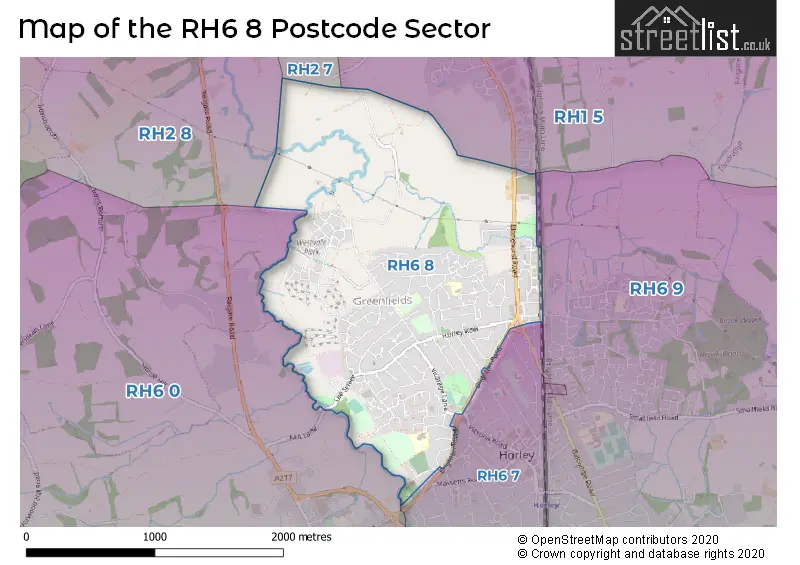
The RH6 8 Postcode shares a border with RH2 7 (REIGATE), RH6 7 (HORLEY), RH1 5 (REDHILL, South Nutfield, Outwood), RH2 8 (REIGATE, Leigh, Sidlow), RH6 0 (London Gatwick Airport, Charlwood, Hookwood) and RH6 9 (HORLEY, Smallfield, Shipley Bridge).
The sector is within the post town of HORLEY.
RH6 8 is a postcode sector within the RH6 postcode district which is within the RH Redhill postcode area.
The Royal Mail delivery office for the RH6 8 postal sector is the Horley Delivery Office.
The area of the RH6 8 postcode sector is 1.79 square miles which is 4.64 square kilometres or 1,146.92 square acres.
Waterways within the RH6 8 postcode sector include the River Mole.

Map of the RH6 8 Postcode Sector
Explore the RH6 8 postcode sector by using our free interactive map.
| R | H | 6 | - | 8 | X | X |
| R | H | 6 | Space | 8 | Letter | Letter |
Official List of Streets
HORLEY (163 Streets)
Unofficial Streets or Alternative Spellings
Maidenbower
BALCOMBE ROADHORLEY
CHATELET CLOSE THE AVENUE VICTORIA ROAD CHEQUERS ROUNDABOUT ELM TREE CLOSE ORCHARD CLOSE OVERGROWN PARK VIEW PRIESTLAND CLOSE STONY WALK YEW TREE CLOSEREDHILL
CROSS OAK LANESalfords
BONEHURST ROADHookwood
MILL LANEWeather Forecast for RH6 8
Press Button to Show Forecast for Horley
| Time Period | Icon | Description | Temperature | Rain Probability | Wind |
|---|---|---|---|---|---|
| 03:00 to 06:00 | Light rain | 7.0°C (feels like 4.0°C) | 49.00% | ENE 9 mph | |
| 06:00 to 09:00 | Overcast | 7.0°C (feels like 4.0°C) | 16.00% | NE 9 mph | |
| 09:00 to 12:00 | Overcast | 9.0°C (feels like 7.0°C) | 11.00% | ENE 9 mph | |
| 12:00 to 15:00 | Cloudy | 12.0°C (feels like 10.0°C) | 12.00% | ENE 9 mph | |
| 15:00 to 18:00 | Cloudy | 12.0°C (feels like 11.0°C) | 52.00% | ENE 9 mph | |
| 18:00 to 21:00 | Heavy rain | 11.0°C (feels like 9.0°C) | 89.00% | NE 9 mph | |
| 21:00 to 00:00 | Heavy rain | 10.0°C (feels like 7.0°C) | 91.00% | NE 11 mph |
Press Button to Show Forecast for Horley
| Time Period | Icon | Description | Temperature | Rain Probability | Wind |
|---|---|---|---|---|---|
| 00:00 to 03:00 | Heavy rain | 9.0°C (feels like 7.0°C) | 93.00% | NNE 9 mph | |
| 03:00 to 06:00 | Heavy rain | 9.0°C (feels like 7.0°C) | 92.00% | ENE 9 mph | |
| 06:00 to 09:00 | Heavy rain | 9.0°C (feels like 7.0°C) | 76.00% | SSW 7 mph | |
| 09:00 to 12:00 | Light rain | 9.0°C (feels like 7.0°C) | 59.00% | WSW 11 mph | |
| 12:00 to 15:00 | Light rain | 9.0°C (feels like 6.0°C) | 50.00% | NW 13 mph | |
| 15:00 to 18:00 | Cloudy | 10.0°C (feels like 8.0°C) | 13.00% | WNW 11 mph | |
| 18:00 to 21:00 | Light rain shower (day) | 10.0°C (feels like 8.0°C) | 38.00% | WSW 9 mph | |
| 21:00 to 00:00 | Clear night | 8.0°C (feels like 6.0°C) | 3.00% | S 7 mph |
Press Button to Show Forecast for Horley
| Time Period | Icon | Description | Temperature | Rain Probability | Wind |
|---|---|---|---|---|---|
| 00:00 to 03:00 | Clear night | 6.0°C (feels like 5.0°C) | 1.00% | SSW 4 mph | |
| 03:00 to 06:00 | Clear night | 5.0°C (feels like 4.0°C) | 1.00% | S 4 mph | |
| 06:00 to 09:00 | Sunny day | 7.0°C (feels like 6.0°C) | 4.00% | S 4 mph | |
| 09:00 to 12:00 | Cloudy | 12.0°C (feels like 10.0°C) | 4.00% | S 9 mph | |
| 12:00 to 15:00 | Partly cloudy (day) | 14.0°C (feels like 11.0°C) | 2.00% | S 11 mph | |
| 15:00 to 18:00 | Partly cloudy (day) | 14.0°C (feels like 11.0°C) | 3.00% | S 11 mph | |
| 18:00 to 21:00 | Sunny day | 13.0°C (feels like 11.0°C) | 3.00% | S 7 mph | |
| 21:00 to 00:00 | Clear night | 9.0°C (feels like 8.0°C) | 1.00% | SE 7 mph |
Press Button to Show Forecast for Horley
| Time Period | Icon | Description | Temperature | Rain Probability | Wind |
|---|---|---|---|---|---|
| 00:00 to 03:00 | Clear night | 9.0°C (feels like 7.0°C) | 2.00% | ESE 7 mph | |
| 03:00 to 06:00 | Clear night | 8.0°C (feels like 6.0°C) | 3.00% | ESE 7 mph | |
| 06:00 to 09:00 | Partly cloudy (day) | 9.0°C (feels like 7.0°C) | 6.00% | ESE 7 mph | |
| 09:00 to 12:00 | Partly cloudy (day) | 14.0°C (feels like 12.0°C) | 3.00% | SE 9 mph | |
| 12:00 to 15:00 | Cloudy | 16.0°C (feels like 13.0°C) | 8.00% | SE 11 mph | |
| 15:00 to 18:00 | Cloudy | 16.0°C (feels like 14.0°C) | 9.00% | SE 9 mph | |
| 18:00 to 21:00 | Cloudy | 14.0°C (feels like 13.0°C) | 11.00% | SE 7 mph | |
| 21:00 to 00:00 | Cloudy | 12.0°C (feels like 10.0°C) | 10.00% | ESE 7 mph |
Schools and Places of Education Within the RH6 8 Postcode Sector
Manorfield Primary and Nursery School
Community school
Sangers Drive, Horley, Surrey, RH6 8AL
Head: Mrs Nicola Jones
Ofsted Rating: Good
Inspection: 2022-11-17 (527 days ago)
Website: Visit Manorfield Primary and Nursery School Website
Phone: 01293782839
Number of Pupils: 262
Meath Green Infant School
Community school
Kiln Lane, Horley, Surrey, RH6 8JG
Head: Mrs Helen Powell
Ofsted Rating: Good
Inspection: 2022-03-16 (773 days ago)
Website: Visit Meath Green Infant School Website
Phone: 01293772708
Number of Pupils: 267
Meath Green Junior School
Community school
Greenfields Road, Horley, Surrey, RH6 8HW
Head: Serena / Patrick Beasley / Amerio
Ofsted Rating: Good
Inspection: 2019-05-09 (1815 days ago)
Website: Visit Meath Green Junior School Website
Phone: 01293784298
Number of Pupils: 356
Westvale Park Primary Academy
Free schools
Cavell Way, Horley, Surrey, RH6 8SU
Head: Mrs Susan Kelly
Ofsted Rating: Good
Inspection: 2023-06-08 (324 days ago)
Website: Visit Westvale Park Primary Academy Website
Phone: 01293365019
Number of Pupils: 215
House Prices in the RH6 8 Postcode Sector
| Type of Property | 2018 Average | 2018 Sales | 2017 Average | 2017 Sales | 2016 Average | 2016 Sales | 2015 Average | 2015 Sales |
|---|---|---|---|---|---|---|---|---|
| Detached | £513,077 | 84 | £477,939 | 95 | £446,351 | 37 | £443,998 | 24 |
| Semi-Detached | £401,339 | 112 | £379,437 | 94 | £352,942 | 44 | £338,878 | 47 |
| Terraced | £370,885 | 44 | £324,083 | 46 | £306,633 | 26 | £272,728 | 31 |
| Flats | £250,670 | 61 | £258,010 | 51 | £205,970 | 10 | £185,089 | 20 |
Important Postcodes RH6 8 in the Postcode Sector
RH6 8AL is the postcode for Manorfield Primary and Nursery School, Sangers Drive
RH6 8HW is the postcode for Meath Green Junior School, Greenfields Road, and Meath Green County Junior School, Greenfields Road
RH6 8JG is the postcode for Meath Green Infant School, Kiln Lane
RH6 8RJ is the postcode for Greenwich Leisure Ltd, Horley Anderson Sports Centre
RH6 8SP is the postcode for Horley Leisure Centre, Anderson Way
| The RH6 8 Sector is within these Local Authorities |
|
|---|---|
| The RH6 8 Sector is within these Counties |
|
| The RH6 8 Sector is within these Water Company Areas |
|