The S10 5 postcode sector is within the county of South Yorkshire.
Did you know? According to the 2021 Census, the S10 5 postcode sector is home to a bustling 8,744 residents!
Given that each sector allows for 400 unique postcode combinations. Letters C, I, K, M, O and V are not allowed in the last two letters of a postcode. With 180 postcodes already in use, this leaves 220 units available.
The S10 5 postal code covers the settlement of SHEFFIELD.
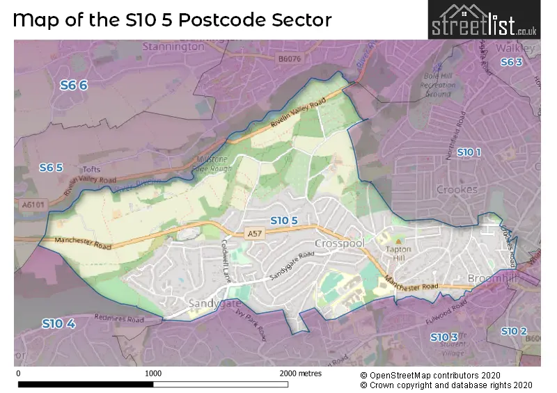
The S10 5 Postcode shares a border with S10 1 (SHEFFIELD), S6 5 (SHEFFIELD, Rivelin), S10 2 (SHEFFIELD), S10 3 (SHEFFIELD) and S10 4 (SHEFFIELD).
The sector is within the post town of SHEFFIELD.
S10 5 is a postcode sector within the S10 postcode district which is within the S Sheffield postcode area.
The Royal Mail delivery office for the S10 5 postal sector is the Sheffield Wpostal Delivery Office.
The area of the S10 5 postcode sector is 1.28 square miles which is 3.33 square kilometres or 821.72 square acres.
Waterways within the S10 5 postcode sector include the River Rivelin.

Map of the S10 5 Postcode Sector
Explore the S10 5 postcode sector by using our free interactive map.
| S | 1 | 0 | - | 5 | X | X |
| S | 1 | 0 | Space | 5 | Letter | Letter |
Official List of Streets
SHEFFIELD (91 Streets)
Unofficial Streets or Alternative Spellings
SHEFFIELD
BLAKENEY ROAD BOLE HILL ROAD CARSICK HILL ROAD CROOKES CROOKESMOOR ROAD CROSS LANE FORRES ROAD NAIRN STREET PITCHFORD LANE RANMOOR CLIFFE ROAD REDMIRES ROAD RIVELIN VALLEY ROAD SHORE LANE TETNEY ROAD WHITWORTH ROAD BACK LANE COPPICE ROAD CROSS LANE MEWS HAGG HILL LONG WALK PARKERS ROAD TAPTON WALKRivelin
MANCHESTER ROADWeather Forecast for S10 5
Press Button to Show Forecast for Ranmoor
| Time Period | Icon | Description | Temperature | Rain Probability | Wind |
|---|---|---|---|---|---|
| 15:00 to 18:00 | Overcast | 8.0°C (feels like 6.0°C) | 35.00% | NE 4 mph | |
| 18:00 to 21:00 | Cloudy | 6.0°C (feels like 4.0°C) | 8.00% | E 7 mph | |
| 21:00 to 00:00 | Cloudy | 5.0°C (feels like 3.0°C) | 9.00% | ENE 7 mph |
Press Button to Show Forecast for Ranmoor
| Time Period | Icon | Description | Temperature | Rain Probability | Wind |
|---|---|---|---|---|---|
| 00:00 to 03:00 | Cloudy | 4.0°C (feels like 2.0°C) | 4.00% | ENE 4 mph | |
| 03:00 to 06:00 | Cloudy | 3.0°C (feels like 1.0°C) | 4.00% | NNE 4 mph | |
| 06:00 to 09:00 | Cloudy | 3.0°C (feels like 1.0°C) | 6.00% | NNE 4 mph | |
| 09:00 to 12:00 | Cloudy | 6.0°C (feels like 4.0°C) | 7.00% | NE 9 mph | |
| 12:00 to 15:00 | Overcast | 8.0°C (feels like 5.0°C) | 22.00% | ENE 11 mph | |
| 15:00 to 18:00 | Overcast | 8.0°C (feels like 6.0°C) | 22.00% | ENE 9 mph | |
| 18:00 to 21:00 | Overcast | 7.0°C (feels like 4.0°C) | 14.00% | ENE 9 mph | |
| 21:00 to 00:00 | Overcast | 6.0°C (feels like 3.0°C) | 11.00% | NE 9 mph |
Press Button to Show Forecast for Ranmoor
| Time Period | Icon | Description | Temperature | Rain Probability | Wind |
|---|---|---|---|---|---|
| 00:00 to 03:00 | Cloudy | 5.0°C (feels like 2.0°C) | 6.00% | NNE 9 mph | |
| 03:00 to 06:00 | Cloudy | 5.0°C (feels like 1.0°C) | 52.00% | N 11 mph | |
| 06:00 to 09:00 | Heavy rain | 5.0°C (feels like 1.0°C) | 79.00% | N 11 mph | |
| 09:00 to 12:00 | Heavy rain | 5.0°C (feels like 2.0°C) | 80.00% | NNW 11 mph | |
| 12:00 to 15:00 | Light rain | 7.0°C (feels like 4.0°C) | 46.00% | NNW 11 mph | |
| 15:00 to 18:00 | Cloudy | 9.0°C (feels like 6.0°C) | 13.00% | WNW 11 mph | |
| 18:00 to 21:00 | Partly cloudy (day) | 9.0°C (feels like 6.0°C) | 4.00% | W 9 mph | |
| 21:00 to 00:00 | Clear night | 6.0°C (feels like 3.0°C) | 2.00% | WSW 7 mph |
Press Button to Show Forecast for Ranmoor
| Time Period | Icon | Description | Temperature | Rain Probability | Wind |
|---|---|---|---|---|---|
| 00:00 to 03:00 | Clear night | 5.0°C (feels like 2.0°C) | 1.00% | SW 7 mph | |
| 03:00 to 06:00 | Clear night | 3.0°C (feels like 0.0°C) | 1.00% | SW 7 mph | |
| 06:00 to 09:00 | Sunny day | 5.0°C (feels like 2.0°C) | 1.00% | SSW 7 mph | |
| 09:00 to 12:00 | Partly cloudy (day) | 9.0°C (feels like 7.0°C) | 1.00% | S 11 mph | |
| 12:00 to 15:00 | Cloudy | 12.0°C (feels like 9.0°C) | 5.00% | S 13 mph | |
| 15:00 to 18:00 | Overcast | 13.0°C (feels like 10.0°C) | 9.00% | S 13 mph | |
| 18:00 to 21:00 | Sunny day | 12.0°C (feels like 10.0°C) | 3.00% | S 11 mph | |
| 21:00 to 00:00 | Clear night | 9.0°C (feels like 7.0°C) | 2.00% | SSE 9 mph |
Press Button to Show Forecast for Ranmoor
| Time Period | Icon | Description | Temperature | Rain Probability | Wind |
|---|---|---|---|---|---|
| 00:00 to 03:00 | Clear night | 7.0°C (feels like 5.0°C) | 2.00% | SSE 7 mph | |
| 03:00 to 06:00 | Partly cloudy (night) | 6.0°C (feels like 4.0°C) | 2.00% | SE 7 mph | |
| 06:00 to 09:00 | Sunny day | 7.0°C (feels like 5.0°C) | 3.00% | ESE 7 mph | |
| 09:00 to 12:00 | Partly cloudy (day) | 10.0°C (feels like 8.0°C) | 5.00% | ESE 9 mph | |
| 12:00 to 15:00 | Cloudy | 13.0°C (feels like 11.0°C) | 8.00% | ESE 11 mph | |
| 15:00 to 18:00 | Cloudy | 15.0°C (feels like 13.0°C) | 10.00% | ESE 11 mph | |
| 18:00 to 21:00 | Cloudy | 13.0°C (feels like 12.0°C) | 8.00% | ESE 9 mph | |
| 21:00 to 00:00 | Cloudy | 11.0°C (feels like 9.0°C) | 10.00% | E 7 mph |
Schools and Places of Education Within the S10 5 Postcode Sector
Lydgate Infant School
Community school
Lydgate Lane, Sheffield, South Yorkshire, S10 5FQ
Head: Mr Dewi Bromage
Ofsted Rating: Good
Inspection: 2023-06-21 (310 days ago)
Website: Visit Lydgate Infant School Website
Phone: 01142662450
Number of Pupils: 354
Lydgate Junior School
Community school
Manchester Road, Sheffield, South Yorkshire, S10 5DP
Head: Mrs Rachel Hurding
Ofsted Rating: Good
Inspection: 2023-10-18 (191 days ago)
Website: Visit Lydgate Junior School Website
Phone: 01142669500
Number of Pupils: 481
Tapton School
Academy converter
Darwin Lane, Sheffield, South Yorkshire, S10 5RG
Head: Ms Kat Rhodes
Ofsted Rating: Outstanding
Inspection: 2012-12-06 (4159 days ago)
Website: Visit Tapton School Website
Phone: 01142671414
Number of Pupils: 1818
House Prices in the S10 5 Postcode Sector
| Type of Property | 2018 Average | 2018 Sales | 2017 Average | 2017 Sales | 2016 Average | 2016 Sales | 2015 Average | 2015 Sales |
|---|---|---|---|---|---|---|---|---|
| Detached | £481,032 | 30 | £435,968 | 38 | £444,385 | 38 | £416,875 | 36 |
| Semi-Detached | £344,455 | 42 | £305,044 | 52 | £321,819 | 49 | £290,057 | 55 |
| Terraced | £228,180 | 32 | £249,858 | 38 | £239,536 | 38 | £232,968 | 29 |
| Flats | £165,565 | 30 | £170,602 | 63 | £175,011 | 55 | £141,392 | 37 |
Important Postcodes S10 5 in the Postcode Sector
S10 5BR is the postcode for Sheffield Libraries & Information Services, Broomhill Library, Taptonville Road
S10 5DD is the postcode for RYEGATE HOUSE, Sheffield Childrens NHS Foundation Trust, Ryegate Children's Centre Rcu02, RYEGATE THERAPY BLOCK, Sheffield Childrens NHS Foundation Trust, Ryegate Children's Centre Rcu02, RYEGATE RESOURCE CENTRE, Sheffield Childrens NHS Foundation Trust, Ryegate Children's Centre Rcu02, RYEGATE ASSESSMENT UNIT, Sheffield Childrens NHS Foundation Trust, Ryegate Children's Centre Rcu02, and Sheffield Childrens NHS Foundation Trust, Ryegate Children's Centre Rcu02
S10 5DP is the postcode for Lydgate Junior School, Manchester Road, and LYDGATE JUNIOR SCHOOL, MANCHESTER ROAD, CROSSPOOL
S10 5FQ is the postcode for Lydgate Infant School, Lydgate Lane, LYDGATE INFANT SCHOOL, LYDGATE LANE, SHEFFIELD, and CANTEEN & KITCHEN BUILDING B BLOCK 2, Lydgate Infant School, Lydgate Lane
S10 5PN is the postcode for Manchester Road Surgery, 484 Manchester Road
S10 5RG is the postcode for TAPTON SPECIALIST SCIENCE SCHOOL, Tapton Secondary School, Darwin Lane, King Edward VII Lower School, Darwin Lane, and Tapton Secondary School, Darwin Lane
S10 5UB is the postcode for Claremont Hospital, 401 Sandygate Road, HIGHBURY BUILDING, Claremont Hospital, 401 Sandygate Road, and CLAREMONT HOSPITAL, 401 SANDYGATE ROAD, SHEFFIELD
| The S10 5 Sector is within these Local Authorities |
|
|---|---|
| The S10 5 Sector is within these Counties |
|
| The S10 5 Sector is within these Water Company Areas |
|