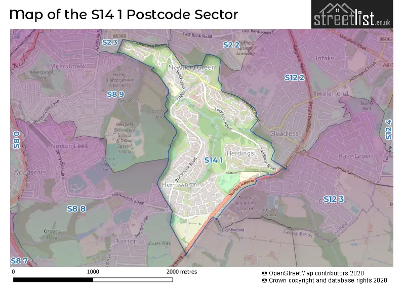
The S14 1 postcode sector stands on the Derbyshire and South Yorkshire border.
Did you know? According to the 2021 Census, the S14 1 postcode sector is home to a bustling 9,724 residents!
Given that each sector allows for 400 unique postcode combinations. Letters C, I, K, M, O and V are not allowed in the last two letters of a postcode. With 183 postcodes already in use, this leaves 217 units available.
The S14 1 postal code covers the settlement of SHEFFIELD.
The S14 1 Postcode shares a border with S2 2 (SHEFFIELD), S2 3 (SHEFFIELD, Heeley), S8 8 (SHEFFIELD), S8 9 (SHEFFIELD), S12 2 (SHEFFIELD) and S12 3 (SHEFFIELD, Ridgeway).
The sector is within the post town of SHEFFIELD.
S14 1 is a postcode sector within the S14 postcode district which is within the S Sheffield postcode area.
The Royal Mail delivery office for the S14 1 postal sector is the Sheffield City 2 Delivery Office.
The area of the S14 1 postcode sector is 0.87 square miles which is 2.26 square kilometres or 558.74 square acres.
Waterways within the S14 1 postcode sector include the Meers Brook.

Map of the S14 1 Postcode Sector
Explore the S14 1 postcode sector by using our free interactive map.
| S | 1 | 4 | - | 1 | X | X |
| S | 1 | 4 | Space | 1 | Letter | Letter |
Official List of Streets
SHEFFIELD (93 Streets)
Unofficial Streets or Alternative Spellings
Weather Forecast for S14 1
Press Button to Show Forecast for Gleadless
| Time Period | Icon | Description | Temperature | Rain Probability | Wind |
|---|---|---|---|---|---|
| 06:00 to 09:00 | Sunny day | 2.0°C (feels like 0.0°C) | 1.00% | N 4 mph | |
| 09:00 to 12:00 | Cloudy | 5.0°C (feels like 3.0°C) | 5.00% | NE 7 mph | |
| 12:00 to 15:00 | Overcast | 7.0°C (feels like 6.0°C) | 9.00% | ENE 4 mph | |
| 15:00 to 18:00 | Overcast | 8.0°C (feels like 7.0°C) | 9.00% | ENE 4 mph | |
| 18:00 to 21:00 | Cloudy | 7.0°C (feels like 5.0°C) | 8.00% | ENE 7 mph | |
| 21:00 to 00:00 | Cloudy | 4.0°C (feels like 2.0°C) | 8.00% | ENE 4 mph |
Press Button to Show Forecast for Gleadless
| Time Period | Icon | Description | Temperature | Rain Probability | Wind |
|---|---|---|---|---|---|
| 00:00 to 03:00 | Cloudy | 3.0°C (feels like 2.0°C) | 8.00% | NNE 4 mph | |
| 03:00 to 06:00 | Cloudy | 2.0°C (feels like 0.0°C) | 10.00% | NNE 4 mph | |
| 06:00 to 09:00 | Cloudy | 3.0°C (feels like 1.0°C) | 11.00% | NNE 4 mph | |
| 09:00 to 12:00 | Cloudy | 7.0°C (feels like 4.0°C) | 12.00% | ENE 9 mph | |
| 12:00 to 15:00 | Overcast | 9.0°C (feels like 6.0°C) | 18.00% | E 9 mph | |
| 15:00 to 18:00 | Cloudy | 9.0°C (feels like 7.0°C) | 22.00% | ENE 9 mph | |
| 18:00 to 21:00 | Cloudy | 8.0°C (feels like 6.0°C) | 20.00% | ENE 9 mph | |
| 21:00 to 00:00 | Cloudy | 6.0°C (feels like 3.0°C) | 18.00% | NE 9 mph |
Press Button to Show Forecast for Gleadless
| Time Period | Icon | Description | Temperature | Rain Probability | Wind |
|---|---|---|---|---|---|
| 00:00 to 03:00 | Light rain | 5.0°C (feels like 2.0°C) | 49.00% | NNE 11 mph | |
| 03:00 to 06:00 | Light rain | 5.0°C (feels like 2.0°C) | 51.00% | NNE 11 mph | |
| 06:00 to 09:00 | Heavy rain | 6.0°C (feels like 2.0°C) | 76.00% | NNE 13 mph | |
| 09:00 to 12:00 | Heavy rain | 7.0°C (feels like 4.0°C) | 79.00% | NNE 11 mph | |
| 12:00 to 15:00 | Heavy rain | 8.0°C (feels like 5.0°C) | 77.00% | NE 13 mph | |
| 15:00 to 18:00 | Light rain | 9.0°C (feels like 6.0°C) | 51.00% | N 11 mph | |
| 18:00 to 21:00 | Light rain shower (day) | 8.0°C (feels like 6.0°C) | 36.00% | N 9 mph | |
| 21:00 to 00:00 | Partly cloudy (night) | 6.0°C (feels like 4.0°C) | 11.00% | SE 7 mph |
Schools and Places of Education Within the S14 1 Postcode Sector
Woodlands Primary School
Academy sponsor led
Norton Avenue, Sheffield, South Yorkshire, S14 1SL
Head: Mrs Lauren Johnstone
Ofsted Rating: Good
Inspection: 2022-02-10 (806 days ago)
Website: Visit Woodlands Primary School Website
Phone: 01142396464
Number of Pupils: 484
House Prices in the S14 1 Postcode Sector
| Type of Property | 2018 Average | 2018 Sales | 2017 Average | 2017 Sales | 2016 Average | 2016 Sales | 2015 Average | 2015 Sales |
|---|---|---|---|---|---|---|---|---|
| Detached | £160,000 | 3 | £189,000 | 1 | £238,000 | 1 | £166,000 | 1 |
| Semi-Detached | £97,700 | 5 | £116,286 | 14 | £110,250 | 9 | £124,998 | 2 |
| Terraced | £93,404 | 47 | £92,717 | 63 | £86,177 | 36 | £73,583 | 63 |
| Flats | £79,304 | 13 | £49,429 | 7 | £47,750 | 6 | £47,435 | 7 |
Important Postcodes S14 1 in the Postcode Sector
S14 1LW is the postcode for Bankwood Primary School, Bankwood Close, and Bankwood Childrens Centre, Bankwood Close
S14 1PQ is the postcode for Gleadless Medical Centre, 636 Gleadless Road
S14 1SL is the postcode for Valley Park Primary School, Norton Avenue, VALLEY PARK PRIMARY SCHOOL, NORTON AVENUE, SHEFFIELD, Valley Park Community Primary School, Norton Avenue, and Woodlands Primary School, Norton Avenue
S14 1TD is the postcode for Herdings Community and Heritage Centre, Morland Road
| The S14 1 Sector is within these Local Authorities |
|
|---|---|
| The S14 1 Sector is within these Counties |
|
| The S14 1 Sector is within these Water Company Areas |
|